 Block
From the record
6 National Register listings published here.
Sources: the National Register database, National Park Service
67 topographic sheets cover 22 settlements here, and 6 properties are on the National Register of Historic Places.
6 National Register listings published here.
Sources: the National Register database, National Park Service
Every property in this county listed on the National Register of Historic Places, with the year it was listed and the federal nomination document.
| Photograph | Property | Type | Listed | Reference |
|---|---|---|---|---|
 | Henry and Barbara Bierbauer House | building | 2016 | 16000379 |
 | Benjamin Boorman House | building | 1976 | 76000066 |
 | Juneau County Courthouse | building | 1982 | 82001846 |
 | William and Mary Shelton Farmstead | building | 2004 | 04000810 |
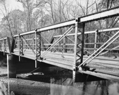 | Sprague Bridge | structure | 1995 | 94001574 |
 | Weston-Babcock House | building | 1979 | 79000089 |
Every wildfire the federal occurrence database records inside this county: 1,269 of them, burning about 3,234 acres. 16 started naturally and 79 were recorded as arson. Each settlement page carries the fires within five miles of it.
| Reported cause | Fires |
|---|---|
| Debris and open burning | 397 |
| Equipment and vehicle use | 270 |
| Missing data/not specified/undetermined | 208 |
| Recreation and ceremony | 84 |
| Arson/incendiarism | 79 |
| Railroad operations and maintenance | 54 |
| Smoking | 44 |
| Power generation/transmission/distribution | 33 |
| Misuse of fire by a minor | 32 |
| Other causes | 31 |
| Fireworks | 21 |
| Natural | 16 |
The five largest, by the area the report gives. One of them was set deliberately.
| Date | Cause | Size | Reported by | Name on the report |
|---|---|---|---|---|
| 10 April 2003 | Debris and open burning | 384 acres | Necedah National Wildlife Refuge | PR27 |
| 13 April 2015 | Railroad operations and maintenance | 337 acres | Wisconsin Department of Natural Resources | RAILROAD |
| 18 April 2020 | Recreation and ceremony | 234 acres | Necedah National Wildlife Refuge | WINCR_FY20_WF_17TH ST FIRE |
| 2 May 1992 | Equipment and vehicle use | 161 acres | Wisconsin Department of Natural Resources | not named |
| 14 April 2000 | Railroad operations and maintenance | 140 acres | Wisconsin Department of Natural Resources | not named |
| 4 May 2005 | Debris and open burning | 112 acres | Necedah National Wildlife Refuge | F-5 MID CANFIELD |
| 23 November 2002 | Recreation and ceremony | 75 acres | Necedah National Wildlife Refuge | THIRD FLOWAGE |
| 15 August 2004 | Arson/incendiarism | 66 acres | Wisconsin Department of Natural Resources | not named |
Every settlement page carries the fires within five miles of it - see the settlement index below.
The NOAA Storm Events Database holds 390 reports for this county, causing 3 deaths, 42 injuries and about $52,190,060 in recorded property damage. Each settlement page carries the reports that name it.
| Kind of event | Reports |
|---|---|
| Thunderstorm Wind | 160 |
| Hail | 141 |
| Flood | 39 |
| Tornado | 27 |
| Heavy Rain | 10 |
| Lightning | 6 |
| Flash Flood | 6 |
| Funnel Cloud | 1 |
The most serious of them, by death, then injury, then recorded damage. The accounts are quoted exactly as the forecast office filed them.
| When | Event | Place named | Harm | What the report says |
|---|---|---|---|---|
| August 1985 | Tornado (F2) | not stated | 2 killed, 22 hurt, $2,500,000 | no account filed |
| April 1957 | Tornado (F4) | not stated | 1 killed, $25,000 | no account filed |
| July 1983 | Tornado (F3) | not stated | 8 hurt, $250,000 | no account filed |
| October 1984 | Tornado (F2) | not stated | 3 hurt, $250,000 | no account filed |
| March 1982 | Tornado (F1) | not stated | 2 hurt, $250,000 | no account filed |
| June 2008 | Lightning | Necedah Hornsburg Ar | 2 hurt | Two individuals were struck in the Town of Germantown. One of the victims did require treatment for the minor injuries. |
| June 1996 | Lightning | Hustler | 2 hurt | no account filed |
| August 1979 | Tornado (F1) | not stated | 1 hurt, $250,000 | no account filed |
| May 1988 | Tornado (F1) | not stated | 1 hurt, $2,500 | no account filed |
| May 1964 | Tornado (F2) | not stated | 1 hurt, $2,500 | no account filed |
| August 2018 | Flash Flood | Union Center | $28,700,000 | Runoff from heavy rain caused extensive flooding to occur in Elroy from the Baraboo River. Between 25 and 30 homes had to be evacuated. Numerous homes had water several inches to a few feet deep in the basements. Nine homes likely will have to be torn down. Damages in Elroy totaled nearly $6.5 million. The flooding along the Baraboo River also hit Wonewoc hard causing officials to evacuate the western half of the town. Dozens of homes had water in the basements with at least 4 of them suffering collapsed walls. Flooding along the Lemonweir River near Mauston caused Interstates 90/94 to be closed in both directions and washed out a rail line that caused the eastbound Amtrak Empire Builder to be stopped near Tomah. Passengers had to remain on the stopped train overnight until repairs to the rail line were completed. Flooding in Mauston damaged some homes with at least one a total loss when a basement wall collapsed. Flood waters from Webster Creek covered portions of State Highway 80 between New Lisbon and Elroy. State Highway 33 was under water in places between Union Center and Wonewoc because of flood waters from the Baraboo River. State Highway 82 was closed between Elroy and Mauston due to flood waters from Cleaver Creek. Portions of State Highway 58 south of Mauston was covered in flood waters from Onemile and Stewart Creeks. U.S. Highway 12 was closed between Mauston and Lyndon Station because of flooding on the Lemonweir River. County highways across the southern part of the county that were closed included: N, G, HH and FF. Numerous local and township roads were also closed. |
| May 2011 | Tornado (EF2) | Mather | $4,400,000 | This tornado entered into Juneau County southwest of Mather and then tracked northeast across the Necedah Wildlife Refuge between Mather and Finley damaging numerous trees. As the tornado approached Finley, it grew in size and was nearly a half mile wide as it crossed County Road F east of Finley. In this area, numerous trees were snapped or blown down with some of them landing on nearby homes. At a cranberry business east of Finley, all of the outbuildings and sheds were demolished and tossed into nearby fields and a loading deck platform and trucks were heavily damaged. Thick wooden power poles in this area were snapped or sheared off over a half mile long stretch. The tornado then weakened as it moved northeast toward the Wood-Juneau County line with damage to trees and some minor roof and siding damage. Total damages across Juneau county from this tornado were estimated to be $4.4 million. |
| June 2008 | Flood | Mauston | $3,500,000 | High water caused problems in Elroy due to flooding along the Baraboo River and there were several mudslides. Homes along Lincoln, Lake, South Brooklyn, and Franklin streets were evacuated after the river broke its banks early Sundy afternoon, June 8th. About 16 families were displaced in Wonewoc as well. Mudslides began to occur along Highways 82 and 80.||Sections of the Elroy-Sparta State bicycle trail were also damaged and caused a closure. ||There was concern about high water in Mauston as well, especially along the Lemonweir River. |
| June 2008 | Flood | Mauston | $2,800,000 | Evacuations were needed in many areas due to rising water levels. Numerous mudslides were also reported. |
| April 2026 | Tornado (EF3) | Union Center | $2,050,000 | This tornado moved into Juneau County from Vernon County where it intensified quickly and hit a residence at EF-3 intensity, destroying the home's above ground level. As the tornado moved east, it produced significant tree damage before weakening in intensity as it approached State Road 80, where it damaged a few more homes and several outbuildings. The tornado continued northeast, dealing intermittent tree and structural damage at EF-1 intensity along its path until it dissipated just west of Overgaard Road. |
| September 2010 | Flood | Finley | $900,000 | The Yellow, Lemonweir and Wisconsin Rivers along with their tributaries flooded, which caused road closures, evacuations, and damage to some roads, homes and businesses. People were evacuated from a campground east of Mauston along the Lemonweir River, while a dozen campers, campsites and sheds were ruined. In Necedah, water rose onto the property of several businesses, while homes on the east side of town were evacuated. Five homes and 2 businesses incurred major damage, while 14 homes and 1 business reported minor damage. Some specific road closures included County Roads G and F, and 11th Street, as well as County Roads HH and N near Lyndon Station. |
| June 2022 | Tornado (EF1) | Mauston | $775,000 | An EF1 tornado developed just to the southwest of Mauston and tracked northeast before dissipating just west of the Wisconsin River south of Castle Lake Dam. In Mauston, the tornado caused roof damage to the hospital and a restaurant, blew windows out of several vehicles near the hospital, took down several stop lights, blew over parked semis, snapped power poles and downed several trees in a mobile home park that damaged numerous homes. In Veteran's Memorial Park, stands for the baseball field were overturned with some blown across the street and the scoreboard was ripped off its posts. A tree fell on the roof of an apartment complex damaging the roof and allowing water to leak into some units. Northeast of Mauston over rural parts of Juneau County, the damage was mainly limited to trees. The mayor of Mauston issued a disaster declaration. |
| April 2026 | Hail | Lyndon Station | $660,000 | A trained spotter reported 3 inch diameter hail 5 miles southeast of Lyndon Station. |
| June 2000 | Tornado (F1) | New Lisbon | $500,000 | no account filed |
| August 2020 | Flash Flood | Cutler | $330,000 | Heavy rain from thunderstorms caused flash flooding to occur across the southern sections of Juneau County. In and near Mauston, flood waters almost reached the entrance door to the sheriff's office and numerous roads were covered by water. Roads were closed due to high water north of Camp Douglas. In Camp Douglas, several homes were flooded with water waist high in the basements. |
| June 2008 | Flash Flood | Elroy | $275,000 | Mudslides were reported along Highway 80. A trailer park was evacuated. |
| October 1992 | Tornado (F1) | not stated | $250,000 | no account filed |
| August 1979 | Tornado (F2) | not stated | $250,000 | no account filed |
| May 1964 | Tornado (F2) | not stated | $250,000 | no account filed |
| September 2018 | Flash Flood | Union Center | $230,000 | Several roads were closed with high water covering others across the southern portions of Juneau County. In Mauston, flooding from the Lemonweir River closed several city streets and prompted evacuations along Maple Drive where the utilities were shut off. Some homes had water in their basements. |
| June 2000 | Thunderstorm Wind | Camp Douglas | $175,000 | no account filed |
| June 2008 | Flood | Wonewoc | $150,000 | Water was over Geier Road due to flooding from Crossman Creek. |
| June 2008 | Flash Flood | Elroy | $110,000 | Flash flooding hit parts of southern Juneau County hard with water over several roads and some mudslides. Many area creeks rose very rapidly as well. |
| June 2022 | Tornado (EF2) | Cutler | $100,000 | This EF2 tornado developed in Monroe County and moved into Juneau County northwest of Cutler. The tornado moved northeast and dissipated in the Necedah Wildlife Refuge. Extensive tree damage occurred along the path. |
| June 2008 | Flood | Mauston | $100,000 | Water was over numerous roads from 3 miles southwest of Mauston to 3 miles southeast of Mauston. |
| August 2005 | Tornado (F1) | Necedah | $100,000 | no account filed |
| June 2000 | Thunderstorm Wind | Mauston | $100,000 | no account filed |
| June 1999 | Lightning | Mauston | $100,000 | no account filed |
| September 1997 | Thunderstorm Wind | Mauston | $80,000 | no account filed |
| June 2000 | Thunderstorm Wind | Camp Douglas | $75,000 | no account filed |
| May 2000 | Hail | Necedah | $70,000 | no account filed |
| July 2023 | Thunderstorm Wind | South Necedah | $65,000 | Emergency manager reported fallen trees and power outages in Necedah. |
| May 2000 | Hail | Necedah | $65,000 | no account filed |
| June 2000 | Thunderstorm Wind | Camp Douglas | $60,000 | no account filed |
| March 2017 | Lightning | Cloverdale | $55,000 | A fire caused by a lightning strike, destroyed a house west of Necedah. |
| May 2000 | Hail | New Lisbon | $55,000 | no account filed |
| August 2006 | Hail | Union Center | $50,000 | no account filed |
| June 2000 | Thunderstorm Wind | (Vok)Volk Aaf Camp D | $50,000 | no account filed |
| June 2000 | Thunderstorm Wind | New Lisbon | $50,000 | no account filed |
| September 2022 | Hail | Finley | $45,000 | Up to 3 inch diameter hail was reported east of Finley that caused damage to some vehicles. |
| June 1998 | Thunderstorm Wind | Mauston | $45,000 | no account filed |
| August 2006 | Hail | Wonewoc | $40,000 | no account filed |
| May 1998 | Thunderstorm Wind | Mauston | $38,000 | no account filed |
| July 2023 | Thunderstorm Wind | Mauston | $30,000 | Emergency manager reported downed trees and power outages. |
| April 2011 | Tornado (EF1) | South Necedah | $30,000 | A National Weather Service storm survey team confirmed an EF1 tornado south of Necedah. The tornado first touched down near the intersection of Paradise Lane and 25th Street and produced EF0 damage. The tornado briefly produced EF1 damage for about three fourths of a mile from T Lane through Padre Pio Drive. A mobile home was rolled over and pine trees were snapped. The tornado continued east-northeast and produced EF0 damage to pine trees around County Road G before ending near the Wisconsin River. |
| August 2006 | Hail | Necedah | $30,000 | no account filed |
| August 2006 | Hail | Elroy | $30,000 | no account filed |
| June 2000 | Hail | (Vok)Volk Aaf Camp D | $30,000 | no account filed |
| June 2000 | Hail | Camp Douglas | $30,000 | no account filed |
| September 2022 | Hail | Finley | $25,000 | Egg sized hail was reported north of Finley. |
| September 2022 | Hail | New Miner | $25,000 | Up to 3 inch diameter hail was reported northeast of New Miner. |
| August 2019 | Thunderstorm Wind | Mauston | $25,000 | Numerous trees and power lines were blown down in and around Mauston. One tree landed on and damaged a garage. After the storm, about two-thirds of the city was without power. |
| May 2017 | Thunderstorm Wind | Mauston | $25,000 | A barn was destroyed south of Mauston. |
| May 2011 | Hail | Lemonweir | $25,000 | Up to baseball sized hail fell just east of Mauston. |
| August 2006 | Hail | Union Center | $25,000 | no account filed |
The Survey's mineral resources record lists 4 workings inside this county. 2 still produce and 2 are closed or unrecorded. Each settlement page carries the workings within five miles of it.
| Commodity | Workings |
|---|---|
| Stone, Crushed/Broken | 4 |
The least common of them first, because a county's hundredth gravel pit says nothing its first ten did not.
| Where | Site | Commodity | Status | Recorded |
|---|---|---|---|---|
| Clark Quarry | Stone, Crushed/Broken | Past Producer | ||
| Elroy Quarry | Stone, Crushed/Broken | Producer | ||
| Juneau County Operations | Stone, Crushed/Broken | Producer | ||
| Necedah Quarry | Stone, Crushed/Broken | Past Producer |
Named settlements recorded in the Geographic Names Information System, each with the topographic sheets covering it. Villages, hamlets and abandoned places alike. Each is shown with the nearest named watercourse or landform and the survey quadrangle it falls on.
Orange town · 54618 · Near Castle Rock · Camp Douglas quadrangle
13 sheets, 1919 to 1985
Lyndon town · 53944 · On Gilmore Creek · Wisconsin Dells North quadrangle
16 sheets, 1901 to 1990
Lindina town · 53948 · Near Riley Hollow · New Lisbon South quadrangle
12 sheets, 1921 to 1985
Lyndon Station village · 53944 · On Tracy Creek · Lyndon Station quadrangle
16 sheets, 1901 to 1990
Lisbon town · 53950 · On Little Lemonweir River · New Lisbon North quadrangle
12 sheets, 1921 to 1985
Orange town · 54618 · On Fountain Creek · New Lisbon North quadrangle
12 sheets, 1921 to 1985
Union Center village · 53968 · Near Tiedtke Valley · Hillsboro quadrangle
11 sheets, 1927 to 1985