 Block
From the record
7 National Register listings published here, 1 of them a National Historic Landmark.
Sources: the National Register database, National Park Service
41 topographic sheets cover 16 settlements here, and 7 properties are on the National Register of Historic Places.
7 National Register listings published here, 1 of them a National Historic Landmark.
Sources: the National Register database, National Park Service
Every property in this county listed on the National Register of Historic Places, with the year it was listed and the federal nomination document.
| Photograph | Property | Type | Listed | Reference |
|---|---|---|---|---|
 | Bonnie Oaks Historic District | district | 1986 | 86000626 |
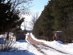 | Fountain Lake Farm | site | 1990 | 90000471 |
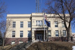 | Marquette County Courthouse and Marquette County Sheriff's Office and Jail | building | 1982 | 82000685 |
 | Montello Commercial Historic District | district | 1996 | 96000238 |
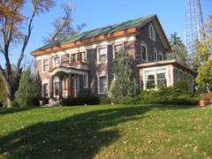 | Charles Samuel Richter House | building | 1996 | 96000908 |
| St. John's Evangelical Lutheran Church | building | 2025 | 100012024 | |
 | Vaughn's Hall and Blacksmith Shop | building | 2007 | 07000556 |
Every wildfire the federal occurrence database records inside this county: 1,214 of them, burning about 2,490 acres. 37 started naturally and 83 were recorded as arson. Each settlement page carries the fires within five miles of it.
| Reported cause | Fires |
|---|---|
| Debris and open burning | 439 |
| Equipment and vehicle use | 256 |
| Missing data/not specified/undetermined | 195 |
| Arson/incendiarism | 83 |
| Other causes | 62 |
| Power generation/transmission/distribution | 41 |
| Natural | 37 |
| Recreation and ceremony | 31 |
| Smoking | 22 |
| Fireworks | 18 |
| Misuse of fire by a minor | 16 |
| Railroad operations and maintenance | 14 |
The five largest, by the area the report gives. One of them was set deliberately.
| Date | Cause | Size | Reported by | Name on the report |
|---|---|---|---|---|
| 14 April 2003 | Debris and open burning | 572 acres | Wisconsin Department of Natural Resources | CRYSTAL LAKE |
| 10 April 1996 | Debris and open burning | 67 acres | Wisconsin Department of Natural Resources | not named |
| 1 April 2000 | Arson/incendiarism | 51 acres | Wisconsin Department of Natural Resources | not named |
| 21 June 1994 | Natural | 48 acres | Wisconsin Department of Natural Resources | not named |
| 13 November 1994 | Missing data/not specified/undetermined | 45 acres | Wisconsin Department of Natural Resources | not named |
| 4 April 2004 | Debris and open burning | 45 acres | Wisconsin Department of Natural Resources | not named |
| 13 April 1995 | Smoking | 44 acres | Wisconsin Department of Natural Resources | not named |
| 5 November 1999 | Debris and open burning | 38 acres | Wisconsin Department of Natural Resources | not named |
Every settlement page carries the fires within five miles of it - see the settlement index below.
The NOAA Storm Events Database holds 237 reports for this county, causing no deaths, 2 injuries and about $14,975,960 in recorded property damage. Each settlement page carries the reports that name it.
| Kind of event | Reports |
|---|---|
| Thunderstorm Wind | 125 |
| Hail | 73 |
| Tornado | 25 |
| Flood | 7 |
| Flash Flood | 4 |
| Funnel Cloud | 2 |
| Heavy Rain | 1 |
The most serious of them, by death, then injury, then recorded damage. The accounts are quoted exactly as the forecast office filed them.
| When | Event | Place named | Harm | What the report says |
|---|---|---|---|---|
| May 2000 | Hail | Westfield | 2 hurt, $1,000,000 | no account filed |
| June 2008 | Flash Flood | Endeavor | $8,750,000 | Heavy rains resulted in flash flooding from the Endeavor area to the Montello area. Water depths on road surfaces reached 3 feet or more and there were gravel washouts. One hundred homes were affected with at least some flooding. Two hundred homes had minor damage. Eighty-five homes had major damage, and one home was destroyed (total of 6 million for all home property losses). Fifty businesses had minor damage, 10 had major damage, and 1 was destroyed (total of 750 thousand for all business property losses). Crops losses were estimated at 2 million. Public sector damage was about $2 million. There were several roads and bridges that sustained damage. |
| August 2018 | Flood | Montello | $2,000,000 | The Montello River flooded portions of Montello as it flowed out of Lake Montello. Major flooding occurred and the Main St. bridge was closed due to the high water of the river impacting the bridge. Approximately, 150 homes and businesses were flooded. Much of the flooding occurred on or near Montello St., Island Dr., Park St., Main St., and portions of Cass St. The major flooding continued into September. |
| June 2004 | Tornado (F2) | Packwaukee | $1,000,000 | A strong tornado spun up about a half-mile east of Interstate 39/STH 51, near the intersection of Fawn Ct. and CTH M, or 3.5 NNW of Packwaukee. This tornado increased to F2 strength (estimated 140-150 mph) as it tore east/southeast through the southern part of Montello. Numerous trees were uprooted. Four homes were destroyed, 25 sustained major damage, and 142 had minor damage. In addition, 9 agricultural buildings were damaged or destroyed. The tornado ended in a swampy, Fox River bottom-land area about 4 miles southeast of Montello (1 mile short of the county line and south of CTH C and east STH 22). The responsible supercell also spun up a different tornado earlier in Adams County. Prop damage estimated at $1.0 M. Average path width was about 175 yards. |
| August 2018 | Thunderstorm Wind | Oxford | $300,000 | A swath of widespread tree and crop damage across the southern portion of the county including Endeavor and Montello. Sections of trees and crops completely flattened, and some structural damage from fallen trees or due to the strong downburst winds. Various roads closed due to fallen trees. 2 million dollars in crop damage from straight-line winds, tornadoes, and flooding is estimated throughout the county for late August into early September. |
| June 2008 | Tornado (EF1) | Briggsville | $300,000 | This tornado started in Adams county and moved southeastward into Marquette county at the intersection of 1st Ave. and Glen Ave., and dissipated just north of STH 23, mid-way between 3rd Ave. and Neenah Creek. It resulted in minor damage to 4 residential homes, minor damage to 2 agricultural buildings, major damage to 2 agricultural buildings, and destroyed 1 agrcultural building. Total residential damage was about $100K and total agricultural damage was about $200K. Some corn crop was also damaged. The lat/long starting location in Marquette County was 43.68597/-89.59951, and the ending location was 43.66950/-89.56055. DI#1 (SBO), DOD6. Winds estimated at 100 mph. Average path width was about 50 yards. |
| July 1955 | Tornado (F2) | not stated | $250,000 | no account filed |
| June 2022 | Thunderstorm Wind | Westfield | $200,000 | A swath of significant tree damage due to estimated winds of 100 mph. Trees uprooted or snapped. Swaths of pine trees leveled. One farm outbuilding was destroyed with another partially damaged. A few other buildings with roof covering removed. |
| August 2007 | Thunderstorm Wind | Oxford | $100,000 | Powerful thunderstorm wind gusts to around 56 knots (65 mph) toppled many trees and power-poles/power-lines in a swath from Oxford to Montello. |
| August 2005 | Tornado (F1) | Westfield | $100,000 | This tornado spun up at 1708CST about 1.7 miles north-northeast of Westfield, or about 0.4 miles north-northwest of the intersection of CTH E and 7th Court, just east of Interstate 39/STH 51. The tornado headed northeast and ended at 1722CST about 7.2 miles northeast of Westfield, or about 0.4 mile north of the intersection of CTH Z and 11th Rd. O one property, a residential home sustained minor roof damage, and there was minor damage to two out-buildings and farm equipment/machinery. On another property, minor damage to a silo was noted. Extensive tree and power-line damage was reported along the entire path of the tornado. Average path length was about 75 yards. |
| May 1998 | Thunderstorm Wind | Countywide | $100,000 | no account filed |
| September 2011 | Thunderstorm Wind | Westfield | $75,000 | Severe thunderstorms with strong wind gusts produced damage across Marquette County, including a 10-mile wide swath of damage from west of Westfield to Germania. The damaging winds downed power lines and trees, including a tree that crushed a parked car on CTH B in Montello. Five homes received minor damage to roofs, siding and gutters due to tree debris striking the homes. At the peak of the storm, 937 homes were without electricity. A mesonet site one mile north of Westfield recorded a 67 mph (58 knot) wind gust. |
| May 2024 | Tornado (EF1) | Budsin | $60,000 | Intermittent damage path with numerous branches downed along with 30 to 40 trees snapped, topped or uprooted. |
| April 2026 | Tornado (EF1) | Briggsville | $51,000 | The tornado started near Grouse Rd east of Briggsville and then tracked to the northeast. The worst damage was to an onion farm south of County Road O. The tornado crossed Interstate 39 and dissipated near County Road CX. Storm chaser videos and photos along with security camera footage from the onion farm confirm the tornado. |
| October 2013 | Tornado (EF0) | Endeavor | $50,000 | Tornado began near the intersection of County Highway P and State Highway 23 just west of the I-39 interchange about 1.2 miles southwest of Endeavor. The tornado moved north along a 1.78 mile long path ending just under 1 mile northwest of Endeavor about 1/2 mile north of Gail Avenue. The maximum path width was 50 yards. Trees were snapped along the path, with one tree falling on a house and car, destroying the car and damaging the roof of the house. Other homes had shingle damage with a section of metal roof peeled off of a farm house. The wind damage was consistent with an EF-0 tornado with winds of 70 to 85 mph. |
| July 2007 | Flash Flood | Harrisville | $50,000 | Slow moving thunderstorm cells trained over the same area northeast of Harrisville near and along CTH E (3 NE Harrisville or about 2.7 miles west-southwest of Budsin), resulting in a flash flood. Water depths on road surfaces reached 2 to 3 feet, and water entered basements of several homes. Damage occurred to personal property in the basements. WSR-88D Doppler radar rainfall estimates were on the order of 3 to 4 inches. |
| May 2004 | Flash Flood | Packwaukee | $50,000 | no account filed |
| July 2008 | Thunderstorm Wind | Westfield | $40,000 | Powerful thunderstorm wind gusts toppled large trees and broke branches that brought down some power-lines in locations scattered across the county. Three trailer homes about 6 miles east-northeast of Montello were damaged as two large trees came down in the winds. |
| June 2000 | Thunderstorm Wind | Briggsville | $40,000 | no account filed |
| July 2009 | Thunderstorm Wind | Westfield | $30,000 | Severe thunderstorms produced damaging winds estimated up to 65 mph that caused extensive tree damage in a 4 mile wide swath from Westfield to Montello. Trees fell on two homes at Buffalo Lake causing roof damage. Several power lines were damaged by tree debris and there were scattered power outages in the Montello area. Most likley this wind damage was associated with the forward flank downdraft of the supercell thunderstorm that generated a F1 tornado in Marquette County a few minutes later. |
| June 2008 | Thunderstorm Wind | Endeavor | $25,000 | Powerful thunderstorm winds knocked down large trees and power-lines. |
| July 1983 | Tornado (F1) | not stated | $25,000 | no account filed |
| June 1965 | Tornado (F1) | not stated | $25,000 | no account filed |
| July 1959 | Tornado (F2) | not stated | $25,000 | no account filed |
| June 2025 | Thunderstorm Wind | Packwaukee | $20,000 | Numerous trees down throughout the county. |
| May 2024 | Tornado (EF0) | Budsin | $20,000 | Intermittent damage path with numerous branches downed along with upwards of 40 trees snapped, topped or uprooted. One house sustained substantial roof damage from a fallen tree. Minor garage damage was all noted from falling tree debris. |
| May 2012 | Thunderstorm Wind | Montello | $20,000 | A trained spotter reported many trees and power lines downed by powerful thunderstorm wind gusts, estimated up to 75 mph (65 knots) in Montello. Metal shingles were torn off of a barn roof. |
| May 2012 | Thunderstorm Wind | Briggsville | $20,000 | Fire department officials reported many trees and power lines downed by powerful thunderstorm wind gusts, estimated up to 85 mph (74 knots) in Briggsville. Tree debris damaged several cars, with roof damage to several homes. |
| June 2019 | Thunderstorm Wind | Montello | $15,000 | Several trees down and extensive pier damage on Lake Puckaway. |
| June 2001 | Thunderstorm Wind | Westfield | $15,000 | no account filed |
| June 2020 | Thunderstorm Wind | Westfield | $10,000 | Many trees and tree limbs down in the western portion of the county. A small shed was rolled down a driveway near Westfield. A significant amount of trees down in the Endeavor area with a reported wind gust of 60 mph. |
| June 2017 | Thunderstorm Wind | Harrisville | $10,000 | Numerous branches and trees down throughout the county with the exception of the southwest side of the county. |
| May 2013 | Thunderstorm Wind | Oxford | $10,000 | Law enforcement officials reported trees and power lines downed by powerful thunderstorm winds that gusted to an estimated 65 mph (56 knots) along a path from 1 mile northeast of Oxford to 2 miles south of Westfield. |
| July 2009 | Tornado (EF1) | Glenoak | $10,000 | A tornado spun up about 2 miles west-northwest of Glen Oak (about 3 miles southwest of Montello), roughly mid-way between Williams Lake and Metcalf Lake. It proceded to move southeast on a 150 degree bearing to where Grand Ave. crosses into Green Lake County. This weak tornado eventually dissipated about 2 miles northwest of Dalton in southwest Green Lake County. Mainly tree damage was noted along the track in Marquette County. However, one small pole shed lost some roof shingles, and minor roof damage was infliced upon two mobile trailer homes along Grand Ave. Minor damage to corn crops was noted as well. The starting ending GPS coordinates in Marquette County were 43.76112/-89.36820 and 43.71007, with a damage indicator of DI 27 (TH), DOD 3. The wind speed was estimated at 95 mph. The average path width was about 75 yards. |
| June 2002 | Flash Flood | Neshkoro | $10,000 | no account filed |
| June 2000 | Flood | Briggsville | $10,000 | no account filed |
| July 2022 | Thunderstorm Wind | Oxford | $8,000 | Scattered trees down across the county. |
| June 2022 | Thunderstorm Wind | Westfield | $8,000 | Numerous softwood trees snapped or uprooted. Roof panels missing from building. |
| June 2017 | Thunderstorm Wind | Briggsville | $8,000 | Numerous trees down scattered across the county. |
| June 2022 | Thunderstorm Wind | Westfield | $7,000 | Multiple trees and branches down in the area. |
| June 2018 | Thunderstorm Wind | Oxford | $7,000 | Scattered trees, branches, and power lines down throughout the county. |
| June 2022 | Thunderstorm Wind | Oxford | $6,000 | Multiple trees and branches down in Oxford. |
| June 1996 | Thunderstorm Wind | Westfield | $6,000 | no account filed |
| June 2022 | Thunderstorm Wind | Westfield | $5,000 | Several trees snapped or topped. |
| September 2018 | Flood | Packwaukee | $5,000 | Highway D, which crosses Buffalo Lake and connects two sections of Packwaukee, was closed as a portion of the road was washed out by several inches of rain. This required residents to travel 1 hour around the lake to reach the other section of Packwaukee. |
| June 2017 | Thunderstorm Wind | Westfield | $5,000 | Multiple branches and trees down in Lawrence. |
| July 2015 | Thunderstorm Wind | Oxford | $5,000 | Sporadic trees down throughout the county, including a couple power lines down. Electrical power was out for much of the northern portion of the county. |
| July 2006 | Thunderstorm Wind | Countywide | $5,000 | Tree and power line damage scattered across the whole county. |
| June 1998 | Thunderstorm Wind | Montello | $5,000 | no account filed |
| April 1997 | Thunderstorm Wind | Montello | $5,000 | no account filed |
| June 1996 | Thunderstorm Wind | Brooks | $5,000 | no account filed |
| June 2019 | Thunderstorm Wind | Oxford | $4,000 | Scattered branches and trees down throughout the county. |
| July 2017 | Thunderstorm Wind | Montello | $4,000 | Multiple trees down throughout Montello. |
| June 2017 | Thunderstorm Wind | Neshkoro | $4,000 | Trees and power lines down in Neshkoro. |
| July 2022 | Thunderstorm Wind | Westfield | $3,000 | Scattered trees down. |
| June 2017 | Thunderstorm Wind | Westfield | $3,000 | A few trees uprooted. |
| July 2016 | Thunderstorm Wind | Germania | $3,000 | Trees down in the township of Shields. |
| July 2005 | Thunderstorm Wind | Montello | $3,000 | no account filed |
| May 1988 | Tornado (F1) | not stated | $2,500 | no account filed |
| May 2024 | Thunderstorm Wind | Oxford | $2,000 | Two trees down in the Township of Oxford. |
The Survey's mineral resources record lists 8 workings inside this county. 4 still produce and 4 are closed or unrecorded. Each settlement page carries the workings within five miles of it.
| Commodity | Workings |
|---|---|
| Sand and Gravel, Construction | 4 |
| Granite | 1 |
| Stone | 1 |
| Stone, Crushed/Broken | 1 |
| Stone, Dimension | 1 |
The least common of them first, because a county's hundredth gravel pit says nothing its first ten did not.
| Where | Site | Commodity | Status | Recorded |
|---|---|---|---|---|
| Mecan Rhyolite Quarry | Stone, Dimension | Past Producer | ||
| Montello Granite Quarry | Granite | Past Producer | ||
| Own Crews | Stone | Unknown | ||
| Pockrandt Quarry | Stone, Crushed/Broken | Producer | ||
| Frazene Pit | Sand and Gravel, Construction | Producer | ||
| Frinak Pit | Sand and Gravel, Construction | Past Producer | ||
| Marquette County Operations | Sand and Gravel, Construction | Producer | ||
| Richards Pit | Sand and Gravel, Construction | Producer |
Named settlements recorded in the Geographic Names Information System, each with the topographic sheets covering it. Villages, hamlets and abandoned places alike. Each is shown with the nearest named watercourse or landform and the survey quadrangle it falls on.
Packwaukee town · 53949 · On Chapman Creek · Endeavor quadrangle
12 sheets, 1902 to 1990
Douglas town · 53952 · On O'Keefe Creek · Briggsville quadrangle
15 sheets, 1902 to 1990
Harris town · 53964 · On Westfield Creek · Westfield East quadrangle
10 sheets, 1957 to 1990