 Block
From the record
6 National Register listings published here.
Sources: the National Register database, National Park Service
60 topographic sheets cover 44 settlements here, and 6 properties are on the National Register of Historic Places.
6 National Register listings published here.
Sources: the National Register database, National Park Service
Every property in this county listed on the National Register of Historic Places, with the year it was listed and the federal nomination document.
| Photograph | Property | Type | Listed | Reference |
|---|---|---|---|---|
| Laney School | building | 1998 | 98001463 | |
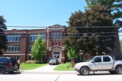 | Lincoln School | building | 2013 | 13000865 |
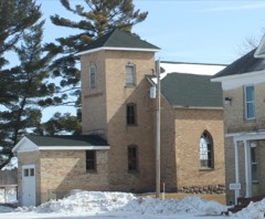 | Lutheran Indian Mission | building | 1980 | 80000195 |
| Shawano Main Street Historic District | district | 1999 | 99000440 | |
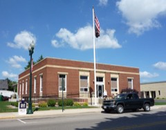 | Shawano Post Office | building | 2000 | 00001241 |
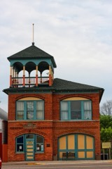 | Tigerton Village Hall and Engine House | building | 2008 | 08001036 |
Every wildfire the federal occurrence database records inside this county: 619 of them, burning about 1,017 acres. 13 started naturally and 53 were recorded as arson. Each settlement page carries the fires within five miles of it.
| Reported cause | Fires |
|---|---|
| Debris and open burning | 189 |
| Equipment and vehicle use | 139 |
| Missing data/not specified/undetermined | 110 |
| Arson/incendiarism | 53 |
| Recreation and ceremony | 28 |
| Power generation/transmission/distribution | 26 |
| Smoking | 23 |
| Fireworks | 18 |
| Natural | 13 |
| Misuse of fire by a minor | 11 |
| Other causes | 7 |
| Railroad operations and maintenance | 2 |
The five largest, by the area the report gives. None of them was recorded as arson.
| Date | Cause | Size | Reported by | Name on the report |
|---|---|---|---|---|
| 5 May 2005 | Debris and open burning | 75 acres | Menominee Tribe | CECIL/UND. |
| 31 October 1999 | Recreation and ceremony | 65 acres | Wisconsin Department of Natural Resources | not named |
| 19 April 1998 | Debris and open burning | 40 acres | Wisconsin Department of Natural Resources | not named |
| 13 April 2005 | Debris and open burning | 40 acres | Wisconsin Department of Natural Resources | not named |
| 22 April 1996 | Debris and open burning | 30 acres | Wisconsin Department of Natural Resources | not named |
| 21 April 2007 | Missing data/not specified/undetermined | 29 acres | Wisconsin Department of Natural Resources | not named |
| 29 April 1997 | Debris and open burning | 27 acres | Wisconsin Department of Natural Resources | not named |
| 23 April 1994 | Debris and open burning | 27 acres | Wisconsin Department of Natural Resources | not named |
Every settlement page carries the fires within five miles of it - see the settlement index below.
The NOAA Storm Events Database holds 287 reports for this county, causing no deaths, 4 injuries and about $6,787,800 in recorded property damage. Each settlement page carries the reports that name it.
| Kind of event | Reports |
|---|---|
| Thunderstorm Wind | 172 |
| Hail | 68 |
| Tornado | 28 |
| Funnel Cloud | 7 |
| Lightning | 6 |
| Flash Flood | 4 |
| Flood | 2 |
The most serious of them, by death, then injury, then recorded damage. The accounts are quoted exactly as the forecast office filed them.
| When | Event | Place named | Harm | What the report says |
|---|---|---|---|---|
| July 1997 | Thunderstorm Wind | Wittenberg | 1 hurt, $300,000 | no account filed |
| April 1974 | Tornado (F2) | not stated | 1 hurt, $250,000 | no account filed |
| July 2010 | Thunderstorm Wind | Belle Plaine | 1 hurt | Thunderstorm winds downed a tree which struck a woman in the town of Belle Plaine. The injury was non-life threatening. |
| March 1998 | Lightning | Shawano | 1 hurt | no account filed |
| April 1984 | Tornado (F3) | not stated | $2,500,000 | no account filed |
| June 1969 | Tornado (F3) | not stated | $2,500,000 | no account filed |
| June 1984 | Tornado (F1) | not stated | $250,000 | no account filed |
| September 1980 | Tornado (F1) | not stated | $250,000 | no account filed |
| May 2017 | Thunderstorm Wind | Shawano Lake | $100,000 | Thunderstorm winds downed at least two dozen trees, causing damage to eight houses on the north shore of Shawano Lake. |
| July 2002 | Thunderstorm Wind | Countywide | $100,000 | no account filed |
| June 2017 | Tornado (EF1) | Angelica | $75,000 | An EF1 tornado formed and moved north-northeast on the west side of the city of Pulaski. The tornado ripped off a garage door and one side of the garage collapsed inward (DI 2, DOD 4). Another nearby garage door (on a different property) collapsed and one side was heavily damaged (DI 2, DOD 4). In addition, a barn's roof was collapsed (DI 1, DOD 5). Several dozen trees were uprooted in wet soil or heavily damaged (DI 27 and 28, DOD 2 and 3) in the path of the tornado. |
| August 2013 | Thunderstorm Wind | Morgan | $75,000 | A severe thunderstorm with estimated winds of 85 to 95 mph, caused damage to trees and two houses in Gresham. Both houses lost portions of the roof deck, in addition to several dozen trees on the property. |
| July 2010 | Thunderstorm Wind | Wittenberg | $50,000 | Thunderstorm winds downed or snapped numerous trees and downed power lines throughout Wittenburg. The Wittenberg-Birnamwood High School had about 75 feet of its rubber membrane roof and underlying foam insulation peeled from the west side of the gymnasium. Several large pine trees along the south side of the school were uprooted. A camper trailer was blown from its support pad and rolled about 40 feet before resting on its roof. Two of the three pools at the water treatment plant had portions of their plastic thermal covers blown off. Downed trees blocked State Highway 45 causing authorities to close the road for several hours. More than 140 homes were damaged, but damage to most of the homes was minor. |
| August 2003 | Thunderstorm Wind | Shawano | $50,000 | no account filed |
| July 2010 | Thunderstorm Wind | Bowler | $35,000 | Thunderstorm winds downed trees at numerous locations across western Shawano County. The most concentrated damage was about 3 miles northwest of Bowler where estimated wind gusts of 85 to 95 mph from a microburst caused significant damage. A stand of pine trees 200 yards wide by 400 yards long was almost completely flattened with several trees snapped about 10 to 15 feet above the ground. A home and work shed were damaged by fallen trees and a truck was crushed. About a mile to the east a barn and outbuilding were flattened by the wind. |
| June 2017 | Tornado (EF0) | Hofa Park | $25,000 | This tornado, west of Angelica, heavily damaged an old barn (DI 1, DOD 6) and partially tore the roof off an outbuilding (DI 1, DOD 2). Another old barn had most of its roof blown off (DI 1, DOD 5). A nearby home had roof damage (DI 2, DOD 2) and its garage door partially collapsed inward. |
| September 1991 | Tornado (F0) | not stated | $25,000 | no account filed |
| July 1983 | Tornado (F1) | not stated | $25,000 | no account filed |
| May 1980 | Tornado (F1) | not stated | $25,000 | no account filed |
| June 1964 | Tornado (F1) | not stated | $25,000 | no account filed |
| August 2011 | Lightning | Hofa Park | $20,000 | A house in the Town of Maple Grove was struck by lightning, causing a fire that destroyed its second floor. Time and damage total are estimates. |
| July 2015 | Tornado (EF0) | Pella Arpt | $10,000 | A brief, weak tornado tore off part of a barn roof (DI 1, DOD 2) and sent wooden pallets into a nearby field. |
| June 2012 | Thunderstorm Wind | Angelica | $10,000 | Thunderstorm winds destroyed a camper trailer and downed numerous trees in the Angelica area. |
| June 2005 | Thunderstorm Wind | Wittenberg | $10,000 | no account filed |
| July 1997 | Thunderstorm Wind | Morgan | $10,000 | no account filed |
| August 1996 | Thunderstorm Wind | Bonduel | $10,000 | no account filed |
| June 1998 | Thunderstorm Wind | Angelica | $8,000 | no account filed |
| June 1998 | Thunderstorm Wind | Briarton | $8,000 | no account filed |
| August 1996 | Thunderstorm Wind | Bonduel | $5,000 | no account filed |
| July 1994 | Thunderstorm Wind | Shawano | $5,000 | no account filed |
| July 1994 | Thunderstorm Wind | Gresham | $5,000 | no account filed |
| July 1994 | Tornado (F1) | Aniwa | $5,000 | no account filed |
| June 1998 | Thunderstorm Wind | Hofa Park | $3,000 | no account filed |
| July 1997 | Thunderstorm Wind | Tigerton | $3,000 | no account filed |
| August 2011 | Thunderstorm Wind | Mattoon | $2,000 | Thunderstorm winds downed several trees and power lines in Mattoon causing damage to some structures, including the concession stand and dugout at a local ballpark. |
| June 1998 | Thunderstorm Wind | Wittenberg | $2,000 | no account filed |
| September 1997 | Thunderstorm Wind | Shawano | $2,000 | no account filed |
| August 1996 | Thunderstorm Wind | Tilleda | $2,000 | no account filed |
| June 2007 | Tornado (EF1) | Mattoon | $1,000 | The long-track tornado first touched down about two miles east of Mattoon at 4:31 PM CDT and slowly intensified as it quickly exited the county about three miles east-northeast of Mattoon and moved into Menominee Co. Several trees were knocked down and uprooted (DI 28, DOD 4). This segment of the tornado was rated EF1 with an average path width of 250 yards. |
| May 2007 | Thunderstorm Wind | Shawano | $1,000 | A shed was damaged and trees were down on the east side of the city of Shawano. |
| July 1997 | Thunderstorm Wind | Wittenberg | $1,000 | no account filed |
| July 1997 | Lightning | Wittenberg | $1,000 | no account filed |
| June 1997 | Thunderstorm Wind | Wittenberg | $1,000 | no account filed |
| June 1997 | Thunderstorm Wind | Gresham | $1,000 | no account filed |
| September 1997 | Thunderstorm Wind | Morgan | $1,000 | no account filed |
| June 2016 | Thunderstorm Wind | Navarino | $800 | Thunderstorm winds tore part of the roof from a garage near Navarino. |
| March 2026 | Hail | Thornton | - | Quarter size hail fell in Thornton. The time of this report is an estimate based on radar data. |
| April 2026 | Flash Flood | Green Vly | - | Rainfall amounts of 3 to 5 inches in a short time caused several streets to close in southern and eastern Shawano County due to flash flooding. The time of this report is an estimate based on radar data. |
| April 2026 | Flash Flood | Navarino | - | Highway 156 closed due to high water after 1 inch of rain fell in a short time in Navarino. Water level is high enough to hit and deflect off the support beams on the underside of the bridge. |
| April 2025 | Thunderstorm Wind | Mattoon | - | Thunderstorm winds downed trees and power poles near Matoon. The time of this report is an estimate based on radar data. |
| April 2025 | Thunderstorm Wind | Eland | - | Thunderstorm winds snapped and uprooted trees near Eland. The time of this report is an estimate based on radar data. |
| April 2025 | Tornado (EF0) | Birnamwood | - | A tornado developed near Birnamwood at 10:00 pm CDT, then tracked northeast before lifting at 10:02 pm CDT. The tornado produced damage to an outbuilding and uprooted trees. Total path length is estimated to be 1.88 miles long, with a width of 55 yards. Peak wind estimated to be around 80 mph. |
| April 2025 | Tornado (EF0) | Mattoon | - | A tornado developed near Matoon at 10:02 pm CDT, then tracked northeast through Matoon and entering Menominee County at 10:09 pm CDT. The tornado produced damage to some buildings and uprooted trees. Total path length is estimated to be 6.25 miles long, with a width of 65 yards. Peak wind estimated to be around 80 mph. |
| June 2025 | Thunderstorm Wind | Tigerton | - | Thunderstorm winds uprooted multiple trees in Tigerton. The time of this report is an estimate based on radar data. |
| June 2025 | Flash Flood | Frazer | - | Rainfall amounts of 2 to 3 inches in a short time caused caused a section of County Road F southeast of Bonduel to close due to flash flooding on the roadway. The time of this report is an estimate based on radar data. |
| June 2025 | Hail | Navarino | - | Nickel size hail fell near Navarino. The time of this report is an estimate based on radar data. |
| June 2025 | Hail | Shawano | - | Quarter size hail fell in Shawano. |
| June 2025 | Hail | Shawano | - | Quarter size hail fell near Shawano. The time of this report is an estimate based on radar data. |
| July 2025 | Hail | Aniwa | - | Golf ball size hail fell near Birnamwood. The time of this report is an estimate based on radar data. |
| July 2025 | Thunderstorm Wind | Aniwa | - | Thunderstorm winds downed several trees in Aniwa. The time of this report is an estimate based on radar data. |
The Survey's mineral resources record lists 126 workings inside this county. 11 still produce and 115 are closed or unrecorded. Each settlement page carries the workings within five miles of it.
| Commodity | Workings |
|---|---|
| Sand and Gravel, Construction | 116 |
| Stone, Crushed/Broken | 10 |
The least common of them first, because a county's hundredth gravel pit says nothing its first ten did not.
| Where | Site | Commodity | Status | Recorded |
|---|---|---|---|---|
| Beech Drive Limestone Deposit | Stone, Crushed/Broken | Occurrence | ||
| Gehm Quarry and Mill | Stone, Crushed/Broken | Producer | ||
| Limekiln Quarry | Stone, Crushed/Broken | Producer | ||
| Limekiln Quarry | Stone, Crushed/Broken | Producer | ||
| Mapleview Road Dolomite Quarry | Stone, Crushed/Broken | Past Producer | ||
| Meisner Road Granite Quarry | Stone, Crushed/Broken | Past Producer | ||
| Pittsfield Quarry | Stone, Crushed/Broken | Past Producer | ||
| Quarry Road Dolomite Quarry | Stone, Crushed/Broken | Past Producer | ||
| Tigerton Pond Granite Quarry | Stone, Crushed/Broken | Past Producer | ||
| Zimmerman Limekiln Quarry | Stone, Crushed/Broken | Producer | ||
| Adams Beach Sand Pit | Sand and Gravel, Construction | Past Producer | ||
| Albert Fandrey Gravel Deposit | Sand and Gravel, Construction | Occurrence | ||
| Apple Road Gravel Deposit | Sand and Gravel, Construction | Occurrence | ||
| Apple Road Gravel Pit | Sand and Gravel, Construction | Past Producer | ||
| Bahr Lake Gravel Deposit | Sand and Gravel, Construction | Occurrence | ||
| Bernard Fuller Gravel Pit | Sand and Gravel, Construction | Past Producer | ||
| Birnamwood Gravel Deposit #1 | Sand and Gravel, Construction | Occurrence | ||
| Birnamwood Gravel Deposit #2 | Sand and Gravel, Construction | Occurrence | ||
| Birnamwood Gravel Pit #1 | Sand and Gravel, Construction | Past Producer | ||
| Birnamwood Gravel Pit #2 | Sand and Gravel, Construction | Past Producer | ||
| Birnamwood Gravel Pit #3 | Sand and Gravel, Construction | Past Producer | ||
| Boldig Road Gravel Pit | Sand and Gravel, Construction | Past Producer | ||
| Bonduel Gravel Pit | Sand and Gravel, Construction | Past Producer | ||
| Bonduel Pit | Sand and Gravel, Construction | Producer | ||
| Bowler Gravel Deposit | Sand and Gravel, Construction | Occurrence | ||
| Briarton Gravel Pit #1 | Sand and Gravel, Construction | Past Producer | ||
| Briarton Gravel Pit #2 | Sand and Gravel, Construction | Past Producer | ||
| Carlson Gravel Deposit | Sand and Gravel, Construction | Occurrence | ||
| Cemetery Road Gravel Pit | Sand and Gravel, Construction | Past Producer | ||
| Church Road Gravel Deposit #1 | Sand and Gravel, Construction | Occurrence | ||
| Church Road Gravel Deposit #2 | Sand and Gravel, Construction | Occurrence | ||
| Danbury Gravel Pit | Sand and Gravel, Construction | Past Producer | ||
| Deger Lane Gravel Deposit | Sand and Gravel, Construction | Occurrence | ||
| Dobratz Gravel Deposit | Sand and Gravel, Construction | Occurrence | ||
| Donald Mielke Sand Deposit | Sand and Gravel, Construction | Occurrence | ||
| Druckery Pit | Sand and Gravel, Construction | Past Producer | ||
| Earl Mielke Sand Deposit | Sand and Gravel, Construction | Occurrence | ||
| Ehrenreich Sand Pit | Sand and Gravel, Construction | Past Producer | ||
| Eland Gravel Deposit | Sand and Gravel, Construction | Occurrence | ||
| Eland Gravel Pit | Sand and Gravel, Construction | Past Producer | ||
| Elm Road Gravel Deposit | Sand and Gravel, Construction | Occurrence | ||
| Elm Road Gravel Pit | Sand and Gravel, Construction | Past Producer | ||
| Embarrass Sand and Gravel Pit | Sand and Gravel, Construction | Past Producer | ||
| Evelyn Hansen Gravel Pit | Sand and Gravel, Construction | Past Producer | ||
| Flat Rock Road Gravel Deposit | Sand and Gravel, Construction | Occurrence | ||
| Foster Pit | Sand and Gravel, Construction | Producer | ||
| Gollnow Sand Pit | Sand and Gravel, Construction | Past Producer | ||
| Green Valley Road Gravel Pit | Sand and Gravel, Construction | Past Producer | ||
| Gresham Gravel Pit | Sand and Gravel, Construction | Past Producer | ||
| Haase Gravel Deposit | Sand and Gravel, Construction | Occurrence | ||
| Herman Creek Gravel Pit #1 | Sand and Gravel, Construction | Past Producer | ||
| Herman Creek Road Gravel Pit | Sand and Gravel, Construction | Past Producer | ||
| Holy Hill Road Gravel Deposit #1 | Sand and Gravel, Construction | Occurrence | ||
| Holy Hill Road Gravel Deposit #2 | Sand and Gravel, Construction | Occurrence | ||
| Holy Hill Road Gravel Pit | Sand and Gravel, Construction | Past Producer | ||
| Island Gravel Pit | Sand and Gravel, Construction | Past Producer | ||
| Kamineski Gravel Pit | Sand and Gravel, Construction | Past Producer | ||
| Kersten Lake Gravel Deposit | Sand and Gravel, Construction | Occurrence | ||
| Kersten Lake Gravel Pit | Sand and Gravel, Construction | Past Producer | ||
| Kingbird Lane Gravel Deposit | Sand and Gravel, Construction | Occurrence | ||
| Krakow Gravel Pit | Sand and Gravel, Construction | Past Producer | ||
| Kriewaldt Gravel Pit | Sand and Gravel, Construction | Past Producer | ||
| Kroening Lake Gravel Pit | Sand and Gravel, Construction | Past Producer | ||
| Kussmann Sand Pit | Sand and Gravel, Construction | Past Producer | ||
| Laatsch Gravel Pit | Sand and Gravel, Construction | Past Producer | ||
| Lily Pond Road Gravel Pit | Sand and Gravel, Construction | Past Producer | ||
| Lodge Road Gravel Pit | Sand and Gravel, Construction | Past Producer | ||
| Lone Maple Road Gravel Pit | Sand and Gravel, Construction | Past Producer | ||
| Marquardt Pit | Sand and Gravel, Construction | Past Producer | ||
| Mcdevitt Road Gravel Pit | Sand and Gravel, Construction | Past Producer | ||
| Meverden Gravel Pit | Sand and Gravel, Construction | Past Producer | ||
| Minniecheske Gravel Pit | Sand and Gravel, Construction | Past Producer | ||
| Montoure Road Gravel Pit | Sand and Gravel, Construction | Past Producer | ||
| Nichols Drive Sand Pit | Sand and Gravel, Construction | Past Producer | ||
| O and S Pit | Sand and Gravel, Construction | Producer | ||
| Oak Avenue Gravel Pit | Sand and Gravel, Construction | Past Producer | ||
| Oakcrest Drive Gravel Pit | Sand and Gravel, Construction | Past Producer | ||
| Packard Creek Gravel Pit #1 | Sand and Gravel, Construction | Past Producer | ||
| Packard Creek Gravel Pit #2 | Sand and Gravel, Construction | Past Producer | ||
| Pella Opening Road Sand Pit | Sand and Gravel, Construction | Past Producer | ||
| Pensaukee Lakes Gravel Deposit | Sand and Gravel, Construction | Occurrence | ||
| Pensaukee River Gravel Deposit #1 | Sand and Gravel, Construction | Occurrence | ||
| Pine Lane Gravel Pit | Sand and Gravel, Construction | Past Producer | ||
| Pulcifer Gravel Pit | Sand and Gravel, Construction | Past Producer | ||
| Pulcifer Road Gravel Pit | Sand and Gravel, Construction | Past Producer | ||
| Radke Sand Pit | Sand and Gravel, Construction | Past Producer | ||
| Railroad Creek Gravel Deposit | Sand and Gravel, Construction | Occurrence | ||
| Ranch Road Gravel Pit | Sand and Gravel, Construction | Past Producer | ||
| Rank Gravel Pit | Sand and Gravel, Construction | Past Producer | ||
| Ray Fischer Gravel Deposit | Sand and Gravel, Construction | Occurrence | ||
| Reissmann Gravel Deposit | Sand and Gravel, Construction | Occurrence | ||
| River Road Gravel Pit | Sand and Gravel, Construction | Past Producer | ||
| Riverside Gravel Deposit | Sand and Gravel, Construction | Occurrence | ||
| Rocky Lane Gravel Pit | Sand and Gravel, Construction | Past Producer | ||
| Roy Lenzer Gravel Pit | Sand and Gravel, Construction | Past Producer | ||
| Ruth Buch Gravel Deposit | Sand and Gravel, Construction | Occurrence | ||
| Ruth Varley Gravel Pit | Sand and Gravel, Construction | Past Producer | ||
| Shawano County Pits | Sand and Gravel, Construction | Producer | ||
| Shawano County Pits | Sand and Gravel, Construction | Producer | ||
| Slab City Creek Gravel Pit #1 | Sand and Gravel, Construction | Past Producer | ||
| Slab City Creek Gravel Pit #2 | Sand and Gravel, Construction | Past Producer | ||
| Slab City Creek Gravel Pit #3 | Sand and Gravel, Construction | Past Producer | ||
| Slab City Gravel Pit | Sand and Gravel, Construction | Past Producer | ||
| Small Creek Gravel Deposit | Sand and Gravel, Construction | Occurrence | ||
| Small Pond Gravel Deposit | Sand and Gravel, Construction | Occurrence | ||
| Spencer Creek Gravel Pit | Sand and Gravel, Construction | Past Producer | ||
| Spiegel Road Gravel Pit | Sand and Gravel, Construction | Past Producer | ||
| Split Rock Sand Deposit | Sand and Gravel, Construction | Occurrence | ||
| Stezenski Gravel Pit | Sand and Gravel, Construction | Past Producer | ||
| Strehlow Sand Deposit | Sand and Gravel, Construction | Occurrence | ||
| Swampside Gravel Deposit | Sand and Gravel, Construction | Occurrence | ||
| Swampside Gravel Pit | Sand and Gravel, Construction | Past Producer | ||
| Tiger Creek Gravel Pit #1 | Sand and Gravel, Construction | Past Producer | ||
| Tilleda Gravel Deposit #1 | Sand and Gravel, Construction | Occurrence | ||
| Tilleda Gravel Deposit #2 | Sand and Gravel, Construction | Occurrence | ||
| Westphal Pit | Sand and Gravel, Construction | Producer | ||
| White Clay Lake Gravel Pit | Sand and Gravel, Construction | Past Producer | ||
| Willow Road Gravel Deposit | Sand and Gravel, Construction | Occurrence | ||
| Wilson Creek Gravel Deposit | Sand and Gravel, Construction | Occurrence | ||
| Wilson Creek Gravel Pit | Sand and Gravel, Construction | Past Producer | ||
| Wittenberg Gravel Deposit | Sand and Gravel, Construction | Occurrence | ||
| Wittenberg Gravel Pit | Sand and Gravel, Construction | Past Producer | ||
| Wohler Gravel Deposit | Sand and Gravel, Construction | Occurrence | ||
| Wohler Sand & Gravel Pit | Sand and Gravel, Construction | Past Producer | ||
| Zimmerman Pit | Sand and Gravel, Construction | Producer | ||
| Zimmerman Pit | Sand and Gravel, Construction | Unknown |
Named settlements recorded in the Geographic Names Information System, each with the topographic sheets covering it. Villages, hamlets and abandoned places alike. Each is shown with the nearest named watercourse or landform and the survey quadrangle it falls on.
Grant town · 54928 · On Middle Branch Embarrass River · Marion quadrangle
8 sheets, 1955 to 1984
Herman town · 54948 · On North Branch Embarrass River · Gresham quadrangle
7 sheets, 1954 to 1984
Wittenberg town · 54499 · On Packard Creek · Wittenberg quadrangle
7 sheets, 1954 to 1984
Fairbanks town · 54486 · On Split Rock Creek · Tigerton quadrangle
7 sheets, 1955 to 1984