BlockBefore
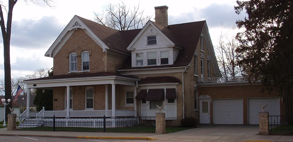
Photograph of Lachmund Family House
Photograph by Wonder al, CC BY-SA 3.0. Via Wikimedia Commons.

Lachmund Family House

Built in 1878 (Queen Anne style). Listed on the National Register of Historic Places in 2000.

From the record

“The Lachmund Family House, also known as the Halasz/Lachmund House, is a historic house located at 717 Water Street in Sauk City, Wisconsin. It is locally significant in the social history of Sauk City.”

Wikipedia article Lachmund Family House, CC BY-SA 4.0.

One of 58 National Register listings published here for Sauk County · listed in 2000 · category: Building · built in 1878, Queen Anne style.

Sources: the Wikipedia article · the case file at the National Archives · the National Register database, National Park Service
The listing

  • What is counted as historic. The nomination lists 2 buildingss as contributing to the listing.
  • Address. 717 Water St., Sauk City, 53583
  • When was it listed? March 2000
  • Category. building
  • Village. Sauk City village
  • When was it built? 1878
  • Architectural style. Queen Anne style, Gothic Revival
  • National Register reference number. 00000257 - the number the National Park Service assigned this property when it was listed, and the key its nomination file is catalogued under at the National Archives.

The ground it stands on

28,526 words

The chapter on Sauk City Village in A Standard History of Sauk County, Wisconsin, published 1918 names Sauk City. This is what it says, exactly as the scans read.

Black Hawk - Discontinued postoffice in the Town of Troy named for the Indian Chief, Black Hawk, leader of the Indians in the Black Hawk war. After the battle near Sauk City the Indians fled through the wilderness near where the hamlet is located.

Passage source: A Standard History of Sauk County, Wisconsin, published 1918.

Sauk City - Village first called Harszthy for Count Augustine Harszthy, one of the founders. The name was difficult to remember so it was changed to Westfield, but as the word city, when attached to names of places, was popular then,' it was later called Sauk City, after the name of the county.

Passage source: A Standard History of Sauk County, Wisconsin, published 1918.

Machine-read from a century-old scan, so expect the errors a machine makes: misspelled names, dropped words, stray characters.

Read the whole chapter on Sauk City Village - 28,526 words on its settlement, mills, schools and churches.

Fires near this property

126 since 1992

Regional context, not property-specific evidence. The federal wildfire occurrence database lists 126 fires within 5 miles of Lachmund Family House between 1992 and 2020, burning about 387 acres in total. None started naturally. 4 were recorded as arson. Distance is straight-line from the map coordinates, so a fire counted here may appear on a neighbouring settlement's page as well.

Reported cause Fires
Debris and open burning48
Equipment and vehicle use36
Missing data/not specified/undetermined14
Recreation and ceremony8
Power generation/transmission/distribution5
Arson/incendiarism4
Smoking4
Misuse of fire by a minor4
Other causes2
Railroad operations and maintenance1

The most recent of them, most recent first, with the day each was reported and the service that recorded it.

DateCause SizeReported by Name on the report
5 September 2005Missing data/not specified/undeterminedunder an acreWisconsin Department of Natural Resourcesnot named
29 September 2012Recreation and ceremonyunder an acreWisconsin Department of Natural ResourcesTRUSSEL SMOKE
6 August 2012Debris and open burningunder an acreWisconsin Department of Natural ResourcesFITZGERALD YARD
5 August 2012Recreation and ceremonyunder an acreWisconsin Department of Natural ResourcesSNUFFYS
27 August 2020Equipment and vehicle useunder an acreWisconsin Department of Natural ResourcesBREUNIG RD
26 August 2020Debris and open burning1.9 acresWisconsin Department of Natural ResourcesMAGAZINE UNIT
24 August 2010Debris and open burningunder an acreWisconsin Department of Natural ResourcesMATCH BAG
24 July 2008Recreation and ceremony4.8 acresWisconsin Department of Natural Resourcesnot named

Every fire recorded in Sauk County

Mines and quarries near this property

2 within 5 miles

Regional context, not property-specific evidence. The federal mineral resources record lists 2 workings within 5 miles of Lachmund Family House: 2 producers. All of them still produce. What was taken out: Sand and Gravel, Construction, Stone, Crushed/Broken. Distance is straight-line from the map coordinates, so a quarry counted here may appear on a neighbouring settlement's page as well.

Where SiteCommodity StatusRecorded
Matousek QuarryStone, Crushed/BrokenProducer
Pulvermacher PitSand and Gravel, ConstructionProducer

Every working recorded in Sauk County

Storms near this property

15 since 2006

Regional context, not property-specific evidence. The National Weather Service names Sauk City, the town this property stands in, in 15 storm reports between 2006 and 2024: 6 thunderstorm wind, 5 hail, 2 lightning, 2 flash flood. No death or injury is recorded in these reports. Each account below is quoted exactly as the forecast office filed it, from the NOAA Storm Events Database, and each date opens the federal record of that event.

WhenEvent Place namedHarm What the report says
August 2007LightningSauk City$1,900,000Lightning struck a commerical peg farm near Sauk City, killing about 1900 pigs. The exact location of the farm isn't known.
August 2006LightningSauk City$25,000Lightning struck a home, resulting in a minor fire.
June 2014Thunderstorm WindSauk City$15,000Numerous trees down 18 to 24 inches in diameter.
July 2020Thunderstorm WindSauk City$5,000Some trees and power lines down in Sauk City.
July 2016Thunderstorm WindSauk City$5,000Trees and power lines down.
July 2023Thunderstorm WindSauk City$3,000A large branch around 8 inches in diameter down on a house.
June 2013Flash FloodSauk City$3,000A road 3 miles north of Sauk City was reported to be covered by 1 to 3 feet of water due to heavy rain.
May 2024Thunderstorm WindSauk City$2,000Scattered tree limbs down in Sauk City and Prairie Du Sac.
July 2019Flash FloodSauk City$500Highway 12 in Sauk City is closed due to heavy rainfall and flash flooding after a quick couple inches of rain.
July 2012Thunderstorm WindSauk City-Law enforcement officials reported building damage in Sauk City caused by severe thunderstorm wind gusts estimated at 80 mph (70 knots).
April 2014HailSauk City-no account filed
April 2013HailSauk City-no account filed
June 2010HailSauk City-no account filed
April 2008HailSauk City-no account filed
March 2007HailSauk City-no account filed

Every storm recorded in Sauk County

Map coverage status

No historic map-sheet match is published for this property yet. That does not mean no map exists. This record needs a coordinate-quality review before it can be joined to a sheet boundary. Browse the county's mapped places while that work is pending.

Listed places nearby

6 within 8 miles

Other National Register properties close enough to walk or drive between, ordered by distance from this one. Both positions come from the same geocoding pass that matched these properties to their map sheets.

Photograph PropertyDistance Listed
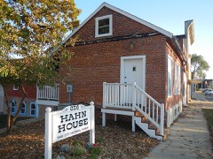
Otto Sr. and Lisette Hahn Houseunder 500 feet2012
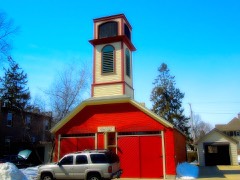
Sauk City Fire Station0.2 miles1999
Sauk City High School0.2 miles1989
Freethinkers` Hall0.3 miles1988
August W. Derleth House0.9 miles1991
Tripp Memorial Library and Hall1.3 miles1981

Sources for this property

National Archives recordThe nomination case file for reference 00000257 in Record Group 79.
Wikipedia articleCommunity-written account of this property, licensed CC BY-SA.
Sauk CountyAll 58 listed properties in this county.

Provenance

  • Listing record. National Park Service National Register of Historic Places, listed-properties dataset, current to 2026-05-22.
  • Map join. Address geocoded through the United States Census geocoder, then tested against the published boundary of every sheet in the USGS Historical Topographic Map Collection.
  • How this page is made. Listing fields come from federal records; map-sheet coverage is a labelled coordinate-to-boundary calculation, not a source-field claim.
  • Wildfire. Short, Karen C. 2022. Spatial wildfire occurrence data for the United States, 1992-2020 [FPA_FOD_20221014]. 6th Edition. Fort Collins, CO: Forest Service Research Data Archive. https://doi.org/10.2737/RDS-2013-0009.6 Collected with United States Government funding and usable without additional permissions or fees.
  • Mines and quarries. USGS Mineral Resources Data System (MRDS) https://mrdata.usgs.gov/mrds/ A work of the United States government, no copyright under 17 U.S.C. 105.
  • Storms. NOAA National Centers for Environmental Information, Storm Events Database https://www.ncei.noaa.gov/stormevents/ A work of the United States government, no copyright under 17 U.S.C. 105. Narratives are quoted verbatim from the National Weather Service report and are not edited or summarised.