BlockBefore
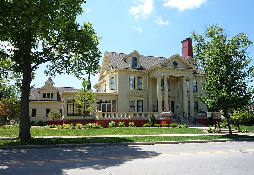
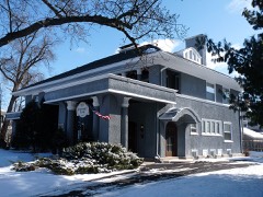
Photograph of Marathon County Historical Museum
Photograph by Bobak Ha'Eri, CC BY 3.0. Via Wikimedia Commons.

Cyrus C. Yawkey House

Built in 1900 (Neoclassical architecture). Listed on the National Register of Historic Places in 1974.

From the record

“The Yawkey House History Museum is museum located in Wausau, Marathon County, Wisconsin, United States. It is the Cyrus Carpenter Yawkey House, a house listed on the National Register of Historic Places in 1974.”

Wikipedia article Marathon County Historical Museum, CC BY-SA 4.0.

One of 33 National Register listings published here for Marathon County · listed in 1974 · category: Building · built in 1900, Neoclassical architecture, by George W. Maher.

Sources: the Wikipedia article · the case file at the National Archives · the National Register database, National Park Service

The listing

  • What is counted as historic. The nomination lists 1 building as contributing to the listing.
  • Still standing. The Park Service records this property as extant.
  • Listed as. Yawkey, Cyrus C., House - the National Register files a house under its owner's surname.
  • Address. 403 McIndoe St., Wausau
  • When was it listed? December 1974
  • Category. building
  • City. Wausau city
  • When was it built? 1900
  • Architectural style. Neoclassical architecture
  • Architect. George W. Maher
  • National Register reference number. 74000098 - the number the National Park Service assigned this property when it was listed, and the key its nomination file is catalogued under at the National Archives.

What happened here

An account from the chapter on Wausau city. The inset identifies its exact source book and publication year.

From History of Marathon County, Wisconsin and Representative Citizens, published 1913 - Wausau City

And Represextatre Citizens 271

In April, 1866, there was a high freshet which swept away the bridge (at the falls), went over the guardlock, and people living on Shingle street removed with their goods in time to escape destruction. The east end of the guardlock was swept away, the wall of water coming down washed out the street, tore away the pier under the slough bridge and also the conductor between the Clarke and Plumer's mill, a part of Clarke's mill, and some lumber and logs.

Read the rest of this passage

The ground it stands on

13,120 words

The chapter on Wausau City in History of Marathon County, Wisconsin and Representative Citizens, published 1913 names Wausau. This is what it says, exactly as the scans read.

The Mechanics Ridge settlement, the first in the county, has already been alluded to. It was a settlement made by mechanics, who carried on farming more as a sideline, and in course of time all sold out except James W. Nutter, after whom Nutterville is named, who closed his eyes on that fann in 1898. The first German farmers in town of Wausau appeared about 1859, and were

Passage source: History of Marathon County, Wisconsin and Representative Citizens, published 1913.

Carl Kunz, Frederick Schniutzler, followed by Fred Dumdei, and George and Martin Reinhard. Others came soon after them, but the growth of the settlement on the east side of Wausau was much slower than on the west. There was a prejudice against the eastern lands. First, all lands were supposed to be unfit for agricultural purposes; that prejudice died out slowly, as the farms on the west improved; but it still existed to the unsettled land on the eastern portion, and settlers coming to Marathon county naturally would go where, there were already settlements, which was Main, Berlin, Stettin and Marathon City. The German settlers went into these towns where their countrymen were, with whom they could speak; while new Irish settlers went to the Irish settlement. The larger number of farmers did not go to the towns of Wausau and Easton. which was included in town Wausau, until after the close of the war, and then, after 1866, when there was a great immigration from Germany, many of whom went in the eastern settlement, including the present town of Texas.

Passage source: History of Marathon County, Wisconsin and Representative Citizens, published 1913.

Machine-read from a century-old scan, so expect the errors a machine makes: misspelled names, dropped words, stray characters.

Read the whole chapter on Wausau City - 13,120 words on its settlement, mills, schools and churches.

Fires near this property

57 since 1992

Regional context, not property-specific evidence. The federal wildfire occurrence database lists 57 fires within 5 miles of Cyrus C. Yawkey House between 1992 and 2020, burning about 24 acres in total. 1 started naturally. 4 were recorded as arson. Distance is straight-line from the map coordinates, so a fire counted here may appear on a neighbouring settlement's page as well.

Reported cause Fires
Equipment and vehicle use17
Missing data/not specified/undetermined16
Debris and open burning13
Arson/incendiarism4
Misuse of fire by a minor2
Smoking2
Natural1
Recreation and ceremony1
Railroad operations and maintenance1

The most recent of them, most recent first, with the day each was reported and the service that recorded it.

DateCause SizeReported by Name on the report
5 September 2005Equipment and vehicle useunder an acreWisconsin Department of Natural Resourcesnot named
13 September 2018Equipment and vehicle useunder an acreWisconsin Department of Natural Resources678
24 July 2000Equipment and vehicle useunder an acreWisconsin Department of Natural Resourcesnot named
22 July 2005Missing data/not specified/undeterminedunder an acreWisconsin Department of Natural Resourcesnot named
17 July 2018Missing data/not specified/undeterminedunder an acreWisconsin Department of Natural Resources11260
13 July 2006Equipment and vehicle useunder an acreWisconsin Department of Natural Resourcesnot named
12 July 2006Equipment and vehicle useunder an acreWisconsin Department of Natural Resourcesnot named
4 June 2020Missing data/not specified/undetermined1.0 acresWisconsin Department of Natural Resources10742

Every fire recorded in Marathon County

Mines and quarries near this property

9 within 5 miles

Regional context, not property-specific evidence. The federal mineral resources record lists 9 workings within 5 miles of Cyrus C. Yawkey House: 4 unknowns, 3 past producers, 2 producers. 2 still produce. What was taken out: Stone, Crushed/Broken, Stone, Sand and Gravel, Construction. Distance is straight-line from the map coordinates, so a quarry counted here may appear on a neighbouring settlement's page as well.

Where SiteCommodity StatusRecorded
3m PitSand and Gravel, ConstructionPast Producer
County PitSand and Gravel, ConstructionUnknown
Lotz PitSand and Gravel, ConstructionProducer
Minnesota Mining & Mfg Co-GreystoneStone, Crushed/BrokenProducer
Own CrewsStoneUnknown
Rib Mountain QuarryStone, Crushed/BrokenPast Producer
Stewart Avenue Granite QuarryStone, Crushed/BrokenPast Producer
Sunburst QuarryStoneUnknown
Wimmer QuarryStoneUnknown

Every working recorded in Marathon County

Storms near this property

60 of 96 shown

Regional context, not property-specific evidence. The National Weather Service names Wausau, the town this property stands in, in 96 storm reports between 1995 and 2026: 41 thunderstorm wind, 39 hail, 5 lightning, 4 heavy rain. The reports record 2 injuries. Each account below is quoted exactly as the forecast office filed it, from the NOAA Storm Events Database, and each date opens the federal record of that event.

WhenEvent Place namedHarm What the report says
September 2002Tornado (F1)Wausau1 hurt, $1,300,000no account filed
July 2010LightningWausau1 hurtA man was injured and taken to Aspirus Hospital after being struck by lightning while standing outside on Stewart Avenue in Wausau. The extent of his injuries were unknown.
June 2016Thunderstorm WindWausau$320,000Thunderstorm winds downed trees and power lines, and caused roof damage to a middle school as the storms moved through Wausau. Trees landed on the roofs of two houses and on several cars. A gust to 64 mph was measured at Wausau Downtown Airport.
August 2013LightningWausau$99,000A lightning strike sparked a fire which destroyed a duplex on Wausau's east side. No one was injured in the blaze. The time of this event was estimated based on news reports and radar data.
July 2024Flash FloodWausau$58,000Rainfall of 2 to 3 inches of rain in a short time caused flash flooding in Wausau and Weston during the late afternoon. Multiple roads were under water and closed with stalled vehicles in the deeper water.
August 2009Flash FloodWausau$10,000Slow moving thunderstorms dumped 3 to 5 inches of rain between 4:00 am and 8:30 am in Wausau. Water approached the roof of cars and manhole covers were blown off by the force of the water. A storm spotter measured 5.00 inches of rain during the period.
September 1997Heavy RainWausau$10,000no account filed
September 2019Thunderstorm WindWausau$5,000Thunderstorm winds uprooted several trees east of Riverview Elementary School and damaged the roof of a house.
June 1998Thunderstorm WindWausau$3,000no account filed
August 1996Thunderstorm WindWausau$2,000no account filed
April 2026Flash FloodWausau-Rainfall amounts of 1 to 2 inches in a short time caused street flooding in Wausau and flooding near Moon where a culvert was washed out.
April 2026HailWausau-Quarter size hail fell in Wausau.
May 2025HailWausau-Quarter size hail fell near Wausau.
April 2025HailWausau-Penny size hail fell near Wausau.
July 2023HailWausau-Half dollar size hail fell near Brokaw. The time of this report is an estimate based on radar data.
July 2023HailWausau-Half dollar size hail fell near Wausau.
July 2023HailWausau-Quarter size hail fell in Wausau. The time of this report is an estimate based on radar data.
July 2023HailWausau-Quarter size hail fell near Wausau.
June 2022Thunderstorm WindWausau-Thunderstorm winds downed trees in Wausau. The time of this report is an estimate based on radar data.
June 2022Thunderstorm WindWausau-Thunderstorms produced a wind gust to 69 mph at the Wausau downtown airport.
May 2021Thunderstorm WindWausau-Thunderstorm winds downed trees and power lines in Wausau. The time of this event is an estimate based on radar data.
July 2021Thunderstorm WindWausau-Thunderstorm winds downed trees in Wausau.
July 2021Thunderstorm WindWausau-A thunderstorm wind gust of 63 mph was measured at the Wausau Downtown Airport.
July 2021Thunderstorm WindWausau-A thunderstorm wind gust of 58 mph was measured at the Wausau Downtown Airport.
July 2021Thunderstorm WindWausau-Thunderstorm winds downed numerous trees and power lines in Wausau. The time of this event is an estimate based on radar data.
July 2020Thunderstorm WindWausau-Thunderstorm winds downed trees and powerlines in Wausau.
September 2019Thunderstorm WindWausau-A thunderstorm wind gust of 60 mph was measured near Wausau.
August 2019HailWausau-Nickel size hail fell near Wausau.
August 2018Thunderstorm WindWausau-Thunderstorm winds downed several trees and power lines in Wausau. The time of this report was estimated based on radar data.
June 2018HailWausau-A thunderstorm dropped quarter size hail as it passed through Wausau.
June 2018HailWausau-A thunderstorm dropped nickel size hail as it passed through Wausau.
April 2017HailWausau-Nickel size hail fell west of Wausau.
April 2017Thunderstorm WindWausau-Thunderstorm winds snapped and uprooted trees, and downed power lines in the vicinity of Horseshoe Springs Road and Sylvan Street in Wausau. The storms also produced pea size hail.
April 2017HailWausau-Nickel size hail fell in Wausau.
August 2016Thunderstorm WindWausau-Thunderstorm winds downed branches and a couple of trees in Wausau.
July 2016HailWausau-Quarter size hail fell in Wausau.
September 2015Heavy RainWausau-Heavy rain caused street flooding in Wausau.
December 2015Heavy RainWausau-Several rounds of heavy rain in Marathon County brought more than 2.5 inches of rain to the Wausau area. Runoff from the heavy rain caused roadside ditches to fill with water.
July 2015Thunderstorm WindWausau-Thunderstorm winds downed trees in Wausau.
July 2014Funnel CloudWausau-A funnel cloud formed under a weak thunderstorm on the northeast side of Wausau.
August 2014HailWausau-Nickel size hail fell in downtown Wausau.
August 2013Thunderstorm WindWausau-Thunderstorm winds knocked down large tree limbs along Highway 52 and County Highway Z.
June 2012Thunderstorm WindWausau-Thunderstorm winds downed trees in Wausau.
June 2012Thunderstorm WindWausau-Thunderstorm winds downed a barn off County Highway Z on the east side of Wausau.
July 2011Thunderstorm WindWausau-Several trees were uprooted near the intersection of 11th Avenue and Stewart Avenue in Wausau.
July 2011Thunderstorm WindWausau-Thunderstorm winds downed numerous trees, some 4 to 5 feet in diameter, in downtown Wausau.
June 2011HailWausau-Hail up to quarter size fell in Wausau.
June 2011HailWausau-Half dollar size hail fell at the intersection of State Highway 29 and South 72nd Avenue.
July 2011Thunderstorm WindWausau-A trained weather spotter reported numerous trees down in the city of Wausau. Power outages were also reported in the city. A spotter in nearby Weston measured a wind gust of 59 mph in a partially sheltered location.
July 2010Thunderstorm WindWausau-Thunderstorm winds downed 1 to 2 foot diameter trees at Northcentral Technical College in Wausau.
July 2010HailWausau-Quarter size hail fell in downtown Wausau.
July 2010Thunderstorm WindWausau-Thunderstorm winds caused damage in the Wausau area. Power lines were downed just west of U.S. Highway 51 on Stewart Avenue and trees were knocked down on Bridge Street.
April 2009HailWausau-Golf ball size hail and 40 mph winds were reported on Highway 51.
July 2007Heavy RainWausau-A Wausau television station measured 0.75 inch of rain in just 15 minutes.
April 2009HailWausau-no account filed
June 2007HailWausau-no account filed
June 2007Funnel CloudWausau-no account filed
April 2006HailWausau-no account filed

Every storm recorded in Marathon County

Map coverage status

No historic map-sheet match is published for this property yet. That does not mean no map exists. This record needs a coordinate-quality review before it can be joined to a sheet boundary. Browse the county's mapped places while that work is pending.

Listed places nearby

6 within 8 miles

Other National Register properties close enough to walk or drive between, ordered by distance from this one. Both positions come from the same geocoding pass that matched these properties to their map sheets.

Photograph PropertyDistance Listed
C. B. Bird Houseunder 500 feet1980
First Universalist Churchunder 500 feet1980
Andrew Warren Historic District0.1 miles1984
Ely Wright House0.1 miles1982
Hiram C. Stewart House0.2 miles1974
Zion Lutheran Church0.2 miles2024

Sources for this property

National Archives recordThe nomination case file for reference 74000098 in Record Group 79.
Wikipedia articleCommunity-written account of this property, licensed CC BY-SA.
Marathon CountyAll 33 listed properties in this county.

Provenance

  • Listing record. National Park Service National Register of Historic Places, listed-properties dataset, current to 2026-05-22.
  • Map join. Address geocoded through the United States Census geocoder, then tested against the published boundary of every sheet in the USGS Historical Topographic Map Collection.
  • How this page is made. Listing fields come from federal records; map-sheet coverage is a labelled coordinate-to-boundary calculation, not a source-field claim.
  • Wildfire. Short, Karen C. 2022. Spatial wildfire occurrence data for the United States, 1992-2020 [FPA_FOD_20221014]. 6th Edition. Fort Collins, CO: Forest Service Research Data Archive. https://doi.org/10.2737/RDS-2013-0009.6 Collected with United States Government funding and usable without additional permissions or fees.
  • Mines and quarries. USGS Mineral Resources Data System (MRDS) https://mrdata.usgs.gov/mrds/ A work of the United States government, no copyright under 17 U.S.C. 105.
  • Storms. NOAA National Centers for Environmental Information, Storm Events Database https://www.ncei.noaa.gov/stormevents/ A work of the United States government, no copyright under 17 U.S.C. 105. Narratives are quoted verbatim from the National Weather Service report and are not edited or summarised.