National Register reference number.82000634- the number the National Park Service assigned this property when it was listed, and the key its nomination file is catalogued under at the National Archives.
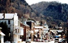
It has a length of five miles in a straight line north and south, but consideraly more, along the Mississippi. Its width is greatest on the northern boundary line, and least on the line between Sections 2 and 11, the corner of Sections 1 and 2, 11 and 12 being close to the Court House, only 6.80 chains from the Mississippi. It is bordered on the West by the river, the course of which at that place is fully described in " Topography." On the Eastside it joins the Towns of Alma and Belvidere, the former of which comes into the actual city on the corner above described, a few lots having been laid out around the Southwest corner of Section 1. On the South the Town of Belvidere also adjoins, while along the Northern boundary line the Town of Nelson extends. For about five miles high and steep bluffs extend, there being no level land between them and the river and sloughs, except the bottoms or islands. The city proper, is situated on the slope of the bluffs, and has but two streets running in the direction of the river, though quite a number crossing them, of which, however, but few are practicable, though some of them have been put into such a condition between Main and Second Streets as to afford communication. Second Street is from 50 to 60 feet above the level of Main Street. The railroad, running close to, or in fact upon part of Main Street in the Lower Addition, it was found necessary to build a graded road from the junction of Main Street with North Street, to the junction of Hill Street with Second Street in order to prevent accidents to teams becoming frightened by the approach of trains. Of the founders of the place a lengthy account has been given in the chapter on Early Settlement and Pioneers. What wa 5 the "Village, and is now the City, of Alma, was part of the Town of Alma, which was organized in March 1856, or rather by the Annual Town meeting and election in April of that year. This election was held at the house of John Marty accordto resolution of the county board. In 1868 it was found desirable to dissolve this connection and the place was incorporated as a village. Owing to some defects in the charter, which could not readily be amended, the citizens applied for a city charter, which was granted by the legislature ot 1885. The first Mayor of the new city "was Martin Polin; he was succeeded by Charles Schaettle, jr. The present Mayor is Hon. John W. DeGroff. The different parts of the city were laid out as follows: Plat of Ahia May 1855, recorded in Vol. 4, page 57. Victor Prohsfs Addition May 6, 1855, recorded in Vol. 4, page 67.
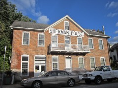
The lives of the pioneers of Twelve Mile Bluff, as the place was called in former times are described in the chapter on Pioneers. After their time others began to arrive. One of the most important families was that of John Marty, consisting of himself and wife and one daughter. The latter was married to W. H. Gates," February 23d, 1856, the second marriage on record. The Martys, John and his brother Nicolas, arrived in 1851. There seems to have been but little activity in any thing until the place was laid .out in lots. The business of the early settlers was making shingles and getting out cordwood. About the same time with the Martys Mathias Hammer, now of Lincoln, arrived. They got their mail from Reeds Landing, Minn., and did all their dealings of store goods at Galena, 111., giving their orders to the steamboat captains, who "would bring the goods on the next trip up the river. The goods needed at that time included provisions of all kinds, flour pork, etc. beside^ articles of clothing and tools for work carried on. The first business opened at Alma was a saloon, kept by a man named Beyer, who had come from Keokuk, and it was located in a shed adjoining the house or shanty of John Marty. In 1855 the following houses were built: By Gates, J. A. Hunner, John Hemrich, Philipp Kraft, J. R. Hurlbuit and E. E. Heerman. They were all along Main Street, above Olive Street, except that of J. R. Hurlburt which was on the corner of Second and . Orange Streets. Hurlburt and Kraft opened hotels, the former the Alma House, the latter the Wisconsin House. The brewery of John Hemrich was also built the same year. ; About a year or perhaps two before that time Rudolf Beiner had arrived and taken lodging in the old shanty built originally b ! V. Probst and J. C. Waecker, and in company with John Marty he laid out the Lower Addition. Most of the above information I have received from Mr. Gates, who was for a long time a prominent citizen of Alma. He was of versatile talents, and undertook a great many things, without, however, achieving any decided success in any particular one. Among other things he kept hotel in both, the Alma House and after that the Sherman House, after the latter had been built. He was elected Register of Deeds in J 857 and Sheriff in 1863. I think he kept the first store in the place in the house on the- corner of
Regional context, not property-specific
evidence. The
federal wildfire occurrence database
lists 12 fires within 5 miles of Frederick Laue Jr. House
between 1993 and 2020, burning about 454 acres in total. None started naturally. 3 were recorded as arson.
Distance is straight-line from the map coordinates, so a fire counted
here may appear on a neighbouring settlement's page as well.
Reported cause
Fires
Debris and open burning
5
Missing data/not specified/undetermined
3
Arson/incendiarism
3
Railroad operations and maintenance
1
The most recent of
them, most recent first, with the day each was reported and the service
that recorded it.
Regional context, not property-specific
evidence. The federal mineral resources record lists
25 workings within 5 miles of Frederick Laue Jr. House: 14 occurrences, 10 past producers, 1 unknown.
None of them still produces. What was taken out: Stone, Crushed/Broken, Sand and Gravel, Construction, Stone, Sand and Gravel, Construction. Distance is straight-line from the
map coordinates, so a quarry counted here may appear on a neighbouring
settlement's page as well.
Regional context, not property-specific
evidence. The National Weather Service names
Alma, the town this property stands in, in 29 storm reports between 1996 and 2023: 14 thunderstorm wind, 9 hail, 3 heavy rain, 2 flash flood.
No death or injury is recorded in these reports. Each account below is quoted exactly as the forecast office
filed it, from the NOAA Storm Events Database, and each date
opens the federal record of that event.
Heavy rain produced a mud slide in the city of Alma that did major damage to one residence, three business, roads and utilities. Significant erosion occurred in Alma as a result of the mud slide.
Trees were blown down and power outages occurred in Alma. In addition, one inch hail covered the ground, damaged vehicles and a cracked at least one windshield.
Significant upstream runoff from the combination of rainfall and melting snow pushed the Mississippi River at Alma into flood stage from April 22nd to April 27th. The crest of 17.05 ft on April 25 was 1.05 ft over flood stage.
No historic map-sheet match is published
for this property yet. That does not mean no map exists. This record needs
a coordinate-quality review before it can be joined to a sheet boundary.
Browse the county's mapped places while that work is
pending.
Listed places nearby
6 within 8 miles
Other National Register properties close
enough to walk or drive between, ordered by distance from this one. Both
positions come from the same geocoding pass that matched these properties
to their map sheets.
Listing record. National Park Service National Register of Historic Places, listed-properties dataset, current to 2026-05-22.
Map join. Address geocoded through the United States Census geocoder, then tested against the published boundary of every sheet in the USGS Historical Topographic Map Collection.
How this page is made. Listing fields come from federal records; map-sheet coverage is a labelled coordinate-to-boundary calculation, not a source-field claim.
Wildfire. Short, Karen C. 2022. Spatial wildfire occurrence data for the United States, 1992-2020 [FPA_FOD_20221014]. 6th Edition. Fort Collins, CO: Forest Service Research Data Archive. https://doi.org/10.2737/RDS-2013-0009.6 Collected with United States Government funding and usable without additional permissions or fees.
Mines and quarries. USGS Mineral Resources Data System (MRDS) https://mrdata.usgs.gov/mrds/ A work of the United States government, no copyright under 17 U.S.C. 105.
Storms. NOAA National Centers for Environmental Information, Storm Events Database https://www.ncei.noaa.gov/stormevents/ A work of the United States government, no copyright under 17 U.S.C. 105. Narratives are quoted verbatim from the National Weather Service report and are not edited or summarised.
 Block