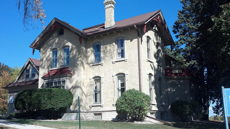
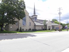
Built in 1876 (Italianate architecture). Listed on the National Register of Historic Places in 1983.
From the record
“William Blair House is located in Waukesha, Wisconsin, United States, and was listed on the National Register of Historic Places in 1983.”
Wikipedia article Sen. William Blair House, CC BY-SA 4.0.
One of 153 National Register listings published here for Waukesha County · listed in 1983 · category: Building · built in 1876, Italianate architecture.
National Register reference number.83004327- the number the National Park Service assigned this property when it was listed, and the key its nomination file is catalogued under at the National Archives.
The twenty-fifth regular session of the legislature began on the loth of January, with a republican majority in both houses. Daniel Hall was elected speaker of the assembly. The next day the governor delivered to a joint convention of the legislature his first annual message - a lengthy document, setting forth in detail the general condition of State affairs. The recent great conflagrations were referred to, and relief suggested. The work of this session of the Legislature was peculiarly difficult, owing to the many general laws which the last constitutional amendment made necessary. The apportionment of the State into new congressional districts was another perplexing and onerous task. Eight districts were formed instead of six, as at the commencement of the last decade. By this, the fourth congressional apportionment, each district elects one member. The first district consists of the counties of Rock, Racine, Kenosha, Walworth, and Waukesha; the second, of Jefferson, Dane, Sauk, and Columbia ; the thirds of Grant, Iowa, LaFayette, Green, Richland, and Crawford ; the fourth, of Milwaukee, Ozaukee, and Washington ; the fifth, of Dodge, Fond du Lac, Sheboygan and Manitowoc ; the sixth, of Green Lake, Waushara, Waupaca, Outagamie, Winnebago, Calumet, Brown, Kewaunee and Door ; the seventh, of Vernon, La Crosse, Monroe, Jackson, Trempealeau, Buffalo, Pepin, Pierce, St. Croix, Eau Claire, and Clark; the eighth, of Oconto, Shawano, Portage, Wood, Juneau, Adams, Marquette, Marathon, Dunn, Chippewa, Barron, Polk, Burnett, Bayfield, Douglas, and Ashland. To this district have since been added the new counties of Lincoln, Taylor, Price, Marinette and New.
At that time, the whole sixty counties of the State stood apportioned in the thirteen judicial circuits as follows: First circuit, Walworth, Racine, and Kenosha; second £Jrcuit, Milwaukee, and Waukesha; third circuit. Green Lake, Dodge, Washington, Ozaukee, and Winnebago; fourth circuit, Sheboygan, Calumet, Kewaunee, Fond du Lac, and Manitowoc ; fifth circuit.
Regional context, not property-specific
evidence. The
federal wildfire occurrence database
lists 18 fires within 5 miles of Sen. William Blair House
between 2018 and 2020, burning about 10 acres in total. None started naturally. 1 was recorded as arson.
Distance is straight-line from the map coordinates, so a fire counted
here may appear on a neighbouring settlement's page as well.
Reported cause
Fires
Missing data/not specified/undetermined
11
Debris and open burning
5
Arson/incendiarism
1
Power generation/transmission/distribution
1
The most recent of
them, most recent first, with the day each was reported and the service
that recorded it.
Regional context, not property-specific
evidence. The federal mineral resources record lists
7 workings within 5 miles of Sen. William Blair House: 4 producers, 2 unknowns, 1 past producer.
4 still produce. What was taken out: Sand and Gravel, Construction, Stone, Stone, Crushed/Broken. Distance is straight-line from the
map coordinates, so a quarry counted here may appear on a neighbouring
settlement's page as well.
Regional context, not property-specific
evidence. The National Weather Service names
Waukesha, the town this property stands in, in 38 storm reports between 1994 and 2006: 16 thunderstorm wind, 8 hail, 5 flood, 4 lightning.
The reports record 1 injury. Each account below is quoted exactly as the forecast office
filed it, from the NOAA Storm Events Database, and each date
opens the federal record of that event.
A man was injured and taken to a hospital after lightning struck very close to him. It is unknown where he was in the city of Waukesha, nor is the exact time known. He was treated and released from the hospital.
A 1-in-a-100-year flood occurred in and around the city of Waukesha after a heavy rain of 3 to 5 inches within a 2-hr period. The heavy rains were the result of slow-moving or back-building thunderstorms that essentially sat over the same area. There were no reports of injuries or deaths. Numerous roads and yards were flooded with water depths of 1 to 5 feet. Many vehicles were stalled in the deep waters or were damaged. There were numerous reports of flooded basements of homes or businesses or apartments. The roof of one business in downtown Waukesha collapsed due to the weight of the heavy rains. The Fox River in downtown Waukesha exceeded its 6-foot flood stage by 6 inches, and then quickly subsided. Some nearby farm fields reported washed out sections and crop losses. The Expo Center sustained damage as well to several of its buildings. The basement of the downtown Waukesha Fire Department flooded to the depth of 5 feet. This flooding was the result of a collapsed trench outside the building where a new addition was under construction. At one point, Waukesha city officials warned motorists to stay away from the city, and some officials thought the July 27th flooding was the worst they could remember. WSR-88D Doppler radar rainfall estimates indicated that up to 5 inches fell over the northwest portion of the city of Waukesha, tapering off to 2 inches on the far south side of the city where STH 59 is located. One unofficial rain gage catch was 4.25 inches on the north side of the city, which matched the radar estimate. It is nearly impossible to assess the monetary amount of the flash flood damage, therefore, the amount posted in the header strip of this event is only a rough estimate.
No historic map-sheet match is published
for this property yet. That does not mean no map exists. This record needs
a coordinate-quality review before it can be joined to a sheet boundary.
Browse the county's mapped places while that work is
pending.
Listed places nearby
6 within 8 miles
Other National Register properties close
enough to walk or drive between, ordered by distance from this one. Both
positions come from the same geocoding pass that matched these properties
to their map sheets.
Listing record. National Park Service National Register of Historic Places, listed-properties dataset, current to 2026-05-22.
Map join. Address geocoded through the United States Census geocoder, then tested against the published boundary of every sheet in the USGS Historical Topographic Map Collection.
How this page is made. Listing fields come from federal records; map-sheet coverage is a labelled coordinate-to-boundary calculation, not a source-field claim.
Wildfire. Short, Karen C. 2022. Spatial wildfire occurrence data for the United States, 1992-2020 [FPA_FOD_20221014]. 6th Edition. Fort Collins, CO: Forest Service Research Data Archive. https://doi.org/10.2737/RDS-2013-0009.6 Collected with United States Government funding and usable without additional permissions or fees.
Mines and quarries. USGS Mineral Resources Data System (MRDS) https://mrdata.usgs.gov/mrds/ A work of the United States government, no copyright under 17 U.S.C. 105.
Storms. NOAA National Centers for Environmental Information, Storm Events Database https://www.ncei.noaa.gov/stormevents/ A work of the United States government, no copyright under 17 U.S.C. 105. Narratives are quoted verbatim from the National Weather Service report and are not edited or summarised.
 Block