 Block
From the record
One of 153 National Register listings published here for Waukesha County · listed in 1983 · category: Building · built in 1879.
Sources: the case file at the National Archives · the National Register database, National Park Service
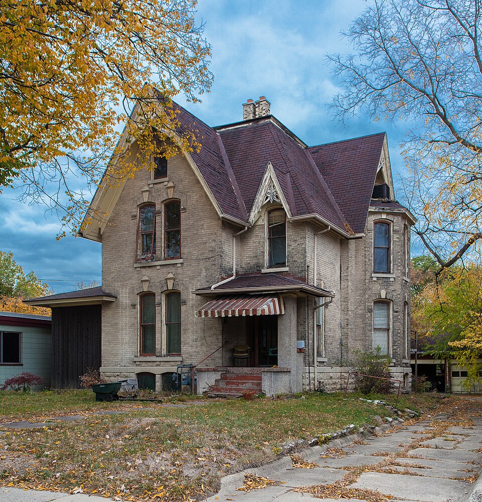
Built in 1879. Listed on the National Register of Historic Places in 1983.
One of 153 National Register listings published here for Waukesha County · listed in 1983 · category: Building · built in 1879.
Sources: the case file at the National Archives · the National Register database, National Park Service
Regional context, not property-specific evidence. The National Weather Service names Waukesha, the town this property stands in, in 38 storm reports between 1994 and 2006: 16 thunderstorm wind, 8 hail, 5 flood, 4 lightning. The reports record 1 injury. Each account below is quoted exactly as the forecast office filed it, from the NOAA Storm Events Database, and each date opens the federal record of that event.
| When | Event | Place named | Harm | What the report says |
|---|---|---|---|---|
| July 2006 | Lightning | Waukesha | 1 hurt | A man was injured and taken to a hospital after lightning struck very close to him. It is unknown where he was in the city of Waukesha, nor is the exact time known. He was treated and released from the hospital. |
| July 2006 | Flash Flood | Waukesha | $3,000,000 | A 1-in-a-100-year flood occurred in and around the city of Waukesha after a heavy rain of 3 to 5 inches within a 2-hr period. The heavy rains were the result of slow-moving or back-building thunderstorms that essentially sat over the same area. There were no reports of injuries or deaths. Numerous roads and yards were flooded with water depths of 1 to 5 feet. Many vehicles were stalled in the deep waters or were damaged. There were numerous reports of flooded basements of homes or businesses or apartments. The roof of one business in downtown Waukesha collapsed due to the weight of the heavy rains. The Fox River in downtown Waukesha exceeded its 6-foot flood stage by 6 inches, and then quickly subsided. Some nearby farm fields reported washed out sections and crop losses. The Expo Center sustained damage as well to several of its buildings. The basement of the downtown Waukesha Fire Department flooded to the depth of 5 feet. This flooding was the result of a collapsed trench outside the building where a new addition was under construction. At one point, Waukesha city officials warned motorists to stay away from the city, and some officials thought the July 27th flooding was the worst they could remember. WSR-88D Doppler radar rainfall estimates indicated that up to 5 inches fell over the northwest portion of the city of Waukesha, tapering off to 2 inches on the far south side of the city where STH 59 is located. One unofficial rain gage catch was 4.25 inches on the north side of the city, which matched the radar estimate. It is nearly impossible to assess the monetary amount of the flash flood damage, therefore, the amount posted in the header strip of this event is only a rough estimate. |
| June 1997 | Lightning | Waukesha | $150,000 | no account filed |
| August 2004 | Lightning | Waukesha | $100,000 | no account filed |
| July 2000 | Thunderstorm Wind | Waukesha | $100,000 | no account filed |
| September 2000 | Flash Flood | Waukesha | $50,000 | no account filed |
| April 1994 | Thunderstorm Wind | Waukesha | $50,000 | no account filed |
| August 2004 | Thunderstorm Wind | Waukesha | $20,000 | no account filed |
| August 2002 | Flash Flood | Waukesha | $20,000 | no account filed |
| May 1998 | Thunderstorm Wind | Waukesha | $15,000 | no account filed |
| July 2005 | Thunderstorm Wind | Waukesha | $10,000 | Thunderstorm wind gusts of hurricane force caused scattered areas of large tree damage from the Waukesha area northeast to Brookfield. |
| June 1998 | Lightning | Waukesha | $6,000 | Lightning ignited a fire in the attic of a home. |
| September 2000 | Thunderstorm Wind | Waukesha | $3,000 | no account filed |
| June 1997 | Thunderstorm Wind | Waukesha | $3,000 | no account filed |
| July 2000 | Thunderstorm Wind | Waukesha | $2,000 | no account filed |
| June 1999 | Thunderstorm Wind | Waukesha | $1,000 | no account filed |
| June 1999 | Thunderstorm Wind | Waukesha | $1,000 | no account filed |
| August 2004 | Dust Devil | Waukesha | $200 | no account filed |
| July 2006 | Thunderstorm Wind | Waukesha | - | Trees down. |
| April 2006 | Hail | Waukesha | - | no account filed |
| May 2004 | Hail | Waukesha | - | no account filed |
| November 2003 | Heavy Rain | Waukesha | - | no account filed |
| July 2003 | Thunderstorm Wind | Waukesha | - | no account filed |
| July 2003 | Thunderstorm Wind | Waukesha | - | no account filed |
| July 2002 | Flood | Waukesha | - | no account filed |
| August 2002 | Flood | Waukesha | - | no account filed |
| August 2002 | Thunderstorm Wind | Waukesha | - | no account filed |
| August 2002 | Flood | Waukesha | - | no account filed |
| August 2001 | Thunderstorm Wind | Waukesha | - | no account filed |
| May 2000 | Hail | Waukesha | - | no account filed |
| May 2000 | Hail | Waukesha | - | no account filed |
| May 2000 | Hail | Waukesha | - | no account filed |
| July 2000 | Flood | Waukesha | - | no account filed |
| July 1999 | Flood | Waukesha | - | no account filed |
| July 1999 | Hail | Waukesha | - | no account filed |
| September 1998 | Hail | Waukesha | - | no account filed |
| July 1994 | Thunderstorm Wind | Waukesha | - | no account filed |
| July 1994 | Hail | Waukesha | - | no account filed |
No historic map-sheet match is published for this property yet. That does not mean no map exists. This record needs a coordinate-quality review before it can be joined to a sheet boundary. Browse the county's mapped places while that work is pending.
| National Archives record | The nomination case file for reference 83004341 in Record Group 79. |
| Waukesha County | All 153 listed properties in this county. |