
BlockBefore

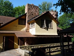
Bowman House

Built in 1904 (Prairie School architecture). Listed on the National Register of Historic Places in 1986.

From the record

“The Bowman House is a historic house located at 714 Broadway Street in Wisconsin Dells, Wisconsin. The Prairie School house was built in 1904 for Abram and Alberta Bowman.”

Wikipedia article Bowman House (Wisconsin Dells, Wisconsin), CC BY-SA 4.0.

One of 55 National Register listings published here for Columbia County · listed in 1986 · category: Building · built in 1904, Prairie School architecture.

Sources: the Wikipedia article · the case file at the National Archives · the National Register database, National Park Service · the Wikipedia article

The listing

  • What is counted as historic. The nomination lists 2 buildingss as contributing to the listing.
  • Address. 714 Broadway St., Wisconsin Dells, 53965
  • When was it listed? April 1986
  • Category. building
  • City. Wisconsin Dells city
  • When was it built? 1904
  • Architectural style. Prairie School architecture
  • National Register reference number. 86000621 - the number the National Park Service assigned this property when it was listed, and the key its nomination file is catalogued under at the National Archives.

Fires near this property

286 since 1992

Regional context, not property-specific evidence. The federal wildfire occurrence database lists 286 fires within 5 miles of Bowman House between 1992 and 2020, burning about 257 acres in total. 3 started naturally. 15 were recorded as arson. Distance is straight-line from the map coordinates, so a fire counted here may appear on a neighbouring settlement's page as well.

Reported cause Fires
Debris and open burning83
Equipment and vehicle use70
Missing data/not specified/undetermined51
Arson/incendiarism15
Power generation/transmission/distribution12
Railroad operations and maintenance12
Fireworks10
Smoking9
Misuse of fire by a minor8
Other causes8
Recreation and ceremony5
Natural3

The most recent of them, most recent first, with the day each was reported and the service that recorded it.

DateCause SizeReported by Name on the report
6 September 2001Power generation/transmission/distributionunder an acreWisconsin Department of Natural Resourcesnot named
6 September 1996Missing data/not specified/undeterminedunder an acreWisconsin Department of Natural Resourcesnot named
5 September 1998Equipment and vehicle useunder an acreWisconsin Department of Natural Resourcesnot named
2 September 2019Equipment and vehicle useunder an acreWisconsin Department of Natural ResourcesHIGHWAY 13-2
2 September 2019Equipment and vehicle useunder an acreWisconsin Department of Natural ResourcesHIGHWAY 13-1
13 September 1998Debris and open burningunder an acreWisconsin Department of Natural Resourcesnot named
7 August 2009Power generation/transmission/distributionunder an acreWisconsin Department of Natural ResourcesSQUIRREL
4 August 2015Missing data/not specified/undeterminedunder an acreWisconsin Department of Natural ResourcesHIGHWAY 12 CHURCHYARD

Every fire recorded in Columbia County

Mines and quarries near this property

5 within 5 miles

Regional context, not property-specific evidence. The federal mineral resources record lists 5 workings within 5 miles of Bowman House: 2 past producers, 2 unknowns, 1 producer. 1 still produces. What was taken out: Sand and Gravel, Construction. Distance is straight-line from the map coordinates, so a quarry counted here may appear on a neighbouring settlement's page as well.

Where SiteCommodity StatusRecorded
Cummings PitSand and Gravel, ConstructionUnknown
Dubois PitSand and Gravel, ConstructionProducer
Kettleson PitSand and Gravel, ConstructionUnknown
Kettleson PitSand and Gravel, ConstructionPast Producer
Macksey PitSand and Gravel, ConstructionPast Producer

Every working recorded in Columbia County

Storms near this property

27 since 1994

Regional context, not property-specific evidence. The National Weather Service names Wisconsin Dells, the town this property stands in, in 27 storm reports between 1994 and 2023: 17 thunderstorm wind, 6 hail, 2 flash flood, 1 tornado. No death or injury is recorded in these reports. Each account below is quoted exactly as the forecast office filed it, from the NOAA Storm Events Database, and each date opens the federal record of that event.

WhenEvent Place namedHarm What the report says
September 2010FloodWisconsin Dells$1,230,000The river at the gage in Portage was in flood from the evening of September 24th through the morning of September 30th, and reached a record flood level of 20.66 feet during the evening of Monday, September 27th. The old record crest at Portage was 20.50 feet on 09/14/1938. The flood waters threatened to break through a century-old earthen dike in the Civil Township of Caledonia. The waters seeped through the dike, but the dike did not fail. The potential levee failures caused voluntary evacuations and road closures along the river from the Dells to Portage. As it turned out, dozens of homes in the Blackhawk Park area just southeast of Portage were cut off when water depths reached a foot on the only road into the area. The Columbia County Emergency Management Director provided the following loss estimates: $1 M for seasonal and full-time residental homes, $100,000 for patching and reinforcing part of a 14-mile earthen berm/dike, $50,000 for gravel shoulder washouts, $75,000 to a wastwater treatment plant, and $200,000 to bottomland crops. It was postulated that damage was limited due to the fact that the flood waters rose slowly which reduced the erosional power of water. The EM Director also noted that the Wisconsin River levels in Portage were about a foot higher than that experienced in the Great Flood of 1993, while at Wisconsin Dells the 2010 level was about a foot lower than that experienced in 1993.
June 2006Tornado (F1)Wisconsin Dells$400,000The first segment of a multi-county-segmented tornado spun up 3.0 miles east of Wisconsin Dells at 1754CST about 0.6 mile east-northeast of the intersection of Broadway Rd. and CTH Q. It headed southeast and crossed STH 16 at Lewiston, and then crossed the Wisconsin River into Sauk County about 1.5 miles southeast of Lewiston at 1813CST. In this first Columbia County stretch, around 10 houses were damaged or destroyed, along with a couple pole sheds and many trees and power lines. An estimated 400,000 dollars in property damage occurred. The tornado was rated F1 with winds of 64 to 97 knots (73-112 mph). After a short track through Sauk County, this tornado re-entered Columbia County about 7 miles west of Portage, crossed Interstate 90/94, and then crossed the Wisconsin River again before dissipating at 1840CST.
August 2020Flash FloodWisconsin Dells$100,000Many roads impassible in Portage from flash flooding. Many vehicles stranded or flowing within the deep floodwaters with several water rescues executed. Also, yards and basements flooded in Portage. Elsewhere in northern Columbia County, road and culvert washouts on highway P east of Pardeeville, and in the townships of Fort Winnebago and Lewiston. Rising waters on Swan Lake flooded out some homes on the northwest side of the lake. Portions of the Fox River flooded from northeast Columbia County to Pardeeville. The Fox River floodwaters flooded a portion of highway 44 northeast of Marcellon. The Pardeeville DPW sandbagged the sanitary sewer manholes to reduce the constant running of the lift stations.
May 2012Thunderstorm WindWisconsin Dells$30,000Law enforcement officials reported many trees and power lines downed by powerful thunderstorm wind gusts, estimated up to 75 mph (65 knots) in the Wisconsin Dells. Four cars were also damaged, with overall property damages estimated to be $30,000 dollars.
June 2008Thunderstorm WindWisconsin Dells$30,000Powerful thunderstorm winds knocked down large trees and power-lines, and also knocked over a temporary canopy.
July 2010Thunderstorm WindWisconsin Dells$20,000A trained spotter reported trees and power lines blown down by thunderstorm wind gusts estimated at 70 mph (61 knots) along a path from the Wisconsin Dells to Portage.
August 2004Flash FloodWisconsin Dells$15,000no account filed
July 2023Thunderstorm WindWisconsin Dells$8,000Dozens and trees and branches down in the same direction.
May 2012HailWisconsin Dells$5,000A ten-minute shower of large hail from a severe thunderstorm broke windows, with the damage totaling $5,000.
September 2007Thunderstorm WindWisconsin Dells$5,000Powerful thunderstorm downburst winds gusting to an estimated 65 knots (75 mph) toppled several large trees. Tree branch debris knocked down some power lines. The winds lifted one side of a trained spotters's vehicle about 6 inches into the air.
May 2007Thunderstorm WindWisconsin Dells$5,000Large trees were uprooted across the city of Wisconsin Dells.
August 2007Thunderstorm WindWisconsin Dells$5,000Powerful thunderstorm wind gusts to around 52 knots (60 mph) toppled saeveral large trees and a power-pole/power-line.
July 2023Thunderstorm WindWisconsin Dells$3,000Large branches around 4-6 inches snapped.
June 1997Thunderstorm WindWisconsin Dells$3,000no account filed
June 2020Thunderstorm WindWisconsin Dells$2,000Several large trees down in WI Dells.
June 1999Thunderstorm WindWisconsin Dells$2,000no account filed
March 2000HailWisconsin Dells$1,000no account filed
July 1994Thunderstorm WindWisconsin Dells$500no account filed
July 2021Thunderstorm WindWisconsin Dells-no account filed
July 2006HailWisconsin Dells-no account filed
July 2006Thunderstorm WindWisconsin Dells-no account filed
August 2003Thunderstorm WindWisconsin Dells-no account filed
August 2003HailWisconsin Dells-no account filed
June 2001HailWisconsin Dells-no account filed
June 2001Thunderstorm WindWisconsin Dells-no account filed

Every storm recorded in Columbia County

Map coverage status

No historic map-sheet match is published for this property yet. That does not mean no map exists. This record needs a coordinate-quality review before it can be joined to a sheet boundary. Browse the county's mapped places while that work is pending.

Listed places nearby

4 within 8 miles

Other National Register properties close enough to walk or drive between, ordered by distance from this one. Both positions come from the same geocoding pass that matched these properties to their map sheets.

Photograph PropertyDistance Listed
Kilbourn Public Library0.2 miles1974
Jacob Weber House0.4 miles1978
H. H. Bennett Studio0.4 miles1976
Wawbeek-Horace A.J. Upham House0.8 miles1985

Sources for this property

National Archives recordThe nomination case file for reference 86000621 in Record Group 79.
Wikipedia articleCommunity-written account of this property, licensed CC BY-SA.
Columbia CountyAll 55 listed properties in this county.

Provenance

  • Listing record. National Park Service National Register of Historic Places, listed-properties dataset, current to 2026-05-22.
  • Map join. Address geocoded through the United States Census geocoder, then tested against the published boundary of every sheet in the USGS Historical Topographic Map Collection.
  • How this page is made. Listing fields come from federal records; map-sheet coverage is a labelled coordinate-to-boundary calculation, not a source-field claim.
  • Wildfire. Short, Karen C. 2022. Spatial wildfire occurrence data for the United States, 1992-2020 [FPA_FOD_20221014]. 6th Edition. Fort Collins, CO: Forest Service Research Data Archive. https://doi.org/10.2737/RDS-2013-0009.6 Collected with United States Government funding and usable without additional permissions or fees.
  • Mines and quarries. USGS Mineral Resources Data System (MRDS) https://mrdata.usgs.gov/mrds/ A work of the United States government, no copyright under 17 U.S.C. 105.
  • Storms. NOAA National Centers for Environmental Information, Storm Events Database https://www.ncei.noaa.gov/stormevents/ A work of the United States government, no copyright under 17 U.S.C. 105. Narratives are quoted verbatim from the National Weather Service report and are not edited or summarised.