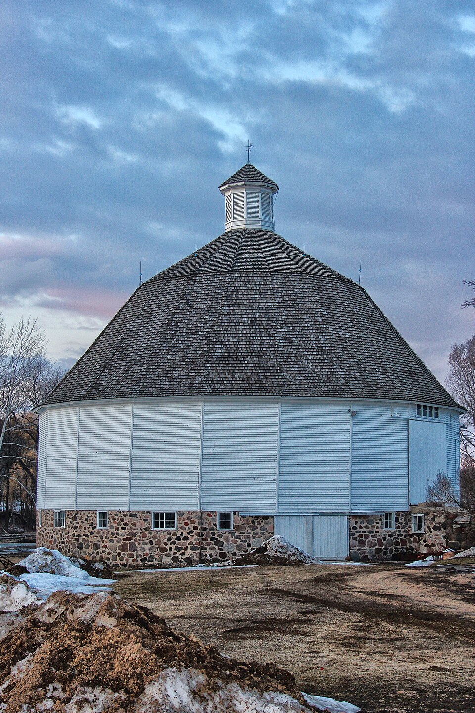
Built in 1911. Listed on the National Register of Historic Places in 1988.
From the record
“The Nashold 20-sided Barn is a round barn in Fountain Prairie, Wisconsin. The barn was built in 1911, at which time round barns were a popular agricultural innovation.”
Wikipedia article Nashold 20-sided Barn, CC BY-SA 4.0.
One of 55 National Register listings published here for Columbia County · listed in 1988 · category: Building · built in 1911.
National Register reference number.88000091- the number the National Park Service assigned this property when it was listed, and the key its nomination file is catalogued under at the National Archives.
O. W. FIELD, farmer. Sec. 16; P. 0. Fall River; 280 acres, 170 acres cultivated; born in Onondaga Co., N. Y.; son of Stephen and Charlotte (Berry) Fields; went to Michigan, Kalamazoo Co., at the age of 5 years, with parents, remained there sixteen years and then came here. Married in this town, October, 1863, to Maria N. Smith, daughter of Lewis and Sylvina (_Webb) Smith ; had .six children - Mary E., born Sept. 26, 1864 ; Maud E., born April 6, 1866 ; George S., born Dec. 8, 1868 ; Oliver West, born Feb. 20, 1871 ; Edwin P., born April 25, 1873 ; Lewis G., born Sept. 10, 1877. Mr. Fields is a Republican ; seven years Supervisor, one year Chairman and fourteen years Treasurer of his School District ; his father was in Springfield armory during war of 1812.
NHELDEN E. HE WIIVS, farmer, Sec 29; P. 0. Fall River ; born in Massachusetts in, 1834; son of Elijah and Sabia A. (Wooster) Hewins ; went to Lorain Co., Ohio, with parents at 18 months of age, where he lived 10 years; then to Byron, Fond du Lac Co., Wis., and, at 14 years of age, came to this town. Married, Jan. 15, 1856, at Byron, by Elder Harrington, to AJolia A., daughter of Chestes and Olive (Ingals) Thomas; wife born March 13, 1839; had four children - Frank K., born Oct. 0, 1850 ; Wilbur F., Dec, 21, 1863 ; Mjrtie A., March 4, 1871 ; Homer E., Dec. 5, 1872. Republican in politics; Baptist in religion. Has a well-cultivated farm of 216 acres. His brother, George W., wa.s in Go. E, 3d W. V. I., and had his arm shot off at the shoulder-joint at the battle of Beverly's Ford ; be came home, and, while boarding with Mr. McCoy, in the Lower Town in the city of Fond du Lac, Wis., was accidentally burned to death on the night of Sept. 8, 1878, the house being totally destroyed with its contents; all the inmates escaped except Hewins, and he, being disabled, perished in the flames; strong suspicion.s of foul play were generally entertained at that time ( he having lately drawn his pension), but the case was never fully investigated. Hi.s brother, Edwin M., wa.s in the 2d Kan. V. C.; was wounded, now lives in Chautau(|ua Co., Kan. Edwin M. and Eliza Shepard, now the wife of Mr. Sweet, were, about July, 1847, lost in the woods in Fond du Lac Co., and remained three dajs with nothing to eat, except the few berries they could find ; they were discovered only six miles from home, nearly famished. The father of Mr. Hewins kept the Crescent House at Appleton three years, and went to California April 5, 1853; returned March 11, five years later, and died at Pickett's Station three days after, being unconsciou.s, as reported, from the effect of apoplexy ; it was strongly suspected, however, that his death was the result of other causes, as he was in po.ssession of considerable money when he left.
Regional context, not property-specific
evidence. The
federal wildfire occurrence database
lists 104 fires within 5 miles of Nashold 20-sided Barn
between 1992 and 2020, burning about 497 acres in total. None started naturally. 5 were recorded as arson.
Distance is straight-line from the map coordinates, so a fire counted
here may appear on a neighbouring settlement's page as well.
Reported cause
Fires
Debris and open burning
49
Equipment and vehicle use
31
Missing data/not specified/undetermined
11
Arson/incendiarism
5
Smoking
3
Railroad operations and maintenance
2
Other causes
1
Misuse of fire by a minor
1
Recreation and ceremony
1
The most recent of
them, most recent first, with the day each was reported and the service
that recorded it.
Regional context, not property-specific
evidence. The federal mineral resources record lists
2 workings within 5 miles of Nashold 20-sided Barn: 1 past producer, 1 unknown.
None of them still produces. What was taken out: Stone, Crushed/Broken, Stone. Distance is straight-line from the
map coordinates, so a quarry counted here may appear on a neighbouring
settlement's page as well.
Regional context, not property-specific
evidence. The National Weather Service names
Fall River, the town this property stands in, in 12 storm reports between 1999 and 2024: 4 thunderstorm wind, 4 hail, 3 tornado, 1 flood.
No death or injury is recorded in these reports. Each account below is quoted exactly as the forecast office
filed it, from the NOAA Storm Events Database, and each date
opens the federal record of that event.
A culvert partially undermined by floodwaters on County Highway DG northeast of Fall River. A washed out shoulder northbound on Highway 146 south of Cambria.
This was 1 of 17 tornadoes to occur in Wisconsin on the night of July 28th into the early morning hours of July 29th. This was the 8th overall tornado for the event.|A line of storms developed in northern Wisconsin and pushed south into southern Wisconsin in the overnight hours of the 28th into the 29th of July with mainly brief tornadoes and damaging winds occurring. ||This tornado began and ended on one property northwest of Columbus, just west of Highway 16 and south of Hall Rd. This brief tornado did tree and crop damage.
This weak tornado started in Columbia County, northeast of the village of Fall River near the county line, just northwest of the intersection of Raven Road and Hemling Road. It moved southeastward and crossed into Dodge County where a creek crosses the county line just southeast of Paul Road. Minor tree damage was noted in Columbia County. The starting and ending locations for the Columbia County segment, with respect to lat/long pairs of numbers, were 43.41413/-89.01782 and 43.41086/-89.00504. DI#27 (TH), DOD2. Wind speeds estimated at 65 mph. Average path width was about 15 yards.
A tornado spun up very briefly at 1825 CST, 2 miles southwest of Fall River in Columbia County. A storm survey determined the tornado's path was only a tenth of a mile and the width was about 25 yards. Its estimated position is about 0.3 mile west-northwest of the intersection of Hall Rd. and Freck Rd. No damage was reported and it was determined the tornado was an F0.
No historic map-sheet match is published
for this property yet. That does not mean no map exists. This record needs
a coordinate-quality review before it can be joined to a sheet boundary.
Browse the county's mapped places while that work is
pending.
Listed places nearby
6 within 8 miles
Other National Register properties close
enough to walk or drive between, ordered by distance from this one. Both
positions come from the same geocoding pass that matched these properties
to their map sheets.
Listing record. National Park Service National Register of Historic Places, listed-properties dataset, current to 2026-05-22.
Map join. Address geocoded through the United States Census geocoder, then tested against the published boundary of every sheet in the USGS Historical Topographic Map Collection.
How this page is made. Listing fields come from federal records; map-sheet coverage is a labelled coordinate-to-boundary calculation, not a source-field claim.
Wildfire. Short, Karen C. 2022. Spatial wildfire occurrence data for the United States, 1992-2020 [FPA_FOD_20221014]. 6th Edition. Fort Collins, CO: Forest Service Research Data Archive. https://doi.org/10.2737/RDS-2013-0009.6 Collected with United States Government funding and usable without additional permissions or fees.
Mines and quarries. USGS Mineral Resources Data System (MRDS) https://mrdata.usgs.gov/mrds/ A work of the United States government, no copyright under 17 U.S.C. 105.
Storms. NOAA National Centers for Environmental Information, Storm Events Database https://www.ncei.noaa.gov/stormevents/ A work of the United States government, no copyright under 17 U.S.C. 105. Narratives are quoted verbatim from the National Weather Service report and are not edited or summarised.
 Block