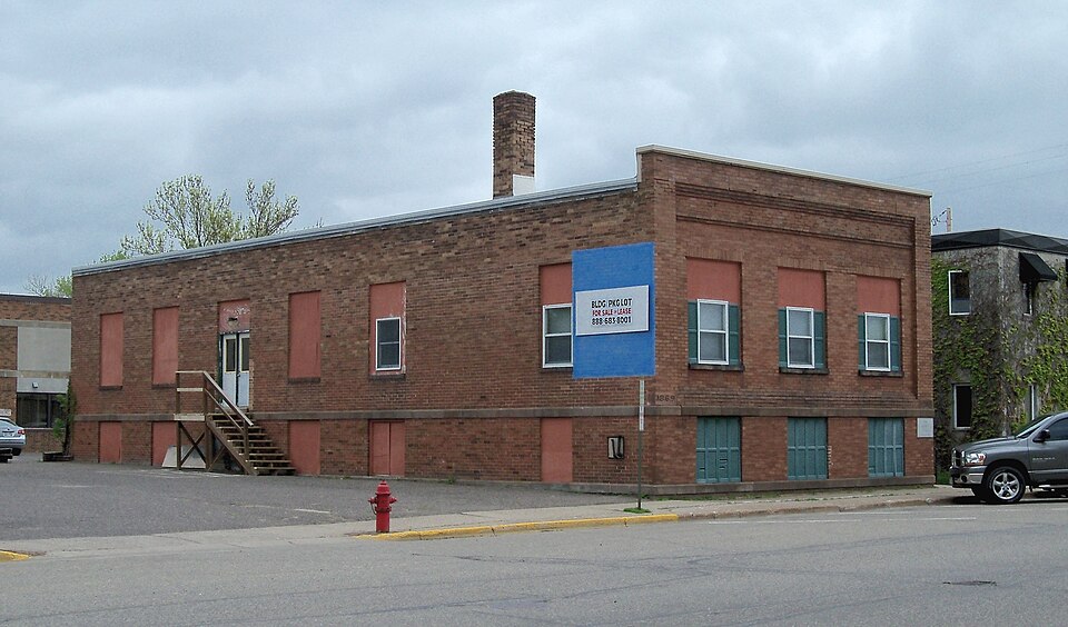
Built in 1913. Listed on the National Register of Historic Places in 1988.
From the record
“The New Richmond News Building is a historic building located at 154 Second Street in New Richmond, Wisconsin. It was built in 1913, and was added to the National Register of Historic Places in 1988.”
Wikipedia article New Richmond News Building, CC BY-SA 4.0.
One of 34 National Register listings published here for St. Croix County · listed in 1988 · category: Building · built in 1913.
National Register reference number.88000625- the number the National Park Service assigned this property when it was listed, and the key its nomination file is catalogued under at the National Archives.
Fires near this property
29 since 2012
Regional context, not property-specific
evidence. The
federal wildfire occurrence database
lists 29 fires within 5 miles of New Richmond News Building
between 2012 and 2020, burning about 18 acres in total. None started naturally. 2 were recorded as arson.
Distance is straight-line from the map coordinates, so a fire counted
here may appear on a neighbouring settlement's page as well.
Reported cause
Fires
Missing data/not specified/undetermined
14
Debris and open burning
7
Recreation and ceremony
5
Arson/incendiarism
2
Equipment and vehicle use
1
The most recent of
them, most recent first, with the day each was reported and the service
that recorded it.
Regional context, not property-specific
evidence. The federal mineral resources record lists
20 workings within 5 miles of New Richmond News Building: 9 past producers, 6 occurrences, 4 producers, 1 unknown.
4 still produce. What was taken out: Sand and Gravel, Construction, Limestone, Dimension, Stone, Crushed/Broken. Distance is straight-line from the
map coordinates, so a quarry counted here may appear on a neighbouring
settlement's page as well.
Regional context, not property-specific
evidence. The National Weather Service names
New Richmond, the town this property stands in, in 37 storm reports between 1996 and 2025: 21 hail, 14 thunderstorm wind, 1 lightning, 1 tornado.
No death or injury is recorded in these reports. Each account below is quoted exactly as the forecast office
filed it, from the NOAA Storm Events Database, and each date
opens the federal record of that event.
A large swath of severe thunderstorm wind damage occurred from just west of New Richmond to the Glenwood City area, as determined by a National Weather Service damage survey. This swath of damage occurred within an approximately two to four mile width between these two cities. Numerous reports of damage were provided by the St. Croix County emergency manager, trained spotters, amateur radio operators and law enforcement. The New Richmond Airport AWOS also measured 60 knots at 2043 CST (two hangars were damaged). Some general reports include: 109 homes damaged or severely damaged, 48 barns damaged or severely damaged. In New Richmond, many 6 inch diameter or larger trees reported felled, and some light poles down throughout New Richmond; some roads were impassable due to downed trees; railroad crossing arms bent over at crossing. Some barns with significant damage reported on 140th Ave. (at residence numbers: 1703, 1793, 2540, 2578 and 2583). A roof torn off or other damages were reported on 160th St. (at residence numbers: 1593, 1769 and 1793), along with 1248 290th St. The back of a house was reported torn away at 2540 140th Ave., with another home damaged at 1506 County Road G. In Glenwood City, one to two foot diameter trees were reported down along with power lines. Two barns were reported destroyed near Emerald. A house was also rendered uninhabitable three miles east-southeast of New Richmond. One home at County G and GG was completely destroyed. Sheriff Dennis Hillstead said damage county wide was significant,and that it had been 10 to 12 years since the county had seen such widespread damage. The Luckwaldt Dairy north of Woodville received heavy damage, including ripping aprt the canvas covering to the barn. One cow was also lost. Significant damage was also reported at the Emeral Dairy in Emerald. Near Emerald Dairy, along county Highway G, barns, homes and corn fields were flattened. Power lines and trees were also toppled. The entire village of Hammond and some outlying areas were without power for approximately 12 hours Tuesday morning. Significant damage to Xcel Energy's electrical grid was reported during the early morning storms. A total of 24 transmission poles were broken or damaged and needed to be replaced across the Western Wisconsin. At the peak of the storm about 20,000 customers in western Wisconsin lost power from both high winds and lightning strikes. As reported by the following newspapers: Baldwin Bulletin, Hudson Star-Observer, County Today, Central St. Croix News, and the Courier Wedge.
About one dozen homes were damaged, mostly due to some shingles, soffits or siding being torn off. One house, however, had windows blown in and had partial roof damage. It also had a garage that was completely blown apart and destroyed, but the garage had been added on and was not part of the original house itself. Another house had damage to its front porch overhang, which allowed wind to enter the attic and punch a hole through the roof on the backside of the house. At a farm, an old barn collapsed. At another house, part of the roof was blown off a machine shed.
Several reports of hail up to 1.75 inches in diameter within the city of New Richmond along WI-65. The largest hail was reported near the intersection of East Richmond Way and 140th Street.
Metal bleachers at the New Richmond High School were blown into a fence. Several trees were also blown down. New Richmond Airport also measured a wind gust of 51 mph, and a home weather station near New Richmond measured a 57 mph wind gust.
No historic map-sheet match is published
for this property yet. That does not mean no map exists. This record needs
a coordinate-quality review before it can be joined to a sheet boundary.
Browse the county's mapped places while that work is
pending.
Listed places nearby
6 within 8 miles
Other National Register properties close
enough to walk or drive between, ordered by distance from this one. Both
positions come from the same geocoding pass that matched these properties
to their map sheets.
Listing record. National Park Service National Register of Historic Places, listed-properties dataset, current to 2026-05-22.
Map join. Address geocoded through the United States Census geocoder, then tested against the published boundary of every sheet in the USGS Historical Topographic Map Collection.
How this page is made. Listing fields come from federal records; map-sheet coverage is a labelled coordinate-to-boundary calculation, not a source-field claim.
Wildfire. Short, Karen C. 2022. Spatial wildfire occurrence data for the United States, 1992-2020 [FPA_FOD_20221014]. 6th Edition. Fort Collins, CO: Forest Service Research Data Archive. https://doi.org/10.2737/RDS-2013-0009.6 Collected with United States Government funding and usable without additional permissions or fees.
Mines and quarries. USGS Mineral Resources Data System (MRDS) https://mrdata.usgs.gov/mrds/ A work of the United States government, no copyright under 17 U.S.C. 105.
Storms. NOAA National Centers for Environmental Information, Storm Events Database https://www.ncei.noaa.gov/stormevents/ A work of the United States government, no copyright under 17 U.S.C. 105. Narratives are quoted verbatim from the National Weather Service report and are not edited or summarised.
 Block