 Block
From the record
One of 33 National Register listings published here for Marathon County · listed in 1992 · category: Building · built in 1875.
Sources: the case file at the National Archives · the National Register database, National Park Service
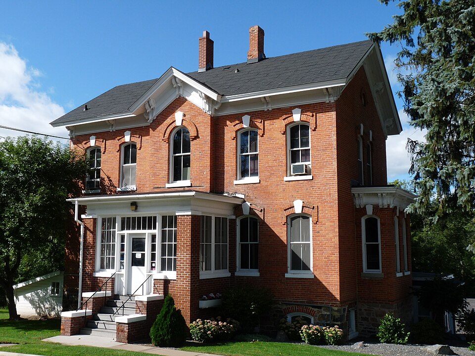
Built in 1875. Listed on the National Register of Historic Places in 1992.
One of 33 National Register listings published here for Marathon County · listed in 1992 · category: Building · built in 1875.
Sources: the case file at the National Archives · the National Register database, National Park Service
The chapter on Marathon City Village in History of Marathon County, Wisconsin and Representative Citizens, published 1913 names Marathon. This is what it says, exactly as the scans read.
The history of Marathon City is really the history of the first settlement by the Pittsburg Settlers' Club, and of the towns of Marathon and Cassel. The village was platted and the plat recorded on June 8, 1858. The surveyor who laid it out was W. B. Agnew of Stevens Point, where the United States Land Office was located where the lands were purchased by a committee of the club, as referred to under Chapter of Early Settlements. This plat was later corrected by judicial proceedings and re-recorded June 12, 1884.
Passage source: History of Marathon County, Wisconsin and Representative Citizens, published 1913.
Sunday was a day of rest and devotion. The settlers assembled in church for service, coming from one to twelve miles, from the present towns of Marathon, Cassel, and Wien. The family coming furthest to church were the Hornungs, living in section 4 in the present town of Wien. As late as 1867 there were but a few houses in what is now the village.
Passage source: History of Marathon County, Wisconsin and Representative Citizens, published 1913.
Machine-read from a century-old scan, so expect the errors a machine makes: misspelled names, dropped words, stray characters.
Read the whole chapter on Marathon City Village - 4,799 words on its settlement, mills, schools and churches.
Regional context, not property-specific evidence. The federal wildfire occurrence database lists 10 fires within 5 miles of Fricke-Menzner House between 1993 and 2020, burning about 9 acres in total. None started naturally. 1 was recorded as arson. Distance is straight-line from the map coordinates, so a fire counted here may appear on a neighbouring settlement's page as well.
| Reported cause | Fires |
|---|---|
| Equipment and vehicle use | 3 |
| Missing data/not specified/undetermined | 2 |
| Debris and open burning | 2 |
| Misuse of fire by a minor | 1 |
| Smoking | 1 |
| Arson/incendiarism | 1 |
The most recent of them, most recent first, with the day each was reported and the service that recorded it.
| Date | Cause | Size | Reported by | Name on the report |
|---|---|---|---|---|
| 3 June 1997 | Equipment and vehicle use | under an acre | Wisconsin Department of Natural Resources | not named |
| 5 April 2020 | Missing data/not specified/undetermined | under an acre | Wisconsin Department of Natural Resources | 2004004 |
| 25 April 1997 | Debris and open burning | under an acre | Wisconsin Department of Natural Resources | not named |
| 23 April 1994 | Misuse of fire by a minor | 2.6 acres | Wisconsin Department of Natural Resources | not named |
| 17 April 1994 | Equipment and vehicle use | under an acre | Wisconsin Department of Natural Resources | not named |
| 14 April 2009 | Arson/incendiarism | under an acre | Great Lakes Agency | 542 WASWAGON |
| 30 March 2010 | Equipment and vehicle use | under an acre | Wisconsin Department of Natural Resources | PACKER DRIVE |
| 30 November 2007 | Missing data/not specified/undetermined | 4.5 acres | Wisconsin Department of Natural Resources | not named |
Regional context, not property-specific evidence. The federal mineral resources record lists 34 workings within 5 miles of Fricke-Menzner House: 17 occurrences, 14 past producers, 3 producers. 3 still produce. What was taken out: Sand and Gravel, Construction, Stone, Crushed/Broken, Stone, REE, Thorium, Zirconium, Tantalum, Niobium (Columbium), Hafnium. Distance is straight-line from the map coordinates, so a quarry counted here may appear on a neighbouring settlement's page as well.
| Where | Site | Commodity | Status | Recorded |
|---|---|---|---|---|
| County Concrete, Inc. | Stone | Producer | ||
| Wausau Area | REE, Thorium, Zirconium, Tantalum, Niobium (Columbium), Hafnium | Occurrence | ||
| Alfred Krahn Granite Deposit | Stone, Crushed/Broken | Occurrence | ||
| Bobwhite Lane Granite Deposit | Stone, Crushed/Broken | Occurrence | ||
| J Schmidt Granite Deposit | Stone, Crushed/Broken | Occurrence | ||
| Pet Brook Granite Deposit #2 | Stone, Crushed/Broken | Occurrence | ||
| Roger Ross Granite Quarry | Stone, Crushed/Broken | Past Producer | ||
| Szymanski Granite Deposit | Stone, Crushed/Broken | Occurrence | ||
| Allenhofen Gravel Pit #1 | Sand and Gravel, Construction | Past Producer | ||
| Allenhofen Gravel Pit #2 | Sand and Gravel, Construction | Past Producer |
Regional context, not property-specific evidence. The National Weather Service names Marathon, the town this property stands in, in 23 storm reports between 1997 and 2025: 10 hail, 8 thunderstorm wind, 2 tornado, 1 funnel cloud. No death or injury is recorded in these reports. Each account below is quoted exactly as the forecast office filed it, from the NOAA Storm Events Database, and each date opens the federal record of that event.
| When | Event | Place named | Harm | What the report says |
|---|---|---|---|---|
| March 2016 | Flood | Marathon | $10,000 | Runoff from at least two inches of rain that fell across the area caused widespread lowland flooding between Rib Falls and western Wausau. In Marathon City, several feet of water covered Lion's Riverside Park and surrounded homes near River Road. Some of the homes had to be evacuated due to rising water. |
| April 2008 | Hail | Marathon | $10,000 | Baseball size hail caused damage to several vehicles in Marathon City. |
| May 1998 | Thunderstorm Wind | Marathon | $2,000 | no account filed |
| June 2004 | Hail | Marathon | $1,500 | no account filed |
| April 2025 | Thunderstorm Wind | Marathon | - | Thunderstorms produced a wind gust to 67 mph near Mosinee. |
| July 2024 | Hail | Marathon | - | Penny size hail fell near Marathon City. |
| July 2023 | Hail | Marathon | - | Quarter size hail fell near Marathon City. The time of this event is an estimate based on radar data. |
| December 2021 | Thunderstorm Wind | Marathon | - | Thunderstorm winds downed several trees in Marathon City. The time of this event is an estimate based on radar data. |
| June 2018 | Thunderstorm Wind | Marathon | - | Thunderstorm winds downed several trees near the intersection of County Road O and Whippoorwill Road, in Rib Mountain. |
| June 2016 | Thunderstorm Wind | Marathon | - | Thunderstorm winds downed trees west of Wausau, in the township of Stettin. The time of this report was estimated based on radar data. |
| June 2016 | Hail | Marathon | - | Quarter size hail fell in Marathon City. |
| May 2012 | Tornado (EF0) | Marathon | - | A tornado formed southwest of Wausau and rapidly moved northeast just after 7:00 pm CDT. About 100 trees sustained large broken branches or were snapped by the tornado (DI 28, DOD 2, 4). No structures were damaged. Average path width was 50 yards. |
| June 2007 | Hail | Marathon | - | no account filed |
| June 2007 | Hail | Marathon | - | no account filed |
| June 2005 | Tornado (F0) | Marathon | - | no account filed |
| June 2005 | Thunderstorm Wind | Marathon | - | no account filed |
| June 2005 | Thunderstorm Wind | Marathon | - | no account filed |
| May 2004 | Hail | Marathon | - | no account filed |
| July 2002 | Thunderstorm Wind | Marathon | - | no account filed |
| August 2000 | Hail | Marathon | - | no account filed |
| July 1998 | Funnel Cloud | Marathon | - | no account filed |
| June 1998 | Lightning | Marathon | - | no account filed |
| July 1997 | Hail | Marathon | - | no account filed |
No historic map-sheet match is published for this property yet. That does not mean no map exists. This record needs a coordinate-quality review before it can be joined to a sheet boundary. Browse the county's mapped places while that work is pending.
Other National Register properties close enough to walk or drive between, ordered by distance from this one. Both positions come from the same geocoding pass that matched these properties to their map sheets.
| Photograph | Property | Distance | Listed |
|---|---|---|---|
 | Edgar Village Hall | 5.5 miles | 2000 |
 | Benjamin Single House | 7.9 miles | 1980 |
| National Archives record | The nomination case file for reference 92000856 in Record Group 79. |
| Marathon County | All 33 listed properties in this county. |