 Block
From the record
5 National Register listings published here.
Sources: the National Register database, National Park Service
42 topographic sheets cover 21 settlements here, and 5 properties are on the National Register of Historic Places.
5 National Register listings published here.
Sources: the National Register database, National Park Service
Every property in this county listed on the National Register of Historic Places, with the year it was listed and the federal nomination document.
| Photograph | Property | Type | Listed | Reference |
|---|---|---|---|---|
| Campbell County State Experiment Farm, Exhibition Hall | building | 2024 | 100010677 | |
| Clinker Stone House | building | 2025 | 100012462 | |
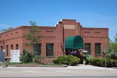 | Gillette City Hall (1936) | building | 2019 | 100004422 |
| Gillette Downtown Historic District | district | 2023 | 100008517 | |
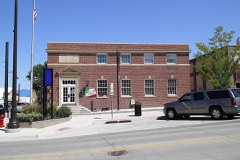 | Gillette Post Office | building | 2008 | 08001002 |
Every wildfire the federal occurrence database records inside this county: 1,595 of them, burning about 158,443 acres. 573 started naturally and 3 were recorded as arson. Each settlement page carries the fires within five miles of it.
| Reported cause | Fires |
|---|---|
| Natural | 573 |
| Missing data/not specified/undetermined | 443 |
| Railroad operations and maintenance | 194 |
| Equipment and vehicle use | 122 |
| Debris and open burning | 83 |
| Power generation/transmission/distribution | 68 |
| Fireworks | 38 |
| Misuse of fire by a minor | 31 |
| Smoking | 25 |
| Recreation and ceremony | 13 |
| Arson/incendiarism | 3 |
| Firearms and explosives use | 2 |
The five largest, by the area the report gives. None of them was recorded as arson.
| Date | Cause | Size | Reported by | Name on the report |
|---|---|---|---|---|
| 31 October 1999 | Power generation/transmission/distribution | 20,000 acres | Casper Field Office | CLARKELEN |
| 17 July 2016 | Missing data/not specified/undetermined | 20,000 acres | Wyoming State Forestry | not named |
| 28 June 2002 | Natural | 6,949 acres | Buffalo Field Office | POWNELL |
| 7 August 2006 | Natural | 6,612 acres | Buffalo Field Office | HORSE CREEK 2 |
| 29 June 2002 | Natural | 5,321 acres | Buffalo Field Office | DALEY |
| 24 August 2006 | Natural | 4,704 acres | Buffalo Field Office | LITTLE POWDER |
| 12 August 2007 | Natural | 4,321 acres | Buffalo Field Office | DUCK CREEK |
| 22 August 2011 | Natural | 4,212 acres | Buffalo Field Office | ROURKE |
Every settlement page carries the fires within five miles of it - see the settlement index below.
The NOAA Storm Events Database holds 1,114 reports for this county, causing 4 deaths, 45 injuries and about $84,219,180 in recorded property damage. Each settlement page carries the reports that name it.
| Kind of event | Reports |
|---|---|
| Hail | 580 |
| Thunderstorm Wind | 396 |
| Tornado | 92 |
| Flash Flood | 14 |
| Funnel Cloud | 12 |
| Flood | 11 |
| Lightning | 4 |
| Heavy Rain | 3 |
| Wildfire | 2 |
The most serious of them, by death, then injury, then recorded damage. The accounts are quoted exactly as the forecast office filed them.
| When | Event | Place named | Harm | What the report says |
|---|---|---|---|---|
| August 2005 | Tornado (F2) | Wright | 2 killed, 13 hurt, $5,000,000 | A tornado touched down 1 mile north of Wright and traveled southeast into the town. It crossed Wyoming Highway 387, slammed into a mobile home park, and dissipated a half mile from the highway before reaching the elementary school and Wright Blvd on the southeast edge of the park. It damaged 120 of the approximately 250 homes in the park; 91 were completely destroyed. Roofs, porches, siding, and trees sustained light damage from the strong wind gusts. Two people were killed and 13 injured; all were in mobile homes. |
| July 2008 | Flash Flood | Recluse | 1 killed, 3 hurt | Water rushing down a canyon washed out a culvert and a small section of Trail Creek Road east of Highway 59. A pickup truck drove into the washed out section of road, resulting in one fatality and three injuries. |
| August 2013 | Heavy Rain | Gillette | 1 killed | A man checking if a culvert was clogged after heavy rain was swept into the culvert and drowned. |
| June 2023 | Tornado (EF2) | Wright | 8 hurt | A tornado developed near the Campbell-Converse County line southeast of Wright, where it snapped wooden power poles and tipped over several empty train cars. It struck the operations area of the North Antelope Rochelle Coal Mine, ripping metal roofs and wall panels from shop buildings; moving and flipping cars, buses, and shipping containers; and overturning empty railroad cars. Damage severity indicated wind gusts were as high as 120 to 130 mph. No track was visible across the vegetation. Seven people sustained mostly minor injuries at the mine. The tornado continued into southwestern Weston County. |
| July 1966 | Tornado (F2) | not stated | 6 hurt, $25,000 | no account filed |
| August 2001 | Thunderstorm Wind | Gillette | 4 hurt, $50,000 | Thunderstorm wind gusts blew over a fifth-wheel trailer. Four injuries (direct) occurred to the four occupants of the trailer. The injured people were treated and released from a local hospital. The trailer was not tied, or had it's wheels blocked, and awnings were extended. The trailer landed on an auto parked beside it. |
| June 2006 | Thunderstorm Wind | Gillette | 3 hurt, $2,000 | The roof of a masonry ballpark dugout blew off, injuring 3 people. The injuries to two adults and a 2 year old child were minor. |
| May 1988 | Tornado (F2) | not stated | 2 hurt, $2,500,000 | no account filed |
| June 2018 | Tornado (EF3) | (Gcc)Gillette Arpt | 2 hurt | This tornado touched down about ten miles west-northwest of downtown Gillette. It was on the ground for about 11 minutes over the Oriva Hills subdivision. The tornado destroyed and damaged numerous homes and outbuildings, rolled vehicles, and snapped electrical transmission poles and trees. Top wind speeds were estimated at 136 mph, so the tornado was rated as an EF-3. |
| July 1995 | Hail | Gillette | 2 hurt | One inch diameter hail fell in Recluse and in Gillette. The hail damaged trees and gardens in Gillette. One outdoor booth at a rodeo in Gillette was demolished and some trailers were damaged. At the same rodeo, 2 people sustained minor injuries due to the hail. The hail was in drifts 6 to 8 inches deep in Gillette. |
| June 2010 | Lightning | Wright | 1 hurt | no account filed |
| June 1975 | Tornado (F2) | not stated | 1 hurt | no account filed |
| May 2010 | Hail | Gillette | $46,000,000 | no account filed |
| June 2003 | Hail | Gillette | $17,000,000 | no account filed |
| August 2013 | Hail | Wright | $10,000,000 | Large amounts of ping pong to golf ball size hail fell around Wright. Portions of town had hail drifts three to five feet high. The wind-driven hail caused extensive damage to homes and vehicles. |
| August 1993 | Tornado (F1) | Gillette | $500,000 | A rancher east of Gillette reported a tornado touched down briefly and destroyed a building and ripping a roof off a barn. No injuries with this storm. |
| May 2001 | Flash Flood | Gillette | $400,000 | no account filed |
| May 1978 | Tornado | not stated | $250,000 | no account filed |
| May 1978 | Tornado | not stated | $250,000 | no account filed |
| August 1976 | Tornado (F1) | not stated | $250,000 | no account filed |
| August 2009 | Hail | Gillette | $200,000 | Hail damaged houses and automobiles in the Oriva Hills subdivision northwest of Gillette. |
| September 1995 | Thunderstorm Wind | Rozet | $200,000 | Damage was extensive in Moorcroft due to strong thunderstorm winds. Two-thirds of the roof at the high school was severely damaged. Also, many trees and mainly small buildings were damaged. A grainery filled with grain was lifted off the grain near Rozet and landed one-half mile away. In addition, three telephone poles were knock over by the winds near Moorcroft. |
| August 2013 | Flash Flood | Wright | $150,000 | Heavy rain flooded road, yards, and basements in Wright after drainage systems became clogged with hail. A dam on Panther Pond was overtopped; the Wright Golf Course was flooded; and some roads, including Wright Boulevard and rural roads on the south side of Wright; were covered with as much as two feet of water. |
| July 2010 | Thunderstorm Wind | Rozet | $150,000 | Wind-driven hail damaged siding, windows, and roofs of several buildings along Adon and Grey Roads. A medium-sized horse trailer was flipped over. |
| July 2012 | Thunderstorm Wind | Rozet | $100,000 | The Campbell County emergency manager reported a shop building roof was torn off and blown 200 feet. Many houses in the area received damage to siding. |
| July 2010 | Hail | Rozet | $100,000 | Hail size ranged from golf ball to softball. |
| July 2009 | Thunderstorm Wind | Wright | $100,000 | The combination of hail and wind damaged automobiles. |
| June 2011 | Hail | Gillette | $100,000 | no account filed |
| July 2003 | Thunderstorm Wind | Gillette | $100,000 | no account filed |
| July 2002 | Thunderstorm Wind | Gillette | $70,000 | no account filed |
| May 2007 | Flood | Gillette | $58,000 | no account filed |
| June 2018 | Tornado (EF1) | Gillette | $50,000 | A short-lived landspout tornado developed three miles north-northeast of downtown Gillette in the Warrior Hills subdivision. It damaged a large shed, flipped a camper onto a vehicle, destroyed another camper, and damaged several wooded fences. Winds were estimated at 80 to 90 mph, giving the tornado a rating as a weak EF-1. |
| June 1994 | Thunderstorm Wind | not stated | $50,000 | A severe microburst struck the city of Gillette early on the afternoon of the 8th. The official peak gust measured north of the city at the airport was 53 knots, but stronger winds were reported in the city itself. Numerous trees and large limbs were blown down throughout the city. An 80 x 100 feet section of roof was blown off a storage building by the wind. |
| August 2013 | Hail | Gillette | $50,000 | no account filed |
| August 2002 | Thunderstorm Wind | Gillette | $40,000 | no account filed |
| June 2010 | Thunderstorm Wind | Rozet | $30,000 | Several power poles were blown down along Bishop Road, a 12 inch diameter tree was snapped, and a deck was torn from a house and thrown 100 yards. |
| May 2013 | Flash Flood | Echeta | $25,000 | Water ponded along the Burlington-Santa Fe railroad tracks ten miles northwest of Gillette. The heavy rain left ruts in some gravel roads. |
| July 2012 | Thunderstorm Wind | Rozet | $25,000 | A portion of a house roof was peeled off and a shop building was severely damaged. |
| June 2008 | Hail | Weston | $25,000 | Large hail damaged two houses. |
| July 1997 | Thunderstorm Wind | Gillette | $25,000 | no account filed |
| July 1983 | Tornado (F1) | not stated | $25,000 | no account filed |
| May 1959 | Tornado (F2) | not stated | $25,000 | no account filed |
| June 1956 | Tornado (F1) | not stated | $25,000 | no account filed |
| July 2012 | Thunderstorm Wind | Rozet | $20,000 | Wind gusts were estimated at 60 mph. |
| June 2010 | Thunderstorm Wind | Rozet | $20,000 | A forty by sixty foot shop building was destroyed by strong wind gusts with large pieces of the roof and walls blown about 100 yards from the foundation. |
| June 2000 | Thunderstorm Wind | Rozet | $20,000 | A trailer home was flipped over and destroyed. A camper trailer was destroyed and a 100 gallon fuel tank that was partially full was blown over. |
| June 2007 | Hail | Weston | $15,000 | Hail broke house windows. |
| June 2014 | Tornado (EF0) | Savageton | $10,000 | A tornado destroyed a pole barn, damaged another small shed, and blew down power poles. |
| May 2014 | Flash Flood | (Gcc)Gillette Arpt | $10,000 | WY Highway 59 north of Gillette was flooded in two locations. The Gillette-Campbell County Airport was closed when Airport Road became flooded. A few cars were damaged while trying to drive through floodwaters over Foothills Boulevard. |
| June 2010 | Thunderstorm Wind | Weston | $10,000 | A spotter's weather station measured a wind gust of 87 mph. |
| June 2008 | Tornado (EF0) | Gillette | $10,000 | A small tornado touched down briefly in the Highland Subdivision. It blew shingles off a roof, tore siding from a house, and blew down a portion of a fence. |
| September 2013 | Thunderstorm Wind | (Gcc)Gillette Arpt | $10,000 | no account filed |
| August 2013 | Hail | Rozet | $10,000 | no account filed |
| June 2010 | Hail | Weston | $10,000 | no account filed |
| July 2010 | Hail | Rozet | $10,000 | no account filed |
| June 2006 | Thunderstorm Wind | Wright | $10,000 | no account filed |
| August 2011 | Hail | Rockypoint | $7,000 | Hail accumulated three inches deep and poked holes in the siding of a house. |
| July 2001 | Thunderstorm Wind | Rozet | $6,000 | no account filed |
| August 2013 | Thunderstorm Wind | Recluse | $5,000 | The combination of wind and hail caused minor damage. |
| June 2013 | Thunderstorm Wind | Gillette | $5,000 | Strong winds tore the roof off a garage. |
The Survey's mineral resources record lists 425 workings inside this county. 13 still produce and 412 are closed or unrecorded. Each settlement page carries the workings within five miles of it.
| Commodity | Workings |
|---|---|
| Uranium | 409 |
| Sand and Gravel, Construction | 7 |
| Stone, Crushed/Broken | 4 |
| Pumice | 3 |
| Uranium, Selenium | 1 |
| Tungsten | 1 |
The least common of them first, because a county's hundredth gravel pit says nothing its first ten did not.
| Where | Site | Commodity | Status | Recorded |
|---|---|---|---|---|
| Campbell Group | Uranium, Selenium | Past Producer | Coffinite, Tyuyamunite, Uraninite, Uranophane | |
| Le Roy Moore | Tungsten | Occurrence | ||
| Hines Pit | Pumice | Producer | ||
| Potter Pit | Pumice | Producer | ||
| Shepherd Pit | Pumice | Producer | ||
| Clyde Potter | Stone, Crushed/Broken | Past Producer | ||
| Ostlund Pit | Stone, Crushed/Broken | Producer | ||
| Unknown | Stone, Crushed/Broken | Prospect | ||
| Unknown | Stone, Crushed/Broken | Past Producer | ||
| Burkhardt Pit | Sand and Gravel, Construction | Producer | ||
| Durham Neat Co. | Sand and Gravel, Construction | Producer | ||
| Geis Scoria Pit #1 | Sand and Gravel, Construction | Producer | ||
| Harris Pit | Sand and Gravel, Construction | Producer | ||
| Hornet Pit | Sand and Gravel, Construction | Past Producer | ||
| Meadowlark No. 6 Pit | Sand and Gravel, Construction | Past Producer | ||
| Wright Pit | Sand and Gravel, Construction | Producer | ||
| A Group | Uranium | Occurrence | Stratabound | |
| A-261 | Uranium | Past Producer | ||
| A-93 Mine | Uranium | Past Producer | ||
| Aec Anomaly 342 | Uranium | Prospect | ||
| Aec Ra No.3-07 | Uranium | Occurrence | ||
| Albert Orr Ranch | Uranium | Occurrence | Stratabound | |
| Alma Claims | Uranium | Occurrence | Stratabound | |
| Alma No.8 | Uranium | Prospect | ||
| Anom No. 313 | Uranium | Occurrence | ||
| Anomalies 10 + 11 | Uranium | Occurrence | ||
| Anomalies 19 & 20 | Uranium | Occurrence | ||
| Anomalies 36 & 37 | Uranium | Occurrence | ||
| Anomalies B-04,3-05 3-06 Usgs | Uranium | Occurrence | ||
| Anomalies No.13 & 14 | Uranium | Occurrence | ||
| Anomaly #119 | Uranium | Past Producer | ||
| Anomaly 119 | Uranium | Occurrence | Stratabound | |
| Anomaly 119 | Uranium | Occurrence | ||
| Anomaly 119 (Blowout) | Uranium | Past Producer | Tyuyamunite, Uraninite, Uranophane | |
| Anomaly 14 | Uranium | Occurrence | Stratabound | |
| Anomaly 24 | Uranium | Occurrence | Stratabound | |
| Anomaly No 133 Usgs | Uranium | Occurrence | ||
| Anomaly No 135 Usgs | Uranium | Occurrence | ||
| Anomaly No 160 Usgs | Uranium | Occurrence | ||
| Anomaly No 22 Usgs | Uranium | Occurrence | ||
| Anomaly No 332 | Uranium | Occurrence | ||
| Anomaly No 35 | Uranium | Occurrence | ||
| Anomaly No 38 | Uranium | Occurrence | ||
| Anomaly No 47 | Uranium | Occurrence | ||
| Anomaly No.1 | Uranium | Occurrence | ||
| Anomaly No.132 | Uranium | Occurrence | ||
| Anomaly No.2 | Uranium | Occurrence | ||
| Anomaly No.32 | Uranium | Occurrence | ||
| Anomaly No.5 | Uranium | Occurrence | ||
| Anomaly No.94 | Uranium | Occurrence | ||
| Ariz, Utah, Colo. | Uranium | Occurrence | Stratabound | |
| Axe | Uranium | Past Producer | ||
| Axe Claims | Uranium | Occurrence | Liebigite | |
| B Group | Uranium | Occurrence | Stratabound | |
| B. Rosenberger Property | Uranium | Past Producer | ||
| Bar None No.40 Claim | Uranium | Prospect | ||
| Bashawn Group | Uranium | Past Producer | ||
| Ben #1 | Uranium | Occurrence | Stratabound | |
| Ben #1 Prospect | Uranium | Occurrence | Tyuyamunite | |
| Betty No.12 | Uranium | Past Producer | ||
| Big Tar Group | Uranium | Occurrence | ||
| Black Star | Uranium | Past Producer | ||
| Blue Star | Uranium | Occurrence | ||
| Blue Star #1 | Uranium | Past Producer | ||
| Brown Deposit | Uranium | Unknown | ||
| Camp No.1 Claim | Uranium | Prospect | ||
| Campbin & West | Uranium | Past Producer | ||
| Camplin No. 1 & 3 | Uranium | Past Producer | ||
| Charles Mankin Ranch,Aec Anomaly#34 | Uranium | Occurrence | ||
| Christensen Bros.Ranch | Uranium | Occurrence | ||
| Christensen Lease | Uranium | Unknown | ||
| Christenson Ranch Anomaly No. 65 | Uranium | Occurrence | ||
| Christiansen Lease | Uranium | Past Producer | ||
| Clover Sterling | Uranium | Past Producer | ||
| Coldspot | Uranium | Past Producer | ||
| Collins Draw | Uranium | Producer | ||
| Colo. Christensen | Uranium | Past Producer | ||
| Colorado #1 Claim | Uranium | Occurrence | Stratabound | |
| Colorado #1 Claim | Uranium | Occurrence | Tyuyamunite | |
| Cora Group | Uranium | Past Producer | ||
| Dale Creek | Uranium | Unknown | ||
| Discovery Roll | Uranium | Unknown | ||
| Doe,Sue | Uranium | Past Producer | ||
| Dome Butte | Uranium | Prospect | ||
| Doughstick and North Jane | Uranium | Prospect | ||
| Earl Brown Property | Uranium | Occurrence | ||
| Earl Brown,Surface;Withdrawn Area | Uranium | Occurrence | ||
| Earl Brown-Kerr Mcgee | Uranium | Occurrence | ||
| East North Butte area (part of West North Butte Satellite Properties) | Uranium | Prospect | ||
| Fillbrink Fee Land | Uranium | Past Producer | ||
| Hank Claims | Uranium | Occurrence | Stratabound | |
| Hank Unit | Uranium | Prospect | Roll-front uranium | |
| Hawley Nos 1-32 Claims | Uranium | Occurrence | ||
| Howell | Uranium | Occurrence | ||
| Innes Lease | Uranium | Past Producer | ||
| Ira Group | Uranium | Past Producer | ||
| Jack R Bond Property | Uranium | Past Producer | ||
| Jake | Uranium | Past Producer | ||
| Jake Claim | Uranium | Occurrence | Stratabound | |
| Jannie Group | Uranium | Past Producer | ||
| Jeanette Claim | Uranium | Past Producer | Stratabound | |
| Joyce #9 | Uranium | Past Producer | ||
| K.I.S.U.Mining Co.Ore Lease | Uranium | Past Producer | ||
| Kelley Mine | Uranium | Occurrence | Stratabound | |
| Kerr Mcgee | Uranium | Unknown | ||
| Kerr Mcgee Property | Uranium | Past Producer | ||
| Kerr-Mcgee | Uranium | Unknown | ||
| Kerr-Mcgee Claim | Uranium | Occurrence | ||
| Kerr-Mcgee Jim Claim | Uranium | Occurrence | ||
| Kerr-Mcgee Post Grp.Claims-No.1 | Uranium | Occurrence | ||
| Kerr-Mcgee Post Grp.Claims-No.2 | Uranium | Occurrence | ||
| Kerr-Mcgee School Lease | Uranium | Prospect | ||
| Kerr-Mcgee, Ed Claims | Uranium | Occurrence | ||
| Key Claims | Uranium | Past Producer | Stratabound | |
| Kisu Mine | Uranium | Occurrence | Stratabound | |
| Km # 1 | Uranium | Past Producer | ||
| Laur | Uranium | Past Producer | ||
| Little Betty | Uranium | Prospect | ||
| Little Phoebe (Gap Group) | Uranium | Past Producer | ||
| Little Star | Uranium | Past Producer | ||
| Loc 127 | Uranium | Occurrence | Stratabound | |
| Loc 178 | Uranium | Occurrence | Stratabound | |
| Loc 6 | Uranium | Occurrence | Stratabound | |
| Loc. #3. | Uranium | Occurrence | Stratabound | |
| Loc. #4 | Uranium | Occurrence | Stratabound | |
| Loc. #5. | Uranium | Occurrence | Stratabound | |
| Loc. #52. | Uranium | Occurrence | Stratabound | |
| Loc. #62 | Uranium | Occurrence | Stratabound | |
| Loc. #7. | Uranium | Occurrence | Stratabound | |
| Loc. 1 | Uranium | Occurrence | Stratabound | |
| Loc. 10 | Uranium | Occurrence | Stratabound | |
| Loc. 106 | Uranium | Occurrence | Stratabound | |
| Loc. 11 | Uranium | Occurrence | Stratabound | |
| Loc. 119, 150 | Uranium | Occurrence | Stratabound | |
| Loc. 12 | Uranium | Occurrence | Stratabound | |
| Loc. 14 | Uranium | Occurrence | Stratabound | |
| Loc. 140 | Uranium | Occurrence | Stratabound | |
| Loc. 147 | Uranium | Occurrence | Stratabound | |
| Loc. 16, 17, 18, 19, 31 | Uranium | Occurrence | Stratabound | |
| Loc. 174 | Uranium | Occurrence | Stratabound | |
| Loc. 2 | Uranium | Occurrence | Stratabound | |
| Loc. 21 | Uranium | Occurrence | Stratabound | |
| Loc. 22 | Uranium | Occurrence | Stratabound | |
| Loc. 25 | Uranium | Occurrence | Stratabound | |
| Loc. 33 | Uranium | Occurrence | Stratabound | |
| Loc. 37 | Uranium | Occurrence | Stratabound | |
| Loc. 55 | Uranium | Occurrence | Stratabound | |
| Loc. 56 | Uranium | Occurrence | Stratabound | |
| Loc. 58 | Uranium | Occurrence | Stratabound | |
| Loc. 67 | Uranium | Occurrence | Stratabound | |
| Loc. 70 | Uranium | Occurrence | Stratabound | |
| Loc. 74, 75 | Uranium | Occurrence | Stratabound | |
| Loc. 81 | Uranium | Occurrence | Stratabound | |
| Loc. 85 | Uranium | Occurrence | Stratabound | |
| Loc. 9 | Uranium | Occurrence | Stratabound | |
| Loc. No. 151 | Uranium | Occurrence | Stratabound | |
| Loc. No. 158 | Uranium | Occurrence | Stratabound | |
| Loc. No. 26, 27, 28, 29 | Uranium | Occurrence | Stratabound | |
| Loc. No. 30 | Uranium | Occurrence | Stratabound | |
| Loc. No. 43 | Uranium | Occurrence | Stratabound | |
| Loc. No. 93 | Uranium | Occurrence | Stratabound | |
| Locality | Uranium | Occurrence | ||
| Locality #70 | Uranium | Occurrence | ||
| Locality No. 99. | Uranium | Occurrence | Stratabound | |
| Lucky 8 | Uranium | Past Producer | ||
| Mabel Ward,Surface | Uranium | Occurrence | ||
| Mary No. 1 & 3 | Uranium | Past Producer | ||
| Mc Group | Uranium | Past Producer | ||
| Miracle Mile #1 | Uranium | Past Producer | ||
| Moore Ranch ISL | Uranium | Prospect | ||
| Mystery | Uranium | Unknown | ||
| Mystery | Uranium | Prospect | ||
| Nero Group | Uranium | Past Producer | ||
| Nichols Ranch ISL | Uranium | Prospect | roll-front uranium | |
| North America Mine | Uranium | Producer | Stratabound | |
| North Rolling Pin | Uranium | Prospect | ||
| Orr Group | Uranium | Prospect | ||
| Osage | Uranium | Past Producer | ||
| Pat No.1 | Uranium | Occurrence | ||
| Paula | Uranium | Past Producer | ||
| Paula #1 | Uranium | Occurrence | Stratabound | |
| Pete | Uranium | Occurrence | Stratabound | |
| Pete Group | Uranium | Past Producer | ||
| Pit On Innes Lease | Uranium | Past Producer | ||
| Powder River Minerals Pit | Uranium | Past Producer | ||
| Praest | Uranium | Past Producer | ||
| Pumpkin Buttes District | Uranium | Producer | ||
| Queen No.2 | Uranium | Past Producer | ||
| Quigley & Gall Claims | Uranium | Occurrence | ||
| Quigley & Gall Colorado No.1 | Uranium | Prospect | ||
| Quigley and Gall | Uranium | Occurrence | Stratabound | |
| Ray | Uranium | Occurrence | Stratabound | |
| Reno Fee Land | Uranium | Prospect | ||
| Reno Lease | Uranium | Prospect | ||
| Reno Ranch | Uranium | Past Producer | ||
| Rho Group | Uranium | Past Producer | ||
| Ruthie B. | Uranium | Past Producer | ||
| Sable Group | Uranium | Past Producer | ||
| San Juan | Uranium | Past Producer | ||
| San Juan Uranium Explor Prop #2 | Uranium | Past Producer | ||
| School Sect State of Wyo Anomaly No | Uranium | Occurrence | ||
| School Section Mine | Uranium | Occurrence | Stratabound | |
| School Section-Anomaly # 48 | Uranium | Occurrence | ||
| Scott | Uranium | Past Producer | ||
| Simmons No. 1 | Uranium | Past Producer | ||
| Simmons No. 2 | Uranium | Past Producer | ||
| South School Section | Uranium | Occurrence | Carnotite, Uranophane | |
| South School Section | Uranium | Past Producer | ||
| State Lease #0-13238 | Uranium | Past Producer | ||
| State Lease #13231 | Uranium | Past Producer | ||
| Sue #3 | Uranium | Past Producer | ||
| Sundance Mine | Uranium | Producer | Stratabound | |
| Syl Del | Uranium | Past Producer | ||
| Taylor Ranch Co Anomaly 1 | Uranium | Occurrence | ||
| Teachair | Uranium | Past Producer | ||
| Trix Group | Uranium | Past Producer | ||
| Turnercrest | Uranium | Past Producer | ||
| U S G S Anomaly No 134 | Uranium | Occurrence | ||
| U S G S Anomaly No 136 | Uranium | Occurrence | ||
| U S G S Anomaly No 139 | Uranium | Occurrence | ||
| Unidentified Occurrence | Uranium | Occurrence | ||
| Unidentified Occurrence | Uranium | Occurrence | ||
| Unidentified Occurrence | Uranium | Occurrence | Tyuyamunite | |
| Unknown | Uranium | Occurrence | Stratabound | |
| Unknown | Uranium | Occurrence | Stratabound | |
| Unknown | Uranium | Occurrence | Stratabound | |
| Unknown | Uranium | Occurrence | Stratabound | |
| Unknown | Uranium | Occurrence | Stratabound | |
| Unknown | Uranium | Occurrence | Stratabound | |
| Unknown | Uranium | Occurrence | Stratabound | |
| Unknown | Uranium | Occurrence | Stratabound | |
| Unknown | Uranium | Occurrence | Stratabound | |
| Unknown | Uranium | Occurrence | Stratabound | |
| Unknown | Uranium | Occurrence | Stratabound | |
| Unknown | Uranium | Occurrence | ||
| Unknown | Uranium | Occurrence | ||
| Unknown | Uranium | Occurrence | ||
| Unknown | Uranium | Past Producer | ||
| Unknown | Uranium | Occurrence | ||
| Unknown | Uranium | Occurrence | ||
| Unknown | Uranium | Past Producer | ||
| Unknown | Uranium | Occurrence | ||
| Unknown | Uranium | Occurrence | ||
| Unknown | Uranium | Prospect | ||
| Unknown | Uranium | Occurrence | ||
| Unknown | Uranium | Occurrence | ||
| Unknown | Uranium | Prospect | ||
| Unknown | Uranium | Occurrence | ||
| Unknown | Uranium | Past Producer | ||
| Unknown | Uranium | Occurrence | ||
| Unknown | Uranium | Occurrence | ||
| Unknown | Uranium | Occurrence | ||
| Unknown | Uranium | Occurrence | ||
| Unknown | Uranium | Occurrence | ||
| Unknown | Uranium | Past Producer | ||
| Unknown | Uranium | Occurrence | ||
| Unknown | Uranium | Past Producer | ||
| Unknown | Uranium | Occurrence | ||
| Unknown | Uranium | Past Producer | ||
| Unknown | Uranium | Occurrence | ||
| Unknown | Uranium | Occurrence | ||
| Unknown | Uranium | Occurrence | ||
| Unknown | Uranium | Occurrence | ||
| Unknown | Uranium | Occurrence | ||
| Unknown | Uranium | Occurrence | ||
| Unknown | Uranium | Occurrence | ||
| Unknown | Uranium | Unknown | ||
| Unknown | Uranium | Occurrence | ||
| Unknown | Uranium | Past Producer | ||
| Unknown | Uranium | Occurrence | ||
| Unknown | Uranium | Occurrence | ||
| Unknown | Uranium | Occurrence | ||
| Unknown | Uranium | Occurrence | ||
| Unknown | Uranium | Occurrence | ||
| Unknown | Uranium | Occurrence | ||
| Unknown | Uranium | Occurrence | ||
| Unknown | Uranium | Occurrence | ||
| Unknown | Uranium | Occurrence | ||
| Unknown | Uranium | Occurrence | ||
| Unknown | Uranium | Occurrence | ||
| Unknown | Uranium | Occurrence | ||
| Unknown | Uranium | Occurrence | ||
| Unknown | Uranium | Past Producer | ||
| Unknown | Uranium | Occurrence | ||
| Unknown | Uranium | Past Producer | ||
| Unknown | Uranium | Past Producer | ||
| Unknown | Uranium | Occurrence | ||
| Unknown | Uranium | Occurrence | ||
| Unknown | Uranium | Occurrence | ||
| Unknown | Uranium | Past Producer | ||
| Unknown | Uranium | Occurrence | ||
| Unknown | Uranium | Occurrence | ||
| Unknown | Uranium | Occurrence | ||
| Unknown | Uranium | Occurrence | ||
| Unknown | Uranium | Prospect | ||
| Unknown | Uranium | Prospect | ||
| Unknown | Uranium | Prospect | ||
| Unknown | Uranium | Past Producer | ||
| Unknown | Uranium | Occurrence | ||
| Unknown | Uranium | Occurrence | ||
| Unknown | Uranium | Occurrence | ||
| Unknown | Uranium | Occurrence | ||
| Unknown | Uranium | Occurrence | ||
| Unknown | Uranium | Occurrence | ||
| Unknown | Uranium | Past Producer | ||
| Unknown | Uranium | Occurrence | ||
| Unknown | Uranium | Occurrence | ||
| Unknown | Uranium | Occurrence | ||
| Unknown | Uranium | Occurrence | ||
| Unknown | Uranium | Past Producer | ||
| Unknown | Uranium | Occurrence | ||
| Unknown | Uranium | Occurrence | ||
| Unknown | Uranium | Occurrence | ||
| Unknown | Uranium | Occurrence | ||
| Unknown | Uranium | Prospect | ||
| Unknown | Uranium | Past Producer | ||
| Unknown | Uranium | Past Producer | ||
| Unknown | Uranium | Occurrence | ||
| Unknown | Uranium | Prospect | ||
| Unknown | Uranium | Occurrence | ||
| Unknown | Uranium | Occurrence | ||
| Unknown | Uranium | Occurrence | ||
| Unknown | Uranium | Past Producer | ||
| Unknown | Uranium | Occurrence | ||
| Unknown | Uranium | Occurrence | ||
| Unknown | Uranium | Occurrence | ||
| Unknown | Uranium | Occurrence | ||
| Unknown | Uranium | Occurrence | ||
| Unknown | Uranium | Occurrence | ||
| Unknown | Uranium | Occurrence | ||
| Unknown | Uranium | Occurrence | ||
| Unknown | Uranium | Occurrence | ||
| Unknown | Uranium | Occurrence | ||
| Unknown | Uranium | Occurrence | ||
| Unknown | Uranium | Occurrence | ||
| Unknown | Uranium | Occurrence | ||
| Unknown | Uranium | Occurrence | ||
| Unknown | Uranium | Occurrence | ||
| Unknown | Uranium | Occurrence | ||
| Unknown | Uranium | Occurrence | ||
| Unknown | Uranium | Past Producer | ||
| Unknown | Uranium | Occurrence | ||
| Unknown | Uranium | Past Producer | ||
| Unknown | Uranium | Occurrence | ||
| Unknown | Uranium | Past Producer | ||
| Unknown | Uranium | Past Producer | ||
| Unknown | Uranium | Prospect | ||
| Unknown | Uranium | Occurrence | ||
| Unknown | Uranium | Occurrence | ||
| Unknown | Uranium | Occurrence | ||
| Unknown | Uranium | Past Producer | ||
| Unknown | Uranium | Prospect | ||
| Unknown | Uranium | Occurrence | ||
| Unknown | Uranium | Unknown | ||
| Unknown | Uranium | Occurrence | ||
| Unknown | Uranium | Occurrence | ||
| Unknown | Uranium | Prospect | ||
| Unknown | Uranium | Occurrence | ||
| Unknown | Uranium | Occurrence | ||
| Unknown | Uranium | Occurrence | ||
| Unknown | Uranium | Occurrence | ||
| Unknown | Uranium | Occurrence | ||
| Unknown | Uranium | Occurrence | ||
| Unknown | Uranium | Past Producer | ||
| Unknown | Uranium | Occurrence | ||
| Unknown | Uranium | Occurrence | ||
| Unknown | Uranium | Past Producer | ||
| Unknown | Uranium | Occurrence | ||
| Unknown | Uranium | Occurrence | ||
| Unknown | Uranium | Occurrence | ||
| Unknown | Uranium | Occurrence | ||
| Unknown | Uranium | Occurrence | ||
| Unknown | Uranium | Occurrence | ||
| Unknown | Uranium | Occurrence | ||
| Unknown | Uranium | Occurrence | ||
| Unknown | Uranium | Occurrence | ||
| Unknown | Uranium | Occurrence | ||
| Unknown | Uranium | Past Producer | ||
| Unknown | Uranium | Occurrence | ||
| Unknown | Uranium | Occurrence | ||
| Unknown | Uranium | Occurrence | ||
| Unknown | Uranium | Occurrence | ||
| Unknown | Uranium | Occurrence | ||
| Unknown | Uranium | Occurrence | ||
| Unknown | Uranium | Occurrence | ||
| Unknown | Uranium | Occurrence | ||
| Unknown | Uranium | Prospect | ||
| Unknown | Uranium | Occurrence | ||
| Unknown | Uranium | Occurrence | ||
| Unknown | Uranium | Past Producer | ||
| Unknown | Uranium | Occurrence | ||
| Unknown | Uranium | Occurrence | ||
| Unknown | Uranium | Occurrence | ||
| Unknown | Uranium | Occurrence | ||
| Unknown | Uranium | Occurrence | ||
| Unknown | Uranium | Occurrence | ||
| Unknown | Uranium | Occurrence | ||
| Unknown | Uranium | Occurrence | ||
| Unknown | Uranium | Occurrence | ||
| Unknown | Uranium | Past Producer | ||
| Unknown | Uranium | Past Producer | ||
| Unknown | Uranium | Occurrence | ||
| Unknown | Uranium | Occurrence | ||
| Unknown | Uranium | Occurrence | ||
| Utah 1, 2, 3, 4 | Uranium | Occurrence | Stratabound | |
| Utah Mine | Uranium | Past Producer | ||
| Van Buggenum No. 1 | Uranium | Past Producer | ||
| Van Buggenum No. 2 | Uranium | Past Producer | ||
| Virgil Rossbach Fee Land | Uranium | Occurrence | ||
| Walmare No.26 | Uranium | Occurrence | ||
| West North Butte area (part of West North Butte Satellite Properties) | Uranium | Prospect | ||
| White Mule | Uranium | Unknown | ||
| Willis Oser AEC Anomaly #24 | Uranium | Prospect | ||
| Willow Creek (part of West North Butte Satellite Properties) | Uranium | Prospect | ||
| Wm. Moore Fee | Uranium | Occurrence | Stratabound | |
| Wyo Roc | Uranium | Past Producer |
Named settlements recorded in the Geographic Names Information System, each with the topographic sheets covering it. Villages, hamlets and abandoned places alike. Each is shown with the nearest named watercourse or landform and the survey quadrangle it falls on.
Gillette North census division · 82727 · On Mitchell Creek · Adon quadrangle
8 sheets, 1954 to 1975
Gillette South census division · 82718 · Near Antelope Butte · The Gap quadrangle
9 sheets, 1954 to 1974
Gillette North census division · 82718 · On Stonepile Creek · Gillette East quadrangle
10 sheets, 1954 to 1974
Gillette North census division · 82716 · Near Cedar Draw · Croton quadrangle
8 sheets, 1954 to 1975
Gillette North census division · 82716 · On Rough Creek · Echeta quadrangle
8 sheets, 1954 to 1974
Gillette South census division · 82718 · Pleasantdale quadrangle
8 sheets, 1954 to 1974
Gillette North census division · 82731 · Near Rocky Point · Rockypoint quadrangle
8 sheets, 1954 to 1975
Gillette South census division · 82727 · On Ward Creek · Rozet quadrangle
8 sheets, 1954 to 1974
Gillette North census division · 82831 · Near Chicken Creek Draw · Spotted Horse quadrangle
8 sheets, 1954 to 1975
Gillette South census division · 82718 · On Antelope Butte Creek · Gillette East quadrangle
10 sheets, 1954 to 1974
Gillette South census division · 82718 · On North Bates Creek · Turnercrest quadrangle
8 sheets, 1955 to 1984
Gillette North census division · 82716 · Near Bright Spring Draw · Wildcat quadrangle
8 sheets, 1954 to 1975
Gillette South census division · 82718 · Little Thunder Reservoir quadrangle
7 sheets, 1955 to 1974