 Block
From the record
7 National Register listings published here.
Sources: the National Register database, National Park Service
76 topographic sheets cover 18 settlements here, and 7 properties are on the National Register of Historic Places.
7 National Register listings published here.
Sources: the National Register database, National Park Service
Every property in this county listed on the National Register of Historic Places, with the year it was listed and the federal nomination document.
| Photograph | Property | Type | Listed | Reference |
|---|---|---|---|---|
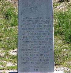 | Cheyenne-Black Hills Stage Route and Rawhide Buttes and Running Water Stage Stations | district | 1969 | 69000190 |
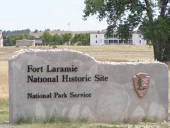 | Fort Laramie National Historic Site | district | 1966 | 66000755 |
| Fort Laramie Three-Mile Hog Ranch | building | 1975 | 75001901 | |
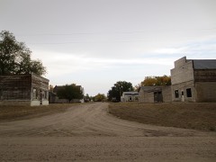 | Jay Em Historic District | district | 1984 | 84003665 |
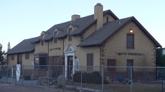 | South Torrington Union Pacific Depot | building | 1974 | 74002025 |
 | US Post Office-Torrington Main | building | 1987 | 87000783 |
Every wildfire the federal occurrence database records inside this county: 192 of them, burning about 47,488 acres. 44 started naturally and 1 was recorded as arson. Each settlement page carries the fires within five miles of it.
| Reported cause | Fires |
|---|---|
| Missing data/not specified/undetermined | 82 |
| Natural | 44 |
| Debris and open burning | 24 |
| Fireworks | 13 |
| Equipment and vehicle use | 10 |
| Recreation and ceremony | 6 |
| Misuse of fire by a minor | 5 |
| Smoking | 4 |
| Power generation/transmission/distribution | 2 |
| Railroad operations and maintenance | 1 |
| Arson/incendiarism | 1 |
The five largest, by the area the report gives. None of them was recorded as arson.
| Date | Cause | Size | Reported by | Name on the report |
|---|---|---|---|---|
| 11 July 2016 | Natural | 21,080 acres | Casper Field Office | SIMMONS FIRE |
| 5 September 2000 | Natural | 9,798 acres | Casper Field Office | CO LINE |
| 10 August 2012 | Natural | 5,000 acres | Wyoming State Forestry | GOSHEN RANGE |
| 23 July 2005 | Natural | 3,500 acres | Fort Laramie National Historic Site | PINE RIDGE |
| 22 February 2017 | Missing data/not specified/undetermined | 1,182 acres | Casper Field Office | SAND HILLS |
| 28 August 2018 | Natural | 950 acres | Goshen County | GRASS FIRE |
| 22 February 2020 | Equipment and vehicle use | 750 acres | Goshen County | 3700 HIGHWAY 26-85 |
| 7 March 2020 | Debris and open burning | 700 acres | Goshen County | 4300 BLK ROAD 82 |
Every settlement page carries the fires within five miles of it - see the settlement index below.
The NOAA Storm Events Database holds 680 reports for this county, causing no deaths, 5 injuries and about $8,730,900 in recorded property damage. Each settlement page carries the reports that name it.
| Kind of event | Reports |
|---|---|
| Hail | 447 |
| Thunderstorm Wind | 97 |
| Tornado | 90 |
| Flash Flood | 34 |
| Funnel Cloud | 6 |
| Heavy Rain | 5 |
| Lightning | 1 |
The most serious of them, by death, then injury, then recorded damage. The accounts are quoted exactly as the forecast office filed them.
| When | Event | Place named | Harm | What the report says |
|---|---|---|---|---|
| June 2011 | Thunderstorm Wind | Yoder | 2 hurt | Rear flank downdraft blew over a south bound semi trailer on Highway 85. |
| June 2017 | Tornado (EF2) | Lingle | 1 hurt, $597,000 | Significant tornado damage was noted at a ranch 20 miles north-northeast of Torrington, WY, just west of the Union Pacific railway line. Significant damage consistent with EF-2 intensity winds was to the main ranch residence and surrounding barns (DI 1, DOD 8). Several three-quarter ton pickup trucks were vaulted several yards by tornadic winds, with several horse trailers rolled 50 to 100 yards and severely damaged. Several horses at this location were seriously injured with 3 horses killed. One person in the residence received minor head injuries. The tornado continued northeast, moving into Sioux County, NE at 1630 MST. |
| May 1969 | Tornado | not stated | 1 hurt, $250,000 | no account filed |
| June 2023 | Tornado (EF2) | Hawk Springs | 1 hurt, $100,000 | A large cone tornado developed just east of US-85 south of Hawk Springs, before quickly becoming rain-wrapped. The tornado snapped cottonwood trees, with a tree branch impaling a stucco house. It also damaged outbuildings and snapped power poles. An injury occurred when the tornado flipped an 18-wheeler and injured the driver. The same tornado tracked to the southeast and damaged another outbuilding and a barn 3 miles southeast of Hawk Springs. The tornado was officially rated an EF-2. In addition to the tornado damage, straight-line winds from the Rear Flank Downdraft (RFD) damaged several hardwood trees. This is consistent with 100 MPH winds. |
| June 1984 | Tornado (F0) | not stated | $2,500,000 | no account filed |
| June 1979 | Tornado (F1) | not stated | $2,500,000 | no account filed |
| June 1999 | Hail | Yoder | $1,200,000 | no account filed |
| June 1999 | Hail | La Grange | $250,000 | no account filed |
| July 1978 | Tornado (F2) | not stated | $250,000 | no account filed |
| May 2000 | Hail | Lingle | $100,000 | no account filed |
| June 1999 | Hail | La Grange | $100,000 | no account filed |
| August 2006 | Flash Flood | La Grange | $80,000 | Rainfall from 3 to 4 inches fell over the La Grange, WY. area and produced street flooding with some water in basements. A county road bridge was also washed out. |
| June 1999 | Hail | Torrington | $75,000 | no account filed |
| August 2005 | Flash Flood | Yoder | $73,000 | Significant flooding reported in Yoder, WY, with many streets under several inches of water. |
| July 1996 | Tornado (F1) | Hawk Spgs | $70,000 | no account filed |
| June 2009 | Hail | Hawk Springs | $50,000 | Quarter to softball sized hail reported along the storm track with hail drifts from 12 to 18 inches at the junction of county roads 38 and 55. |
| May 2000 | Hail | Lingle | $50,000 | Hail and gusty winds occurred just south and west of Lingle, WY, damaging two grain bins and breaking some windows. |
| July 2023 | Thunderstorm Wind | Veteran | $35,000 | Goshen County Emergency Management reported a flipped center pivot near the intersection of Wyoming 154 and Road 60, 1 mile N of Veteran. This type of damage is consistent with approximately 90 MPH wind gusts. |
| July 2022 | Flash Flood | Lingle | $30,000 | Flash flooding of farmland and surrounding buildings after the Interstate Canal breached 1 mile northwest of Lingle. Wyoming Department of Transportation closed Highway 26 between mile markers 32 and 38 due to flash flooding on the roadway. A half mile stretch of Highway 26 is completely underwater. Flood waters reached the west side of Lingle. |
| July 1997 | Flash Flood | Torrington | $30,000 | Residential basements flooded and a county road washed out after about 6" of rain; Cameron Creek, Rawhide Creek and Torrington Ditch overflowed just N of Hwy 26. |
| May 1997 | Flash Flood | Yoder | $30,000 | Heavy rainfall totalling more than 3 inches fell from southwest of Yoder to around Torrington. Four feet of water was reported over state highway 156 2 miles south of Torrington at 515 pm MST. The flooding continued throug the evening along highways 156, 154 and 161 in the Torrington, Veteran and Yoder areas, where water continued to cover highway 161 at 827 pm MST. The water subsided by 930 pm MST. |
| May 1989 | Tornado (F1) | not stated | $25,000 | no account filed |
| June 1979 | Tornado (F1) | not stated | $25,000 | no account filed |
| July 1974 | Tornado (F1) | not stated | $25,000 | no account filed |
| July 1969 | Tornado (F1) | not stated | $25,000 | no account filed |
| April 1967 | Tornado (F2) | not stated | $25,000 | no account filed |
| May 1965 | Tornado (F1) | not stated | $25,000 | no account filed |
| June 1963 | Tornado (F2) | not stated | $25,000 | no account filed |
| June 1958 | Tornado (F1) | not stated | $25,000 | no account filed |
| July 1954 | Tornado (F1) | not stated | $25,000 | no account filed |
| May 2000 | Hail | Torrington | $20,000 | no account filed |
| June 2025 | Thunderstorm Wind | Torrington | $10,000 | Emergency manager reported down trees and power outages around Torrington. |
| June 2025 | Thunderstorm Wind | Torrington | $10,000 | Late report. Emergency Manager reported a newly build barn had it's roof ripped off and tossed near the house. |
| July 2009 | Hail | Yoder | $10,000 | Hail measured at 2 inches in diameter broke a deputies car windshield. |
| June 2009 | Tornado (EF2) | La Grange | $10,000 | A widely observed tornado moved across open country of far southern Goshen county. Only minor damage was caused, mainly to a few power poles and trees. |
| May 2008 | Tornado (EF1) | La Grange | $10,000 | Tornado moved primarily over open country, but removed a roof from a mobile home. |
| July 2009 | Thunderstorm Wind | Hawk Springs | $10,000 | no account filed |
| May 1996 | Hail | Hawk Springs | $10,000 | no account filed |
| August 1996 | Hail | Yoder | $10,000 | no account filed |
| August 1996 | Hail | Torrington | $10,000 | no account filed |
| September 1996 | Thunderstorm Wind | Torrington | $7,000 | no account filed |
| August 1998 | Thunderstorm Wind | Torrington | $4,000 | A storm produced a wind gust of 70 mph which ripped the roof off of a shop building 14 miles southwest of Torrington. |
| May 1990 | Tornado (F0) | not stated | $2,500 | no account filed |
| April 1971 | Tornado (F1) | not stated | $2,500 | no account filed |
| June 1971 | Tornado (F1) | not stated | $2,500 | no account filed |
| June 1962 | Tornado (F0) | not stated | $2,500 | no account filed |
| May 1954 | Tornado (F1) | not stated | $2,500 | no account filed |
| September 1997 | Lightning | Torrington | $1,000 | Power pole damaged; reported by Torrington Police Department. |
| June 1998 | Thunderstorm Wind | Torrington | $500 | A thunderstorm produced 58 mph wind gusts in Torrington, which broke 6 to 7 inch diameter tree limbs. |
| October 1969 | Tornado | not stated | $250 | no account filed |
| June 1968 | Tornado (F1) | not stated | $250 | no account filed |
| August 1960 | Tornado (F2) | not stated | $250 | no account filed |
| June 1977 | Tornado (F1) | not stated | $30 | no account filed |
| July 1958 | Tornado (F1) | not stated | $30 | no account filed |
| May 1957 | Tornado (F1) | not stated | $30 | no account filed |
| July 1957 | Tornado (F0) | not stated | $30 | no account filed |
| June 1955 | Tornado (F3) | not stated | $30 | no account filed |
| June 2025 | Hail | Fort Laramie | - | Emergency manager shared photo via Slack of hail bigger than a half dollar. |
| June 2025 | Thunderstorm Wind | Hawk Springs | - | MPing from storm chaser of measured 64 mph wind gust with handheld Kestrel. |
| June 2025 | Hail | Fort Laramie | - | Emergency manager reports quarter sized hail at RD 15 and RD 70. |
The Survey's mineral resources record lists 75 workings inside this county. 4 still produce and 71 are closed or unrecorded. Each settlement page carries the workings within five miles of it.
| Commodity | Workings |
|---|---|
| Iron | 23 |
| Graphite | 13 |
| Uranium | 11 |
| Mica | 7 |
| Copper | 5 |
| Sand and Gravel, Construction | 4 |
| Barium-Barite | 4 |
| Feldspar | 2 |
| Beryllium | 2 |
| Gold | 1 |
| Marble, Dimension | 1 |
| Potassium | 1 |
| Strontium | 1 |
| Arsenic | 1 |
The least common of them first, because a county's hundredth gravel pit says nothing its first ten did not.
| Where | Site | Commodity | Status | Recorded |
|---|---|---|---|---|
| Chicago Prospect | Strontium | Unknown | ||
| Goshen Hole Placers | Gold | Occurrence | Placer | |
| Green Hope Mine | Copper, Arsenic | Prospect | Arsenopyrite, Malachite, Azurite, Chrysocolla, Chalcocite | |
| Unknown | Marble, Dimension | Occurrence | ||
| Vaughn Or Vulcan Claim- | Potassium | Past Producer | ||
| Haystack No 1 Claim | Feldspar | Occurrence | ||
| Haystack No 2 Claim | Feldspar | Occurrence | ||
| Unknown | Beryllium | Occurrence | ||
| Unknown | Beryllium | Occurrence | ||
| C.C.I. Pit | Sand and Gravel, Construction | Producer | ||
| Gold Hill Mine | Barium-Barite | Past Producer | ||
| Jones Pit | Sand and Gravel, Construction | Producer | ||
| Omaha Mine | Barium-Barite | Past Producer | ||
| Omaha and Gold Hill Copper Prospect | Barium-Barite | Past Producer | ||
| Omaha and Gold Hill Copper Prospect | Barium-Barite | Past Producer | ||
| Torrington Pit | Sand and Gravel, Construction | Producer | ||
| Western Farms Pit | Sand and Gravel, Construction | Producer | ||
| Copper Bottom | Copper | Occurrence | ||
| Unknown | Copper | Unknown | ||
| Unknown | Copper | Unknown | ||
| Unknown | Copper | Unknown | ||
| Crystal Palaces Prospect | Mica | Prospect | ||
| Minnie Claims | Mica | Unknown | ||
| New York Prospect | Mica | Unknown | ||
| Ruth Prospect | Mica | Unknown | ||
| Savage Prospects | Mica | Unknown | ||
| Torrington No 1 | Mica | Unknown | ||
| White Star Prospect | Mica | Unknown | ||
| Copper Bell Mines | Uranium | Prospect | ||
| Old Chicago | Uranium | Prospect | ||
| Potter | Uranium | Past Producer | ||
| South Copper Belt Mine | Uranium | Unknown | ||
| Spoon Buttes | Uranium | Unknown | ||
| Unknown | Uranium | Occurrence | ||
| Unknown | Uranium | Occurrence | Vein | |
| Unknown | Uranium | Occurrence | Vein | |
| Unknown | Uranium | Occurrence | Vein | |
| Unknown | Uranium | Occurrence | ||
| Unknown | Uranium | Occurrence | Vein | |
| Unknonw | Graphite | Occurrence | ||
| Unknown | Graphite | Occurrence | ||
| Unknown | Graphite | Occurrence | ||
| Unknown | Graphite | Occurrence | ||
| Unknown | Graphite | Occurrence | ||
| Unknown | Graphite | Occurrence | ||
| Unknown | Graphite | Occurrence | ||
| Unknown | Graphite | Occurrence | ||
| Unknown | Graphite | Occurrence | ||
| Unknown | Graphite | Occurrence | ||
| Unknown | Graphite | Occurrence | ||
| Unknown | Graphite | Occurrence | ||
| Vaughn Claim | Graphite | Occurrence | ||
| Unidentified Prospect | Iron | Occurrence | Hematite | |
| Unidentified Prospect | Iron | Occurrence | Hematite | |
| Unidentified Prospect | Iron | Occurrence | Hematite, Magnetite | |
| Unidentified Prospect | Iron | Occurrence | Hematite, Magnetite | |
| Unidentified Prospect | Iron | Occurrence | Hematite | |
| Unidentified Prospect | Iron | Occurrence | Hematite, Magnetite | |
| Unidentified Prospect | Iron | Occurrence | Metamorphic | |
| Unknonw | Iron | Occurrence | ||
| Unknown | Iron | Occurrence | ||
| Unknown | Iron | Occurrence | ||
| Unknown | Iron | Occurrence | ||
| Unknown | Iron | Occurrence | ||
| Unknown | Iron | Occurrence | ||
| Unknown | Iron | Occurrence | ||
| Unknown | Iron | Occurrence | ||
| Unknown | Iron | Occurrence | ||
| Unknown | Iron | Occurrence | ||
| Unknown | Iron | Occurrence | ||
| Unknown | Iron | Occurrence | ||
| Unknown | Iron | Occurrence | ||
| Unknown | Iron | Occurrence | ||
| Unnamed | Iron | Occurrence | ||
| Wildcat Hills | Iron | Occurrence |
Named settlements recorded in the Geographic Names Information System, each with the topographic sheets covering it. Villages, hamlets and abandoned places alike. Each is shown with the nearest named watercourse or landform and the survey quadrangle it falls on.
Torrington census division · 82212 · On Pine Ridge Creek · Fort Laramie quadrangle
15 sheets, 1896 to 1990
Rawhide Creek census division · 82219 · On J M Creek · Jay Em quadrangle
17 sheets, 1896 to 1990
Torrington census division · 82223 · Near Rattlesnake Point · Lingle quadrangle
18 sheets, 1896 to 1990
Goshen Hole census division · 82244 · Near Busty Canyon · Glomill Reservoir quadrangle
9 sheets, 1954 to 1990
Torrington census division · 82240 · Near Pioneer Park · Torrington quadrangle
17 sheets, 1896 to 1990
Torrington census division · 82240 · Near Pioneer Park · Torrington quadrangle
17 sheets, 1896 to 1990
Goshen Hole census division · 82244 · Near Jackson Canyon · Needle Rock quadrangle
13 sheets, 1899 to 1990
No longer a settlement
Goshen Hole census division · 82221 · On Bear Creek · La Grange quadrangle
12 sheets, 1899 to 1990
The vanished settlements of Goshen County: the places named above that are no longer on the map.