 Block
From the record
13 National Register listings published here.
Sources: the National Register database, National Park Service
47 topographic sheets cover 24 settlements here, and 13 properties are on the National Register of Historic Places.
13 National Register listings published here.
Sources: the National Register database, National Park Service
Every property in this county listed on the National Register of Historic Places, with the year it was listed and the federal nomination document.
| Photograph | Property | Type | Listed | Reference |
|---|---|---|---|---|
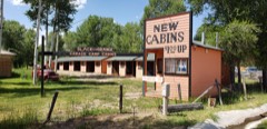 | Black and Orange Cabins | building | 2020 | 100005191 |
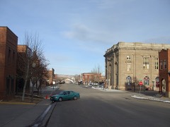 | Downtown Evanston Historic District | district | 1983 | 83004307 |
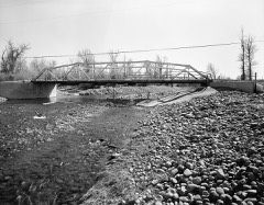 | ERT Bridge over Black's Fork | structure | 1985 | 85000441 |
| Fort Bridger | site | 1969 | 69000197 | |
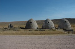 | Piedmont Charcoal Kilns | site | 1971 | 71000894 |
 | A. V. Quinn House | building | 1984 | 84003712 |
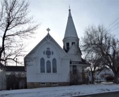 | St. Paul's Episcopal Church | building | 1980 | 80004057 |
 | US Post Office-Evanston Main | building | 1987 | 87000790 |
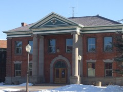 | Uinta County Courthouse | building | 1977 | 77001385 |
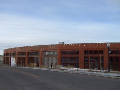 | Union Pacific Railroad Complex | district | 1985 | 85000685 |
| Union Pacific Railroad Complex (Additional Documentation) | building | 2005 | 05000708 | |
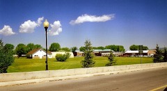 | Wyoming State Insane Asylum | district | 2003 | 03000084 |
Every wildfire the federal occurrence database records inside this county: 282 of them, burning about 12,822 acres. 84 started naturally and 3 were recorded as arson. Each settlement page carries the fires within five miles of it.
| Reported cause | Fires |
|---|---|
| Natural | 84 |
| Missing data/not specified/undetermined | 78 |
| Debris and open burning | 36 |
| Equipment and vehicle use | 21 |
| Power generation/transmission/distribution | 15 |
| Fireworks | 12 |
| Recreation and ceremony | 10 |
| Misuse of fire by a minor | 10 |
| Railroad operations and maintenance | 9 |
| Smoking | 4 |
| Arson/incendiarism | 3 |
The five largest, by the area the report gives. None of them was recorded as arson.
| Date | Cause | Size | Reported by | Name on the report |
|---|---|---|---|---|
| 18 September 2010 | Missing data/not specified/undetermined | 5,261 acres | Kemmerer Field Office | WINDMILL |
| 9 September 2017 | Power generation/transmission/distribution | 1,592 acres | Kemmerer Field Office | COWBOY |
| 28 July 2016 | Recreation and ceremony | 1,287 acres | Kemmerer Field Office | TOKEWANNA |
| 17 August 1994 | Natural | 790 acres | Rock Springs Field Office | BIGELOW BC |
| 25 July 2000 | Natural | 700 acres | Rock Springs Field Office | VACA |
| 12 August 2020 | Power generation/transmission/distribution | 605 acres | Kemmerer Field Office | PAINTER |
| 16 August 1994 | Natural | 600 acres | Rock Springs Field Office | RED CANYON |
| 13 October 1999 | Smoking | 420 acres | Uinta-Wasatch-Cache National Forest | LAMBS MEADOW |
Every settlement page carries the fires within five miles of it - see the settlement index below.
The NOAA Storm Events Database holds 82 reports for this county, causing no deaths, no injuries and about $70,280 in recorded property damage. Each settlement page carries the reports that name it.
| Kind of event | Reports |
|---|---|
| Thunderstorm Wind | 74 |
| Tornado | 4 |
| Hail | 3 |
| Flood | 1 |
The most serious of them, by death, then injury, then recorded damage. The accounts are quoted exactly as the forecast office filed them.
| When | Event | Place named | Harm | What the report says |
|---|---|---|---|---|
| July 1994 | Thunderstorm Wind | Evanston | $50,000 | Thunderstorm winds estimated at 70 mph struck Evanston late on the 4th. Several trees were blown down and a large branch was blown onto a bathroom at the Bear River State Park causing $10,000 damage. |
| June 2010 | Flood | Milburne | $10,000 | Flooding occurred on both the Black's Fork and the Smith's Fork Rivers, with flooding reported near both Robertson and Mountain View, Wyoming, though not much damage was reported. The Black's Fork river gauge rose the most during this event, peaking at 3642 cfs. |
| July 2023 | Thunderstorm Wind | Altamont | $5,000 | Multiple trees were downed approximately 11 miles south southwest of Altamont. |
| May 1989 | Tornado (F0) | not stated | $2,500 | no account filed |
| May 1962 | Tornado (F0) | not stated | $2,500 | no account filed |
| July 2023 | Thunderstorm Wind | Evanston | $250 | A school crossing sign was blown off of a pole. |
| May 1950 | Tornado (F2) | not stated | $30 | no account filed |
| April 2026 | Thunderstorm Wind | Evanston | - | A strong thunderstorm brought multiple severe gusts measured by the Evanston-Uinta County Airport - Burns Field ASOS. The first severe gust, which occurred at 1455, was measured at 59mph. This was then followed by a gust to 64mph at 1457, followed by the third and final severe gust to 64mph at 1502 as multiple storms tracked over Evanston, WY. |
| April 2026 | Thunderstorm Wind | Almy | - | A strong thunderstorm produced a severe wind gust to 69mph at the N7SHZ Medicine Butt Mountain WY US CWOP site. |
| April 2026 | Thunderstorm Wind | Spring Vly | - | A strong thunderstorm produced a severe gust to 66mph at the WYDOT First Divide sensor. |
| April 2026 | Thunderstorm Wind | Ragen | - | A strong thunderstorm produced multiple severe wind gusts to 58mph at the WYDOT I80 - Coal Road sensor. |
| April 2026 | Thunderstorm Wind | Verne | - | A strong thunderstorm produced multiple severe wind gusts at the VERNE1 UPR station. The first two severe wind gusts were to 70mph, followed by the third and final gust to 60mph. |
| May 2025 | Thunderstorm Wind | Almy | - | The Evanston North mesonet station recorded a wind gust of 59 mph as a result of outflow winds associated with a nearby cluster of showers and thunderstorms moving through the area. |
| May 2025 | Thunderstorm Wind | Almy | - | The Evanston North mesonet station recorded an initial strong wind gust of 58 mph at 2:30 pm MST, followed by a subsequent peak wind gust of 62 mph at 3:00 pm MST, and a final strong wind gust of 58 mph at 3:20 pm MST. More modest wind gusts in the 50 mph to 57 mph were recorded in between these observations. These wind gusts were the result of outflow winds associated with a nearby cluster of showers and thunderstorms moving through the area. |
| May 2025 | Thunderstorm Wind | Antelope | - | The Muddy Creek mesonet station recorded a wind gust of 66 mph as a result of outflow winds associated with a nearby cluster of showers and thunderstorms moving through the area. |
| July 2025 | Thunderstorm Wind | Spring Vly | - | The I80/US189 - First Divide mesonet station recorded a period of wind gusts to 59 mph as a result of outflow winds associated with a nearby cluster of showers and thunderstorms moving through the area. |
| July 2025 | Thunderstorm Wind | Spring Vly | - | The I80/US189 - First Divide mesonet station recorded a period of wind gusts to 60 mph as a result of outflow winds associated with a nearby cluster of showers and thunderstorms moving through the area. |
| July 2025 | Thunderstorm Wind | Evanston | - | The Evanston-Uinta County Airport - Burns Field ASOS (KEVW) station recorded a period of wind gusts to 70 mph as a result of outflow winds associated with a nearby cluster of showers and thunderstorms moving through the area. |
| July 2025 | Thunderstorm Wind | Almy | - | The N7SHZ Medicine Butt Mountain mesonet station recorded a period of severe wind gusts with a peak wind gust of 87 mph at 5:57 pm MST as a result of outflow winds associated with a nearby cluster of showers and thunderstorms moving through the area. |
| July 2025 | Thunderstorm Wind | Almy | - | The Evanston North mesonet station recorded a wind gust of 64 mph as a result of outflow winds associated with a nearby cluster of showers and thunderstorms moving through the area. |
| July 2025 | Thunderstorm Wind | Almy | - | The Evanston North mesonet station recorded a wind gust of 63 mph as a result of outflow winds associated with a nearby cluster of showers and thunderstorms moving through the area. |
| July 2025 | Thunderstorm Wind | Leroy | - | The I80 - Leroy mesonet station recorded a period of wind gusts to 62 mph as a result of outflow winds associated with a nearby cluster of showers and thunderstorms moving through the area. |
| July 2025 | Thunderstorm Wind | Leroy | - | The I80 - French mesonet station recorded a period of wind gusts to 80 mph as a result of outflow winds associated with a nearby cluster of showers and thunderstorms moving through the area. |
| July 2025 | Thunderstorm Wind | Ft Bridger Arpt | - | The Fort Bridger WY AWOS (KFBR) recorded a wind gust of 74 mph as a result of outflow winds associated with a nearby cluster of showers and thunderstorms moving through the area. |
| July 2025 | Thunderstorm Wind | Antelope | - | The MUDDY CREEK RAWS recorded a wind gust of 65 mph as a result of outflow winds associated with a nearby cluster of showers and thunderstorms moving through the area. |
| July 2025 | Thunderstorm Wind | Spring Vly | - | The I80/US189 - First Divide mesonet station recorded a period of wind gusts to 60 mph as a result of outflow winds associated with a nearby cluster of showers and thunderstorms moving through the area. |
| July 2025 | Thunderstorm Wind | Almy | - | The Evanston North mesonet station recorded a wind gust of 61 mph as a result of outflow winds associated with a nearby cluster of showers and thunderstorms moving through the area. |
| July 2025 | Thunderstorm Wind | Almy | - | The Evanston North mesonet station recorded a wind gust of 72 mph as a result of outflow winds associated with a likely dry microburst associated with a line of weak showers. |
| July 2025 | Thunderstorm Wind | Almy | - | The N7SHZ Medicine Butt Mountain mesonet station recorded a wind gust of 67 mph as a result of outflow winds associated with a nearby cluster of showers and thunderstorms moving through the area. |
| July 2025 | Thunderstorm Wind | Almy | - | The N7SHZ Medicine Butt Mountain mesonet station recorded a wind gust of 63 mph as a result of outflow winds associated with a likely dry microburst associated with a line of weak showers. |
| June 2024 | Thunderstorm Wind | Church Buttes | - | A wind gust of 59 mph was measured at the Church Butte mesonet station. |
| June 2024 | Thunderstorm Wind | Evanston | - | A wind gust of 61 mph was measured by the WY7 mesonet station in Evanston. |
| June 2024 | Thunderstorm Wind | Spring Vly | - | A wind gust of 62 mph was measured by the I80/US189 - First Divide mesonet site. |
| June 2024 | Thunderstorm Wind | Evanston | - | A wind gust of 58 mph was measured by the Evanston-Uinta County Airport - Burns Field ASOS. |
| June 2024 | Thunderstorm Wind | Ft Bridger Arpt | - | A wind gust of 63 mph was recorded by the Fort Bridger Airport AWOS. |
| September 2024 | Thunderstorm Wind | Almy | - | The Evanston North mesonet station recorded a wind gust of 73 mph as a result of outflow winds associated with a nearby cluster of showers and thunderstorms moving through the area. |
| August 2024 | Thunderstorm Wind | Evanston | - | A wind gust of 60 mph was recorded at the Evanston-Uinta County Airport - Burns Field ASOS. |
| August 2024 | Thunderstorm Wind | Almy | - | A wind gust of 72 mph was recorded at the Medicine Butte mesonet site. |
| August 2024 | Thunderstorm Wind | Almy | - | A wind gust of 58 mph was recorded at the Evanston North mesonet site. |
| August 2024 | Thunderstorm Wind | Verne | - | A wind gust of 65 mph was recorded at the Verne1 mesonet site. |
| September 2024 | Thunderstorm Wind | Evanston | - | The Evanston-Uinta County Airport - Burns Field ASOS recorded wind gusts of 60 mph as a result of outflow winds associated with a nearby cluster of showers and thunderstorms moving through the area. |
| September 2024 | Thunderstorm Wind | Almy | - | The Evanston-Uinta County Airport - Burns Field ASOS recorded a period of wind gusts to 70 mph between 4:19 pm MST and 4:28 pm MST, followed by an additional period of gusts to 59 mph between 4:32 pm MST and 5:40 pm MST. These gusts were the result of outflow winds associated with a nearby cluster of showers and thunderstorms moving through the area. |
| July 2024 | Thunderstorm Wind | Almy | - | The N7SHZ Medicine Butt Mountain mesonet station recorded an initial peak wind gust of 69 mph and a subsequent gust of 64 mph as a result of outflow winds associated with a nearby cluster of showers and thunderstorms moving through the area. |
| July 2024 | Thunderstorm Wind | Hampton | - | The HAMPT1 mesonet station recorded a wind gust of 58 mph as a result of outflow winds associated with a nearby cluster of showers and thunderstorms moving through the area. |
| July 2024 | Thunderstorm Wind | Evanston | - | The Evanston-Uinta County Airport - Burns Field ASOS recorded a wind gust of 59 mph as a result of outflow winds associated with a nearby cluster of showers and thunderstorms moving through the area. |
| July 2023 | Thunderstorm Wind | Leroy | - | The I80 - Leroy mesonet station recorded a period of wind gusts to 65 mph as a result of outflow winds associated with a nearby cluster of showers and thunderstorms moving through the area. |
| July 2023 | Thunderstorm Wind | Evanston | - | The Evanston-Uinta County Airport - Burns Field ASOS recorded a period of wind gusts up to 73 mph between 5:58 pm and 7:09 pm MST. The gusts were the result of outflow winds associated with a line of showers and thunderstorms moving through the area. |
| July 2023 | Thunderstorm Wind | Church Buttes | - | The I80 - Church Butte mesonet station recorded a period of wind gusts to 66 mph as a result of outflow winds associated with decaying thunderstorms in the area. |
| August 2021 | Thunderstorm Wind | Leroy | - | The Interstate 80 - French automated weather station recorded a peak wind gust of 58 mph. |
| August 2021 | Thunderstorm Wind | Spring Vly | - | The Interstate 80/U.S. Highway 189 - First Divide automated weather station recorded a peak wind gust of 78 mph. |
| August 2021 | Thunderstorm Wind | Antelope | - | The Muddy Creek automated weather station recorded a peak wind gust of 58 mph. |
| September 2021 | Thunderstorm Wind | Evanston | - | The Interstate 80/U.S. Highway 189 Evanston of Entry automated weather station recorded gusts of 60 and 58 mph. |
| September 2021 | Thunderstorm Wind | Evanston | - | The Evanston-Uinta County Airport - Burns Field automated weather station record a peak wind gust of 71 mph. |
| June 2020 | Thunderstorm Wind | Evanston | - | The Evanston-Uinta County Airport - Burns Field ASOS recorded a peak wind gust of 60 mph. |
| June 2020 | Thunderstorm Wind | Leroy | - | The French sensor recorded a peak wind gust of 62 mph. |
| June 2020 | Thunderstorm Wind | Church Buttes | - | The I80 - Church Butte sensor recorded a peak wind gust of 58 mph. |
| June 2020 | Thunderstorm Wind | Leroy | - | The Leroy sensor recorded a peak wind gust of 63 mph. |
| June 2020 | Thunderstorm Wind | Church Buttes | - | The I80 - Church Butte sensor recorded a peak wind gust of 62 mph. |
| June 2020 | Thunderstorm Wind | Antelope | - | The Muddy Creek RAWS sensor recorded a peak wind gust of 58 mph. |
| June 2020 | Hail | Leroy | - | Quarter-sized hail was reported on state Route 189, 1.5 miles north of Interstate 80. |
The Survey's mineral resources record lists 70 workings inside this county. 4 still produce and 66 are closed or unrecorded. Each settlement page carries the workings within five miles of it.
| Commodity | Workings |
|---|---|
| Sand and Gravel, Construction | 60 |
| Uranium | 4 |
| Clay | 3 |
| Bentonite | 2 |
| Titanium, Metal | 1 |
| Iron | 1 |
| Thorium, Zirconium | 1 |
The least common of them first, because a county's hundredth gravel pit says nothing its first ten did not.
| Where | Site | Commodity | Status | Recorded |
|---|---|---|---|---|
| Cumberland Gap Area | Titanium, Metal, Iron, Thorium, Zirconium | Occurrence | ||
| Jamison Claim | Bentonite | Past Producer | ||
| Scully Gap | Bentonite | Occurrence | ||
| Unknown | Clay | Occurrence | ||
| Unknown Claypit (Interpace Holdings, LLC) | Clay | Producer | Clay | |
| Unknown Claypit (Interstate Brick) | Clay | Producer | ||
| Bear River | Uranium | Unknown | ||
| Carnotite B-1 | Uranium | Prospect | ||
| Oyster Ridge | Uranium | Unknown | ||
| Unknown | Uranium | Occurrence | ||
| Bluemel and Fraughton | Sand and Gravel, Construction | Producer | ||
| Ellingford Brothers | Sand and Gravel, Construction | Producer | ||
| Unknown Borrow Pit | Sand and Gravel, Construction | Past Producer | ||
| Unknown Borrow Pit | Sand and Gravel, Construction | Unknown | ||
| Unknown Borrow Pit | Sand and Gravel, Construction | Unknown | ||
| Unknown Borrow Pit | Sand and Gravel, Construction | Past Producer | ||
| Unknown Borrow Pit | Sand and Gravel, Construction | Past Producer | ||
| Unknown Borrow Pit | Sand and Gravel, Construction | Unknown | ||
| Unknown Gravel Pit | Sand and Gravel, Construction | Past Producer | ||
| Unknown Gravel Pit | Sand and Gravel, Construction | Unknown | ||
| Unknown Gravel Pit | Sand and Gravel, Construction | Unknown | ||
| Unknown Gravel Pit | Sand and Gravel, Construction | Unknown | ||
| Unknown Gravel Pit | Sand and Gravel, Construction | Unknown | ||
| Unknown Gravel Pit | Sand and Gravel, Construction | Past Producer | ||
| Unknown Gravel Pit | Sand and Gravel, Construction | Past Producer | ||
| Unknown Gravel Pit | Sand and Gravel, Construction | Unknown | ||
| Unknown Gravel Pit | Sand and Gravel, Construction | Unknown | ||
| Unknown Gravel Pit | Sand and Gravel, Construction | Past Producer | ||
| Unknown Gravel Pit | Sand and Gravel, Construction | Past Producer | ||
| Unknown Gravel Pit | Sand and Gravel, Construction | Past Producer | ||
| Unknown Gravel Pit | Sand and Gravel, Construction | Past Producer | ||
| Unknown Gravel Pit | Sand and Gravel, Construction | Past Producer | ||
| Unknown Gravel Pit | Sand and Gravel, Construction | Past Producer | ||
| Unknown Gravel Pit | Sand and Gravel, Construction | Past Producer | ||
| Unknown Gravel Pit | Sand and Gravel, Construction | Past Producer | ||
| Unknown Gravel Pit | Sand and Gravel, Construction | Past Producer | ||
| Unknown Gravel Pit | Sand and Gravel, Construction | Past Producer | ||
| Unknown Gravel Pit | Sand and Gravel, Construction | Past Producer | ||
| Unknown Gravel Pit | Sand and Gravel, Construction | Past Producer | ||
| Unknown Gravel Pit | Sand and Gravel, Construction | Past Producer | ||
| Unknown Gravel Pit | Sand and Gravel, Construction | Past Producer | ||
| Unknown Gravel Pit | Sand and Gravel, Construction | Unknown | ||
| Unknown Gravel Pit | Sand and Gravel, Construction | Past Producer | ||
| Unknown Gravel Pit | Sand and Gravel, Construction | Unknown | ||
| Unknown Gravel Pit | Sand and Gravel, Construction | Past Producer | ||
| Unknown Gravel Pit | Sand and Gravel, Construction | Past Producer | ||
| Unknown Gravel Pit | Sand and Gravel, Construction | Unknown | ||
| Unknown Gravel Pit | Sand and Gravel, Construction | Past Producer | ||
| Unknown Gravel Pit | Sand and Gravel, Construction | Past Producer | ||
| Unknown Gravel Pit | Sand and Gravel, Construction | Unknown | ||
| Unknown Gravel Pit | Sand and Gravel, Construction | Unknown | ||
| Unknown Gravel Pit | Sand and Gravel, Construction | Unknown | ||
| Unknown Gravel Pit | Sand and Gravel, Construction | Unknown | ||
| Unknown Gravel Pit | Sand and Gravel, Construction | Unknown | ||
| Unknown Gravel Pit | Sand and Gravel, Construction | Unknown | ||
| Unknown Gravel Pit | Sand and Gravel, Construction | Unknown | ||
| Unknown Gravel Pit | Sand and Gravel, Construction | Unknown | ||
| Unknown Gravel Pit | Sand and Gravel, Construction | Unknown | ||
| Unknown Gravel Pit | Sand and Gravel, Construction | Unknown | ||
| Unknown Gravel Pits | Sand and Gravel, Construction | Unknown | ||
| Unknown Gravel Pits | Sand and Gravel, Construction | Unknown | ||
| Unknown Gravel Pits | Sand and Gravel, Construction | Unknown | ||
| Unknown Gravel Pits | Sand and Gravel, Construction | Unknown | ||
| Unknown Gravel Pits | Sand and Gravel, Construction | Past Producer | ||
| Unknown Gravel Pits | Sand and Gravel, Construction | Unknown |
Named settlements recorded in the Geographic Names Information System, each with the topographic sheets covering it. Villages, hamlets and abandoned places alike. Each is shown with the nearest named watercourse or landform and the survey quadrangle it falls on.
Evanston census division · 82930 · On Red Canyon Creek · Murphy Ridge quadrangle
9 sheets, 1954 to 1991
Evanston census division · 82930 · Near Choppy Draw · Sulphur Creek Reservoir quadrangle
8 sheets, 1954 to 1980
Evanston census division · 82930 · Near Murphy Ridge · Neponset Reservoir NE quadrangle
9 sheets, 1954 to 1991
Evanston census division · 82930 · On Bazoo Hollow Creek · Sulphur Creek Reservoir quadrangle
8 sheets, 1954 to 1980
Bridger Valley census division · Near Coal Mine Draw · Bridger quadrangle
8 sheets, 1954 to 1980
Bridger Valley census division · On Antelope Creek · Ragan quadrangle
9 sheets, 1954 to 1980
Evanston census division · 82930 · Near Hamblin Park · Evanston quadrangle
9 sheets, 1954 to 1980
Bridger Valley census division · 82933 · On Groshon Creek · Fort Bridger quadrangle
10 sheets, 1954 to 1980
Bridger Valley census division · On Little Muddy Creek · Hampton quadrangle
8 sheets, 1954 to 1979
Evanston census division · 82930 · On LaChapelle Creek · Sulphur Creek Reservoir quadrangle
8 sheets, 1954 to 1980
Bridger Valley census division · 82936 · On Carter Spring Creek · Lonetree quadrangle
8 sheets, 1954 to 1980
Bridger Valley census division · 82933 · On Sixmile Creek · Fort Bridger quadrangle
10 sheets, 1954 to 1980
Bridger Valley census division · 82939 · On Smiths Fork · Mountain View quadrangle
8 sheets, 1954 to 1980
Evanston census division · On Piedmont Creek · Piedmont Reservoir quadrangle
8 sheets, 1954 to 1980
Bridger Valley census division · 82944 · On Willow Creek · Robertson quadrangle
8 sheets, 1954 to 1980
Evanston census division · 82930 · On Middle Fork Fowkes Canyon Creek · Three Forks quadrangle
9 sheets, 1954 to 1980
Bridger Valley census division · Near Caterpillar Draw · Verne quadrangle
8 sheets, 1954 to 1979