 Block
From the record
7 National Register listings published here.
Sources: the National Register database, National Park Service
42 topographic sheets cover 11 settlements here, and 7 properties are on the National Register of Historic Places.
7 National Register listings published here.
Sources: the National Register database, National Park Service
Every property in this county listed on the National Register of Historic Places, with the year it was listed and the federal nomination document.
| Photograph | Property | Type | Listed | Reference |
|---|---|---|---|---|
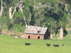 | Ainsworth House | building | 1986 | 86002321 |
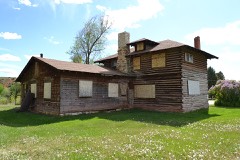 | Emerson Parks House | building | 2016 | 16000265 |
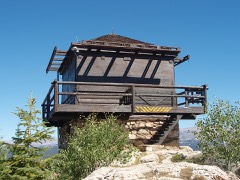 | James T. Saban Lookout | structure | 2016 | 16000781 |
 | Ten Sleep Mercantile | building | 1986 | 86002324 |
 | West Side School | building | 2021 | 100007002 |
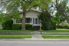 | Worland House | building | 1986 | 86000310 |
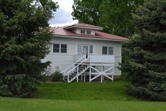 | Worland Ranch | district | 1992 | 92000123 |
Every wildfire the federal occurrence database records inside this county: 890 of them, burning about 166,269 acres. 304 started naturally and 8 were recorded as arson. Each settlement page carries the fires within five miles of it.
| Reported cause | Fires |
|---|---|
| Natural | 304 |
| Missing data/not specified/undetermined | 236 |
| Fireworks | 147 |
| Debris and open burning | 100 |
| Equipment and vehicle use | 42 |
| Recreation and ceremony | 20 |
| Power generation/transmission/distribution | 18 |
| Arson/incendiarism | 8 |
| Smoking | 6 |
| Railroad operations and maintenance | 4 |
| Misuse of fire by a minor | 4 |
| Firearms and explosives use | 1 |
The five largest, by the area the report gives. None of them was recorded as arson.
| Date | Cause | Size | Reported by | Name on the report |
|---|---|---|---|---|
| 8 July 2018 | Natural | 42,267 acres | Worland Field Office | TEREK FIRE |
| 25 August 1996 | Natural | 38,858 acres | Worland Field Office | BATES |
| 14 July 2020 | Missing data/not specified/undetermined | 17,559 acres | Wind River / Bighorn Basin District | NEIBER |
| 13 August 2018 | Natural | 4,905 acres | Worland Field Office | DENVER JAKE |
| 25 August 1996 | Natural | 4,793 acres | Worland Field Office | WILLOW |
| 17 August 1996 | Natural | 4,525 acres | Worland Field Office | CEDAR RIDG |
| 26 June 2012 | Natural | 3,926 acres | Worland Field Office | UPPER BEE |
| 28 July 2018 | Natural | 3,856 acres | Worland Field Office | ZIMMERMAN |
Every settlement page carries the fires within five miles of it - see the settlement index below.
The NOAA Storm Events Database holds 144 reports for this county, causing no deaths, 1 injury and about $764,700 in recorded property damage. Each settlement page carries the reports that name it.
| Kind of event | Reports |
|---|---|
| Thunderstorm Wind | 59 |
| Hail | 49 |
| Funnel Cloud | 12 |
| Flood | 10 |
| Tornado | 8 |
| Flash Flood | 6 |
The most serious of them, by death, then injury, then recorded damage. The accounts are quoted exactly as the forecast office filed them.
| When | Event | Place named | Harm | What the report says |
|---|---|---|---|---|
| July 1995 | Thunderstorm Wind | Worland | 1 hurt | Strong thunderstorm winds downed tree limbs in Worland. One 3 inch diameter branch was blown 60 feet, striking a person in the head. |
| March 2014 | Flood | (Wrl)Worland Muni Ar | $250,000 | Ice jam flooding caused damage in Worland. Neighborhoods near the river north and south of the Highway 789 bridge reported flooding of some homes. The water extended 100-200 yards from the river's edge at a depth of 12 to 18 inches. |
| February 2017 | Flood | Worland | $100,000 | Rapidly warming temperatures after a prolonged cold spell, rapidly melted snow in the Big Horn Basin. This, combined with the frozen Big Horn River breaking up, produced flooding in Washakie County, especially in the vicinity of Worland. Over 100 homes were evacuated in the low lying residential areas along the river. Some residents were out of their homes for three days before finally being allowed back as the water receded on February 14th. The water receded after February 15th as the ice jam moved northward into Big Horn County. |
| June 2011 | Flood | Ten Sleep Arpt | $100,000 | Temperatures approaching 70 degrees around 9,500 feet melted snow and caused the water level on Tensleep Creek to quickly rise during the overnight hours of June 29 and 30. The flood waters washed out a road leading to the Wigwam Fish Rearing Station and to a private residence near the mouth of Tensleep Canyon east of town. Several residents also reported flooding of their yards and at least one reported an out-building being inundated by water. |
| August 2010 | Tornado (EF1) | Ten Sleep Arpt | $70,000 | A tornado swept through Juniper trees on a high ridge before descending the hillside into the Nowood River Valley southeast of Ten Sleep. The tornado destroyed several well-built out buildings and downed at least 20, century-old Cottonwood trees on ranches in the valley. |
| March 2014 | Flood | Durkee | $50,000 | Flooding of two ranches occurred along the Nowood River north of Ten Sleep. The ice jams formed on several bends in the serpentine river flooding ranch lands. At least one resident evacuated their residence as the water level climbed. |
| August 2010 | Thunderstorm Wind | Ten Sleep | $50,000 | Ping pong ball sized hail driven by wind gusts estimated to be around 85 mph damaged roofs, rain gutters, windows, and siding of several homes in the Nowood River Valley south of Ten Sleep. The wind also ripped metal roofing from a garage, while another garage was significantly damaged by a toppled Cottonwood tree. A rear flank downdraft associated with a nearby supercell thunderstorm was responsible for the damaging wind. |
| August 2007 | Flash Flood | Winchester | $35,000 | Heavy rain caused mud, rocks, and water to spread from higher terrain south across Little Cottonwood Creek Road. At least one culvert and part of the road were to be replaced following the flash flood. The basement of one ranch house about six miles west of Winchester was inundated by the flood waters and mud. |
| August 2010 | Hail | Ten Sleep | $30,000 | Ping pong ball sized hail fell for several minutes at ranches just west of State Highway 434. Substantial damage was done to the sorghum crop at one ranch. |
| June 2018 | Tornado (EF2) | Ten Sleep | $20,000 | An EF-2 tornado with maximum winds at 130 mph touched down in Northeast Washakie county in a heavily forested area at around 8000 feet. The tornado downed and snapped off around 1,000 trees near ground level during its short path. |
| July 2011 | Thunderstorm Wind | Worland | $20,000 | Thunderstorm outflow wind toppled 15 to 20 power poles in the town of Worland. A fence at the Bureau of Land Management office was also blown over. |
| June 2011 | Flood | Ten Sleep Arpt | $15,000 | The waters of Tensleep Creek rose rapidly during the early morning hours of Friday, June 24. The basements of several homes east of Ten Sleep were impacted by the flood waters. |
| June 2017 | Thunderstorm Wind | Worland | $10,000 | The Worland airport reported a thunderstorm wind gust to 69 mph. This led to many trees and power lines being blown down in the city of Worland. The hardest hit areas were between South 10th and South 15th street as well as between Culbertson and Washakie Streets. A gust of 65 mph was measured at the Leigh Creek RAWS site. |
| June 2005 | Thunderstorm Wind | Ten Sleep | $10,000 | no account filed |
| June 1976 | Tornado (F0) | not stated | $2,500 | no account filed |
| July 2025 | Thunderstorm Wind | Worland | $2,000 | A weather station 12 miles east of Worland reported a wind gust of 70 mph. In Worland, trees and power lines were reported down. A 5 inch limb fell on a home. |
| August 1995 | Thunderstorm Wind | Worland | $200 | Thunderstorm winds blew down trees and limbs and tangled some power lines in tree branches around Worland. |
| July 2025 | Thunderstorm Wind | (Wrl)Worland Muni Ar | - | A 59 mph wind gust was reported at the Pistol Draw RAWS site. |
| August 2025 | Thunderstorm Wind | Worland | - | Wind gusts as high as 71 mph were reported east of Worland. |
| August 2025 | Thunderstorm Wind | Worland | - | Wind gusts as high as 71 mph occurred near and to the east of Worland. |
| June 2024 | Thunderstorm Wind | (Wrl)Worland Muni Ar | - | The Washakie County emergency manager reported numerous trees down to the southwest of Worland. |
| August 2024 | Thunderstorm Wind | (Wrl)Worland Muni Ar | - | Wind gusts as high as 62 mph were reported at the Worland airport. The strong wind gusts brought down tree limbs in the city of Worland. |
| April 2023 | Thunderstorm Wind | (Wrl)Worland Muni Ar | - | A 61 mph wind gust was reported at the Worland airport as a line of thunderstorms passed. |
| September 2023 | Flash Flood | Nowood | - | Deputies reported some minor flooding over roadways in southeast portions of Washakie county. |
| June 2023 | Thunderstorm Wind | (Wrl)Worland Muni Ar | - | A 63 mph wind gust was reported at the Worland airport. |
| June 2021 | Thunderstorm Wind | Worland | - | Please see episode for narrative. |
| May 2021 | Funnel Cloud | Neiber | - | See episode for description. |
| July 2021 | Thunderstorm Wind | (Wrl)Worland Muni Ar | - | A 64 mph wind gust was recorded by the ASOS at Worland Municipal Airport. |
| August 2020 | Thunderstorm Wind | Winchester | - | Tree limbs 5 to 7 inches in diameter were downed in Winchester. |
| May 2019 | Thunderstorm Wind | (Wrl)Worland Muni Ar | - | The ASOS at the Worland airport reported a wind gust of 58 mph. |
| May 2019 | Flood | Worland | - | The Washakie County emergency manager reported street flooding in portions of Worland. |
| May 2019 | Flood | Ten Sleep | - | The Washakie County emergency manager reported two small mudslides in Ten Sleep Canyon. |
| May 2019 | Flood | Ten Sleep Arpt | - | A trained spotter reported minor flooding along Ten Sleep Creek. The water remained in low lying areas and caused no damage. |
| July 2019 | Hail | Neiber | - | Trained spotters reported nickel sized hail near Worland. |
| July 2019 | Thunderstorm Wind | (Wrl)Worland Muni Ar | - | The ASOS at the Worland, Wyoming airport reported a wind gust of 66 mph. |
| July 2019 | Thunderstorm Wind | Big Trails | - | A trained spotter reported a wind gust of 64 mph at Big Trails, Wyoming. |
| July 2019 | Thunderstorm Wind | Worland | - | A trained spotter reported tree and roof damage in Worland, Wyoming. Several tree limbs were blown down to the north-northwest of Ten Sleep, Wyoming. |
| August 2019 | Flash Flood | Worland | - | Over an inch of rain along with small hail fell in Worland in only 25 minutes and brought street flooding. The water closed some streets for a while and water also backed into some buildings, including the city shop. |
| June 2018 | Hail | Winchester | - | The public reported nickel size hail in Winchester. |
| June 2018 | Hail | Ten Sleep | - | The CO-OP Observer near Big Trails reported half dollar to ping pong ball size hail 3 miles north of Big Trails. |
| July 2018 | Flash Flood | Durkee | - | A combination of very heavy rain, large amounts of small hail and a clogged culvert brought flash flooding east of Worland. Around 2 feet of water was running over US 16. The flooding was alleviated after the clog in the Culvert was cleared. |
| May 2018 | Flood | Ten Sleep | - | Washakie County sheriff deputies reported flooding around the Ten Sleep Creek bridge along Highway 16. The water flooded several campsites. The water also got close to surface of the bridge but never topped it. |
| August 2018 | Thunderstorm Wind | (Wrl)Worland Muni Ar | - | The ASOS at the Worland airport reported a wind gust of 59 mph from a collapsing thunderstorm. |
| June 2018 | Funnel Cloud | Worland | - | Trained spotters reported a funnel cloud northwest of Worland. |
| June 2018 | Hail | Ten Sleep | - | A storm chaser reported ping pong ball size hail near Ten Sleep. |
| June 2017 | Hail | Ten Sleep | - | The public reported quarter size hail to the east of Ten Sleep. |
| July 2015 | Thunderstorm Wind | Nowood | - | Weak convection and a strong pressure gradient combined to produce a peak wind gust of 76 mph shortly before 1500MST at the Split Rock Creek RAWS. |
| September 2014 | Thunderstorm Wind | (Wrl)Worland Muni Ar | - | The ASOS at the Worland Municipal Airport clocked a 58 mph wind gust from the west at 1224MST as a thunderstorm rolled east across Washakie County. |
| May 2014 | Hail | Worland | - | Hail to the size of pennies was reported in Worland. |
| May 2014 | Thunderstorm Wind | (Wrl)Worland Muni Ar | - | The ASOS at the Worland Airport reported a wind gust of 65 mph from a weak shower sweeping northeast. |
| May 2014 | Thunderstorm Wind | Ten Sleep Arpt | - | Shingles were blown off the roof of a ranch house north of Ten Sleep. |
| June 2014 | Hail | Winchester | - | The community of Winchester was hit with three to four minutes of nickel to quarter sized hail. |
| July 2013 | Thunderstorm Wind | Durkee | - | Wind gusts estimated at 60 mph combined with one-half inch diameter hail to devastate barley and corn fields in northern Washakie County. There were a few cottonwood trees downed by the wind, one of which fell across State Highway 433. The same thunderstorm caused one irrigation ditch to fill quickly and produce minor flooding of a nearby road. |
| June 2013 | Hail | Ten Sleep Arpt | - | A trained spotter reported nickel sized hail along the Nowood River Road northwest of Ten Sleep. |
| May 2013 | Hail | Winchester | - | A trained spotter reported hail the size of quarters covering the ground. |
| May 2013 | Funnel Cloud | Durkee | - | A trained spotter reported several funnel clouds as well as a rotating wall cloud north of Worland. |
| May 2013 | Hail | Ten Sleep Arpt | - | Hail up to one inch in diameter fell at a ranch 9 miles northwest of Ten Sleep. |
| May 2013 | Funnel Cloud | Worland | - | A funnel cloud was observed 12 miles west of Worland. |
| June 2012 | Thunderstorm Wind | (Wrl)Worland Muni Ar | - | Thunderstorm outflow produced a 64 mph wind gust at Worland Municipal Airport. |
| June 2011 | Hail | Ten Sleep | - | A trained spotter reported quarter sized hail at a ranch southeast of Ten Sleep. |
The Survey's mineral resources record lists 61 workings inside this county. 5 still produce and 56 are closed or unrecorded. Each settlement page carries the workings within five miles of it.
| Commodity | Workings |
|---|---|
| Sand and Gravel, Construction | 17 |
| Uranium | 14 |
| Gypsum-Anhydrite | 14 |
| Bentonite | 6 |
| Titanium-Heavy Minerals | 1 |
| Iron, Zirconium, Thorium | 1 |
| Thorium, Zirconium, Iron, Titanium, Metal | 1 |
| Talc-Soapstone | 1 |
| Tungsten | 1 |
| Titanium, Iron | 1 |
| Nitrogen-Nitrates | 1 |
| Asbestos | 1 |
| Magnesite | 1 |
| Manganese | 1 |
The least common of them first, because a county's hundredth gravel pit says nothing its first ten did not.
| Where | Site | Commodity | Status | Recorded |
|---|---|---|---|---|
| Canyon Creek Claim | Asbestos | Prospect | ||
| Canyon Creek Talc | Talc-Soapstone | Occurrence | ||
| Dugout Creek | Titanium-Heavy Minerals, Iron, Zirconium, Thorium | Occurrence | 1955 | |
| Dugout Creek | Titanium, Iron | Occurrence | 1955 | |
| Gheen Nos 1 and 2 Claims | Manganese | Prospect | Pyrolusite, Psilomelane, Braunite | |
| Mud Creek | Thorium, Zirconium, Iron, Titanium, Metal | Occurrence | 1906, 1920, 1955 | |
| Tensleep Canyon | Magnesite | Occurrence | ||
| Unknown | Tungsten | Prospect | ||
| Unknown | Nitrogen-Nitrates | Occurrence | ||
| Worland Betonite Mill | Clay | Producer | ||
| Bentonite Mine | Bentonite | Producer | ||
| Bud Kimball Creek | Bentonite | Occurrence | ||
| North Ten Sleep Mine | Bentonite | Producer | ||
| Northwest of Tensleep | Bentonite | Occurrence | ||
| Nowood River #5 | Bentonite | Occurrence | ||
| Unknown | Bentonite | Prospect | ||
| Anderson Claims and Adjacent Claims | Uranium | Occurrence | ||
| Big Trails Area | Gypsum-Anhydrite | Occurrence | ||
| Canyon Creek | Uranium | Occurrence | ||
| Gag Claims | Uranium | Occurrence | ||
| Gay Claims | Uranium | Occurrence | Stratabound | |
| Nowood River #1 | Gypsum-Anhydrite | Occurrence | ||
| Nowood River #2 | Gypsum-Anhydrite | Occurrence | ||
| Nowood River #3 | Gypsum-Anhydrite | Occurrence | ||
| Nowood River #4 | Gypsum-Anhydrite | Occurrence | ||
| Packer Group | Uranium | Past Producer | ||
| Scorpion Claims | Uranium | Past Producer | ||
| Spring Creek Area | Gypsum-Anhydrite | Occurrence | ||
| Ten Sleep Area | Gypsum-Anhydrite | Occurrence | ||
| Unknown | Uranium | Producer | Stratabound | |
| Unknown | Uranium | Occurrence | Stratabound | |
| Unknown | Uranium | Occurrence | Stratabound | |
| Unknown | Uranium | Occurrence | Stratabound | |
| Unknown | Gypsum-Anhydrite | Prospect | ||
| Unknown | Gypsum-Anhydrite | Occurrence | ||
| Unknown | Gypsum-Anhydrite | Prospect | ||
| Unknown | Uranium | Unknown | ||
| Unknown | Uranium | Unknown | ||
| Unknown | Gypsum-Anhydrite | Prospect | ||
| Unknown | Gypsum-Anhydrite | Occurrence | ||
| Unknown | Gypsum-Anhydrite | Prospect | ||
| Unknown | Uranium | Unknown | ||
| Unknown | Gypsum-Anhydrite | Prospect | ||
| Unknown | Uranium | Unknown | ||
| Big Horn Feeders | Sand and Gravel, Construction | Past Producer | ||
| County Pit | Sand and Gravel, Construction | Past Producer | ||
| Daugherty Pit | Sand and Gravel, Construction | Past Producer | ||
| Davis Pit #1 | Sand and Gravel, Construction | Past Producer | ||
| Davis Pit #2 | Sand and Gravel, Construction | Past Producer | ||
| Extended Breeder #2 | Sand and Gravel, Construction | Past Producer | ||
| Frison | Sand and Gravel, Construction | Past Producer | ||
| Gee | Sand and Gravel, Construction | Past Producer | ||
| Honk | Sand and Gravel, Construction | Past Producer | ||
| Howard Pit | Sand and Gravel, Construction | Past Producer | ||
| Mccormac Pit #1 | Sand and Gravel, Construction | Producer | ||
| Mileski | Sand and Gravel, Construction | Past Producer | ||
| Neiber Pit | Sand and Gravel, Construction | Past Producer | ||
| Star Pit | Sand and Gravel, Construction | Past Producer | ||
| State Mat Pit | Sand and Gravel, Construction | Past Producer | ||
| Tomis Pit | Sand and Gravel, Construction | Past Producer | ||
| Wyoming Game & Fish | Sand and Gravel, Construction | Past Producer |
Named settlements recorded in the Geographic Names Information System, each with the topographic sheets covering it. Villages, hamlets and abandoned places alike. Each is shown with the nearest named watercourse or landform and the survey quadrangle it falls on.
Worland census division · 82401 · Near Sand Knoll Draw · Banjo Flats West quadrangle
8 sheets, 1955 to 1979
Worland census division · 82401 · Near South Flat · Neiber quadrangle
10 sheets, 1945 to 1985
Ten Sleep census division · 82442 · On Middle Fork Little Canyon Creek · Horse Butte quadrangle
6 sheets, 1955 to 1979
Worland census division · 82401 · On South Flat · Neiber quadrangle
10 sheets, 1945 to 1985
Ten Sleep census division · 82442 · On Tensleep Creek · Ten Sleep quadrangle
17 sheets, 1899 to 1979
Worland census division · 82401 · On Cottonwood Creek · Kirby quadrangle
10 sheets, 1945 to 1985
Worland census division · 82401 · On Sage Creek · Worland quadrangle
10 sheets, 1955 to 1979