 Block
From the record
6 National Register listings published here.
Sources: the National Register database, National Park Service
212 topographic sheets cover 105 settlements here, and 6 properties are on the National Register of Historic Places.
6 National Register listings published here.
Sources: the National Register database, National Park Service
Every property in this county listed on the National Register of Historic Places, with the year it was listed and the federal nomination document.
| Photograph | Property | Type | Listed | Reference |
|---|---|---|---|---|
| First Mission House | building | 1990 | 90001551 | |
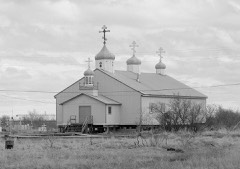 | St. Jacob's Church | building | 1980 | 80000748 |
| St. Nicholas Russian Orthodox Church | building | 1991 | 91000385 | |
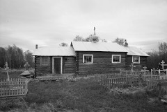 | St. Seraphim Chapel | building | 1980 | 80004586 |
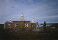 | St. Sergius Chapel | building | 1980 | 80004585 |
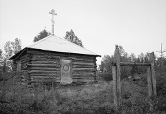 | Sts. Constantine and Helen Chapel | building | 1980 | 80004583 |
Every wildfire the federal occurrence database records inside this county: 426 of them, burning about 2,108,334 acres. 353 started naturally and 1 was recorded as arson. Each settlement page carries the fires within five miles of it.
| Reported cause | Fires |
|---|---|
| Natural | 353 |
| Missing data/not specified/undetermined | 40 |
| Debris and open burning | 12 |
| Recreation and ceremony | 10 |
| Other causes | 4 |
| Misuse of fire by a minor | 3 |
| Smoking | 1 |
| Firearms and explosives use | 1 |
| Arson/incendiarism | 1 |
| Equipment and vehicle use | 1 |
The five largest, by the area the report gives. None of them was recorded as arson.
| Date | Cause | Size | Reported by | Name on the report |
|---|---|---|---|---|
| 25 June 1997 | Natural | 606,945 acres | Alaska Fire Service | INOWAK |
| 31 May 2013 | Natural | 201,808 acres | Alaska Fire Service | LIME HILLS |
| 2 August 2005 | Natural | 82,123 acres | Alaska Fire Service | TALBIKSOK |
| 24 June 1997 | Natural | 71,760 acres | Southwest Area | TITNUK CREEK |
| 31 May 2015 | Natural | 67,778 acres | Alaska Fire Service | WHITEFISH LAKE 1 |
| 31 July 2005 | Natural | 60,732 acres | Alaska Fire Service | GEORGE |
| 22 June 2015 | Natural | 55,704 acres | Yukon Delta National Wildlife Refuge | 15547 NORTH ANIAK |
| 1 June 2015 | Natural | 48,728 acres | Lake Clark National Park and Preserve | CAN CREEK |
Every settlement page carries the fires within five miles of it - see the settlement index below.
The NOAA Storm Events Database holds 45 reports for this county, causing no deaths, no injuries and about $16,888,000 in recorded property damage. Each settlement page carries the reports that name it.
| Kind of event | Reports |
|---|---|
| Flood | 37 |
| Thunderstorm Wind | 3 |
| Tornado | 2 |
| Hail | 2 |
| Funnel Cloud | 1 |
The most serious of them, by death, then injury, then recorded damage. The accounts are quoted exactly as the forecast office filed them.
| When | Event | Place named | Harm | What the report says |
|---|---|---|---|---|
| October 2025 | Flood | Bethel | $10,000,000 | This flooding was caused by storm surge moving upriver in the intertidal zone, not by runoff from heavy rainfall. Flooding extended from Napakiak northeast to Bethel. River levels in Bethel reached 9.5 ft at 3:00 PM AKDT as recorded by the local gauge datum before it experienced an outage. After the event, a high water mark survey by the Division of Geological and Geophysical Surveys (DGGS) estimated the crest at 11.01 ft. Bethel saw a barge strike the Brown Slough Bridge. The Alaska State Emergency Operations Center (SEOC) reported no obvious structural damage was observed but Bridge is closed pending an inspection. The barge was carrying 400 gallons of fuel, but no spill was observed. Images from social media showed Bridge Avenue, as well as 6th and 7th Avenue flooded. Napakiak experienced the most severe flooding in recent memory. 20 homes floated from their foundations and flooding was experienced at the store. Houses were reported floating, and the power system was flooding. 40 - 50 people were evacuated to the high school, noted the SEOC. |
| May 2009 | Flood | Akiachak | $2,600,000 | no account filed |
| October 2025 | Flood | Quinhagak | $2,000,000 | This flooding was not caused by heavy rain, but by storm surge moving up along the Kuskokwim River into the intertidal zone. The community of Tuntutuliak experienced major flooding due to the surge flowing up into the Kuskokwim River channel, with the worst flooding observed near the time of normal high tide on the morning of October 12th. Based on early high water survey data conducted by the Department of Geological and Geophysical Survey, water levels reached several feet above the normal high tide height in Tuntutuliak, similar to what was observed father upstream along the Kuskokwim River. The Alaska State Emergency Operations Center (SEOC) reported that multiple homes were moved from their foundations by water and that an unknown volume of waste oil was spilled from a service station in the community as a result of the water inundation. |
| May 2011 | Flood | Crooked Creek | $1,500,000 | RFC personnel reported Ice Jam flooding along the Kuskokwim River starting in Red Devil from an ice jam near Eightmile. An Ice Jam then formed downstream of Crooked Creek causing flooding in that community. The flooding receded the night of May 12th in both communities. |
| May 2009 | Flood | Lower Kalskag | $500,000 | no account filed |
| May 2009 | Flood | Sleetmute | $110,000 | no account filed |
| May 2009 | Flood | Aniak | $100,000 | no account filed |
| May 2020 | Flood | Aniak | $50,000 | The catastrophic ice jam which began on 4/30 held through 5/4 at the Kolmakof River. As a result, 16 cabins and several other buildings were destroyed or submerged, and the airport was under with feet of water. Most damage occurred in the vicinity of the Native Village of Napaimute. |
| May 2009 | Flood | Crooked Creek | $15,000 | no account filed |
| May 2021 | Flood | Aniak | $10,000 | This ice jam was caused by some of the thickest ice on the river this winter - some local reports indicated that it was greater than 50 thick (most other reading along the Kuskokwim from last year are around 36). Ice became thicker in this region because of freeze up ice jams, where many layers of frazil ice accumulated. When the breakup front moved to below Aniak, this thick ice jammed. It held for 5 days and slowly backed up water to Aniak, and Aniak was on the verge of flooding from the back sloughs. There was water across the road circling the lower end of the runway, as well as flooding the gravel pit and barge landing area. |
| May 2009 | Flood | Sleetmute | $3,000 | no account filed |
| May 2025 | Flood | Kaltag | - | Staff from the Anchorage River Forecast Center spotted an ice jam downstream from Kalskag during their aerial river watch survey on the afternoon of May 5th. The ice jam caused water to rapidly rise and flood the road connecting the Upper Kalskag and Lower Kalskag communities. School children were taken back and forth by boat to travel between the two villages while flood waters were at their highest. By May 7th, the downstream ice jam broke up and allowed water levels to recede to normal levels. |
| May 2024 | Flood | Napakiak | - | NWS Riverwatch reported an ice jam had formed near Napakiak and the impounded water would be reported to flood most of the village of Napakiak. The warning was rolled into an additional warning for the reach from Napakiak upstream to Bethel. Widespread flooding of the tundra in addition to the villages along the Kuskokwim river would also be reported which caused flood waters to impound for longer periods of time without any path to drainage. |
| May 2024 | Flood | Lower Kalskag | - | Ice jam flooding had impounded water at a jam located below Kalskag, and the flooding had closed the road connecting Upper and Lower Kalskag impacting transportation in the area. Additional jams were backing up flows along Mud Creek which was impounding water surrounding Kalskag. Mud Creek backup would impact the gas station which had to cut power and close. |
| May 2024 | Flood | Kwethluk | - | Widespread ice jam flooding impacted Kwethluk. The Riverwatch team reported the widespread flooding in Kwethluk which would continue to increase in severity as colder temperatures slowed down the movement of the ice jam downstream. The primary school in Kwethluk was flooded and numerous homes. Roads were impassible and flooding would continue to impact the community through May 14 when the water levels had fallen enough to open roads and cancel the warning. |
| May 2024 | Flood | Tuluksak | - | Riverwatch initially reported impounded water had flooded one home and was threatening others prompting a flood advisory which would be upgraded to a Flood Warning on 5/7/24 at 7:39am. Riverwatch team would send an updated report that Tuluksak was flooding from a few sides: water flowing into ponds and sloughs from the upstream, from Canaaq & Michevik slough water inundating water into most shoreward sides of the village from the east, and from downstream tundra flooding). Some of Tuluksak's flood impacts included: the airstrip was 1-2 ft from water on deck, the village lost their water treatment plant and the village dump was flooded. |
| May 2024 | Flood | Bethel | - | Initial flooding in Bethel and surrounding areas causes minor low land overflows and some impacted to transportation prompting an advisory, however flood intensity started to increase when the ice jam stalled downstream causing large amounts of impounded water to inundate well into Bethel. The rising water triggered a flood warning to be issued for Bethel and the surrounding area as impacts included the area inside of Bethel called Alligator Acres being heavily flooded, as well as the bridge over Brown's Slough being impassible (where the gage is located). The flooding had a strong impact on numerous businesses in the areas of Bethel along the Kuskokwim River and Brown's Slough. Flooding was also reported spreading into the tundra in the countryside, flooding low roads and rural transportation in the area. |
| May 2024 | Flood | Napakiak | - | Riverwatch would report an ice jam had formed near Napakiak and was flooding communities upstream including Napaskiak and Oscarville. The initial advisory was upgraded to a warning which covered the reach of the Kuskokwim River from Bethel downstream through Napakiak. Widespread flooding to homes and transportation was reported in Oscarville and Napaskiak. |
| September 2024 | Flood | Eek | - | Tuntutuliak Public Safety Office reported several houses close to the river were filled with water. Conditions reportedly Worse than Merbok, with more water and stronger wind/waves. A boat was reported to be overturned in the river by wind/waves; it later sunk. |
| September 2024 | Flood | Napakiak | - | Napakiak City Office reported water over the roads coinciding with high tide. Water moved gravel along and off the street. Sloughs filled up along a road that runs between the city and airport, overrunning the road with water. Southwest winds during high tide further contributed toward higher water. Water levels came up over the river banks with this system at about 2 and a half feet. |
| August 2024 | Flood | Eek | - | Nearly-persistent southerly winds led to storm surge and backed up flow, exacerbated by heavy rain, along the Kuskokwim River between August 15 and 18. Residents reported flooding and rapid bank erosion during high tides on August 16 and 17 at Akiak, Napakiak, Kasigluk, and Tuntutuliak. At Napakiak, a village elder reported the bank in front of the school was eroding rapidly and was only about 6 ft from the structure. Water inundated most low spots in the village, including the low spot in the road to the dump. Water levels were reported to be higher than during breakup flooding in May. A resident in Kasigluk reported water encroached on low lying residences, with similar water levels to this year's breakup and only a few inches lower than during Merbok in September 2022. The highest tide levels of the event occurred on August 18 as southerly winds gusted 50-55 mph into the Kuskokwim Delta. In Tuntutuliak, a resident reported that water entered at least two houses. In Bethel, the south boat harbor and East Avenue were closed due to flooding. A National Weather Service employee at the Weather Service Office in Bethel reported waves of 1.5 ft on the Kuskokwim River. In Napakiak, the storm produced localized wind damage to roofing and some smoke houses and subsistence camps were damaged. |
| May 2023 | Flood | Sleetmute | - | An ice jam was reported by the NWS Riverwatch team located 5 miles downstream of Red Devil, AK which caused 12-18 inches of flood depth on the Red Devil Airstrip Runway. 4 feet deep floodwaters were reported in low lying sections of the Village of Red Devil. Most homes were elevated. Flooding was reported to be worst than 2022. Ice jam cleared late in the day on 5/13/23. |
| May 2023 | Flood | Crooked Creek | - | Riverwatch reported an ice jam below Crooked Creek, AK causing major flooding to the village. All roads were impassable except by boat, water levels had risen to 12 ft. by the afternoon of 5/13 and 16 ft. By the morning of 5/14 , most builds were inundated with water and roads, including the bridge, were completely submerged and only accessible by boat. A portion of the runway was above water, so both the Riverwatch plane and Blackhawk helicopters were able to land in the village. |
| May 2023 | Flood | Aniak | - | A 15 mile long ice jam moved from Crooked Creek downstream into the area around Napaimute through Birch Crossing which included the areas of Aniak and Chuathbaluk. The ice jam flooded the Napaimute Airport on the evening of May 15. Flooding then impacted the Napaimute airport with 4' of water in the hangars and surrounding homes and structures. Flooding continued to impact the Napaimute Airport through May 22, 2023. As the event progressed, high water spread downstream as the ice jam impounded water. High water and large chunks of ice inundated the Aniak airport on May 16, 2023. |
| May 2023 | Flood | Aniak | - | Ice jams on the Kuskokwim River flooded both Upper and Lower Kalskag on the Kuskokwim River. Flooding was reported over numerous roads including the primary road between Upper and Lower Kalskag. Widespread flooding in the villages was reported with water impacting the Kalskag airport. |
| May 2023 | Flood | Aniak | - | A large ice jam moved down the Kuskokwim River the evening of Friday 5/19, with water flooding the village the night of 5/19 into the morning of 5/20. The river significantly spread across the village causing widespread flooding of home, roads and structures in the village lasting through 5/22 as flood waters started to recede. By 5/21, Riverwatch reported that in Kwethluk, flood water got into one house, covered numerous roads and damaged a few vehicles. |
| May 2023 | Flood | Aniak | - | Riverwatch crew identified an ice jam which was impounding water below Akiak, AK and rising water had impacts on roadways in the village. |
| May 2023 | Flood | Aniak | - | Browns Slough river gauge crested at 9.62 ft. on 5/20/23 at 8PM, which was 1.12 ft. above flood stage. Alaska DOT CR reported water over Hangar Lake Road and Alder Street, with portions of the roads closed for safety. |
| September 2022 | Flood | Napakiak | - | Coastal surge caused high water on the lower Kuskokwim River with moderate flooding impacts along the lower reaches (Napakiak and Oscarville, AK), and minor flooding impacts in the Bethel, AK area. Mark Leary (Bethel Search and Rescue) reported water flowing up to one foot above the riverbank across (Brown) slough and boat harbor while patrolling the area. Elsewhere on the east side of town the main road was reported submerged.|Twitter post of Bethel and Napakiak flooding: https://twitter.com/MarkSpringer/status/1571228834200166400|https://twitter.com/desertgranite/status/1571191312095019009. |
| May 2020 | Flood | Kwethluk | - | Kwethluk flooding was caused not by an ice jam, but by a pulse of snowmelt. Road to the airport was impassable, water over the road to the old school. |
| April 2020 | Flood | Aniak | - | The catastrophic ice jam which began on 4/30 held through 5/4 at the Kolmakof River. As a result, 16 cabins and several other buildings were destroyed or submerged, and the airport was under with feet of water. Most damage occurred in the vicinity of the Native Village of Napaimute. |
| April 2020 | Flood | Sleetmute | - | Minor ice jams cause minor flooding at the villages of Sleetmute and Crooked Creek. |
| May 2018 | Flood | Lower Kalskag | - | As the spring river ice breakup front moved downstream on the Kuskokwim River, an ice jam formed downstream of the villages of Upper Kalskag and Lower Kalskag. The road connecting the two villages was flooded and impassable. Access to the shared power plant was also cut off. Many yards had floodwaters affecting them. |
| May 2018 | Flood | Tuluksak | - | As the spring river ice breakup front moved downstream on the Kuskokwim River, an ice jam formed downstream of the village of Tuluksak. Reports were received of water levels rising rapidly into the lower portions of the village, and the community prepared for more substantial evacuations. Thankfully, the water levels began to slowly fall as the ice jam released slowly. |
| May 2018 | Flood | Aniak | - | As the spring river ice breakup front moved downstream on the Kuskokwim River, an ice jam formed near Birch Crossing, downstream of Aniak. Water levels rose steadily in Aniak and began to flood the low-lying areas of town with up to 6 ft depths of water. The most significantly impacted areas were the gravel pit outside of town, and the barge landing downstream of the main town. Eventually the ice jam released and water levels steadily dropped. |
| June 2018 | Hail | Kwethluk | - | Radar indicated the possibility of severe hail and strong downdrafts within this storm. |
| May 2012 | Flood | Kwethluk | - | The Alaska River Forecast Office team in the area reported the flooding. |
| September 2009 | Funnel Cloud | Kwethluk | - | This funnel cloud was captured on the FAA Web camera from the Bethel Airport. Position of the funnel cloud is estimated from the web images and the Bethel WSR-88D radar. |
| July 2008 | Thunderstorm Wind | Eek | - | Kipnuk observed gusts to 55 mph. Estimated wind gusts to exceed 50 KT. |
| July 2008 | Thunderstorm Wind | Tuluksak | - | Kipnuk reported gusts to 55 mph. Estimate gusts exceeded 50 KT. |
| July 2007 | Thunderstorm Wind | Bethel | - | The severity of this storm is estimated from Radar returns and the magnitude of wind observed near the thunderstorm. While the actual observed wind was not 60 mph, it is reasonable to assume the wind did reach 60 mph due to the sparse data network in this region. |
| June 2004 | Tornado (F0) | Bethel | - | The thermal trough typical across the interior of Alaska in the summer months extended southwest into the Kuskokwim Delta. Along this trough convection built up and the convective cells were shooting up along a boundary just north of Bethel. Reports from local citizens and a photograph confirmed a weak tornado within site of Bethel. The tornado occurred in an uninhabited area and did not result in any damage. |
| June 2004 | Tornado (F0) | Bethel | - | A Pilot flying into Bethel reported seeing a funnel cloud 60 NM west of Bethel. The pilot altered course to take a closer look at the funnel cloud and observed a tornado with swirling water and dust at the ground. The tornado was on the ground for approximately 2 minutes before lifting back into the cloud deck. This tornado occurred in an uninhabited area and did not result in any damage. |
| June 2004 | Hail | Mcgrath | - | These severe thunderstorm warnings were issued for uninhabited areas. Verification for this event is solely based upon examination of satellite and radar data that indicated hail near .75 inches in diameter. |
| May 2009 | Flood | Aniak | - | no account filed |
Named settlements recorded in the Geographic Names Information System, each with the topographic sheets covering it. Villages, hamlets and abandoned places alike. Each is shown with the nearest named watercourse or landform and the survey quadrangle it falls on.
Lower Kuskokwim census subarea · On Monrak River · Baird Inlet B-7 NE quadrangle
5 sheets, 1951 to 1954
Lower Kuskokwim census subarea · 99551 · Near Kiktak Island · Bethel D-7 NE quadrangle
10 sheets, 1950 to 1980
Lower Kuskokwim census subarea · On Eenayarak River · Baird Inlet A-1 NW quadrangle
6 sheets, 1951 to 1954
Aniak census subarea · 99557 · On Holokuk River · Sleetmute C-7 SW quadrangle
6 sheets, 1950 to 1957
No longer a settlement
Lower Kuskokwim census subarea · 99559 · Baird Inlet D-1 SW quadrangle
6 sheets, 1951 to 1954
Lower Kuskokwim census subarea · On Barnum Creek · Goodnews Bay A-7 NE quadrangle
13 sheets, 1951 to 1979
No longer a settlement
Lower Kuskokwim census subarea · 99559 · On Browns Slough · Bethel D-8 SE quadrangle
11 sheets, 1950 to 1980
Lower Kuskokwim census subarea · On Binajoaksmiut River · Cape Mendenhall D-5 SE quadrangle
10 sheets, 1951 to 1952
No longer a settlement
Lower Kuskokwim census subarea · 99589 · On Carter Creek · Goodnews Bay B-8 SW quadrangle
9 sheets, 1951 to 1979
No longer a settlement
Lower Kuskokwim census subarea · Baird Inlet C-7 NE quadrangle
7 sheets, 1951 to 1954
No longer a settlement
Lower Kuskokwim census subarea · Kuskokwim Bay D-5 NW quadrangle
6 sheets, 1951 to 1954
No longer a settlement
Lower Kuskokwim census subarea · 99561 · Baird Inlet A-7 NE quadrangle
5 sheets, 1951 to 1954
Lower Kuskokwim census subarea · 99561 · Baird Inlet A-7 NE quadrangle
5 sheets, 1951 to 1954
No longer a settlement
Lower Kuskokwim census subarea · Goodnews Bay D-5 SE quadrangle
10 sheets, 1951 to 1979
No longer a settlement
Aniak census subarea · 99575 · On Crooked Creek · Sleetmute D-6 SW quadrangle
6 sheets, 1950 to 1954
Lower Kuskokwim census subarea · Cape Mendenhall D-4 SE quadrangle
9 sheets, 1951 to 1952
Aniak census subarea · 99656 · On George River · Sleetmute D-5 NW quadrangle
6 sheets, 1950 to 1954
Lower Kuskokwim census subarea · 99589 · On Goodnews River · Goodnews Bay A-7 SW quadrangle
11 sheets, 1951 to 1979
Lower Kuskokwim census subarea · 99651 · On Squirrel Creek · Hagemeister Island D-6 NE quadrangle
6 sheets, 1950 to 1957
Lower Kuskokwim census subarea · Nunivak Island A-2 SW quadrangle
9 sheets, 1951 to 1964
No longer a settlement
Aniak census subarea · 99557 · On Itulilik Creek · Sleetmute B-3 NW quadrangle
5 sheets, 1950 to 1954
No longer a settlement
Lower Kuskokwim census subarea · 99690 · Baird Inlet B-8 NE quadrangle
5 sheets, 1951 to 1954
No longer a settlement
Aniak census subarea · 99557 · On Chukowan River · Taylor Mountains D-5 SW quadrangle
7 sheets, 1950 to 1954
Lower Kuskokwim census subarea · 99609 · Baird Inlet D-2 NE quadrangle
6 sheets, 1951 to 1954
Lower Kuskokwim census subarea · On Tubungaluk Creek · Bethel D-7 SW quadrangle
10 sheets, 1950 to 1980
Lower Kuskokwim census subarea · Bethel D-6 NW quadrangle
9 sheets, 1950 to 1980
No longer a settlement
Lower Kuskokwim census subarea · Baird Inlet B-2 SE quadrangle
6 sheets, 1951 to 1954
No longer a settlement
Lower Kuskokwim census subarea · Baird Inlet B-2 SE quadrangle
6 sheets, 1951 to 1954
No longer a settlement
Lower Kuskokwim census subarea · On Kookukluk Creek · Hagemeister Island D-5 SW quadrangle
7 sheets, 1950 to 1957
Lower Kuskokwim census subarea · Hagemeister Island C-7 NW quadrangle
7 sheets, 1947 to 1957
No longer a settlement
Lower Kuskokwim census subarea · 99614 · Kuskokwim Bay D-6 NE quadrangle
5 sheets, 1951 to 1954
Lower Kuskokwim census subarea · Goodnews Bay A-8 NW quadrangle
11 sheets, 1951 to 1979
No longer a settlement
Lower Kuskokwim census subarea · 99559 · Kuskokwim Bay D-3 NE quadrangle
5 sheets, 1951 to 1954
Lower Kuskokwim census subarea · Nunivak Island B-4 NE quadrangle
9 sheets, 1951 to 1964
No longer a settlement
Lower Kuskokwim census subarea · Baird Inlet D-2 NE quadrangle
6 sheets, 1951 to 1954
No longer a settlement
Lower Kuskokwim census subarea · 99621 · On Kwethluk River · Bethel D-7 SE quadrangle
10 sheets, 1950 to 1980
Lower Kuskokwim census subarea · 99622 · On Kwigillingok River · Kuskokwim Bay D-4 SE quadrangle
6 sheets, 1951 to 1954
Lower Kuskokwim census subarea · On Gweek River · Bethel D-7 SW quadrangle
10 sheets, 1950 to 1980
No longer a settlement
Lower Kuskokwim census subarea · On Gweek River · Bethel D-7 SW quadrangle
10 sheets, 1950 to 1980
No longer a settlement
Aniak census subarea · 99557 · On Hungry Creek · Lime Hills B-7 SE quadrangle
8 sheets, 1951 to 1958
Lower Kuskokwim census subarea · Bethel C-8 NW quadrangle
9 sheets, 1950 to 1980
No longer a settlement
Aniak census subarea · 99626 · Russian Mission C-4 SW quadrangle
8 sheets, 1947 to 1980
Lower Kuskokwim census subarea · On Mekoryuk River · Nunivak Island B-4 NE quadrangle
9 sheets, 1951 to 1964
Aniak census subarea · 99668 · On Holitna River · Sleetmute C-4 NE quadrangle
6 sheets, 1950 to 1954
Lower Kuskokwim census subarea · 99589 · On Goodnews River · Goodnews Bay A-7 SW quadrangle
11 sheets, 1951 to 1979
No longer a settlement
Lower Kuskokwim census subarea · Baird Inlet B-2 SE quadrangle
6 sheets, 1951 to 1954
No longer a settlement
Lower Kuskokwim census subarea · Baird Inlet C-1 NE quadrangle
7 sheets, 1951 to 1954
No longer a settlement
Lower Kuskokwim census subarea · 99559 · On Tupuknuk Slough · Bethel C-8 NE quadrangle
9 sheets, 1950 to 1980
Lower Kuskokwim census subarea · By Ahzwiryuk Bluff · Nunivak Island A-6 NE quadrangle
10 sheets, 1951 to 1964
Lower Kuskokwim census subarea · 99690 · Baird Inlet B-8 NE quadrangle
5 sheets, 1951 to 1954
Lower Kuskokwim census subarea · 99641 · Baird Inlet D-2 NE quadrangle
6 sheets, 1951 to 1954
Lower Kuskokwim census subarea · 99621 · Bethel D-7 SE quadrangle
10 sheets, 1950 to 1980
Lower Kuskokwim census subarea · Baird Inlet B-8 NE quadrangle
5 sheets, 1951 to 1954
No longer a settlement
Lower Kuskokwim census subarea · Near Shovel Gulch · Russian Mission A-3 SW quadrangle
8 sheets, 1947 to 1980
Aniak census subarea · Russian Mission C-3 SW quadrangle
9 sheets, 1947 to 1980
No longer a settlement
Aniak census subarea · 99557 · On Trail Creek · Lake Clark D-3 NW quadrangle
10 sheets, 1946 to 1958
No longer a settlement
Lower Kuskokwim census subarea · 99559 · On Tupuknuk Slough · Bethel C-8 NE quadrangle
9 sheets, 1950 to 1980
Aniak census subarea · On Oskawalik River · Sleetmute C-6 NW quadrangle
6 sheets, 1950 to 1954
Lower Kuskokwim census subarea · On Oyak Creek · Goodnews Bay D-8 SW quadrangle
10 sheets, 1951 to 1979
No longer a settlement
Lower Kuskokwim census subarea · 99651 · On Smalls River · Goodnews Bay A-8 SW quadrangle
11 sheets, 1951 to 1979
Lower Kuskokwim census subarea · 99655 · On Kanektok River · Goodnews Bay C-8 NW quadrangle
10 sheets, 1951 to 1979
Aniak census subarea · 99656 · On Red Devil Creek · Sleetmute D-4 SE quadrangle
7 sheets, 1950 to 1954
Lower Kuskokwim census subarea · On Eenayarak River · Baird Inlet A-1 NW quadrangle
6 sheets, 1951 to 1954
No longer a settlement
Lower Kuskokwim census subarea · On Oyak Creek · Goodnews Bay D-8 SW quadrangle
10 sheets, 1951 to 1979
No longer a settlement
Aniak census subarea · 99668 · On Vreeland Creek · Sleetmute C-4 NE quadrangle
6 sheets, 1950 to 1954
Aniak census subarea · 99557 · On Stony River · Sleetmute D-2 SW quadrangle
6 sheets, 1950 to 1954
Lower Kuskokwim census subarea · Baird Inlet B-3 SE quadrangle
5 sheets, 1951 to 1954
No longer a settlement
Aniak census subarea · Russian Mission D-1 NE quadrangle
9 sheets, 1947 to 1980
No longer a settlement
Lower Kuskokwim census subarea · On Takechak Creek · Baird Inlet D-7 SW quadrangle
6 sheets, 1951 to 1954
No longer a settlement
Lower Kuskokwim census subarea · 99589 · Goodnews Bay A-8 NW quadrangle
12 sheets, 1951 to 1979
No longer a settlement
Lower Kuskokwim census subarea · Russian Mission B-6 SE quadrangle
7 sheets, 1947 to 1980
No longer a settlement
Lower Kuskokwim census subarea · On Lomavik Slough · Baird Inlet C-1 SW quadrangle
7 sheets, 1951 to 1954
No longer a settlement
Lower Kuskokwim census subarea · 99637 · Nunivak Island C-1 SE quadrangle
8 sheets, 1951 to 1964
Aniak census subarea · On Mud Creek · Russian Mission B-4 NW quadrangle
9 sheets, 1947 to 1980
No longer a settlement
Aniak census subarea · On Owhat River · Russian Mission C-2 SE quadrangle
8 sheets, 1947 to 1980
No longer a settlement
Lower Kuskokwim census subarea · 99679 · On Tuluksak River · Russian Mission A-6 SE quadrangle
7 sheets, 1947 to 1980
Lower Kuskokwim census subarea · 99680 · Baird Inlet B-2 SW quadrangle
6 sheets, 1951 to 1954
Lower Kuskokwim census subarea · 99681 · On North Fork Tununak River · Nunivak Island C-1 SW quadrangle
8 sheets, 1951 to 1964
Lower Kuskokwim census subarea · Hagemeister Island D-6 SE quadrangle
8 sheets, 1948 to 1957
No longer a settlement
Aniak census subarea · 99557 · On Hoholitna River · Sleetmute C-3 SW quadrangle
7 sheets, 1950 to 1954
No longer a settlement
Lower Kuskokwim census subarea · 99690 · Nunivak Island B-1 NE quadrangle
15 sheets, 1951 to 1964
No longer a settlement
Aniak census subarea · 99557 · By Gibralter Point · Sleetmute C-7 SW quadrangle
6 sheets, 1950 to 1957
No longer a settlement
Lower Kuskokwim census subarea · 99637 · Nunivak Island B-1 NW quadrangle
8 sheets, 1951 to 1964
Lower Kuskokwim census subarea · Baird Inlet D-8 NE quadrangle
5 sheets, 1951 to 1954
No longer a settlement
Lower Kuskokwim census subarea · Baird Inlet B-2 SE quadrangle
6 sheets, 1951 to 1954
No longer a settlement
The vanished settlements of Bethel Census Area: the places named above that are no longer on the map.