
BlockBefore
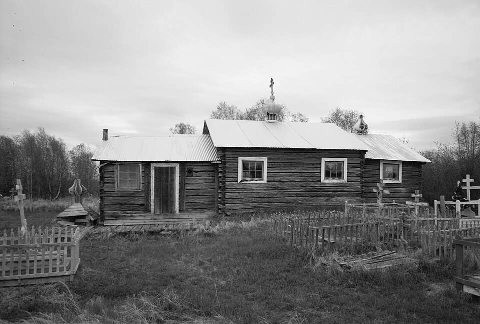
Photograph of St. Seraphim Chapel
Photograph by Jet Lowe, Public domain. Via Wikimedia Commons.

St. Seraphim Chapel

Listed on the National Register of Historic Places in 1980.

From the record

“Seraphim Chapel, also known as the Old Church, is a historic Russian Orthodox church in Lower Kalskag, Alaska, United States, in Bethel Census Area, that may include a portion built in 1843, or it may have all been built later. It was listed on the National Register of Historic Places in 1980.”

Wikipedia article St. Seraphim Chapel, CC BY-SA 4.0.

One of 6 National Register listings published here for Bethel Census Area · listed in 1980 · category: Building.

Sources: the Wikipedia article · the case file at the National Archives · the National Register database, National Park Service

The listing

  • What is counted as historic. The nomination lists 1 building as contributing to the listing.
  • Address. In Lower Kalskag, Lower Kalskag, 99626
  • When was it listed? June 1980
  • Category. building
  • Also known as. Russian Orthodox Church Buildings and Sites TR; Russian Orthodox Church Buildings and Sites TR
  • Census subarea. Aniak census subarea
  • National Register reference number. 80004586 - the number the National Park Service assigned this property when it was listed, and the key its nomination file is catalogued under at the National Archives.

Fires near this property

7 since 2002

Regional context, not property-specific evidence. The federal wildfire occurrence database lists 7 fires within 5 miles of St. Seraphim Chapel between 2002 and 2018, burning about 4,259 acres in total. 1 started naturally. None was recorded as arson. Distance is straight-line from the map coordinates, so a fire counted here may appear on a neighbouring settlement's page as well.

Reported cause Fires
Debris and open burning3
Missing data/not specified/undetermined2
Misuse of fire by a minor1
Natural1

The most recent of them, most recent first, with the day each was reported and the service that recorded it.

DateCause SizeReported by Name on the report
17 August 2005Missing data/not specified/undetermined8.3 acresAlaska Fire ServiceUPPER KALS
10 July 2005Debris and open burning2.0 acresSouthwest Areanot named
16 June 2012Natural121 acresAlaska Fire ServiceROCKY HILL
26 May 2006Debris and open burning16 acresSouthwest Areanot named
20 May 2018Misuse of fire by a minorunder an acreSouthwest AreaKALSKAG MAIN STREET
19 May 2002Debris and open burning4,110 acresAlaska Fire ServiceKALSKAG
15 May 2007Missing data/not specified/undetermined2.0 acresAlaska Fire ServiceALDER

Every fire recorded in Bethel Census Area

Storms near this property

3 since 2009

Regional context, not property-specific evidence. The National Weather Service names Lower Kalskag, the town this property stands in, in 3 storm reports between 2009 and 2024: 3 flood. No death or injury is recorded in these reports. Each account below is quoted exactly as the forecast office filed it, from the NOAA Storm Events Database, and each date opens the federal record of that event.

WhenEvent Place namedHarm What the report says
May 2009FloodLower Kalskag$500,000no account filed
May 2024FloodLower Kalskag-Ice jam flooding had impounded water at a jam located below Kalskag, and the flooding had closed the road connecting Upper and Lower Kalskag impacting transportation in the area. Additional jams were backing up flows along Mud Creek which was impounding water surrounding Kalskag. Mud Creek backup would impact the gas station which had to cut power and close.
May 2018FloodLower Kalskag-As the spring river ice breakup front moved downstream on the Kuskokwim River, an ice jam formed downstream of the villages of Upper Kalskag and Lower Kalskag. The road connecting the two villages was flooded and impassable. Access to the shared power plant was also cut off. Many yards had floodwaters affecting them.

Every storm recorded in Bethel Census Area

Map coverage status

No historic map-sheet match is published for this property yet. That does not mean no map exists. This record needs a coordinate-quality review before it can be joined to a sheet boundary. Browse the county's mapped places while that work is pending.

Sources for this property

National Archives recordThe nomination case file for reference 80004586 in Record Group 79.
Wikipedia articleCommunity-written account of this property, licensed CC BY-SA.
Bethel Census AreaAll 6 listed properties in this county.

Provenance

  • Listing record. National Park Service National Register of Historic Places, listed-properties dataset, current to 2026-05-22.
  • Map join. Address geocoded through the United States Census geocoder, then tested against the published boundary of every sheet in the USGS Historical Topographic Map Collection.
  • How this page is made. Listing fields come from federal records; map-sheet coverage is a labelled coordinate-to-boundary calculation, not a source-field claim.
  • Wildfire. Short, Karen C. 2022. Spatial wildfire occurrence data for the United States, 1992-2020 [FPA_FOD_20221014]. 6th Edition. Fort Collins, CO: Forest Service Research Data Archive. https://doi.org/10.2737/RDS-2013-0009.6 Collected with United States Government funding and usable without additional permissions or fees.
  • Storms. NOAA National Centers for Environmental Information, Storm Events Database https://www.ncei.noaa.gov/stormevents/ A work of the United States government, no copyright under 17 U.S.C. 105. Narratives are quoted verbatim from the National Weather Service report and are not edited or summarised.