
BlockBefore
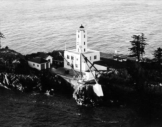
Photograph of Five Finger Islands Light
Photograph by United States Coast Guard, Public domain. Via Wikimedia Commons.

Five Finger Light Station

Built in 1902 (modern architecture). Listed on the National Register of Historic Places in 2004.

From the record

“The Five Finger Islands Light is a lighthouse located on a small island that lies between Stephens Passage and Frederick Sound in southeastern Alaska. It and Sentinel Island Light Station were the first U.S. government lighthouses opened in Alaska, first lit on March 21, 1902.”

Wikipedia article Five Finger Islands Light, CC BY-SA 4.0.

One of 5 National Register listings published here for Petersburg Borough · listed in 2004 · category: District · built in 1902, modern architecture, by United States Lighthouse Service.

Sources: the Wikipedia article · the case file at the National Archives · the National Register database, National Park Service

The listing

  • What is counted as historic. The nomination lists 4 buildingss, 1 structure as contributing to the listing.
  • Still standing. The Park Service records this property as extant.
  • Address. Island of The Five Fingers, approx. 37 mi. NW of the city of Petersburg, Petersburg
  • When was it listed? May 2004
  • Category. district
  • Also known as. Light Stations of the United States MPS
  • Census subarea. Petersburg census subarea
  • When was it built? 1902
  • Architectural style. modern architecture
  • Architect. United States Lighthouse Service
  • National Register reference number. 04000416 - the number the National Park Service assigned this property when it was listed, and the key its nomination file is catalogued under at the National Archives.

Mines and quarries near this property

1 within 5 miles

Regional context, not property-specific evidence. The federal mineral resources record lists 1 working within 5 miles of Five Finger Light Station: 1 prospect. None of them still produces. What was taken out: Gold, Zinc, Copper. Distance is straight-line from the map coordinates, so a quarry counted here may appear on a neighbouring settlement's page as well.

Where SiteCommodity StatusRecorded
The IslanderGold, Zinc, CopperProspect

Storms near this property

1 since 2020

Regional context, not property-specific evidence. The National Weather Service names Petersburg, the town this property stands in, in 1 storm report in 2020: 1 flood. No death or injury is recorded in these reports. Each account below is quoted exactly as the forecast office filed it, from the NOAA Storm Events Database, and each date opens the federal record of that event.

WhenEvent Place namedHarm What the report says
December 2020FloodPetersburg-As the atmospheric river moved over the the central inner channels near Petersburg in the early morning hours of December 1st through the early morning of December 2nd it produced significant amount of precipitation. Through that time frame 3 to 6 of precipitation fell with the highest rain rates of .5 per hour in the morning hours of December 1st with another burst of heavy rainfall in the evening. Falls Creek along Mitkof highway in Petersburg rose quickly from the heavy precipitation along with added runoff from snowmelt at higher elevations. The creek went above minor flood stage in the late morning of December 1st and continued to climb above moderate flood stage of 24 feet in the afternoon. The creek crested at 24.38 feet for a 5 foot rise and produced some impacts to the highway. AKDOT had to close the road at times the night of December 1st due to about 8 to 10 inches of water running over the road along with debris that had to clear off the road.

Every storm recorded in Petersburg Borough

Map coverage status

No historic map-sheet match is published for this property yet. That does not mean no map exists. This record needs a coordinate-quality review before it can be joined to a sheet boundary. Browse the county's mapped places while that work is pending.

Sources for this property

National Archives recordThe nomination case file for reference 04000416 in Record Group 79.
Wikipedia articleCommunity-written account of this property, licensed CC BY-SA.
Petersburg BoroughAll 5 listed properties in this county.

Provenance

  • Listing record. National Park Service National Register of Historic Places, listed-properties dataset, current to 2026-05-22.
  • Map join. Address geocoded through the United States Census geocoder, then tested against the published boundary of every sheet in the USGS Historical Topographic Map Collection.
  • How this page is made. Listing fields come from federal records; map-sheet coverage is a labelled coordinate-to-boundary calculation, not a source-field claim.
  • Mines and quarries. USGS Mineral Resources Data System (MRDS) https://mrdata.usgs.gov/mrds/ A work of the United States government, no copyright under 17 U.S.C. 105.
  • Storms. NOAA National Centers for Environmental Information, Storm Events Database https://www.ncei.noaa.gov/stormevents/ A work of the United States government, no copyright under 17 U.S.C. 105. Narratives are quoted verbatim from the National Weather Service report and are not edited or summarised.