
BlockBefore
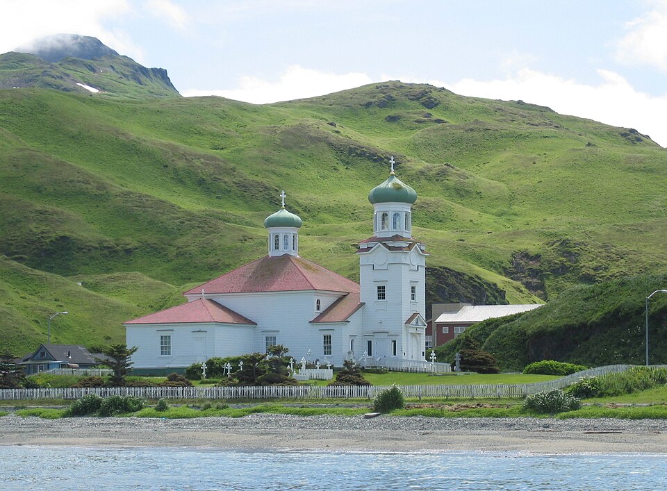
Photograph of Church of the Holy Ascension
Photograph by Brendan Minish (Flickr user bminish) from Castlebar, Ireland, CC BY 2.0. Via Wikimedia Commons.

Church of the Holy Ascension

A National Historic Landmark. Built in 1826. Listed on the National Register of Historic Places in 1970.

From the record

“The Church of the Holy Ascension, also known as the Holy Ascension Orthodox Church, is a prominent landmark in Unalaska, the major community of the western Aleutian Islands in southwestern Alaska. The current church was built in 1894, probably on the site of an 1826 church, and likely using timbers and other elements from the older church.”

Wikipedia article Church of the Holy Ascension, CC BY-SA 4.0.

One of 10 National Register listings published here for Aleutians West Census Area · listed in 1970 · category: Building · built in 1826 · a National Historic Landmark.

Sources: the Wikipedia article · the case file at the National Archives · the National Register database, National Park Service
The listing

  • National Historic Landmark. The highest federal designation, held by about 2,600 places in the country against roughly 100,000 Register listings.
  • What is counted as historic. The nomination lists 2 buildingss as contributing to the listing.
  • Address. In Unalaska, Unalaska, 99685
  • When was it listed? April 1970
  • Category. building
  • Also known as. Russian Orthodox Church Buildings and Sites TR (AD); Russian Orthodox Church Buildings and Sites TR; Russian Orthodox Church Buildings and Sites TR
  • Census subarea. Aleutians West census subarea
  • When was it built? 1826
  • National Register reference number. 70000112 - the number the National Park Service assigned this property when it was listed, and the key its nomination file is catalogued under at the National Archives.

Mines and quarries near this property

7 within 5 miles

Regional context, not property-specific evidence. The federal mineral resources record lists 7 workings within 5 miles of Church of the Holy Ascension: 3 occurrences, 2 past producers, 2 prospects. None of them still produces. What was taken out: Gold, Silver, Gold, Copper, Zinc, Lead, Silver. Distance is straight-line from the map coordinates, so a quarry counted here may appear on a neighbouring settlement's page as well.

Where SiteCommodity StatusRecorded
Misty MountainGold, MercuryOccurrenceArsenopyrite, Gold
Mount CoxcombGold, SilverProspectChalcopyrite, Pyrite
Pyramid Peak, Ruby MineSilver, Gold, Copper, Zinc, LeadPast ProducerChalcopyrite, Gold, Pyrite
Amaknak IslandGoldOccurrenceGold, Pyrite
Amaknak IslandGoldProspect
Pyramid PeakGoldPast Producer
Royal DutchGoldOccurrenceGold

Storms near this property

1 since 2024

Regional context, not property-specific evidence. The National Weather Service names Unalaska, the town this property stands in, in 1 storm report in 2024: 1 heavy rain. No death or injury is recorded in these reports. Each account below is quoted exactly as the forecast office filed it, from the NOAA Storm Events Database, and each date opens the federal record of that event.

WhenEvent Place namedHarm What the report says
March 2024Heavy RainUnalaska-Unalaska Roads Department reported heavy rain in Unalaska washed out several gravel roadways in the surrounding area. Blocked culverts caused additional street flooding and also washed large crevasses up to 4 ft deep in some of the roadways.

Every storm recorded in Aleutians West Census Area

Map coverage status

No historic map-sheet match is published for this property yet. That does not mean no map exists. This record needs a coordinate-quality review before it can be joined to a sheet boundary. Browse the county's mapped places while that work is pending.

Listed places nearby

2 within 8 miles

Other National Register properties close enough to walk or drive between, ordered by distance from this one. Both positions come from the same geocoding pass that matched these properties to their map sheets.

Photograph PropertyDistance Listed
Sitka Spruce Plantation0.8 miles1978
Dutch Harbor Naval Operating Base and Fort Mears, U.S. Army1.5 miles1985

Sources for this property

National Archives recordThe nomination case file for reference 70000112 in Record Group 79.
Wikipedia articleCommunity-written account of this property, licensed CC BY-SA.
Aleutians West Census AreaAll 10 listed properties in this county.

Provenance

  • Listing record. National Park Service National Register of Historic Places, listed-properties dataset, current to 2026-05-22.
  • Map join. Address geocoded through the United States Census geocoder, then tested against the published boundary of every sheet in the USGS Historical Topographic Map Collection.
  • How this page is made. Listing fields come from federal records; map-sheet coverage is a labelled coordinate-to-boundary calculation, not a source-field claim.
  • Mines and quarries. USGS Mineral Resources Data System (MRDS) https://mrdata.usgs.gov/mrds/ A work of the United States government, no copyright under 17 U.S.C. 105.
  • Storms. NOAA National Centers for Environmental Information, Storm Events Database https://www.ncei.noaa.gov/stormevents/ A work of the United States government, no copyright under 17 U.S.C. 105. Narratives are quoted verbatim from the National Weather Service report and are not edited or summarised.