
BlockBefore
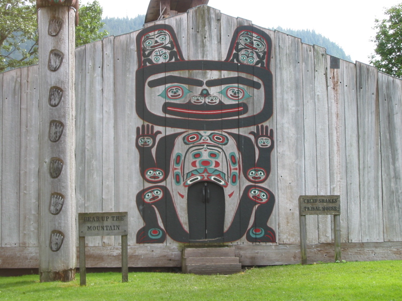
Photograph of Chief Shakes Historic Site
Photograph by James Crippen, CC BY 2.5. Via Wikimedia Commons.

Chief Shakes Historic Site

Listed on the National Register of Historic Places in 1970.

From the record

“The Chief Shakes Historic Site is a historic collection of original and recreated Native Alaskan artifacts. It is located on Shakes Island, inside Wrangell Harbor, Wrangell City and Borough, Alaska.”

Wikipedia article Chief Shakes Historic Site, CC BY-SA 4.0.

One of 4 National Register listings published here for Wrangell City and Borough · listed in 1970 · category: Building.

Sources: the Wikipedia article · the case file at the National Archives · the National Register database, National Park Service
The listing

  • What is counted as historic. The nomination lists 9 objectss, 1 building as contributing to the listing.
  • Still standing. The Park Service records this property as extant.
  • Address. Shakes Island, Wrangell, 99929
  • When was it listed? October 1970
  • Category. building
  • Census subarea. Wrangell census subarea
  • Architect. Civilian Conservation Corps
  • National Register reference number. 70000918 - the number the National Park Service assigned this property when it was listed, and the key its nomination file is catalogued under at the National Archives.

Fires near this property

4 since 1998

Regional context, not property-specific evidence. The federal wildfire occurrence database lists 4 fires within 5 miles of Chief Shakes Historic Site between 1998 and 2004, burning under an acre in total. 3 started naturally. None was recorded as arson. Distance is straight-line from the map coordinates, so a fire counted here may appear on a neighbouring settlement's page as well.

Reported cause Fires
Natural3
Recreation and ceremony1

The most recent of them, most recent first, with the day each was reported and the service that recorded it.

DateCause SizeReported by Name on the report
7 August 1998Recreation and ceremonyunder an acreTongass National ForestDEADMAN
15 August 2004Naturalunder an acreTongass National ForestPATS
15 August 2004Naturalunder an acreTongass National ForestSPUR ROAD
28 June 2000Naturalunder an acreTongass National ForestHIGH

Every fire recorded in Wrangell City and Borough

Mines and quarries near this property

7 within 5 miles

Regional context, not property-specific evidence. The federal mineral resources record lists 7 workings within 5 miles of Chief Shakes Historic Site: 5 past producers, 1 prospect, 1 producer. 1 still produces. What was taken out: Stone, Uranium, Stone, Crushed/Broken. Distance is straight-line from the map coordinates, so a quarry counted here may appear on a neighbouring settlement's page as well.

Where SiteCommodity StatusRecorded
Broome PitStone, Crushed/BrokenPast Producer
Treasure IslandUraniumProspect
Point Highfield QuarryStoneProducer
Rainbow Falls QuarryStonePast Producer
Spur Road PitStonePast Producer
The Cemetery QuarryStonePast Producer
Wrangell Airport QuarryStonePast Producer

Storms near this property

2 since 2011

Regional context, not property-specific evidence. The National Weather Service names Wrangell, the town this property stands in, in 2 storm reports between 2011 and 2023: 1 flood, 1 debris flow. The reports record 6 deaths and 1 injury. Each account below is quoted exactly as the forecast office filed it, from the NOAA Storm Events Database, and each date opens the federal record of that event.

WhenEvent Place namedHarm What the report says
November 2023Debris FlowWrangell6 killed, 1 hurt, $1,600,000By the early evening as the front was moving eastward a landslide was reported near mile post 11 south of Wrangell along the Zimovia Highway, which blocked the road and cut power to residents on the other side of the slide. The landslide resulted in 6 people perishing and 3 homes being destroyed, one person survived as they were saved by search and rescue personnel. The area around the slide was evacuated and homes to the south of the slide were without power for multiple days. Supplies were brought to the cutoff homes via boat. ||Rain amounts around Wrangell were around 3 inches for 24 hours but half of that amount fell within 6 hours preceding the landslide being reported along with high wind gusts at a 900 foot weather station just west of Wrangell on Zarembo Island. There was another large landslide that came down on the next ridge to the east along the Middle Ridge forest service road. This blocked the road and a person had to spend the night in his car as the road was blocked in both directions.
September 2011FloodWrangell$10,000The Stikine River continued to rise for most of a week from high water flowing from swollen streams and rivers in Canada. There was well above normal precipitation that fell over the western portions of British Columbia. Water levels along the Stikine River reached near record levels with significant flood of cabins.

Every storm recorded in Wrangell City and Borough

Map coverage status

No historic map-sheet match is published for this property yet. That does not mean no map exists. This record needs a coordinate-quality review before it can be joined to a sheet boundary. Browse the county's mapped places while that work is pending.

Listed places nearby

1 within 8 miles

Other National Register properties close enough to walk or drive between, ordered by distance from this one. Both positions come from the same geocoding pass that matched these properties to their map sheets.

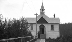
Photograph PropertyDistance Listed
Saint Philip's Episcopal Church0.5 miles1987

Sources for this property

National Archives recordThe nomination case file for reference 70000918 in Record Group 79.
Wikipedia articleCommunity-written account of this property, licensed CC BY-SA.
Wrangell City and BoroughAll 4 listed properties in this county.

Provenance

  • Listing record. National Park Service National Register of Historic Places, listed-properties dataset, current to 2026-05-22.
  • Map join. Address geocoded through the United States Census geocoder, then tested against the published boundary of every sheet in the USGS Historical Topographic Map Collection.
  • How this page is made. Listing fields come from federal records; map-sheet coverage is a labelled coordinate-to-boundary calculation, not a source-field claim.
  • Wildfire. Short, Karen C. 2022. Spatial wildfire occurrence data for the United States, 1992-2020 [FPA_FOD_20221014]. 6th Edition. Fort Collins, CO: Forest Service Research Data Archive. https://doi.org/10.2737/RDS-2013-0009.6 Collected with United States Government funding and usable without additional permissions or fees.
  • Mines and quarries. USGS Mineral Resources Data System (MRDS) https://mrdata.usgs.gov/mrds/ A work of the United States government, no copyright under 17 U.S.C. 105.
  • Storms. NOAA National Centers for Environmental Information, Storm Events Database https://www.ncei.noaa.gov/stormevents/ A work of the United States government, no copyright under 17 U.S.C. 105. Narratives are quoted verbatim from the National Weather Service report and are not edited or summarised.