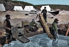
BlockBefore

Jacob Berger House

Listed on the National Register of Historic Places in 1977.

From the record

“The Jacob Berger House, also known locally as the Sally Carrighar House, is a historic Gold Rush mansion at 308 2nd Avenue in Nome, Alaska. It is a two-story late Victorian house, built in 1903-04 by Jacob Berger, a miner who had at least three major finds during the Nome Gold Rush.”

Wikipedia article Jacob Berger House, CC BY-SA 4.0.

One of 15 National Register listings published here for Nome Census Area · listed in 1977 · category: Building.

Sources: the Wikipedia article · the case file at the National Archives · the National Register database, National Park Service
The listing

  • What is counted as historic. The nomination lists 1 building as contributing to the listing.
  • Listed as. Berger, Jacob, House - the National Register files a house under its owner's surname.
  • Address. 1st Ave., Nome, 99762
  • When was it listed? August 1977
  • Category. building
  • Census subarea. Nome census subarea
  • National Register reference number. 77000219 - the number the National Park Service assigned this property when it was listed, and the key its nomination file is catalogued under at the National Archives.

Mines and quarries near this property

10 of 66 shown

Regional context, not property-specific evidence. The federal mineral resources record lists 66 workings within 5 miles of Jacob Berger House: 32 past producers, 16 producers, 9 occurrences, 7 prospects. 17 still produce. What was taken out: Gold, Silver, Tungsten, Sand and Gravel, Construction. Distance is straight-line from the map coordinates, so a quarry counted here may appear on a neighbouring settlement's page as well.

Where SiteCommodity StatusRecorded
Anvil CreekGold, Lead, Silver, TungstenProducerGalena, Gold, Magnetite, Scheelite
Little Creek composite placerGold, Tungsten, SilverPast ProducerArsenopyrite, Gold, Hematite, Ilmenite, Magnetite, Pyrite, Scheelite
NomeIron, PGE, Silver, Tin, GoldOccurrence
Nome Coastal PlainGold, Silver, TungstenProducerArsenopyrite, Gold, Ilmenite, Magnetite, Pyrite, Scheelite
Outer Submarine Beach PlacerGold, CopperProducer1907
Sledge CreekGold, TungstenOccurrencePlacer
Submarine BeachSilver, Gold, Copper, TungstenProducerArsenopyrite, Chalcopyrite, Gold, Ilmenite, Magnetite, Pyrite, Scheelite
Unnamed (near VABM 592, south of Banner Peak)Gold, Antimony, LeadOccurrenceArsenopyrite, Galena, Pyrite, Stibnite
Anvil CreekTungsten, Gold, LeadOccurrencePlacer
Balto CreekTungsten, GoldOccurrencePlacer

Storms near this property

2 since 2009

Regional context, not property-specific evidence. The National Weather Service names Nome, the town this property stands in, in 2 storm reports in 2009: 2 flood. No death or injury is recorded in these reports. Each account below is quoted exactly as the forecast office filed it, from the NOAA Storm Events Database, and each date opens the federal record of that event.

WhenEvent Place namedHarm What the report says
May 2009FloodNome$3,000no account filed
May 2009FloodNome$2,000no account filed

Every storm recorded in Nome Census Area

Map coverage status

No historic map-sheet match is published for this property yet. That does not mean no map exists. This record needs a coordinate-quality review before it can be joined to a sheet boundary. Browse the county's mapped places while that work is pending.

Listed places nearby

5 within 8 miles

Other National Register properties close enough to walk or drive between, ordered by distance from this one. Both positions come from the same geocoding pass that matched these properties to their map sheets.

Photograph PropertyDistance Listed
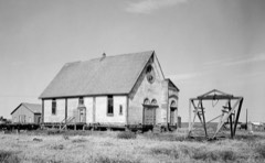
St. Joseph's Catholic Church, Old0.1 miles2000
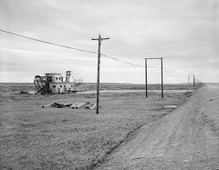
Swanberg Dredge1.6 miles2001
Cape Nome Mining District Discovery Sites3.2 miles1978
Erik Lindblom Placer Claim5.9 miles1976
Snow Creek Placer Claim No. 16.7 miles1976

Sources for this property

National Archives recordThe nomination case file for reference 77000219 in Record Group 79.
Wikipedia articleCommunity-written account of this property, licensed CC BY-SA.
Nome Census AreaAll 15 listed properties in this county.

Provenance

  • Listing record. National Park Service National Register of Historic Places, listed-properties dataset, current to 2026-05-22.
  • Map join. Address geocoded through the United States Census geocoder, then tested against the published boundary of every sheet in the USGS Historical Topographic Map Collection.
  • How this page is made. Listing fields come from federal records; map-sheet coverage is a labelled coordinate-to-boundary calculation, not a source-field claim.
  • Mines and quarries. USGS Mineral Resources Data System (MRDS) https://mrdata.usgs.gov/mrds/ A work of the United States government, no copyright under 17 U.S.C. 105.
  • Storms. NOAA National Centers for Environmental Information, Storm Events Database https://www.ncei.noaa.gov/stormevents/ A work of the United States government, no copyright under 17 U.S.C. 105. Narratives are quoted verbatim from the National Weather Service report and are not edited or summarised.