 Block
Crane Hill, Alabama
12 topographic sheets cover this place, the earliest surveyed in 1956 and the latest in 2000. It stands in the Crane Hill census division. It lies in ZIP code area 35053. It stands on Whetstone Creek. The Survey maps it on the Crane Hill quadrangle. It stands 828 feet above sea level.
On record in Crane Hill
Buildings and businesses the archive holds for this place. Each opens its own page, with the source record it came from.
On the National Register 1 record
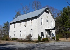 Crane Hill Masonic Lodgelisted 2001
Topographic sheets covering this place
7 surveys from 12 printed sheetsMatched by testing this settlement's coordinate against the published boundary of every sheet in the United States Geological Survey's historical collection. Each opens the scanned sheet at the Survey.
- 1956 USGS Gadsden quadrangle1:250000, 3 printings
- 1958 USGS Gadsden quadrangle1:250000
- 1960 USGS Gadsden quadrangle1:250000, 2 printings
- 1963 USGS Gadsden quadrangle1:250000
- 1969 USGS Crane Hill quadrangle1:24000, 3 printings
- 1980 USGS Haleyville quadrangle1:100000
- 2000 USGS Crane Hill quadrangle1:24000




Fires near this place
106 since 1994Regional context, not property-specific evidence. The federal wildfire occurrence database lists 106 fires within 5 miles of Crane Hill between 1994 and 2020, burning about 745 acres in total. None started naturally. 52 were recorded as arson. Distance is straight-line from the map coordinates, so a fire counted here may appear on a neighbouring settlement's page as well.
| Reported cause | Fires |
|---|---|
| Arson/incendiarism | 52 |
| Debris and open burning | 26 |
| Missing data/not specified/undetermined | 15 |
| Recreation and ceremony | 8 |
| Equipment and vehicle use | 4 |
| Power generation/transmission/distribution | 1 |
The most recent of them, most recent first, with the day each was reported and the service that recorded it.
| Date | Cause | Size | Reported by | Name on the report |
|---|---|---|---|---|
| 8 September 2019 | Arson/incendiarism | 10 acres | Alabama Forestry Commission | 20190908-3 |
| 7 September 2002 | Arson/incendiarism | under an acre | Alabama Forestry Commission | not named |
| 7 September 1998 | Arson/incendiarism | 10 acres | Alabama Forestry Commission | not named |
| 30 September 1998 | Arson/incendiarism | under an acre | Alabama Forestry Commission | not named |
| 3 September 2008 | Arson/incendiarism | 17 acres | Alabama Forestry Commission | 1925 COUNTY ROAD 998, AL |
| 3 September 1999 | Debris and open burning | 3.0 acres | Alabama Forestry Commission | not named |
| 25 September 2007 | Arson/incendiarism | 4.0 acres | Alabama Forestry Commission | not named |
| 23 September 2010 | Arson/incendiarism | 1.0 acres | Alabama Forestry Commission | not named |
Settlements close enough to share some of these fires:
Storms near this place
34 since 1995Regional context, not property-specific evidence. The National Weather Service names Crane Hill in 34 storm reports between 1995 and 2025: 19 thunderstorm wind, 10 hail, 4 tornado, 1 flash flood. The reports record 1 death and 9 injuries. Each account below is quoted exactly as the forecast office filed it, from the NOAA Storm Events Database, and each date opens the federal record of that event.
| When | Event | Place named | Harm | What the report says |
|---|---|---|---|---|
| April 2011 | Tornado (EF4) | Crane Hill | 1 killed | A violent long track tornado developed on the north side of Lewis Smith Lake along County Road 310 where some light damage was found. The tornado tracked northeast snapping numerous large trees and causing significant structural damage to residences along County Roads 222 and 436 near Grandview. The tornado tracked northeast into the city of Cullman. Some of the worst damage occurred just northeast of U.S. Highways 31 and 278. Several small retail buildings were completely destroyed. along with the near total destruction of a large church. The tornado tracked across State Highway 157, then caused additional damage north of State Highway 69 between Simcoe and Pleasant View. Just north of Fairview along County Roads 1559 and 1564, 2 homes were destroyed with significant portions of the homes not found. Further northeast along County Road 1589, the tornado caused major structural damage to several old (early 1900s) homes. Numerous hardwood trees were debarked. A 1/4 to 1/2 mile wide corridor of significant damage persisted between Fairview and the Morgan County line. |
| October 2001 | Thunderstorm Wind | Crane Hill | 9 hurt, $2,000 | Power lines were blown down in Crane Hill. |
| November 2005 | Tornado (F0) | Crane Hill | $35,000 | An F-0 tornado briefly touched down along county road 222 which is just west of county road 940 in Cullman county. Initial damage was to a service station which received moderate roof damage and had its awning partially torn off. Numerous trees were snapped and twisted in this vicinity. There was also damage to a nearby home which had shing damage, a window blown out and a pump house destroyed. Damage to powerlines was also extensive in this area. |
| June 2025 | Thunderstorm Wind | Crane Hill | $20,000 | A tree was knocked down on a mobile home on County Road 940, south of the intersections with County Roads 970 and 818. |
| September 1999 | Thunderstorm Wind | Crane Hill | $15,000 | One mobile home was blown over and several trees and power lines were knocked down near Crane Hill. |
| June 2012 | Thunderstorm Wind | Crane Hill | $10,000 | A few trees were downed by thunderstorm winds across County Road 346. |
| June 2012 | Thunderstorm Wind | Crane Hill | $10,000 | A few power lines were downed by thunderstorm winds near Guthreys Crossing and County Road 222. |
| December 2009 | Thunderstorm Wind | Crane Hill | $10,000 | Trees were blown down on CR 852. |
| November 2003 | Thunderstorm Wind | Crane Hill | $10,000 | Thunderstorm winds completed minor damage to a chicken house. |
| December 2009 | Thunderstorm Wind | Crane Hill | $8,000 | Trees were blown down across CR 985. |
| April 2013 | Thunderstorm Wind | Crane Hill | $5,000 | A tree was downed by thunderstorm winds on County Road 351, about one mile south of Crane Hill, Alabama. |
| February 2000 | Thunderstorm Wind | Crane Hill | $5,000 | Power lines were knocked over in the Crane Hill area. |
| June 1999 | Hail | Crane Hill | $5,000 | Golfball size hail was reported near Cranehill southwest of Cullman. |
| December 2009 | Thunderstorm Wind | Crane Hill | $3,000 | A tree was blown down onto a powerline on county road 864. |
| August 1995 | Thunderstorm Wind | Crane Hill | $3,000 | Emergency management reported several trees down and at least one power line down in Crane Hill in the west central part of Cullman County. |
| March 2024 | Thunderstorm Wind | Crane Hill | $2,000 | Multiple trees were knocked down in the Crane Hill area. Time estimated by radar. |
| February 2001 | Thunderstorm Wind | Crane Hill | $2,000 | Trees were knocked down near the city of Crane Hill. |
| June 2025 | Thunderstorm Wind | Crane Hill | $1,000 | A tree was knocked down at 14884 CR 222. Time estimated by radar. |
| June 2019 | Thunderstorm Wind | Crane Hill | $200 | A tree was knocked down. |
| April 2019 | Thunderstorm Wind | Crane Hill | - | Large trees were uprooted and some shingles were blown off at this location. Minor damage to the home was reported. |
| June 2019 | Thunderstorm Wind | Crane Hill | - | Trees were knocked down. |
| June 2019 | Thunderstorm Wind | Crane Hill | - | Power poles, lines and trees were knocked down onto CR 852. |
| November 2016 | Tornado (EF1) | Crane Hill | - | This tornado was originally the Arley/Helicon EF-2 tornado that originated in Winston County. It continued across County Road 986, causing significant damage to a barn and snapping several hardwood and softwood trees. The tornado continued northeast, continued to snap trees and destroyed another shed as it crossed CR 946 and 939. It appeared to lift northeast of CR 939. |
| March 2011 | Hail | Crane Hill | - | One inch diameter hail was reported. |
| July 2011 | Hail | Crane Hill | - | Nickel sized hail was reported. |
| September 2011 | Flash Flood | Crane Hill | - | Flash flooding occurred due to the very heavy rainfall that moved across the area associated with the remnants of Tropical Storm Lee. The Crane Hill park was several inches under water due to the flash flooding that occurred. |
| April 2009 | Hail | Crane Hill | - | Nickel sized hail fell approximately 3 miles east of Crane Hill. |
| April 2008 | Hail | Crane Hill | - | A severe thunderstorm produced quarter size hail in the Crane Hill community. |
| March 2007 | Tornado (EF1) | Crane Hill | - | Representatives from the National Weather Service in Birmingham conducted an aerial survey in Winston and Cullman Counties relating to storm damage reported during the March 1, 2007 tornado outbreak. It was determined that this damage was caused by an EF-2 tornado on the Enhanced Fujita scale with maximum estimated winds of 110-115 mph. The damage track extended 9.1 miles and was a maximum of 100 yards wide, but most of this occurred in Winston County.|The track extended less than 3/4 of a mile into extreme western Cullman County, north of County Road 141 and south of the Nesmith community. By the time the tornado reached Cullman County, it had weakened to a low-end EF-1 tornado, with estimated winds of 75 mph and a path width of 25 to 50 yards. The tornado was responsible only for tree damage within Cullman County before lifting around 3:57 pm CST.| |
| May 2005 | Hail | Crane Hill | - | Nickel size hail was reported. |
| November 2005 | Hail | Crane Hill | - | Penny size hail was reported. |
| November 2002 | Hail | Crane Hill | - | Dime size hail was reported across western Cullman County. |
| June 2001 | Hail | Crane Hill | - | Dime size hail was reported in Crane Hill. |
| March 2000 | Hail | Crane Hill | - | Dime size hail was reported near Crane Hill. |
Nearest settlements
The eight closest, with where each one stands in the county. Distances are straight-line, computed from the Geographic Names Information System coordinates.
| Map | Place | Distance | Sheets |
|---|---|---|---|
| Trade | 2.4 miles | 12 | |
| Mount Zion | 2.6 miles | 12 | |
| Sulphur Springs | 2.6 miles | 12 | |
| Guthery Crossroads | 3.1 miles | 12 | |
| Logan | 4.3 miles | 11 | |
| Brushy Pond | 5.4 miles | 12 | |
| Chances Crossroad | 5.5 miles | 11 | |
| Trimble | 6.1 miles | 18 |
Elsewhere
Matched on this settlement's Geographic Names Information System number rather than its name, so it cannot be a different place of the same name in another state.
| Wikipedia article on Crane Hill | An encyclopaedic summary. Its text is share-alike, so it is linked here rather than copied. |
| Wikidata item Q4272236 | The structured record the population and elevation above come from. Public domain (CC0). |
Provenance
This settlement is recorded in the Geographic Names Information System as feature 151747. The sheet list is computed by point-in-boundary test against the United States Geological Survey's historical topographic inventory. Both are works of the United States government and carry no copyright under 17 U.S.C. 105.
Wildfire. Short, Karen C. 2022. Spatial wildfire occurrence data for the United States, 1992-2020 [FPA_FOD_20221014]. 6th Edition. Fort Collins, CO: Forest Service Research Data Archive. https://doi.org/10.2737/RDS-2013-0009.6 Collected with United States Government funding and usable without additional permissions or fees.
Storms. NOAA National Centers for Environmental Information, Storm Events Database https://www.ncei.noaa.gov/stormevents/ A work of the United States government, no copyright under 17 U.S.C. 105. Narratives are quoted verbatim from the National Weather Service report and are not edited or summarised.