 Block
From the record
One of 14 National Register listings published here for St. Clair County · listed in 2001 · category: District.
Sources: the case file at the National Archives · the National Register database, National Park Service
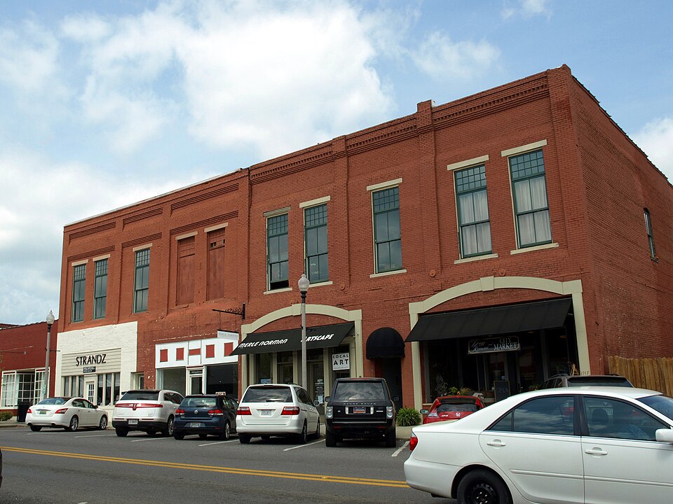
Listed on the National Register of Historic Places in 2001.
One of 14 National Register listings published here for St. Clair County · listed in 2001 · category: District.
Sources: the case file at the National Archives · the National Register database, National Park Service
Regional context, not property-specific evidence. The federal wildfire occurrence database lists 124 fires within 5 miles of Pell City Downtown Historic District between 1994 and 2020, burning about 1,248 acres in total. 2 started naturally. 38 were recorded as arson. Distance is straight-line from the map coordinates, so a fire counted here may appear on a neighbouring settlement's page as well.
| Reported cause | Fires |
|---|---|
| Debris and open burning | 59 |
| Arson/incendiarism | 38 |
| Missing data/not specified/undetermined | 8 |
| Recreation and ceremony | 6 |
| Smoking | 5 |
| Misuse of fire by a minor | 4 |
| Equipment and vehicle use | 2 |
| Natural | 2 |
The most recent of them, most recent first, with the day each was reported and the service that recorded it.
| Date | Cause | Size | Reported by | Name on the report |
|---|---|---|---|---|
| 9 September 1998 | Debris and open burning | 5.0 acres | Alabama Forestry Commission | not named |
| 9 September 1998 | Arson/incendiarism | 10 acres | Alabama Forestry Commission | not named |
| 6 September 1995 | Debris and open burning | 2.0 acres | Alabama Forestry Commission | not named |
| 4 September 1995 | Misuse of fire by a minor | 3.0 acres | Alabama Forestry Commission | not named |
| 3 September 1998 | Debris and open burning | 2.0 acres | Alabama Forestry Commission | not named |
| 29 September 2007 | Arson/incendiarism | 8.0 acres | Alabama Forestry Commission | not named |
| 28 September 2000 | Debris and open burning | 5.0 acres | Alabama Forestry Commission | not named |
| 20 September 2019 | Arson/incendiarism | 5.0 acres | Alabama Forestry Commission | 20190920-17 |
Regional context, not property-specific evidence. The federal mineral resources record lists 7 workings within 5 miles of Pell City Downtown Historic District: 6 unknowns, 1 producer. 1 still produces. What was taken out: Iron, Clay. Distance is straight-line from the map coordinates, so a quarry counted here may appear on a neighbouring settlement's page as well.
Regional context, not property-specific evidence. The National Weather Service names Pell City, the town this property stands in, in 38 storm reports between 1995 and 2025: 24 thunderstorm wind, 9 hail, 2 tornado, 2 funnel cloud. The reports record 1 death and 2 injuries. Each account below is quoted exactly as the forecast office filed it, from the NOAA Storm Events Database, and each date opens the federal record of that event.
| When | Event | Place named | Harm | What the report says |
|---|---|---|---|---|
| April 2011 | Thunderstorm Wind | Pell City | 1 killed | Storm damage in and around the cities of Pell City and Riverside was found to be consistent with straight-line winds, with peak wind gusts estimated between 80 and 100 mph. There was a diffuse and intermittent, yet discernible, swath of wind damage that extended from just west of the St. Clair County Courthouse, northeastward across Pell City, Industrial Park Drive, Interstate 20, and through Riverside. Additional isolated wind damage was noted to the south and east of this main damage swath. The most significant damage across the area were several large trees that were uprooted, causing damage to homes and structures. One fatality was caused when a large oak tree was uprooted and fell on a manufactured home. Two metal buildings received direct damage from the winds; the damage on both of these buildings appears to have been associated with the failure of large doors. Dozens of homes in the area received minor roof damage as well. |
| November 2001 | Tornado (F2) | Pell City | 2 hurt, $500,000 | A tornado rated an F2 began weakly on the west-southwest side of Pell City just behind the school at 3:10 pm. The tornado traveled on an east-northeast path downing a communication tower at the EMA/911 office and doing minor roof damage. The storm then crossed over downtown Pell City where a number of buildings sustained light to moderate roof damage along with awnings damaged and some windows broken. The tornado crossed US 231 and became very weak, possibly lifting for a little more than a mile, before slamming into a number of buildings in an industrial park. Some of the greatest destruction was done here. The tornado crossed Interstate 20 and ended after damaging a couple of houses on Sprayberry Road at approximately 3:17 pm.The tornado path was 4.5 miles long and approximately 100 yards wide at the widest. No deaths occurred in this tornado but there were two injuries, both classified as minor.Beginning: 33 34.926/86 17.647 Ending: 33 37.039/86 14.029 |
| May 2003 | Tornado (F1) | Pell City | $85,000 | This was the first of two tornadoes to touch down in St. Clair County. It began at the intersection of SR174 and Cook Springs Road northwest of Pell City. The tornado traveled southeasterly through the Bowman Circle and Stewarts areas crossing Mineral Springs Road and lifting just before reaching Interstate 20 (between exits 156 and 158). The tornado downed many trees and power lines and also damaged a few buildings in the area. At least one mobile home was destroyed.Beg: 33 38.519/86 21.652 End: 33 36.308/86 17.702 |
| June 2007 | Thunderstorm Wind | Pell City | $50,000 | Scattered tree damage was reported all around Pell City, at least one of which fell onto a house. The roof of a junior high school, and a nearby city services building, both received damage. The batting cage at a high school ball field was blown into a fence, damaging about 100 feet of the fence. Several storage sheds in a home improvement store were blown down an embankment and heavily damaged. |
| May 2003 | Thunderstorm Wind | Pell City | $28,000 | Thunderstorm wind cut a swath of damage from a rural area across some homes in the eastern section of St. Clair County just north of Riverside. Several homes sustained minor damage on Lock 4 Road. |
| February 2000 | Thunderstorm Wind | Pell City | $20,000 | Trees were knocked down along SR 31. One of the downed trees fell onto a house. |
| July 2004 | Thunderstorm Wind | Pell City | $15,000 | Several trees and power lines were blown down in the Pine Harbor area. One of the trees landed on a building at the Pine Harbor Country Club. |
| June 1996 | Thunderstorm Wind | Pell City | $15,000 | no account filed |
| April 2001 | Hail | Pell City | $8,000 | One and one half inch diameter size hail was reported in Pell City. |
| April 1996 | Hail | Pell City | $8,000 | no account filed |
| May 2003 | Thunderstorm Wind | Pell City | $6,000 | Several trees were knocked down in extreme southern St. Clair County. |
| June 1997 | Thunderstorm Wind | Pell City | $6,000 | Large limbs and a few trees were down in Pell City and Moody, in the southern part of the county. |
| May 2003 | Thunderstorm Wind | Pell City | $5,000 | Trees were blown down along SR 174 in Pell City. |
| May 2001 | Thunderstorm Wind | Pell City | $5,000 | Trees and power lines were blown down just north of Pell City. |
| January 1997 | Hail | Pell City | $5,000 | no account filed |
| July 1995 | Thunderstorm Wind | Pell City | $4,000 | Several trees were reported down in the Chula Vista area about five miles west of Pell City. |
| June 2011 | Thunderstorm Wind | Pell City | $3,000 | Numerous trees were blown down around Pell City. |
| July 1995 | Thunderstorm Wind | Pell City | $3,000 | Trees were reported down in the area about five miles north of Pell City. |
| February 2011 | Thunderstorm Wind | Pell City | $2,000 | Several trees blown down in and around Pell City. |
| April 2006 | Thunderstorm Wind | Pell City | $2,000 | Trees down in Argo, New London, and Wattsville. |
| July 2004 | Thunderstorm Wind | Pell City | $2,000 | A few trees were knocked down in Pell City. |
| February 2025 | Thunderstorm Wind | Pell City | - | Trees were downed in the Pell City area. |
| April 2025 | Thunderstorm Wind | Pell City | - | Numerous trees were downed across Pell City. |
| May 2024 | Thunderstorm Wind | Pell City | - | Several trees were downed around Pell City and along I-20 near Leeds. Along Highway 231 south of Pell City, a storage building at a business had metal torn off and wrapped around power lines. |
| June 2023 | Thunderstorm Wind | Pell City | - | Several trees uprooted across roadways in Pell City. |
| June 2023 | Hail | Pell City | - | Quarter size hail reported in Pell City. |
| July 2022 | Thunderstorm Wind | Pell City | - | Several trees uprooted in Pell City. |
| June 2020 | Hail | Pell City | - | Large hail reported in Pell City. |
| March 2013 | Thunderstorm Wind | Pell City | - | Duran Junior High School sustained rood damage, as well as the Press Box at the football field. Additionally, an airport hanger door was blown in and damaged an airplane at the St. Clair County Airport. |
| July 2012 | Thunderstorm Wind | Pell City | - | Trees were reported down within the city limits of Pell City. |
| September 2006 | Funnel Cloud | Pell City | - | Police reported a funnel cloud looking south from the intersection of Al-174 and US-231, toward Pell City. |
| July 2004 | Hail | Pell City | - | Nickel size hail was reported in the Pell City area. |
| March 1995 | Hail | Pell City | - | Hail slightly smaller than a quarter was reported in Pell City. |
| April 1995 | Thunderstorm Wind | Pell City | - | Numerous large tree limbs were reported down in Pell City. |
| April 2008 | Hail | Pell City | - | no account filed |
| April 2006 | Hail | Pell City | - | no account filed |
| April 2006 | Funnel Cloud | Pell City | - | no account filed |
| January 1996 | Heavy Rain | Pell City | - | no account filed |
No historic map-sheet match is published for this property yet. That does not mean no map exists. This record needs a coordinate-quality review before it can be joined to a sheet boundary. Browse the county's mapped places while that work is pending.
Other National Register properties close enough to walk or drive between, ordered by distance from this one. Both positions come from the same geocoding pass that matched these properties to their map sheets.
| Photograph | Property | Distance | Listed |
|---|---|---|---|
 | Avandale Mill Historic District | 0.5 miles | 2000 |
| National Archives record | The nomination case file for reference 01001169 in Record Group 79. |
| St. Clair County | All 14 listed properties in this county. |