 Block
From the record
One of 47 National Register listings published here for Tuscaloosa County · listed in 2002 · category: Building · built in 1845.
Sources: the case file at the National Archives · the National Register database, National Park Service
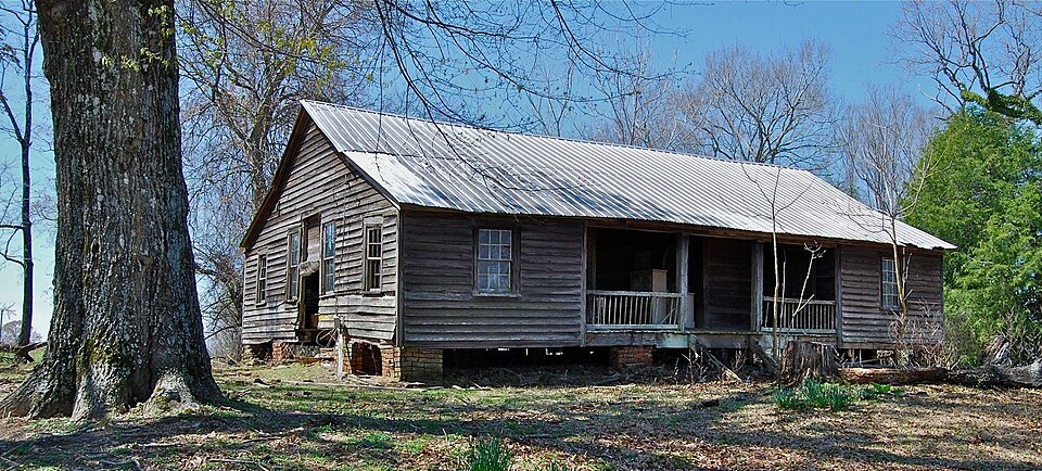
Built in 1845. Listed on the National Register of Historic Places in 2002.
One of 47 National Register listings published here for Tuscaloosa County · listed in 2002 · category: Building · built in 1845.
Sources: the case file at the National Archives · the National Register database, National Park Service
Regional context, not property-specific evidence. The federal wildfire occurrence database lists 70 fires within 5 miles of Samuel Johnson House between 1994 and 2019, burning about 411 acres in total. 1 started naturally. 18 were recorded as arson. Distance is straight-line from the map coordinates, so a fire counted here may appear on a neighbouring settlement's page as well.
| Reported cause | Fires |
|---|---|
| Debris and open burning | 21 |
| Arson/incendiarism | 18 |
| Missing data/not specified/undetermined | 9 |
| Equipment and vehicle use | 7 |
| Recreation and ceremony | 5 |
| Railroad operations and maintenance | 3 |
| Smoking | 2 |
| Misuse of fire by a minor | 2 |
| Power generation/transmission/distribution | 2 |
| Natural | 1 |
The most recent of them, most recent first, with the day each was reported and the service that recorded it.
| Date | Cause | Size | Reported by | Name on the report |
|---|---|---|---|---|
| 5 September 1995 | Recreation and ceremony | 1.0 acres | Alabama Forestry Commission | not named |
| 5 September 1995 | Recreation and ceremony | 2.0 acres | Alabama Forestry Commission | not named |
| 25 September 2000 | Arson/incendiarism | under an acre | Alabama Forestry Commission | not named |
| 23 September 1999 | Debris and open burning | 1.0 acres | Alabama Forestry Commission | not named |
| 21 September 1997 | Recreation and ceremony | 1.0 acres | Alabama Forestry Commission | not named |
| 19 September 2013 | Missing data/not specified/undetermined | 1.0 acres | Alabama Forestry Commission | NWR-20130919-002 |
| 15 September 2013 | Missing data/not specified/undetermined | 4.0 acres | Alabama Forestry Commission | NWR-20130915-001 |
| 22 August 2008 | Debris and open burning | 3.8 acres | Alabama Forestry Commission | COUNTY ROAD 19, AL |
Regional context, not property-specific evidence. The National Weather Service names Buhl, the town this property stands in, in 15 storm reports between 1999 and 2020: 6 thunderstorm wind, 5 hail, 4 tornado. The reports record 2 injuries. Each account below is quoted exactly as the forecast office filed it, from the NOAA Storm Events Database, and each date opens the federal record of that event.
| When | Event | Place named | Harm | What the report says |
|---|---|---|---|---|
| September 2005 | Tornado (F1) | Buhl | 2 hurt, $250,000 | no account filed |
| September 2005 | Tornado (F1) | Buhl | $200,000 | The third tornado to affect the Buhl community in one afternoon touched down at approximately 559 PM CDT. The tornado started just east of Sipsey Valley Road and moved due north. The tornado damaged several homes near Sipsey Valley Road and Sipsey Lane. The tornado moved over rural countryside and then entered Buhl. The Volunteer Fire Department and several other buildings sustained minor roof damage. The tornado then turned to the left and crossed County Road 140 and US Highway 82. The tornado moved along the Sipsey River north of US 82 and lifted around 606 PM CDT. Numerous trees and several power lines were snapped off or were uprooted along the path. This tornado was occurred from the same parent thunderstorm that produced the tornado down the street on Sipsey Valley Road. The tornado damage path was 4.8 miles long and 125 yards wide at its widest point. This tornado was produced by the remnants of Hurricane Rita. Begin: 33 13.19/8745.60 End: 33 17.29/87 45.40 |
| September 2005 | Tornado (F0) | Buhl | $60,000 | A tornado touched down at approximately 552 PM CDT along Sipsey Valley Road between Buhl and Romulus. The tornado damaged three homes and snapped off several trees near Sipsey Valley Road. The tornado lifted in the rural countryside east of Sipsey Valley Road around 553 PM CDT. The tornado damage path was 1.2 miles long and 60 yards wide at its widest point. This tornado was produced by the remnants of Hurricane Rita.Begin: 33 10.19/87 46.49 End: 33 11.09/8745.79 |
| September 2005 | Tornado (F0) | Buhl | $20,000 | no account filed |
| May 2003 | Hail | Buhl | $15,000 | Penny to half dollar size hail was reported near Buhl, Romulus, Tuscaloosa, Abernant, Tuscaloosa Airport, and Northport. |
| December 2009 | Thunderstorm Wind | Buhl | $2,000 | Trees and power lines were blown down on Sipsey Valley Road. |
| September 2009 | Thunderstorm Wind | Buhl | $2,000 | Several trees were blown down in the Buhl community. |
| April 2009 | Thunderstorm Wind | Buhl | $500 | A tree was blown down on Sipsey Valley Road, just north of Kellyton Road. |
| August 2020 | Thunderstorm Wind | Buhl | - | Several trees uprooted in the town of Buhl. |
| October 2014 | Thunderstorm Wind | Buhl | - | Power lines down near the intersection of Sipsey Valley Road and Cornelius Church Road. |
| April 2014 | Thunderstorm Wind | Buhl | - | In the Buhl and Elrod communities, numerous trees and powerlines were blown down along U.S. Highway 82 and County Road 140. In addition, several buildings in the surrounding area, including a church and at least two manufactured homes, sustained minor damage. One manufactured home sustained heavy damage from a fallen tree. |
| May 1999 | Hail | Buhl | - | Dime size hail was reported in Buhl. |
| September 2009 | Hail | Buhl | - | no account filed |
| April 2009 | Hail | Buhl | - | no account filed |
| March 2007 | Hail | Buhl | - | no account filed |
No historic map-sheet match is published for this property yet. That does not mean no map exists. This record needs a coordinate-quality review before it can be joined to a sheet boundary. Browse the county's mapped places while that work is pending.
| National Archives record | The nomination case file for reference 02001069 in Record Group 79. |
| Tuscaloosa County | All 47 listed properties in this county. |