 Block
From the record
One of 13 National Register listings published here for Shelby County · listed in 2006 · category: District.
Sources: the case file at the National Archives · the National Register database, National Park Service
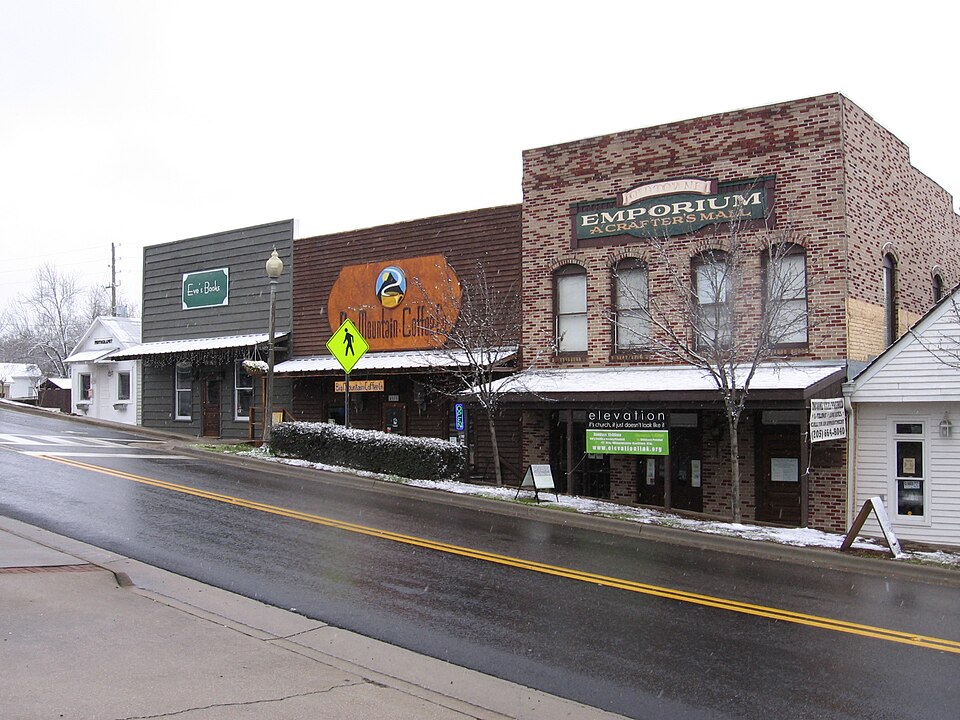
Listed on the National Register of Historic Places in 2006.
One of 13 National Register listings published here for Shelby County · listed in 2006 · category: District.
Sources: the case file at the National Archives · the National Register database, National Park Service
Regional context, not property-specific evidence. The federal wildfire occurrence database lists 94 fires within 5 miles of Helena Historic District between 1994 and 2019, burning about 750 acres in total. 1 started naturally. 26 were recorded as arson. Distance is straight-line from the map coordinates, so a fire counted here may appear on a neighbouring settlement's page as well.
| Reported cause | Fires |
|---|---|
| Debris and open burning | 35 |
| Arson/incendiarism | 26 |
| Missing data/not specified/undetermined | 10 |
| Railroad operations and maintenance | 10 |
| Recreation and ceremony | 5 |
| Equipment and vehicle use | 3 |
| Misuse of fire by a minor | 2 |
| Natural | 1 |
| Smoking | 1 |
| Power generation/transmission/distribution | 1 |
The most recent of them, most recent first, with the day each was reported and the service that recorded it.
| Date | Cause | Size | Reported by | Name on the report |
|---|---|---|---|---|
| 6 September 1995 | Debris and open burning | 1.0 acres | Alabama Forestry Commission | not named |
| 24 September 1999 | Arson/incendiarism | under an acre | Alabama Forestry Commission | not named |
| 20 September 1999 | Arson/incendiarism | 3.0 acres | Alabama Forestry Commission | not named |
| 19 September 2000 | Arson/incendiarism | 3.0 acres | Alabama Forestry Commission | not named |
| 17 September 1998 | Debris and open burning | 1.0 acres | Alabama Forestry Commission | not named |
| 11 September 2002 | Smoking | under an acre | Alabama Forestry Commission | not named |
| 10 September 1995 | Debris and open burning | 10 acres | Alabama Forestry Commission | not named |
| 3 August 1999 | Railroad operations and maintenance | under an acre | Alabama Forestry Commission | not named |
Regional context, not property-specific evidence. The federal mineral resources record lists 13 workings within 5 miles of Helena Historic District: 6 producers, 3 past producers, 3 unknowns, 1 prospect. 6 still produce. What was taken out: Iron, Stone, Crushed/Broken, Calcium, Clay. Distance is straight-line from the map coordinates, so a quarry counted here may appear on a neighbouring settlement's page as well.
| Where | Site | Commodity | Status | Recorded |
|---|---|---|---|---|
| Parkwood | Bloating Material | Producer | Sedimentary | |
| Alabaster Lime Plant | Calcium | Past Producer | ||
| Jef 6 Clay Prospect | Clay | Prospect | ||
| Landmark Quarry & Lime Mill | Calcium | Producer | ||
| Parkwood Mine | Clay | Producer | ||
| Helena Quarry | Stone, Crushed/Broken | Producer | ||
| Lacon Plant No. 3 Pit | Stone, Crushed/Broken | Producer | ||
| Scotrock Quarry | Stone, Crushed/Broken | Producer | ||
| Helena, Ne Of | Iron | Past Producer | Residual | |
| Siluria, W Of | Iron | Past Producer | Residual |
Regional context, not property-specific evidence. The National Weather Service names Helena, the town this property stands in, in 31 storm reports between 1995 and 2025: 15 thunderstorm wind, 10 hail, 3 lightning, 2 flash flood. The reports record 1 injury. Each account below is quoted exactly as the forecast office filed it, from the NOAA Storm Events Database, and each date opens the federal record of that event.
| When | Event | Place named | Harm | What the report says |
|---|---|---|---|---|
| June 1998 | Lightning | Helena | 1 hurt | A man was struck by lightning while standing in a church parking lot, across from the Helena post office. He was taken to the Shelby County Medical Center and was in good condition. |
| April 2005 | Tornado (F1) | Helena | $400,000 | National Weather Service meteorologists surveyed the damage that affected the Helena, Alabaster, Pelham, and Chelsea areas early Saturday morning. The tornado has been rated an F1 with winds estimated around 75 miles an hour. The tornado first touched down just west of County Road 93 near the Cahaba Wildlife Management Area in Helena. The tornado moved generally eastward and crossed County Road 17, County Road 58, US 31, Interstate 65 and County Road 11 before ending near County Road 39. The tornado damage path was approximately 11.6 miles long and 100 yards wide at its widest point. The tornado was on the ground from approximately 504 AM CDT to 518 AM CDT. The initial damage was minor with only a few trees uprooted or snapped off west of County Road 17 in Helena. As the tornado crossed County Road 17, it intensified and caused its most significant damage. The most concentrated and significant damage occurred near Scurlock Road and County Road 17 then eastward along County Road 58 to just past County Road 95. Several subdivisions were affected including Braelinn Village, Amberley Woods, Navajo Hills, and Port South. Numerous homes suffered shingle and minor roof damage along with a few broken windows. Many trees and power lines were either blown down or snapped off. Power was unavailable for several hours due to downed power poles. A few homes suffered major damage due to fallen trees. Several automobiles and outbuildings were destroyed. A municipal park in Helena sustained minor damage. As the tornado crossed US 31 near Walmart, several large trees and signs were blown down or snapped off. A few homes just east of US 31 were damaged from fallen trees. For the remainder of the tornadoes path, the damage was relatively minor and mainly affected trees. The tornado crossed the Weatherly subdivision and the Ballantrae Golf Course and subdivision before ending just east of County Road 39 near Hidden Ridge. Begin: 33 16.08/86 53.41 End: 33 16.45/86 41.34 |
| March 2002 | Hail | Helena | $400,000 | no account filed |
| June 2006 | Lightning | Helena | $100,000 | no account filed |
| June 2006 | Lightning | Helena | $50,000 | no account filed |
| September 2009 | Flash Flood | Helena | $25,000 | Water was flowing over the road at the intersection of CR-52 and CR-17 in Helena. At least a dozen vehicles became trapped and roads had to be closed at Joe Tucker Park, due to flood waters flowing over the spillway there. |
| June 2003 | Thunderstorm Wind | Helena | $5,000 | What was believed to be a small downburst struck the southern side of Helena. The path of minor damage stretched for approximately nine tenths of a mile. Initial damage was very narrow but seemed to widen to about a tenth of a mile at the end of the path. The initial damage occurred to a house roof where a patch of shingles covering about 12 square feet was removed. The wind then removed a roof to a dumpster enclosure and a nearby metal awning at the Winn Dixie. From there to the end of the path damage was in the form of downed trees and some power/telephone lines. Some trees were broken off and a few were uprooted. Radar data showed the development of a small shower that was overtaken by a line of thunderstorms at the approximate time of the event. |
| May 2001 | Thunderstorm Wind | Helena | $5,000 | no account filed |
| April 2011 | Thunderstorm Wind | Helena | $2,000 | Trees were blown down on Highway 261. |
| June 2011 | Thunderstorm Wind | Helena | $1,000 | A few trees were blown down in Helena. |
| March 2025 | Thunderstorm Wind | Helena | - | Powerlines were downed on Helena Rd. |
| February 2025 | Thunderstorm Wind | Helena | - | A tree was blown onto a house on St. Charles Drive in Helena. |
| June 2022 | Thunderstorm Wind | Helena | - | Several trees uprooted in Helena. |
| June 2016 | Thunderstorm Wind | Helena | - | Several trees uprooted near the intersection of Highway 52 and Brook Drive. |
| March 2016 | Thunderstorm Wind | Helena | - | Several trees uprooted near Helena City Hall. |
| July 2015 | Thunderstorm Wind | Helena | - | Several trees uprooted near Highway 17 and Fieldstone Drive in the city of Helena. |
| May 2015 | Thunderstorm Wind | Helena | - | Several trees uprooted along Highway 17. |
| July 2012 | Thunderstorm Wind | Helena | - | A tree was blown down, blocking Highway 13. |
| April 2011 | Hail | Helena | - | Quarter size hail was observed in Rock Ridge at the junction of Highway 17 and Highway 58. |
| February 2008 | Hail | Helena | - | Reported just off CR-52, in the Brandywine Subdivision. |
| August 2006 | Flash Flood | Helena | - | Several roadways in residential neighborhoods were flooded and temporarily impassable. |
| March 2003 | Hail | Helena | - | Penny size hail was reported in Helena. |
| November 2001 | Hail | Helena | - | Dime size hail was reported in the Helena and Pelham area. A rotating wall cloud was reported near Interstate 65 and CR 52. |
| April 2000 | Hail | Helena | - | Penny size hail was reported in Helena. |
| June 1999 | Thunderstorm Wind | Helena | - | A few large trees were blown over and blocking the road in the Dearing Downs Subdivision. |
| July 1999 | Thunderstorm Wind | Helena | - | A few trees were reported down in the Dearing Downs Subdivision in Helena. |
| June 1995 | Hail | Helena | - | Hail from one-half to three-quarters of an inch fell at Helena and Alabaster in west-central Shelby County. Nickel-size hail fell at Siluria immediately east of Alabaster. Four large trees up to two feet in diameter were downed in the Scottsdale Subdivision of Alabaster. Wind gusted to 54 mph at the National Weather Service Forecast Office at the Shelby County airport on the south side of Alabaster. |
| March 1995 | Thunderstorm Wind | Helena | - | An amateur radio storm spotters reported a wind gust to 50 knots with a thunderstorm. No damage was reported. |
| April 2011 | Hail | Helena | - | no account filed |
| April 2006 | Hail | Helena | - | no account filed |
| May 2001 | Hail | Helena | - | no account filed |
No historic map-sheet match is published for this property yet. That does not mean no map exists. This record needs a coordinate-quality review before it can be joined to a sheet boundary. Browse the county's mapped places while that work is pending.
| National Archives record | The nomination case file for reference 06000278 in Record Group 79. |
| Shelby County | All 13 listed properties in this county. |