 Block
From the record
One of 29 National Register listings published here for Colbert County · listed in 2019 · category: Building.
Sources: the National Register database, National Park Service
Listed on the National Register of Historic Places in 2019.
One of 29 National Register listings published here for Colbert County · listed in 2019 · category: Building.
Sources: the National Register database, National Park Service
Regional context, not property-specific evidence. The federal wildfire occurrence database lists 93 fires within 5 miles of Easterwood House between 1993 and 2019, burning about 564 acres in total. 3 started naturally. 30 were recorded as arson. Distance is straight-line from the map coordinates, so a fire counted here may appear on a neighbouring settlement's page as well.
| Reported cause | Fires |
|---|---|
| Arson/incendiarism | 30 |
| Debris and open burning | 30 |
| Missing data/not specified/undetermined | 15 |
| Equipment and vehicle use | 7 |
| Recreation and ceremony | 5 |
| Natural | 3 |
| Fireworks | 1 |
| Railroad operations and maintenance | 1 |
| Other causes | 1 |
The most recent of them, most recent first, with the day each was reported and the service that recorded it.
| Date | Cause | Size | Reported by | Name on the report |
|---|---|---|---|---|
| 9 September 2002 | Arson/incendiarism | 35 acres | Alabama Forestry Commission | not named |
| 7 September 1993 | Fireworks | 1.0 acres | Natchez Trace Parkway | ROCKET |
| 3 September 2011 | Debris and open burning | 3.0 acres | Alabama Forestry Commission | 201 PLANTVIEW RD, AL |
| 29 September 2017 | Equipment and vehicle use | 5.3 acres | Natchez Trace Parkway | CHUCKWAGON COMPLEX |
| 23 September 2019 | Equipment and vehicle use | under an acre | Natchez Trace Parkway | MP 318 |
| 21 September 2010 | Natural | 3.5 acres | Natchez Trace Parkway | CHEROKEE1 |
| 21 September 2001 | Missing data/not specified/undetermined | 2.0 acres | Alabama Forestry Commission | not named |
| 19 September 2007 | Debris and open burning | under an acre | Alabama Forestry Commission | not named |
Regional context, not property-specific evidence. The federal mineral resources record lists 1 working within 5 miles of Easterwood House: 1 producer. All of them still produce. What was taken out: Stone, Crushed/Broken. Distance is straight-line from the map coordinates, so a quarry counted here may appear on a neighbouring settlement's page as well.
| Where | Site | Commodity | Status | Recorded |
|---|---|---|---|---|
| Cherokee Quarry | Stone, Crushed/Broken | Producer |
Regional context, not property-specific evidence. The National Weather Service names Cherokee, the town this property stands in, in 142 storm reports between 1994 and 2025: 92 thunderstorm wind, 24 hail, 17 flash flood, 3 lightning. No death or injury is recorded in these reports. Each account below is quoted exactly as the forecast office filed it, from the NOAA Storm Events Database, and each date opens the federal record of that event.
| When | Event | Place named | Harm | What the report says |
|---|---|---|---|---|
| September 2001 | Lightning | Cherokee | $25,000 | no account filed |
| May 2010 | Flash Flood | Cherokee | $20,000 | Over two inches of rain in a 30-45 minute period produced flash flooding at the intersection of Mount Hester Road, Highway 72 and Forrest Drive and at residences on 8th Street. Water over-spilled drainage culverts and flooded a few businesses. |
| April 2006 | Tornado (F0) | Cherokee | $20,000 | A short lived tornado knocked over several trees onto three homes, producing minor damage to the homes. |
| March 2022 | Thunderstorm Wind | Cherokee | $12,000 | Trees and powerlines were blown down along North Pike Road. |
| June 2014 | Thunderstorm Wind | Cherokee | $10,000 | A few trees were downed by thunderstorm winds. One tree was blown onto a home on old Lee Highway, about 5 miles east-southeast of Cherokee, Alabama. |
| June 2013 | Thunderstorm Wind | Cherokee | $10,000 | Thunderstorm winds knocked down two trees on Mill Road and flattened patches of wheat in an adjoining field. The maximum wind speeds were estimated to be 60 mph. |
| June 2012 | Thunderstorm Wind | Cherokee | $10,000 | A tree was downed by thunderstorm winds onto a residence, which required tarps to cover the damage. |
| February 2009 | Thunderstorm Wind | Cherokee | $10,000 | Thunderstorm winds damaged several roofs and knocked trees onto power lines in and around Cherokee. Residents and businesses on the following streets were affected: Herbert Street, Virginia Street, Pine Street, Second Street, Pike Road, Main Street, U.S. Highway 72, Chickasaw Drive, Lair Lane, and Forrest Road. |
| July 2006 | Thunderstorm Wind | Cherokee | $10,000 | A microburst occurred at approximately 5:15 pm from a collapsing severe thunderstorm that developed just northeast of Cherokee around 5:00 pm. Estimated winds of up to 65 mph overtopped a series of west facing metal bleachers at the Cherokee High School football stadium. No one was on site during the storm. A few Bradford pear trees at the adjacent elementary school were also blown down. |
| June 2004 | Thunderstorm Wind | Cherokee | $10,000 | Thunderstorm winds destroyed a roof at a restaurant in Cherokee. |
| February 1997 | Thunderstorm Wind | Cherokee | $10,000 | no account filed |
| April 1996 | Thunderstorm Wind | Cherokee | $10,000 | no account filed |
| September 2001 | Thunderstorm Wind | Cherokee | $8,000 | no account filed |
| October 2014 | Thunderstorm Wind | Cherokee | $5,000 | A few trees were downed by thunderstorm winds. |
| June 2012 | Thunderstorm Wind | Cherokee | $5,000 | A breezeway awning was blown apart at Cherokee Elementary School. |
| March 2012 | Thunderstorm Wind | Cherokee | $5,000 | Trees were blown down. |
| September 2012 | Thunderstorm Wind | Cherokee | $5,000 | A tree was downed by thunderstorm winds on Barnes lane and Old Lee highway, near Cherokee. |
| September 2012 | Thunderstorm Wind | Cherokee | $5,000 | A tree was blown down by thunderstorm winds near Muscle Shoals. |
| July 2012 | Thunderstorm Wind | Cherokee | $5,000 | A twelve foot section of roof was peeled up and rolled back by thunderstorm winds at the Cherokee Public Library. |
| February 2011 | Thunderstorm Wind | Cherokee | $5,000 | A flag pole was bent almost to the ground by winds and a large pine tree was blown down onto power lines in the Cherokee community. |
| May 2004 | Thunderstorm Wind | Cherokee | $5,000 | numerous trees and powerlines were knocked down throughout Cherokee. |
| June 2004 | Thunderstorm Wind | Cherokee | $5,000 | Thunderstorm winds destroyed a storage building and damaged another one in the Cherokee community. |
| May 1994 | Thunderstorm Wind | Cherokee | $5,000 | Three-quarter inch hail was reported in the western sections of Colbert County and large trees were blown down across power lines in the Cherokee community. Three-quarter inch hail and high wind was reported five miles south of Tuscumbia. |
| January 1997 | Thunderstorm Wind | Cherokee | $5,000 | no account filed |
| June 2009 | Thunderstorm Wind | Cherokee | $4,000 | Thunderstorm winds knocked several trees down in Cherokee. |
| May 1997 | Hail | Cherokee | $4,000 | no account filed |
| February 2011 | Thunderstorm Wind | Cherokee | $3,000 | Winds damaged a residence in downtown Cherokee at miles marker 8 on US-72. |
| July 2009 | Thunderstorm Wind | Cherokee | $3,000 | A tree was blown down on Moody Lane. |
| June 2008 | Thunderstorm Wind | Cherokee | $3,000 | Thunderstorm winds downed three small trees onto a home. |
| July 1997 | Hail | Cherokee | $3,000 | no account filed |
| February 2014 | Thunderstorm Wind | Cherokee | $2,000 | Trees were knocked down across the road at the intersection of Moody Lane and 6th Street. Time estimated by radar. |
| July 2012 | Thunderstorm Wind | Cherokee | $2,000 | A tree and powerlines were knocked down on 8th Street in Cherokee. |
| June 2011 | Thunderstorm Wind | Cherokee | $2,000 | A tree was blown down on Barnes Lane. |
| June 2008 | Thunderstorm Wind | Cherokee | $2,000 | Thunderstorm winds tore siding off of a fire station building. |
| June 2008 | Thunderstorm Wind | Cherokee | $2,000 | Thunderstorm winds downed a few trees onto power lines and downed a telephone pole. |
| April 2006 | Hail | Cherokee | $2,000 | Golf ball size hail was reported along the Mississippi and Alabama state line with some minor damage indicated to two cars. |
| February 2001 | Thunderstorm Wind | Cherokee | $2,000 | Trees were blown down just west of Cherokee. |
| August 2002 | Thunderstorm Wind | Cherokee | $2,000 | no account filed |
| April 2000 | Thunderstorm Wind | Cherokee | $2,000 | no account filed |
| April 2025 | Thunderstorm Wind | Cherokee | $1,000 | A tree was knocked at the intersection of highway 72 and Johnson Lane. |
| April 2025 | Thunderstorm Wind | Cherokee | $1,000 | A tree was reported down blocking the intersection of 6th Street and Moody Lane. |
| May 2025 | Thunderstorm Wind | Cherokee | $1,000 | A tree was reported down at 40 Lightfoot Drive. Time was estimated from radar data. |
| May 2025 | Thunderstorm Wind | Cherokee | $1,000 | A tree was knocked down at 1165 Lair Lane. |
| May 2025 | Thunderstorm Wind | Cherokee | $1,000 | A tree was reported down at the intersection of Old Lee Highway and Barnes lane. Time was estimated from radar data. |
| May 2025 | Thunderstorm Wind | Cherokee | $1,000 | A tree was reported down on a power line near 6410 Old Lee highway. Time was estimated from radar data. |
| May 2025 | Thunderstorm Wind | Cherokee | $1,000 | A tree was reported down at 8610 Old Lee highway. Time was estimated from radar data. |
| May 2025 | Thunderstorm Wind | Cherokee | $1,000 | A tree was knocked down at the intersection of Moody Lane and 6th Street. Time was estimated from radar. |
| July 2024 | Thunderstorm Wind | Cherokee | $1,000 | A tree was reported down on Gilbert Street. |
| July 2024 | Thunderstorm Wind | Cherokee | $1,000 | A tree was reported down at the intersection of Moody Lane adn Mulberry Lane. |
| May 2023 | Thunderstorm Wind | Cherokee | $1,000 | A tree was reported down at this location on Beacon Light Road. |
| July 2023 | Thunderstorm Wind | Cherokee | $1,000 | A tree was knocked down at the intersection of Moody Lane and Mulberry Lane. Time estimated by radar. |
| July 2023 | Thunderstorm Wind | Cherokee | $1,000 | A tree was blown down near the intersection of Moody Lane and Mulberry Lane. |
| June 2022 | Thunderstorm Wind | Cherokee | $1,000 | A tree was reported down near the intersection of 1st Street and Easterwood Street in the Cherokee area. |
| July 2022 | Thunderstorm Wind | Cherokee | $1,000 | A tree was blown down off of Mount Hester Road. |
| June 2016 | Thunderstorm Wind | Cherokee | $1,000 | Two trees were knocked down along Moody Lane in Cherokee. |
| May 2010 | Thunderstorm Wind | Cherokee | $1,000 | A large oak tree was knocked down near Cherokee. |
| July 2010 | Lightning | Cherokee | $1,000 | A house was struck by lightning. |
| January 2008 | Thunderstorm Wind | Cherokee | $1,000 | A severe thunderstorm knocked down a tree in the Barton community. |
| June 2008 | Thunderstorm Wind | Cherokee | $1,000 | Thunderstorm winds blew down power lines and trees down along 7th Street in Cherokee. |
| June 2008 | Thunderstorm Wind | Cherokee | $1,000 | Thunderstorm winds downed phone lines on Moody Lane. |
No historic map-sheet match is published for this property yet. That does not mean no map exists. This record needs a coordinate-quality review before it can be joined to a sheet boundary. Browse the county's mapped places while that work is pending.
Other National Register properties close enough to walk or drive between, ordered by distance from this one. Both positions come from the same geocoding pass that matched these properties to their map sheets.
| Photograph | Property | Distance | Listed |
|---|---|---|---|
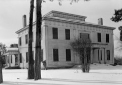 | Barton Hall | 2.3 miles | 1973 |
| Buzzard Roost | 3.4 miles | 1976 |
| National Archives record | The nomination case file for reference 100003107 in Record Group 79. |
| Colbert County | All 29 listed properties in this county. |