 Block
From the record
One of 27 National Register listings published here for Talladega County · listed in 2023 · category: District.
Sources: the National Register database, National Park Service
Listed on the National Register of Historic Places in 2023.
One of 27 National Register listings published here for Talladega County · listed in 2023 · category: District.
Sources: the National Register database, National Park Service
Regional context, not property-specific evidence. The federal wildfire occurrence database lists 190 fires within 5 miles of Talladega County High School between 1994 and 2020, burning about 2,260 acres in total. 2 started naturally. 52 were recorded as arson. Distance is straight-line from the map coordinates, so a fire counted here may appear on a neighbouring settlement's page as well.
| Reported cause | Fires |
|---|---|
| Debris and open burning | 72 |
| Arson/incendiarism | 52 |
| Missing data/not specified/undetermined | 29 |
| Recreation and ceremony | 17 |
| Equipment and vehicle use | 6 |
| Misuse of fire by a minor | 4 |
| Smoking | 4 |
| Other causes | 3 |
| Natural | 2 |
| Railroad operations and maintenance | 1 |
The most recent of them, most recent first, with the day each was reported and the service that recorded it.
| Date | Cause | Size | Reported by | Name on the report |
|---|---|---|---|---|
| 7 September 2020 | Debris and open burning | 8.0 acres | Alabama Forestry Commission | 20200907-2 |
| 7 September 1997 | Debris and open burning | 4.0 acres | Alabama Forestry Commission | not named |
| 6 September 2002 | Debris and open burning | 9.5 acres | Alabama Forestry Commission | not named |
| 3 September 1998 | Equipment and vehicle use | 15 acres | Alabama Forestry Commission | not named |
| 29 September 2004 | Debris and open burning | under an acre | Alabama Forestry Commission | not named |
| 29 September 2000 | Railroad operations and maintenance | 4.0 acres | Alabama Forestry Commission | not named |
| 25 September 1999 | Arson/incendiarism | under an acre | Alabama Forestry Commission | not named |
| 20 September 2019 | Missing data/not specified/undetermined | 20 acres | Alabama Forestry Commission | 20190920-25 |
Regional context, not property-specific evidence. The federal mineral resources record lists 6 workings within 5 miles of Talladega County High School: 4 unknowns, 1 producer, 1 past producer. 1 still produces. What was taken out: Iron, Sand and Gravel, Construction. Distance is straight-line from the map coordinates, so a quarry counted here may appear on a neighbouring settlement's page as well.
| Where | Site | Commodity | Status | Recorded |
|---|---|---|---|---|
| Unnamed Quarry | Sand and Gravel, Construction | Producer | Quartz | |
| Rozelle-Holmes Mine | Iron | Past Producer | ||
| Unnamed | Iron | Unknown | ||
| Unnamed | Iron | Unknown | ||
| Unnamed | Iron | Unknown | ||
| Unnamed | Iron | Unknown |
Regional context, not property-specific evidence. The National Weather Service names Lincoln, the town this property stands in, in 59 storm reports between 1994 and 2025: 33 thunderstorm wind, 19 hail, 4 tornado, 2 flash flood. The reports record 1 death and 2 injuries. Each account below is quoted exactly as the forecast office filed it, from the NOAA Storm Events Database, and each date opens the federal record of that event.
| When | Event | Place named | Harm | What the report says |
|---|---|---|---|---|
| June 1994 | Thunderstorm Wind | Lincoln | 1 killed, $500,000 | Numerous large trees were downed by thunderstorm wind in the northern section of the county near Lincoln. One tree fell on a truck resulting in one fatality. Large hail was also reported with the storm which came up rapidly and lasted only a brief time according to EMA officials. |
| May 1995 | Tornado (F0) | Lincoln | 1 hurt, $10,000 | A weak tornado occurred in northern Talladega County about two miles northeast of Lincoln. The tornado downed numerous trees, and several structures sustained minor damage. One person was injured when she was lifted into the air and dropped while trying to reach her storm shelter. Numerous people reported seeing a funnel cloud at the time. |
| June 2009 | Thunderstorm Wind | Lincoln | 1 hurt, $3,000 | Several trees were blown down in Lincoln. The glass was blown out of a window of a mobile home, injuring the occupant. |
| November 2004 | Tornado (F2) | Lincoln | $125,000 | no account filed |
| February 2008 | Thunderstorm Wind | Lincoln | $100,000 | Widespread wind damage was reported across the northern portion of Talladega County, from near Lincoln eastward to Munford, and as far south as the city of Talladega. Damage consisted mostly of trees and power lines that were blown down, some of which fell onto structures. One mobile home had its roof peeled off in the Bemiston Community. |
| May 2003 | Thunderstorm Wind | Lincoln | $78,000 | Numerous trees were blown down in Lincoln near Interstate 20 and mile marker 169. A few of the trees temporarily blocked roadways. One mobile home was destroyed. One home was destroyed. Several barns and outbuildings were damaged. Several funnel clouds were also reported across northern Talladega County at this time. |
| August 2001 | Tornado (F1) | Lincoln | $75,000 | A small tornado touched down in a wooded area just southwest of exit 165 on Interestate 20. The tornado moved northeast moving across three structures on the south side of the Interstate, two of the structures suffered extensive damage. The tornado moved across CR 207 where several trees were downed and a small portion of the roof of an unoccupied building was damaged. It crossed two mobile home parks, downing trees, ripping pieces of siding from several mobile homes, and pushing one off it's foundation. It crossed US 78 where another mobile home had some siding ripped away from it. It moved through an open area that was inaccessible and then damaged several trees on the north side of the town of Lincoln. No additional damage was found beyond that point. The weak tornado came out of a bowing echo that also caused some damage mainly to trees in Calhoun County. Beginning: 33 35.333N 86 10.056W Ending: 33 37.564N 86 07.641W |
| November 2004 | Tornado (F0) | Lincoln | $60,000 | no account filed |
| April 1996 | Thunderstorm Wind | Lincoln | $35,000 | no account filed |
| August 2002 | Thunderstorm Wind | Lincoln | $15,000 | Several trees were blown down near Pier 59 on Lake Martin. One boat was also destroyed. |
| March 1996 | Hail | Lincoln | $15,000 | no account filed |
| June 2002 | Thunderstorm Wind | Lincoln | $11,000 | A large tree fell on house causing moderate damage. No injuries were reported. |
| August 2008 | Thunderstorm Wind | Lincoln | $10,000 | Several trees were blown down onto a residence on Chestnut Street, in Lincoln. |
| May 1998 | Hail | Lincoln | $10,000 | Golf ball size hail was reported in Lincoln. |
| May 1997 | Thunderstorm Wind | Lincoln | $8,000 | The entire city of Lincoln was without power due to trees on power lines. |
| January 1997 | Hail | Lincoln | $7,000 | no account filed |
| August 1999 | Thunderstorm Wind | Lincoln | $6,000 | Several trees were blown down around the city of Lincoln. A few trees blocked roadways. |
| April 2005 | Thunderstorm Wind | Lincoln | $6,000 | no account filed |
| April 2011 | Thunderstorm Wind | Lincoln | $4,000 | Strong winds caused structural damage along Embry Bend Rd. |
| September 2000 | Thunderstorm Wind | Lincoln | $4,000 | Several trees were blown down near Lincoln. SR 77 was temporarily blocked by a few of the downed trees. |
| April 2011 | Thunderstorm Wind | Lincoln | $3,000 | Trees were blown down along Shelton Shores Road. |
| July 2005 | Thunderstorm Wind | Lincoln | $3,000 | Several trees were blown down in Lincoln. |
| December 2005 | Hail | Lincoln | $3,000 | Golf ball size hail fell at the Talladega Super Speedway. |
| April 1997 | Hail | Lincoln | $3,000 | Dime size hail was reported in Lincoln. |
| April 2011 | Thunderstorm Wind | Lincoln | $2,000 | Trees were downed on McCaig Road at Highway 77. |
| April 2009 | Thunderstorm Wind | Lincoln | $2,000 | Trees and power lines were blown down in Lincoln. |
| February 2006 | Flash Flood | Lincoln | $2,000 | US Highway 78 and State Highway 77 in Lincoln were covered with water and were temporarily impassable. Mudd Street and Cobb Lane were also impassable. |
| July 2006 | Thunderstorm Wind | Lincoln | $2,000 | Phone lines were blown down. |
| June 2001 | Hail | Lincoln | $2,000 | Golf ball size hail was observed in Lincoln. |
| May 2009 | Thunderstorm Wind | Lincoln | $1,000 | Power lines were blown down on Cricket Lane, in Lincoln. |
| August 2008 | Thunderstorm Wind | Lincoln | $1,000 | Several trees were blown down and blocked Patton Chapel Road, north of Lincoln. |
| February 2003 | Thunderstorm Wind | Lincoln | $1,000 | A few trees were blown down around the city of Lincoln. |
| March 2002 | Thunderstorm Wind | Lincoln | $1,000 | A few trees were blown down near the Old Lincoln Highway and Sims Road. |
| December 2000 | Thunderstorm Wind | Lincoln | $1,000 | A few trees were blown down and temporarily blocked a roadway in Lincoln. |
| April 2005 | Hail | Lincoln | $1,000 | no account filed |
| June 2025 | Thunderstorm Wind | Lincoln | - | Trees were downed in the Lincoln area. |
| August 2024 | Thunderstorm Wind | Lincoln | - | Trees were downed in various spots across northern Talladega County, some involving blocked roadways. |
| July 2022 | Thunderstorm Wind | Lincoln | - | Several trees uprooted and power lines downed along Highway 78 in Lincoln. |
| April 2021 | Thunderstorm Wind | Lincoln | - | Several trees uprooted in the city of Lincoln. |
| January 2020 | Thunderstorm Wind | Lincoln | - | Partial roof off house on Taryn Trace Road in the city of Lincoln. Numerous trees uprooted around the city of Lincoln. |
| July 2020 | Thunderstorm Wind | Lincoln | - | Numerous trees uprooted across northern Talladega County, between the cities of Lincoln and Talladega. |
| August 2020 | Thunderstorm Wind | Lincoln | - | Several trees uprooted along Stemley Road. |
| February 2019 | Flood | Lincoln | - | Heavy rainfall over a several day period produced flooding along the Coosa River. Many tributaries connected to the Coosa River also flooded, resulting in many road closures around the city of Lincoln. |
| April 2014 | Flash Flood | Lincoln | - | Three to four inches of rain fell across Talladega County, leading to flash flooding. Numerous roads were impassable for a short time until waters receded. Water flowed into the Talladega City Hall basement. A culvert was washed out in Sylacauga. Water invaded two homes in Alpine and one in Lincoln. |
| July 2012 | Thunderstorm Wind | Lincoln | - | A tree was blown down, blocking one lane on Interstate 20, near exit 162. |
| June 2012 | Thunderstorm Wind | Lincoln | - | A tree was reported down on Water Tank Lane. |
| July 2012 | Thunderstorm Wind | Lincoln | - | A few trees were reported down near Cook Springs. |
| June 2005 | Hail | Lincoln | - | Nickel size hail was reported at a food mart in Lincoln. The hail lasted almost ten minutes. |
| December 2005 | Hail | Lincoln | - | Penny size hail was observed near the Country Club Estates on Logan Martin Lake. |
| October 2004 | Hail | Lincoln | - | Penny to nickle size hail was observed across northern Talladega County from near Lincolnto near Munford. |
| March 2003 | Hail | Lincoln | - | Penny size hail fell in the city of Lincoln. |
| May 2003 | Hail | Lincoln | - | Penny size hail was reported in and around the city of Lincoln. |
| November 2002 | Hail | Lincoln | - | Dime size hail was reported at the intersection of CR 207 and Interstate 20. |
| January 1999 | Hail | Lincoln | - | Dime size hail was reported north of Lincoln along SR 77 near the Calhoun County border. |
| April 2017 | Hail | Lincoln | - | no account filed |
| March 2015 | Hail | Lincoln | - | no account filed |
| March 2013 | Hail | Lincoln | - | no account filed |
| February 2009 | Hail | Lincoln | - | no account filed |
| August 2008 | Hail | Lincoln | - | no account filed |
No historic map-sheet match is published for this property yet. That does not mean no map exists. This record needs a coordinate-quality review before it can be joined to a sheet boundary. Browse the county's mapped places while that work is pending.
Other National Register properties close enough to walk or drive between, ordered by distance from this one. Both positions come from the same geocoding pass that matched these properties to their map sheets.
| Photograph | Property | Distance | Listed |
|---|---|---|---|
 | Jemison House Complex | 6.6 miles | 1990 |
| Elston House | 7.1 miles | 1976 | |
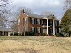 | Idlewild | 7.9 miles | 1993 |
| National Archives record | The nomination case file for reference 100009127 in Record Group 79. |
| Talladega County | All 27 listed properties in this county. |