 Block
From the record
One of 6 National Register listings published here for Lowndes County · listed in 2023 · category: Site.
Sources: the National Register database, National Park Service
Listed on the National Register of Historic Places in 2023.
One of 6 National Register listings published here for Lowndes County · listed in 2023 · category: Site.
Sources: the National Register database, National Park Service
Regional context, not property-specific evidence. The federal wildfire occurrence database lists 93 fires within 5 miles of Campsite 2: Rosie Steele Property between 1994 and 2019, burning about 643 acres in total. None started naturally. 8 were recorded as arson. Distance is straight-line from the map coordinates, so a fire counted here may appear on a neighbouring settlement's page as well.
| Reported cause | Fires |
|---|---|
| Debris and open burning | 36 |
| Recreation and ceremony | 13 |
| Missing data/not specified/undetermined | 11 |
| Equipment and vehicle use | 10 |
| Arson/incendiarism | 8 |
| Smoking | 7 |
| Misuse of fire by a minor | 7 |
| Other causes | 1 |
The most recent of them, most recent first, with the day each was reported and the service that recorded it.
| Date | Cause | Size | Reported by | Name on the report |
|---|---|---|---|---|
| 9 September 2010 | Debris and open burning | 38 acres | Alabama Forestry Commission | not named |
| 7 September 1998 | Arson/incendiarism | 43 acres | Alabama Forestry Commission | not named |
| 5 September 2000 | Debris and open burning | 2.0 acres | Alabama Forestry Commission | not named |
| 5 September 1995 | Recreation and ceremony | 2.0 acres | Alabama Forestry Commission | not named |
| 24 September 2019 | Debris and open burning | 2.3 acres | Alabama Forestry Commission | 20190924-19 |
| 23 September 1999 | Debris and open burning | 10 acres | Alabama Forestry Commission | not named |
| 20 September 1995 | Smoking | 9.0 acres | Alabama Forestry Commission | not named |
| 2 September 1995 | Recreation and ceremony | 1.3 acres | Alabama Forestry Commission | not named |
Regional context, not property-specific evidence. The federal mineral resources record lists 2 workings within 5 miles of Campsite 2: Rosie Steele Property: 2 producers. All of them still produce. What was taken out: Sand and Gravel, Construction. Distance is straight-line from the map coordinates, so a quarry counted here may appear on a neighbouring settlement's page as well.
| Where | Site | Commodity | Status | Recorded |
|---|---|---|---|---|
| White Hall Pit | Sand and Gravel, Construction | Producer | ||
| White Hall Quarry | Sand and Gravel, Construction | Producer | Unconsolidated Sediments |
Regional context, not property-specific evidence. The National Weather Service names White Hall, the town this property stands in, in 14 storm reports between 2000 and 2022: 7 thunderstorm wind, 5 hail, 1 tornado, 1 flash flood. The reports record 1 injury. Each account below is quoted exactly as the forecast office filed it, from the NOAA Storm Events Database, and each date opens the federal record of that event.
| When | Event | Place named | Harm | What the report says |
|---|---|---|---|---|
| April 2005 | Tornado (F1) | White Hall | 1 hurt, $110,000 | National Weather Service meteorologists surveyed the damage across northwestern Lowndes County. It was determined that the damage was the result of a tornado that has been rated F1 on the Fujita Scale. The tornado first touched down near Mount Gillard Church, near the Intersection of US 80 and CR 17 around 652 AM CDT. It stayed on the ground for only about a minute, before lifting around 653 AM CDT. The total path length was 1.6 miles with a width of 50 yards at its widest point. This path was parallel to CR 17, with most of the damage on the northwest side of the road. This tornado, with winds estimated around 100 mph, uprooted or snapped dozens of trees, damaged 2 mobile homes severely...produced minor damage to 3 homes and caused severe roof damage to another home. The side of one of the mobile homes was breached by an unidentified piece of debris, resulting in a 7 foot by 3 foot hole. The most substantial damage to a home consisted of approximately one third of the roof being blown off, which resulted in the partial collapse of an exterior wall. One middle aged man was injured in this home but did not seek medical treatment. Begin: 32 16.51/86 44.88 End: 32 17.17/86 43.49 |
| April 2005 | Thunderstorm Wind | White Hall | $26,000 | Several trees were blown down across the eastern half of Lowndes County. This damage was not concentrated but was from the same line of storms that produced the damage near Mosses and White Hall. |
| April 2005 | Hail | White Hall | $5,000 | Hail up to the size of golf balls fell across northern Lowndes County. The was the second large hail producing storm to move across the same general area within a few hours. |
| April 2005 | Hail | White Hall | $5,000 | Hail up to the size of golf balls fell across extreme northern Lowndes County. |
| April 2005 | Thunderstorm Wind | White Hall | $3,000 | A few trees were blown down in and near White Hall. |
| April 2000 | Hail | White Hall | $3,000 | Quarter size hail was observed in White Hall. |
| June 2008 | Thunderstorm Wind | White Hall | $2,000 | A few trees were blown down near the White Hall Community. |
| July 2007 | Thunderstorm Wind | White Hall | $2,000 | Several trees and powerlines were downed in the Whitehall and Rudolph Communities. |
| August 2000 | Thunderstorm Wind | White Hall | $2,000 | Several trees and power lines were blown down along CR 12 and CR 23 near White Hall. |
| July 2008 | Thunderstorm Wind | White Hall | $1,000 | A few trees were blown down north of the White Hall Community. |
| July 2022 | Thunderstorm Wind | White Hall | - | Multiple trees uprooted in the town of White Hall. |
| September 2011 | Flash Flood | White Hall | - | Water was reported across Henderson Road, making the road impassable. |
| March 2005 | Hail | White Hall | - | Penny size hail was reported near the White Hall community in northern Lowndes County. |
| April 2003 | Hail | White Hall | - | Supercell 6 continued across the rural terrain of northern Lowndes County. The largest hail size reported was quarters. This storm also produced small hail across southern Autauga County from pea to dime size around Autaugaville. |
No historic map-sheet match is published for this property yet. That does not mean no map exists. This record needs a coordinate-quality review before it can be joined to a sheet boundary. Browse the county's mapped places while that work is pending.
Other National Register properties close enough to walk or drive between, ordered by distance from this one. Both positions come from the same geocoding pass that matched these properties to their map sheets.
| Photograph | Property | Distance | Listed |
|---|---|---|---|
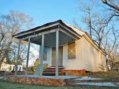 | Lowndesboro | 6.2 miles | 1973 |
| National Archives record | The nomination case file for reference 100009549 in Record Group 79. |
| Lowndes County | All 6 listed properties in this county. |