 Block
From the record
One of 13 National Register listings published here for Elmore County · listed in 2013 · category: Building.
Sources: the National Register database, National Park Service
Listed on the National Register of Historic Places in 2013.
One of 13 National Register listings published here for Elmore County · listed in 2013 · category: Building.
Sources: the National Register database, National Park Service
Regional context, not property-specific evidence. The federal wildfire occurrence database lists 77 fires within 5 miles of Ellerslie between 1994 and 2018, burning about 346 acres in total. 1 started naturally. 8 were recorded as arson. Distance is straight-line from the map coordinates, so a fire counted here may appear on a neighbouring settlement's page as well.
| Reported cause | Fires |
|---|---|
| Missing data/not specified/undetermined | 22 |
| Debris and open burning | 19 |
| Misuse of fire by a minor | 11 |
| Arson/incendiarism | 8 |
| Railroad operations and maintenance | 7 |
| Equipment and vehicle use | 7 |
| Recreation and ceremony | 2 |
| Natural | 1 |
The most recent of them, most recent first, with the day each was reported and the service that recorded it.
| Date | Cause | Size | Reported by | Name on the report |
|---|---|---|---|---|
| 7 September 1998 | Equipment and vehicle use | under an acre | Alabama Forestry Commission | not named |
| 29 September 2013 | Missing data/not specified/undetermined | 1.0 acres | Alabama Forestry Commission | ECR-20130929-001 |
| 23 September 2010 | Equipment and vehicle use | 15 acres | Alabama Forestry Commission | not named |
| 23 September 1999 | Misuse of fire by a minor | under an acre | Alabama Forestry Commission | not named |
| 22 September 2010 | Arson/incendiarism | 3.5 acres | Alabama Forestry Commission | not named |
| 15 September 1999 | Arson/incendiarism | 126 acres | Alabama Forestry Commission | not named |
| 11 September 2002 | Debris and open burning | 4.0 acres | Alabama Forestry Commission | not named |
| 27 August 2000 | Missing data/not specified/undetermined | under an acre | Alabama Forestry Commission | not named |
Regional context, not property-specific evidence. The federal mineral resources record lists 28 workings within 5 miles of Ellerslie: 22 producers, 5 past producers, 1 unknown. 22 still produce. What was taken out: Sand and Gravel, Construction, Clay, Titanium, Metal, Zirconium, Kyanite, REE, Titanium, Metal, Zirconium, Kyanite. Distance is straight-line from the map coordinates, so a quarry counted here may appear on a neighbouring settlement's page as well.
| Where | Site | Commodity | Status | Recorded |
|---|---|---|---|---|
| Alabama River | Sand and Gravel, Construction, Titanium, Metal, Zirconium, Kyanite | Producer | Quartz | |
| Dixie Sand & Gravel - Maxwell Pit | Sand and Gravel, Construction, Titanium, Metal, Zirconium, Kyanite, REE | Producer | Quartz | |
| French Street Brick Plant | Fire Clay (Refractory) | Past Producer | ||
| Browder Pit | Clay | Producer | ||
| Excelsior Mine | Clay | Producer | ||
| Gober Pit Jenkins Brick Company | Clay | Producer | ||
| Coosada Ferry Pit | Sand and Gravel, Construction | Producer | Quartz | |
| Dixie Sand & Gravel Co. Pit | Sand and Gravel, Construction | Past Producer | ||
| Dozier Pit | Sand and Gravel, Construction | Producer | ||
| Dredge No. 1 | Sand and Gravel, Construction | Unknown |
Regional context, not property-specific evidence. The National Weather Service names Millbrook, the town this property stands in, in 59 storm reports between 1996 and 2023: 22 hail, 22 thunderstorm wind, 9 flash flood, 3 lightning. The reports record 1 death and 2 injuries. Each account below is quoted exactly as the forecast office filed it, from the NOAA Storm Events Database, and each date opens the federal record of that event.
| When | Event | Place named | Harm | What the report says |
|---|---|---|---|---|
| March 1999 | Thunderstorm Wind | Millbrook | 1 killed, $135,000 | Strong thunderstorm wind downed numerous trees along CR2 just west of the intersection with SR 143. At that intersection, a number of very large trees were uprooted falling on several mobile homes. A 23-year-old man was killed when one of the trees fell on his mobile home crushing him while he slept. Additional tree damage occurred east of the mobile home park producing a path of damage about 1.7 miles long. Minor roof damage also occurred to several structures west of SR 143 along CR 2. |
| July 2012 | Thunderstorm Wind | Millbrook | 1 hurt | A patio cover was blown down, causing minor damage to the home and injuring the resident. |
| April 2007 | Lightning | Millbrook | 1 hurt | One person was struck by lightning near Emerald Mountain. The person was working in a house under construction. |
| May 2009 | Flash Flood | Millbrook | $4,900,000 | Numerous county roads and city streets became impassable and suffered extensive damage due to flooding caused by torrential rainfall. The cities of Wetumpka, Millbrook, and Deatsville were especially hard hit. At least 43 homes, 10 business, and 2 churches also suffered damage due to the flooding. The Millbrook city parks and recreation areas suffered substantial damage. |
| November 2004 | Tornado (F0) | Millbrook | $122,000 | no account filed |
| February 2008 | Tornado (EF1) | Millbrook | $100,000 | The Prattville Tornado continued into Elmore County near Millbrook. It continued its northeast motion, and crossed Interstate 65 and AL-14. It then veered to the left, and moved almost due north for several more miles, before lifting just west of Speigner Lake. In Elmore County, the tornado snapped and uprooted several trees and produced generally light structural damage to several buildings. |
| April 2003 | Hail | Millbrook | $50,000 | The supercell thunderstorm remained very strong as it moved across extreme southwest Elmore County. Hail up to the size of baseballs fell across the area generally the southern side of Millbrook down to the Alabama River. Several automobiles were damaged. |
| July 2005 | Flash Flood | Millbrook | $22,000 | Several roads in Millbrook were flooded and were temporarily impassable. One local business sustained flood damage. |
| March 2005 | Hail | Millbrook | $18,000 | Hail up to the size of golf balls fell from near Millbrook all the way to the county line at Lake Martin. |
| February 1999 | Thunderstorm Wind | Millbrook | $15,000 | A few trees were downed including one that fell on the police chief's truck. |
| January 1997 | Thunderstorm Wind | Millbrook | $15,000 | no account filed |
| July 2003 | Lightning | Millbrook | $12,000 | A home was struck by lightning in Millbrook. The house sustained minor damage. |
| December 1996 | Flash Flood | Millbrook | $10,000 | no account filed |
| March 1996 | Hail | Millbrook | $10,000 | no account filed |
| May 2009 | Thunderstorm Wind | Millbrook | $6,000 | Several trees and power lines were blown down in Millbrook. Some of the fallen trees blocked roads, and one tree fell onto a home causing minor damage. |
| July 2005 | Flash Flood | Millbrook | $6,000 | A few roads were flooded and were temporarily impassable in and around Millbrook. |
| August 2002 | Lightning | Millbrook | $6,000 | Two homes were struck by lightning and received minor damage. One tree was knocked down due to a lightning strike. |
| July 2010 | Thunderstorm Wind | Millbrook | $5,000 | Power lines were blown down across Alabama Highway 143 in Millbrook. |
| April 2007 | Hail | Millbrook | $5,000 | One porch was damaged and a bay window was blown out of a home due to hail. |
| March 2000 | Hail | Millbrook | $5,000 | Nickel to golfball size hail was reported in and around the city of Millbrook. |
| March 1998 | Thunderstorm Wind | Millbrook | $5,000 | A 30 to 40 foot antenna was blown down and numerous trees were blown down in a path about 150 yards long. |
| November 2010 | Thunderstorm Wind | Millbrook | $4,000 | Several trees were blown down on Edgewood Road and on Grandview Road, in Millbrook. |
| February 2001 | Thunderstorm Wind | Millbrook | $3,000 | Several trees were blown down in the Millbrook area. |
| June 1999 | Flash Flood | Millbrook | $3,000 | Many streets in downtown Millbrook were flooded from a one to three inches of rain in a short period of time. |
| May 2011 | Thunderstorm Wind | Millbrook | $2,000 | Trees and power lines were blown down in Millbrook. |
| June 2007 | Thunderstorm Wind | Millbrook | $2,000 | A few trees were blown down across the road by gust front winds. |
| July 2006 | Thunderstorm Wind | Millbrook | $2,000 | Trees were blown down on Airport Road. |
| August 1997 | Hail | Millbrook | $2,000 | Dime to nickel size hail was reported 1 mile north of the Elmore/Montgomery county line. |
| July 2000 | Thunderstorm Wind | Millbrook | $2,000 | no account filed |
| July 2009 | Thunderstorm Wind | Millbrook | $1,000 | A tree was blown down across Main Street, in the city of Millbrook near the post office. |
| September 2008 | Thunderstorm Wind | Millbrook | $1,000 | A few trees were blown down around Millport and Coosada, by winds estimated around 35 mph. |
| June 2011 | Thunderstorm Wind | Millbrook | $500 | A tree was blown down at the Alabama Nature Center in Millbrook. |
| July 2009 | Thunderstorm Wind | Millbrook | $500 | Winds damaged a sign on Interstate 65, near exit 179. |
| June 2023 | Hail | Millbrook | - | Quarter size hail reported in Millbrook. |
| June 2022 | Thunderstorm Wind | Millbrook | - | Several trees uprooted and power lines downed in Millbrook. |
| May 2021 | Tornado (EF1) | Millbrook | - | National Weather Service meteorologists surveyed damage in extreme southwest Elmore County and determined that it was consistent with an EF1 tornado, with maximum winds near 100 mph. This tornado began in Autauga County and crossed into Elmore County near Castle Brook Drive. Soon after crossing into Elmore County, the tornado made a turn to the southeast at Old Farm Road and crossed over I-65. The tornado produced its highest winds along the I-65 corridor where numerous trees were uprooted and snapped. Some homes were heavily damaged by fallen trees. The tornado continued southeast and crossed Cobbs Ford Road where some buildings had loss of metal roofing. The tornado then crossed Alabama River Parkway before crossing into Montgomery County at the Alabama River. |
| April 2020 | Thunderstorm Wind | Millbrook | - | Several trees uprooted in the city of Millbrook. |
| March 2017 | Thunderstorm Wind | Millbrook | - | Several trees uprooted in the town of Millbrook. |
| June 2017 | Flash Flood | Millbrook | - | Cooter Pond Road flooded due to Pine Creek overflowing its banks and the adjacent Mobile Home Park also flooded. |
| April 2016 | Flash Flood | Millbrook | - | This flash flood event is a continuation of an event from March 31st. |
| March 2016 | Flash Flood | Millbrook | - | Heavy rainfall over a several hour period produced flash flooding over southwest Elmore county. Portions of State Highway 143 between Duncan Road and Highway 14 were underwater and closed. The flash flood event continues into April 1st. |
| March 2013 | Thunderstorm Wind | Millbrook | - | Several trees were uprooted in Millbrook. |
| April 2011 | Thunderstorm Wind | Millbrook | - | Winds were estimated. |
| May 2010 | Flash Flood | Millbrook | - | Several roads around the city of Millbrook became flooded due to heavy rainfall. |
| May 2005 | Hail | Millbrook | - | Penny size hail fell in and around Millbrook. |
| December 2005 | Hail | Millbrook | - | Nickel size hail was observed in and around Millbrook. |
| April 2004 | Hail | Millbrook | - | Quarter size hail was observed from near Interstate 65 to near Millbrook. |
| May 2002 | Hail | Millbrook | - | Pea to dime size hail was observed just west of Millbrook. |
| April 2014 | Hail | Millbrook | - | no account filed |
| March 2011 | Hail | Millbrook | - | no account filed |
| March 2011 | Hail | Millbrook | - | no account filed |
| July 2009 | Hail | Millbrook | - | no account filed |
| April 2008 | Hail | Millbrook | - | no account filed |
| April 2007 | Hail | Millbrook | - | no account filed |
| April 2007 | Hail | Millbrook | - | no account filed |
| April 2006 | Hail | Millbrook | - | no account filed |
| April 2006 | Hail | Millbrook | - | no account filed |
| August 2006 | Hail | Millbrook | - | no account filed |
| July 2000 | Hail | Millbrook | - | no account filed |
No historic map-sheet match is published for this property yet. That does not mean no map exists. This record needs a coordinate-quality review before it can be joined to a sheet boundary. Browse the county's mapped places while that work is pending.
Other National Register properties close enough to walk or drive between, ordered by distance from this one. Both positions come from the same geocoding pass that matched these properties to their map sheets.
| Photograph | Property | Distance | Listed |
|---|---|---|---|
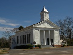 | Robinson Springs United Methodist Church | 6.3 miles | 1982 |
| National Archives record | The nomination case file for reference 13000957 in Record Group 79. |
| Elmore County | All 13 listed properties in this county. |