BlockBefore
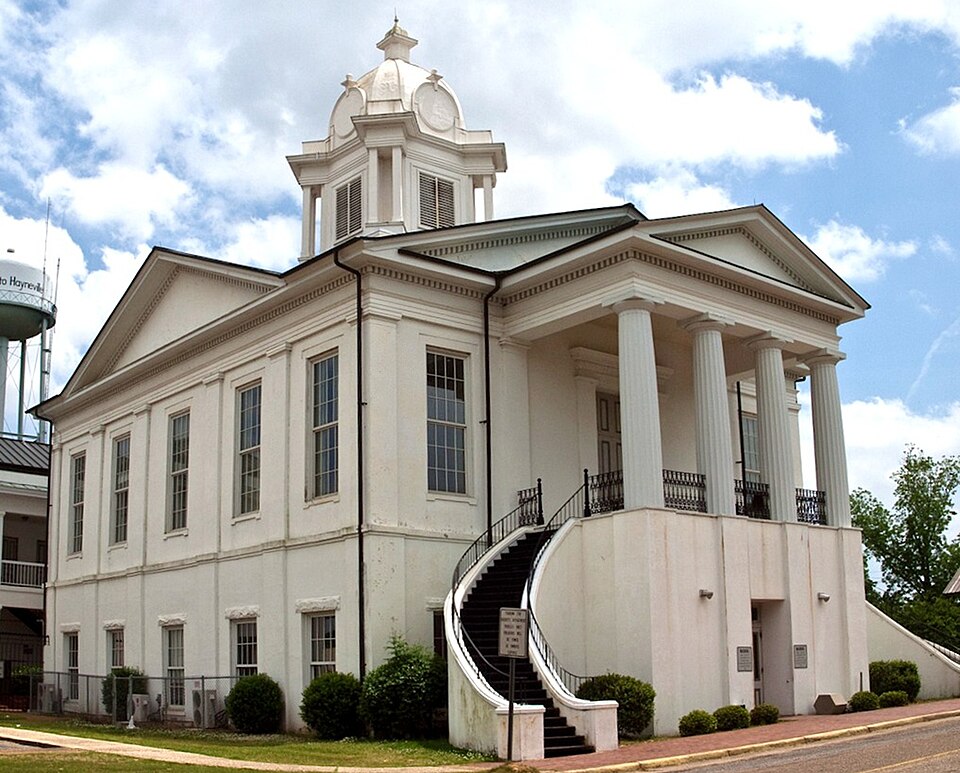
Photograph of Lowndes County Courthouse
Photograph by Altairisfar, CC BY-SA 3.0. Via Wikimedia Commons.

Lowndes County Courthouse

Listed on the National Register of Historic Places in 1971.

From the record

One of 6 National Register listings published here for Lowndes County · listed in 1971 · category: Building.

Sources: the case file at the National Archives · the National Register database, National Park Service · the Wikipedia article

The listing

  • What is counted as historic. The nomination lists 1 building as contributing to the listing.
  • Address. Washington St., Hayneville, 36040
  • When was it listed? June 1971
  • Category. building
  • Census division. Hayneville
  • Architectural style. Greek Revival architecture
  • National Register reference number. 71000100 - the number the National Park Service assigned this property when it was listed, and the key its nomination file is catalogued under at the National Archives.

Fires near this property

66 since 1994

Regional context, not property-specific evidence. The federal wildfire occurrence database lists 66 fires within 5 miles of Lowndes County Courthouse between 1994 and 2020, burning about 415 acres in total. None started naturally. 3 were recorded as arson. Distance is straight-line from the map coordinates, so a fire counted here may appear on a neighbouring settlement's page as well.

Reported cause Fires
Debris and open burning24
Missing data/not specified/undetermined13
Equipment and vehicle use10
Smoking8
Recreation and ceremony5
Arson/incendiarism3
Misuse of fire by a minor2
Railroad operations and maintenance1

The most recent of them, most recent first, with the day each was reported and the service that recorded it.

DateCause SizeReported by Name on the report
7 September 2019Debris and open burning20 acresAlabama Forestry Commission20190907-2
6 September 2005Debris and open burning1.0 acresAlabama Forestry Commissionnot named
29 September 2008Equipment and vehicle use1.0 acresAlabama Forestry Commissionnot named
19 September 2002Equipment and vehicle useunder an acreAlabama Forestry Commissionnot named
18 September 1995Smokingunder an acreAlabama Forestry Commissionnot named
16 September 1998Debris and open burning2.0 acresAlabama Forestry Commissionnot named
11 September 2005Equipment and vehicle use6.0 acresAlabama Forestry Commissionnot named
5 August 1998Smokingunder an acreAlabama Forestry Commissionnot named

Every fire recorded in Lowndes County

Storms near this property

31 since 1995

Regional context, not property-specific evidence. The National Weather Service names Hayneville, the town this property stands in, in 31 storm reports between 1995 and 2019: 15 thunderstorm wind, 12 hail, 2 flash flood, 2 tornado. The reports record 4 injuries. Each account below is quoted exactly as the forecast office filed it, from the NOAA Storm Events Database, and each date opens the federal record of that event.

WhenEvent Place namedHarm What the report says
April 2005Thunderstorm WindHayneville4 hurt, $100,000National Weather Service meteorologists surveyed the damage across Central Lowndes County. Thedamage was determined to be the result of straight line thunderstorm winds. Damage was first observedalong County Road 17 between Panther Creek and Ash Creek Church. Damage continued eastward along County Road 13 for approximately 4 miles. Extensive tree damage was observed along this entire area. No evidence of rotation was observed. Additionally...more concentrated damage was discovered to two mobile homes and one old pillar and beam constructed home near Cherry Street. Both of the mobile homes were completely destroyed with debris scattered up to one hundred yards downwind. Four injuriesoccurred in these homes, two middle aged females, a 2 year old girl and a 5 year old boy. Injuries were mostly cuts and bruises, although the five year old sustained several broken bones. A witness reported that the 5 year old was blown a considerable distance from the mobile home. The tin roof of the traditional home was completely removed. These residences were located atop a hill which likely enhanced the winds.
November 1997Thunderstorm WindHayneville$35,000Several trees were down in the Farmersville community, including one, which trapped someone in a car. There were no injuries
March 1999Thunderstorm WindHayneville$15,000Trees and power lines were knocked down and a few outbuildings were destroyed in the Beechwood Community off CR 21.
March 1996HailHayneville$15,000no account filed
May 2009Thunderstorm WindHayneville$10,000Numerous trees were blown down across Lowndes County. Many of the fallen trees blocked roadways. A few trees fell on vehicles and homes.
November 2011Thunderstorm WindHayneville$5,000Several trees were reported down with numerous power outages in Hayneville.
April 2003Thunderstorm WindHayneville$5,000A few trees were blown down along SR 21 near the intersection of CR 33.
June 1998Thunderstorm WindHayneville$5,000Power lines were down in Hayneville.
January 2001Thunderstorm WindHayneville$3,000Trees and power lines were blown down near Gordonsville and in Hayneville.
July 1995Thunderstorm WindHayneville$3,000A swath of trees were reported down on the Lowndes/Montgomery County line along Interstate 65.
June 2008Thunderstorm WindHayneville$2,000A few trees were blown down, in and around Hayneville.
July 2005Flash FloodHayneville$2,000Old Letohatchee Road near Hayneville was flooded and temporarily impassable.
April 2005HailHayneville$1,000Quarter size hail was observed near Hayneville. This was the third storm of the afternoon that broughtlarge hail to north central Lowndes County.
November 2005HailHayneville$1,000Golf ball size hail was observed in the Mosses Community.
August 2000Thunderstorm WindHayneville$1,000A few trees were blown down near Mosses.
June 2008Thunderstorm WindHayneville$500Several trees were blown down Lowndes County.
May 2019Thunderstorm WindHayneville-Several trees uprooted along Highway 21 west of the town of Hayneville.
October 2017Tornado (EF0)Hayneville-NWS meteorologists surveyed damage in central Lowndes County and determined that the damage was consistent with an EF0 tornado. The tornado began near a chicken farm along County Road 33 and moved northwest crossing Alabama Highway 21 where trees were snapped and uprooted. The tornado continued northwest crossing Foster Road. The end of the path had to be estimated as the tornado lifted in a swampy area north of Foster Road or just east of Mosses.
June 2015Thunderstorm WindHayneville-Several trees uprooted along County Road 2.
December 2012Tornado (EF2)Hayneville-The EF-2 tornado touched down on Highway 97 between Hayneville and Lowndesboro. Hundreds of trees were snapped or uprooted in a half-mile wide swath across Highway 97. The tornado continued to the northeast and intensified as it moved over mainly pastureland. Just south of Highway 80, the tornado struck a farm, significantly damaging a large, well-constructed cattle barn. A second large metal cattle barn was mostly destroyed as well. Numerous power poles were snapped or downed along Highway 80. A heavy-duty dumpster was lofted and thrown approximately 250 yards across Highway 80. Tin roofing material and other debris was lofted and blown over one-quarter mile. The tornado continued across Highway 80, damaging multiple homes along Lake Berry Road. One home had the roof largely removed resulting in the cement block foundation cracking. Three to five additional homes had minor roof damage. The tornado continued northeastward toward the old GE Plastics Plant where it mowed down numerous trees and flipped several empty semitrailers onto their sides. The tornado lifted just north of the Gate 1 entrance to the plant and east of County Road 37.
February 2012Thunderstorm WindHayneville-Several large trees were blown down, blocking US Highway 21.
January 2007Flash FloodHayneville-Several locations around Hayneville, and other parts of the county, became temporarily impassable due to high water.
March 2005HailHayneville-Nickel size hail was reported along Interstate 65 in eastern Lowndes County.
April 1998HailHayneville-Penny size hail was reported in Hayneville.
January 2017HailHayneville-no account filed
May 2012HailHayneville-no account filed
February 2012HailHayneville-no account filed
March 2010HailHayneville-no account filed
April 2007HailHayneville-no account filed
March 2007HailHayneville-no account filed

Every storm recorded in Lowndes County

Map coverage status

No historic map-sheet match is published for this property yet. That does not mean no map exists. This record needs a coordinate-quality review before it can be joined to a sheet boundary. Browse the county's mapped places while that work is pending.

Listed places nearby

2 within 8 miles

Other National Register properties close enough to walk or drive between, ordered by distance from this one. Both positions come from the same geocoding pass that matched these properties to their map sheets.

Photograph PropertyDistance Listed
Campsite 3: The Gardner Farm6.3 miles2023
Lowndesboro7.4 miles1973

Sources for this property

National Archives recordThe nomination case file for reference 71000100 in Record Group 79.
Wikipedia articleCommunity-written account of this property, licensed CC BY-SA.
Lowndes CountyAll 6 listed properties in this county.

Provenance

  • Listing record. National Park Service National Register of Historic Places, listed-properties dataset, current to 2026-05-22.
  • Map join. Address geocoded through the United States Census geocoder, then tested against the published boundary of every sheet in the USGS Historical Topographic Map Collection.
  • How this page is made. Listing fields come from federal records; map-sheet coverage is a labelled coordinate-to-boundary calculation, not a source-field claim.
  • Wildfire. Short, Karen C. 2022. Spatial wildfire occurrence data for the United States, 1992-2020 [FPA_FOD_20221014]. 6th Edition. Fort Collins, CO: Forest Service Research Data Archive. https://doi.org/10.2737/RDS-2013-0009.6 Collected with United States Government funding and usable without additional permissions or fees.
  • Storms. NOAA National Centers for Environmental Information, Storm Events Database https://www.ncei.noaa.gov/stormevents/ A work of the United States government, no copyright under 17 U.S.C. 105. Narratives are quoted verbatim from the National Weather Service report and are not edited or summarised.