
BlockBefore
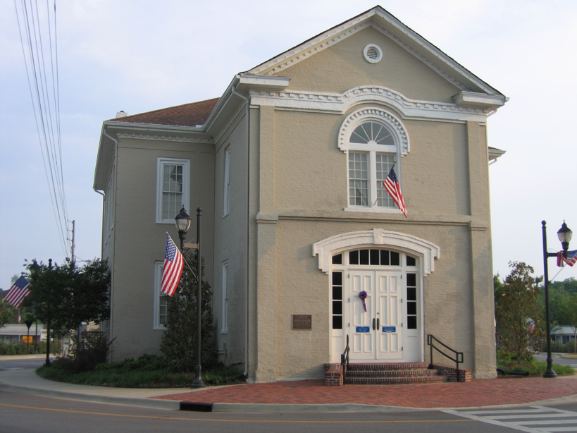
Photograph of Old Shelby County Courthouse
Photograph by Oakshade at English Wikipedia, CC BY-SA 3.0. Via Wikimedia Commons.

Columbiana City Hall

Listed on the National Register of Historic Places in 1974.

From the record

“The Old Shelby County Courthouse, also known as Columbiana City Hall, is a defunct courthouse in Columbiana, Alabama. It served as the courthouse for Shelby County until 1906 when a larger court facility was built.”

Wikipedia article Old Shelby County Courthouse, CC BY-SA 4.0.

One of 13 National Register listings published here for Shelby County · listed in 1974 · category: Building.

Sources: the Wikipedia article · the case file at the National Archives · the National Register database, National Park Service

The listing

  • What is counted as historic. The nomination lists 1 building as contributing to the listing.
  • Address. Main St., Columbiana, 35051
  • When was it listed? October 1974
  • Category. building
  • Census division. Columbiana
  • National Register reference number. 74000437 - the number the National Park Service assigned this property when it was listed, and the key its nomination file is catalogued under at the National Archives.

Fires near this property

209 since 1994

Regional context, not property-specific evidence. The federal wildfire occurrence database lists 209 fires within 5 miles of Columbiana City Hall between 1994 and 2020, burning about 2,483 acres in total. 3 started naturally. 83 were recorded as arson. Distance is straight-line from the map coordinates, so a fire counted here may appear on a neighbouring settlement's page as well.

Reported cause Fires
Arson/incendiarism83
Debris and open burning75
Missing data/not specified/undetermined23
Recreation and ceremony14
Smoking4
Natural3
Railroad operations and maintenance2
Misuse of fire by a minor2
Equipment and vehicle use2
Power generation/transmission/distribution1

The most recent of them, most recent first, with the day each was reported and the service that recorded it.

DateCause SizeReported by Name on the report
9 September 1995Recreation and ceremonyunder an acreAlabama Forestry Commissionnot named
6 September 2019Missing data/not specified/undetermined6.0 acresAlabama Forestry Commission20190906-13
5 September 1995Recreation and ceremony8.0 acresAlabama Forestry Commissionnot named
4 September 2002Missing data/not specified/undetermined6.0 acresAlabama Forestry Commissionnot named
30 September 2001Arson/incendiarismunder an acreAlabama Forestry Commissionnot named
27 September 2019Missing data/not specified/undetermined3.0 acresAlabama Forestry Commission20190927-16
26 September 2019Debris and open burning2.0 acresAlabama Forestry Commission20190926-1
24 September 2004Debris and open burningunder an acreAlabama Forestry Commissionnot named

Every fire recorded in Shelby County

Mines and quarries near this property

10 of 14 shown

Regional context, not property-specific evidence. The federal mineral resources record lists 14 workings within 5 miles of Columbiana City Hall: 8 unknowns, 2 past producers, 2 producers, 1 occurrence. 3 still produce. What was taken out: Iron, Sand and Gravel, Construction, Manganese, Sulfur. Distance is straight-line from the map coordinates, so a quarry counted here may appear on a neighbouring settlement's page as well.

Where SiteCommodity StatusRecorded
(Facility) Tuscaloosa RefinerySulfurPlant
Shelby MineIron, ManganesePast Producer1849
Couch PitSand and Gravel, ConstructionProducer
Tuscaloosa QuarrySand and Gravel, ConstructionProducer
Chain Gang PitIronUnknown
Columbiana MountainIronUnknown
Columbiana Red Ore ProspectIronOccurrenceHematite
Kingdom AreaIronUnknown
Shelby PitIronUnknown
Shelby Pit/Kingdom AreaIronPast ProducerResidual

Every working recorded in Shelby County

Storms near this property

36 since 1996

Regional context, not property-specific evidence. The National Weather Service names Columbiana, the town this property stands in, in 36 storm reports between 1996 and 2026: 22 thunderstorm wind, 8 hail, 3 flash flood, 2 tornado. No death or injury is recorded in these reports. Each account below is quoted exactly as the forecast office filed it, from the NOAA Storm Events Database, and each date opens the federal record of that event.

WhenEvent Place namedHarm What the report says
April 2005Tornado (F1)Columbiana$200,000National Weather Service meteorologists surveyed the damage just northeast of Columbiana. It has been determined that the damage was the result of a tornado. The tornado has been rated an F1 onthe Fujita Damage Scale with winds estimated around 75 miles an hour. The tornado touched down approximately 3 miles northeast of downtown Columbiana, just west of County Road 25 across thetrain tracks. The tornado snapped off and uprooted numerous trees and knocked over several powerpoles along its fairly short path. Some of the trees were several feet in diameter. Fallen treessignificantly damaged one home, produced minor damage to a few other homes, destroyed at least 4 vehicles, and destroyed several outbuildings. The tornado crossed County Road 25 and headed eastwardacross mainly rural farmland. The tornado ended near the intersection of Davis Road and County Road5 where a garage sustained roof damage and one large tree was uprooted. The tornado damage path wasapproximately 2.2 miles long and 150 yards wide at its widest point. The tornado started at 522 AM CDT and ended at 523 AM CDT. Begin: 33 12.98/86 35.39 End: 33 13.13/86 33.20
December 2011Tornado (EF0)Columbiana$45,000National Weather Service meteorologists surveyed damage in Shelby County and assessed damage that was consistent with a tornado. An EF-0 tornado with winds of 70 to 80 mph briefly touched down in Columbiana along County Road 47 and moved northeast for 1.9 miles and lifted along County Road 25. Along its path, 2 homes were damaged due to falling trees, and another home suffered minor shingle damage. Approximately 50 trees were either snapped or uprooted.
June 2009Thunderstorm WindColumbiana$20,000The old National Standard building in Columbiana, which had been vacant for several years, suffered a collapsed roof.
February 2008Thunderstorm WindColumbiana$20,000Winds estimated at 70 mph blew the roof off a business in downtown Columbiana.
March 1996Thunderstorm WindColumbiana$15,000no account filed
December 2009FloodColumbiana$10,000A prolonged period of rain caused a portion of AL-70 to become impassable due to high water, in the city of Columbiana.
February 2004Flash FloodColumbiana$8,000no account filed
April 2011Thunderstorm WindColumbiana$5,000Trees and powerlines were blown down on County Road 28 and on County Road 61.
August 2007Thunderstorm WindColumbiana$5,000Several trees and power lines were blown down, on Carter Lane and Thompson Street, in Columbiana.
August 2006Thunderstorm WindColumbiana$5,000Several large trees and power lines were blown down, causing damage to several residences, in the Shelby Shores Community, CR-42, Horn Drive, and Fowler Lane.
September 2009Flash FloodColumbiana$3,000Many streets in downtown Columbiana became flooded. The police department had to direct traffic around the flooded intersection of Main Street and Meyer Street.
October 2007Thunderstorm WindColumbiana$2,500A power pole and attached power lines were blown down on County Road 28, in the eastern portion of Shelby County.
June 2010Thunderstorm WindColumbiana$2,000Several trees were blown down on Ferry Road, near Columbiana.
May 2009Thunderstorm WindColumbiana$2,000Several trees were blown down in Columbiana.
June 2008Thunderstorm WindColumbiana$2,000Several trees were blown down near Lay Lake.
March 2026Thunderstorm WindColumbiana-A tree was downed on Highway 70 near Columbiana.
March 2025Thunderstorm WindColumbiana-Multiple trees down in the vicinity of Columbiana, including Kewaw Drive, Atchison Trace, Highway 47, McMahon Highlands, and Chelsea Rd.
May 2025Thunderstorm WindColumbiana-Trees were downed along Highway 17 at Butler Rd in Maylene, Western Dr in Montevallo, Dunwar St in Calera, and Goodwin St and Industrial Pkwy in Columbiana. A warehouse roof was damaged along Industrial Pkwy as well.
May 2025Thunderstorm WindColumbiana-Trees were downed along County Road 70 near Five Oaks Rd.
June 2025Thunderstorm WindColumbiana-Trees were downed in the Columbiana area.
August 2023Thunderstorm WindColumbiana-Numerous trees were uprooted in the Columbiana and Shelby areas.
April 2021Thunderstorm WindColumbiana-Several trees uprooted in the city of Columbiana.
June 2018Thunderstorm WindColumbiana-Approximately 70-80 trees uprooted just west of the city of Columbiana.
December 2015Flash FloodColumbiana-Numerous reports of flooded roadways across the southeast portions of Shelby County. Roads flooded include Highway 47, Highway 45, County Road 47, Heritage Road and West College Street. Significant flooding in the city of Columbiana along Highway 28. Several persons trapped in their homes along County Road 77 near Horton Road.
June 2014Thunderstorm WindColumbiana-Several trees were uprooted in the town of Columbiana.
March 2013Thunderstorm WindColumbiana-Several sections of a 20 foot wide roof were removed from Columbiana Middle School, causing damage to two classrooms.
June 2013Thunderstorm WindColumbiana-Trees were uprooted around Main Street and powerlines were down along Route 25.
July 2012Thunderstorm WindColumbiana-Trees and powerlines were reported down near the Dollar General in Columbiana.
December 2005HailColumbiana-Penny size hail was observed at the 911 Office in Columbiana.
December 2005HailColumbiana-Nickel size hail was reported at Lay Lake.
December 2005HailColumbiana-Nickel size hail covered the ground near SR 145 and County Road 47. The sudden hail storm contributed to an auto accident where 4 people were injured.
August 2002HailColumbiana-Nickel size hail was observed just north of Columbiana on CR 49.
June 1998HailColumbiana-Dime size hail was reported along SR 145, one mile north of the Chilton county line.
March 2008HailColumbiana-no account filed
June 2008HailColumbiana-no account filed
April 2006HailColumbiana-no account filed

Every storm recorded in Shelby County

Map coverage status

No historic map-sheet match is published for this property yet. That does not mean no map exists. This record needs a coordinate-quality review before it can be joined to a sheet boundary. Browse the county's mapped places while that work is pending.

Sources for this property

National Archives recordThe nomination case file for reference 74000437 in Record Group 79.
Wikipedia articleCommunity-written account of this property, licensed CC BY-SA.
Shelby CountyAll 13 listed properties in this county.

Provenance

  • Listing record. National Park Service National Register of Historic Places, listed-properties dataset, current to 2026-05-22.
  • Map join. Address geocoded through the United States Census geocoder, then tested against the published boundary of every sheet in the USGS Historical Topographic Map Collection.
  • How this page is made. Listing fields come from federal records; map-sheet coverage is a labelled coordinate-to-boundary calculation, not a source-field claim.
  • Wildfire. Short, Karen C. 2022. Spatial wildfire occurrence data for the United States, 1992-2020 [FPA_FOD_20221014]. 6th Edition. Fort Collins, CO: Forest Service Research Data Archive. https://doi.org/10.2737/RDS-2013-0009.6 Collected with United States Government funding and usable without additional permissions or fees.
  • Mines and quarries. USGS Mineral Resources Data System (MRDS) https://mrdata.usgs.gov/mrds/ A work of the United States government, no copyright under 17 U.S.C. 105.
  • Storms. NOAA National Centers for Environmental Information, Storm Events Database https://www.ncei.noaa.gov/stormevents/ A work of the United States government, no copyright under 17 U.S.C. 105. Narratives are quoted verbatim from the National Weather Service report and are not edited or summarised.