
BlockBefore
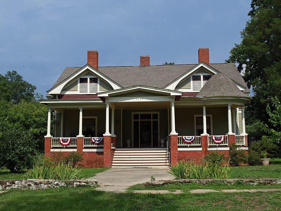
Photograph of Verbena
Photograph by Chris Pruitt, CC BY-SA 3.0. Via Wikimedia Commons.

Verbena

Listed on the National Register of Historic Places in 1976.

From the record

“Verbena, also known as Summerfield, is an unincorporated community in southeastern Chilton County, Alabama, United States. Named for the indigenous flower, Verbena developed into a popular resort location for the more affluent citizenry of Montgomery, the state's capital, during the yellow fever outbreaks of the late 19th and early 20th centuries.”

Wikipedia article Verbena, Alabama, CC BY-SA 4.0.

One of 3 National Register listings published here for Chilton County · listed in 1976 · category: District.

Sources: the Wikipedia article · the case file at the National Archives · the National Register database, National Park Service · the Wikipedia article

The listing

  • Address. US 31, Verbena, 36091
  • When was it listed? January 1976
  • Category. district
  • Census division. Verbena
  • National Register reference number. 76002238 - the number the National Park Service assigned this property when it was listed, and the key its nomination file is catalogued under at the National Archives.

Fires near this property

351 since 1994

Regional context, not property-specific evidence. The federal wildfire occurrence database lists 351 fires within 5 miles of Verbena between 1994 and 2019, burning about 1,832 acres in total. 5 started naturally. 74 were recorded as arson. Distance is straight-line from the map coordinates, so a fire counted here may appear on a neighbouring settlement's page as well.

Reported cause Fires
Debris and open burning154
Arson/incendiarism74
Missing data/not specified/undetermined60
Recreation and ceremony30
Equipment and vehicle use14
Smoking6
Misuse of fire by a minor6
Natural5
Railroad operations and maintenance1
Other causes1

The most recent of them, most recent first, with the day each was reported and the service that recorded it.

DateCause SizeReported by Name on the report
9 September 2007Missing data/not specified/undetermined1.0 acresAlabama Forestry Commissionnot named
8 September 1999Missing data/not specified/undeterminedunder an acreAlabama Forestry Commissionnot named
8 September 1995Recreation and ceremony1.0 acresAlabama Forestry Commissionnot named
7 September 2002Equipment and vehicle use5.0 acresAlabama Forestry Commissionnot named
6 September 2014Missing data/not specified/undetermined13 acresAlabama Forestry CommissionECR-20140906-001
5 September 1995Recreation and ceremony2.0 acresAlabama Forestry Commissionnot named
4 September 2010Debris and open burning1.0 acresAlabama Forestry Commissionnot named
4 September 1995Recreation and ceremony3.5 acresAlabama Forestry Commissionnot named

Every fire recorded in Chilton County

Mines and quarries near this property

10 of 29 shown

Regional context, not property-specific evidence. The federal mineral resources record lists 29 workings within 5 miles of Verbena: 15 unknowns, 11 past producers, 2 occurrences, 1 prospect. None of them still produces. What was taken out: Iron, Gold, Graphite, Mica. Distance is straight-line from the map coordinates, so a quarry counted here may appear on a neighbouring settlement's page as well.

Where SiteCommodity StatusRecorded
Bama Or Flaketown MineGraphite, MicaPast ProducerGraphite, Muscovite, Roscoelite
Bama Graphite MineGraphitePast Producer
Rippatoe Mine and PlacerGoldPast ProducerVein
Rippatoe PlacerGoldPast Producer1835
Rocky Creek PlacerGoldPast ProducerPlacer
Rocky Creek PlacerGoldPast Producer
Rocky Creek Placer MineGoldPast Producer1872
Unnamed Gold Placer ProspectGoldOccurrenceGold
William Howard PropertyGoldOccurrenceGold
William Howard ProspectGoldProspect

Every working recorded in Chilton County

Storms near this property

14 since 1996

Regional context, not property-specific evidence. The National Weather Service names Verbena, the town this property stands in, in 14 storm reports between 1996 and 2026: 8 thunderstorm wind, 4 hail, 1 heavy rain, 1 tornado. No death or injury is recorded in these reports. Each account below is quoted exactly as the forecast office filed it, from the NOAA Storm Events Database, and each date opens the federal record of that event.

WhenEvent Place namedHarm What the report says
March 2005Thunderstorm WindVerbena$45,000A severe thunderstorm caused extensive roof damage to two mobile homes in the Midway community just southeast of Verbena. One out-building suffered damage and several large tree limbs were snapped off.
March 2011Heavy RainVerbena$30,000Heavy rain reduced visibility and caused slick roadways along Interstate 65 near the Chilton and Autauga county line. As traffic moved slowly due to the thunderstorm and high volume of spring break travelers, a vehicle traveling south hydroplaned and crossed the median, hitting northbound traffic. The accident resulted in 5 fatalities (indirect) and at least 4 injuries (indirect). In addition, three vehicles were destroyed.
March 1996HailVerbena$15,000no account filed
February 2008Thunderstorm WindVerbena$5,000Several trees and power lines were blown down in the city of Verbena.
June 2007Thunderstorm WindVerbena$5,000Several large trees and power lines were blown down.
March 2026Thunderstorm WindVerbena-Trees were downed in the Verbena area, causing power outages.
July 2020Thunderstorm WindVerbena-Several trees upooted along County Road 59 in Verbena.
June 2020Thunderstorm WindVerbena-Several trees uprooted along Highway 22 near the city of Verbena.
March 2019Thunderstorm WindVerbena-Several trees uprooted around the town of Verbena.
June 2016Thunderstorm WindVerbena-A tree was uprooted across County Road 59. A motorcyclist drove into the tree and was injured.
March 2012Tornado (EF2)Verbena-A tornado touched down just west of Interstate 65, south of exit 200 in Chilton County. Here, a few trees were snapped or uprooted. It quickly strengthened and grew to its maximum width of 700 yards as it crossed County Road 502. The tornado moved east across US Highway 31 near the intersection with County Road 526, 1.5 miles south of Verbena. The tornado intensified to 125 mph and destroyed one home and caused significant damage to another, as well as mowing down hundreds of trees around the two homes. The tornado continued to snap and uproot trees as it neared County Road 524, where it also destroyed two single-wide manufactured homes and caused significant damage to two homes. A total of thirteen homes were damage or destroyed in and around Verbena. The tornado then crossed into Coosa County, before it eventually lifted.
March 2013HailVerbena-no account filed
May 2011HailVerbena-no account filed
March 2011HailVerbena-no account filed

Every storm recorded in Chilton County

Map coverage status

No historic map-sheet match is published for this property yet. That does not mean no map exists. This record needs a coordinate-quality review before it can be joined to a sheet boundary. Browse the county's mapped places while that work is pending.

Sources for this property

National Archives recordThe nomination case file for reference 76002238 in Record Group 79.
Wikipedia articleCommunity-written account of this property, licensed CC BY-SA.
Chilton CountyAll 3 listed properties in this county.

Provenance

  • Listing record. National Park Service National Register of Historic Places, listed-properties dataset, current to 2026-05-22.
  • Map join. Address geocoded through the United States Census geocoder, then tested against the published boundary of every sheet in the USGS Historical Topographic Map Collection.
  • How this page is made. Listing fields come from federal records; map-sheet coverage is a labelled coordinate-to-boundary calculation, not a source-field claim.
  • Wildfire. Short, Karen C. 2022. Spatial wildfire occurrence data for the United States, 1992-2020 [FPA_FOD_20221014]. 6th Edition. Fort Collins, CO: Forest Service Research Data Archive. https://doi.org/10.2737/RDS-2013-0009.6 Collected with United States Government funding and usable without additional permissions or fees.
  • Mines and quarries. USGS Mineral Resources Data System (MRDS) https://mrdata.usgs.gov/mrds/ A work of the United States government, no copyright under 17 U.S.C. 105.
  • Storms. NOAA National Centers for Environmental Information, Storm Events Database https://www.ncei.noaa.gov/stormevents/ A work of the United States government, no copyright under 17 U.S.C. 105. Narratives are quoted verbatim from the National Weather Service report and are not edited or summarised.