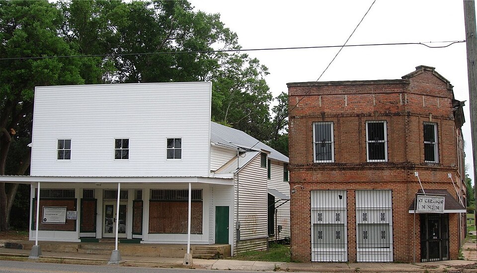
Listed on the National Register of Historic Places in 1990.
From the record
“Grand Bay Historic District is a historic district in Grand Bay, Alabama. Listed on the National Register of Historic Places in 1990, the district comprises twelve acres and the three remaining original buildings from Grand Bay's central business district.”
Wikipedia article Grand Bay Historic District, CC BY-SA 4.0.
One of 146 National Register listings published here for Mobile County · listed in 1990 · category: District.
National Register reference number.90000918- the number the National Park Service assigned this property when it was listed, and the key its nomination file is catalogued under at the National Archives.
Fires near this property
646 since 1992
Regional context, not property-specific
evidence. The
federal wildfire occurrence database
lists 646 fires within 5 miles of Grand Bay Historic District
between 1992 and 2019, burning about 10,592 acres in total. 4 started naturally. 304 were recorded as arson.
Distance is straight-line from the map coordinates, so a fire counted
here may appear on a neighbouring settlement's page as well.
Reported cause
Fires
Arson/incendiarism
304
Debris and open burning
185
Missing data/not specified/undetermined
106
Recreation and ceremony
30
Equipment and vehicle use
12
Natural
4
Railroad operations and maintenance
3
Smoking
2
The most recent of
them, most recent first, with the day each was reported and the service
that recorded it.
Regional context, not property-specific
evidence. The federal mineral resources record lists
11 workings within 5 miles of Grand Bay Historic District: 7 producers, 4 past producers.
7 still produce. What was taken out: Sand and Gravel, Construction, Silica, Clay, Sand and Gravel, Construction, Clay. Distance is straight-line from the
map coordinates, so a quarry counted here may appear on a neighbouring
settlement's page as well.
Regional context, not property-specific
evidence. The National Weather Service names
Grand Bay, the town this property stands in, in 39 storm reports between 1995 and 2026: 13 thunderstorm wind, 11 flash flood, 8 hail, 4 tornado.
No death or injury is recorded in these reports. Each account below is quoted exactly as the forecast office
filed it, from the NOAA Storm Events Database, and each date
opens the federal record of that event.
High winds from a thunderstorm blew the roofs off of two portable buildings at a school in Grand Bay. Trees were also blown down and nickel size hail was also reported in the area. No students were in the portables when their roofs were blown off.
Four to six inches of rain fell in a short time over central and southern Mobile County. This resulted in flooding across numerous areas and numerous road closures. Grand Bay Fire Department conducted a water rescue at Highway 188 and Ferland Road. Another water rescue was conducted on Golf Way Drive in Prichard. Water was reported in a home on Kent Street in Mobile.
Winds estimated at 80 mph destroyed a barn and downed multiple trees and power lines. A double wide mobile home was also blown off its foundation along Fred Freedland Road.
Available high resolution satellite imagery was able to reveal an|EF0 tornado tracked north of Interstate 10 near Grand Bay. The|tornado began north of Pascagoula Road solely in forest causing|minor tree damage. While there is a gap in visible damage on|satellite imagery, radar tornado debris signature persists east|connecting with another small corridor of tree damage near Ramsey|Road and Boe Road. This is where the end point of the tornado is|estimated as any visible damage associated with the radar|signature disappears after reaching I-10.
An EF1 tornado began south of Dees in Mobile County west of Grand|Bay Wilmer Road. A radar indicated tornado debris signature began|in the adjacent forest, tracking northeast across Grand Bay Wilmer|Road. As it crossed the road, multiple pine trees were snapped|midway up the trunk along with a couple smaller pine tree snaps|near the base of the trunk. One tree had fallen across power|lines and brought them down. The smaller snaps to the south were|likely thanks to the supercells RFD with the primary damage being|near the bridge here. The tornado weakened somewhat as it|continued northeast across Balford and Ballard Roads. Here some|metal roofing material was tossed to the west with multiple large|tree limbs broken. The tornado then continued northeast across Ben|Hamilton Road impacting a pond north of the road. This pond had|multiple trees that were uprooted with a tree snapped low. The|tornado went through a majority of forest and open fields between|Ben Hamilton Road and Dawes Road, additionally impacting a|neighborhood with most notable damage being along the intersection|of Southern Oaks Trail and Dawes Road. Damage was mostly|comprised of large tree limbs broken off and minor roofing damage|to homes. There were additional reports of sheds flipped|over/moved and a piece of metal breaking a window of one of the|homes.
An NWS damage survey found a couple of snapped large branches with a few snapped or uprooted softwood trees. A couple out buildings with most of their roofs removed and a manufactured home with minor roof damage. Winds were estimated to be 75 mph and time was estimated by radar.
The tornado touched down just south of County Road 33 along Fred Freeland Road. The tornado widened to about 80 yards wide, destroying a horse barn, moving a double wide mobile home off its foundation, snapping several pine trees and bringing down power lines.
No historic map-sheet match is published
for this property yet. That does not mean no map exists. This record needs
a coordinate-quality review before it can be joined to a sheet boundary.
Browse the county's mapped places while that work is
pending.
Listed places nearby
1 within 8 miles
Other National Register properties close
enough to walk or drive between, ordered by distance from this one. Both
positions come from the same geocoding pass that matched these properties
to their map sheets.
Listing record. National Park Service National Register of Historic Places, listed-properties dataset, current to 2026-05-22.
Map join. Address geocoded through the United States Census geocoder, then tested against the published boundary of every sheet in the USGS Historical Topographic Map Collection.
How this page is made. Listing fields come from federal records; map-sheet coverage is a labelled coordinate-to-boundary calculation, not a source-field claim.
Wildfire. Short, Karen C. 2022. Spatial wildfire occurrence data for the United States, 1992-2020 [FPA_FOD_20221014]. 6th Edition. Fort Collins, CO: Forest Service Research Data Archive. https://doi.org/10.2737/RDS-2013-0009.6 Collected with United States Government funding and usable without additional permissions or fees.
Mines and quarries. USGS Mineral Resources Data System (MRDS) https://mrdata.usgs.gov/mrds/ A work of the United States government, no copyright under 17 U.S.C. 105.
Storms. NOAA National Centers for Environmental Information, Storm Events Database https://www.ncei.noaa.gov/stormevents/ A work of the United States government, no copyright under 17 U.S.C. 105. Narratives are quoted verbatim from the National Weather Service report and are not edited or summarised.
 Block