
BlockBefore
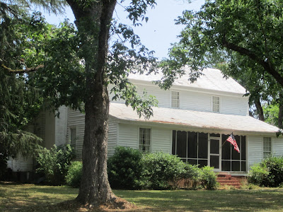
Photograph of Lassiter House
Photograph by WillyT006, CC BY-SA 3.0. Via Wikimedia Commons.

Lassiter House

Built in 1825. Listed on the National Register of Historic Places in 1997.

From the record

“The Lassiter House, also known as the Treadwell House, is a historic residence in Autaugaville, Alabama, United States. The house was built in 1825 in the vernacular I-house style.”

Wikipedia article Lassiter House (Autaugaville, Alabama), CC BY-SA 4.0.

One of 5 National Register listings published here for Autauga County · listed in 1997 · category: Building · built in 1825.

Sources: the Wikipedia article · the case file at the National Archives · the National Register database, National Park Service · the Wikipedia article

The listing

  • What is counted as historic. The nomination lists 3 buildingss as contributing to the listing.
  • Address. Antauga County 15. 0.5 mi. N of jct. of AL 14 and Co. Rd 15, Autaugaville, 36003
  • When was it listed? July 1997
  • Category. building
  • Census division. Autaugaville
  • When was it built? 1825
  • National Register reference number. 97000651 - the number the National Park Service assigned this property when it was listed, and the key its nomination file is catalogued under at the National Archives.

Fires near this property

96 since 1994

Regional context, not property-specific evidence. The federal wildfire occurrence database lists 96 fires within 5 miles of Lassiter House between 1994 and 2020, burning about 567 acres in total. 1 started naturally. 14 were recorded as arson. Distance is straight-line from the map coordinates, so a fire counted here may appear on a neighbouring settlement's page as well.

Reported cause Fires
Debris and open burning48
Missing data/not specified/undetermined16
Arson/incendiarism14
Recreation and ceremony11
Equipment and vehicle use4
Smoking2
Natural1

The most recent of them, most recent first, with the day each was reported and the service that recorded it.

DateCause SizeReported by Name on the report
3 September 2019Debris and open burning15 acresAlabama Forestry Commission20190903-2
26 September 2000Debris and open burning5.0 acresAlabama Forestry Commissionnot named
17 September 1997Debris and open burningunder an acreAlabama Forestry Commissionnot named
10 September 2019Debris and open burning15 acresAlabama Forestry Commission20190910-5
10 September 2005Debris and open burning14 acresAlabama Forestry Commissionnot named
6 August 2000Arson/incendiarism3.2 acresAlabama Forestry Commissionnot named
29 August 2014Missing data/not specified/undetermined28 acresAlabama Forestry CommissionECR-20140829-002
29 August 1995Debris and open burning2.0 acresAlabama Forestry Commissionnot named

Every fire recorded in Autauga County

Mines and quarries near this property

1 within 5 miles

Regional context, not property-specific evidence. The federal mineral resources record lists 1 working within 5 miles of Lassiter House: 1 producer. All of them still produce. What was taken out: Sand and Gravel, Construction. Distance is straight-line from the map coordinates, so a quarry counted here may appear on a neighbouring settlement's page as well.

Where SiteCommodity StatusRecorded
Tyler PlantSand and Gravel, ConstructionProducerUnconsolidated Sediments

Every working recorded in Autauga County

Storms near this property

23 since 1997

Regional context, not property-specific evidence. The National Weather Service names Autaugaville, the town this property stands in, in 23 storm reports between 1997 and 2025: 15 thunderstorm wind, 4 tornado, 3 hail, 1 flash flood. The reports record 3 injuries. Each account below is quoted exactly as the forecast office filed it, from the NOAA Storm Events Database, and each date opens the federal record of that event.

WhenEvent Place namedHarm What the report says
March 1999Thunderstorm WindAutaugaville2 hurt, $150,000One of two thunderstorms that moved diagonally across Autauga County caused trees to be knocked down from the southwest corner of the county to the northeast corner of the county. The most significant damage occurred at a small community called Fig Tree on the east side of CR 1 in western Autauga County. At least four mobile homes were totally destroyed and three other mobile homes sustained minor damage. One mobilehome was rolled over a van destroying the vehicle. One building suffered major damage while two other houses sustained minor damage. Two minor injuries were reported.
November 2004Tornado (F2)Autaugaville1 hurt, $900,000no account filed
November 2005Tornado (F0)Autaugaville$34,000National Weather Service meteorologists surveyed the damage that affected the Whitewater Community and areas near Autaugaville. It has been determined that the damage was the result of a tornado. The tornado has been rated an F0 on the Fujita Damage Intensity Scale. The tornado first touched down approximately 3.2 miles west of Autaugaville near the intersection of County Road 45 and County Road 78. The tornado tracked in a northeastward direction and crossed State Highway 14, County Road 19, and County Road 165. The tornado lifted just east of the Whitewater Community, north of County Road 165. The tornado damage path was approximately 5.4 miles long and 150 yards wide at its widest point. The tornado was on the ground from approximately 641 PM CST to 651 PM CST. Along the damage path, numerous large trees were snapped off and uprooted. A garage attached to a mobile home was blown away. At another location, vinyl siding was blown off a house and a fence was blown down. One shed was totally destroyed. Some tin was peeled off a steel building.Begin: 32.4378/86.7092 End: 32.4700/86.6244
July 2005Tornado (F1)Autaugaville$14,000National Weather Service meteorologists surveyed the damage between Independence and Autaugaville and determined the damage was the result of a tornado. The tornado touched down at approximately 127 PM CDT along County Road 13, 5 miles north of Autaugaville. Several trees were snapped off or blown down along the short path. One out-building sustained damage. The tornado damage path was 1/4 of a mile long and 30 yards wide at its widest point. This tornado was spawned during Tropical Storm Cindy.
August 2000Thunderstorm WindAutaugaville$8,000A few trees were knocked down in and around the city of Autaugaville. One tree fell onto a home causing damage.
February 1997Thunderstorm WindAutaugaville$8,000no account filed
September 2011Thunderstorm WindAutaugaville$5,000Trees were reported down along County Road 13, causing damage to the awning of a travel trailer, a flat bed auto trailer, and a fence.
July 1999Thunderstorm WindAutaugaville$5,000Trees and power lines were blown down in Autaugaville. Pea size hail was also reported.
July 2002Thunderstorm WindAutaugaville$4,000Several trees were blown down on CR 45 and on CR 19 near Autaugaville.
April 2011Thunderstorm WindAutaugaville$2,000Trees were blown down along County Road 21 near Swift Creek.
October 2007Thunderstorm WindAutaugaville$2,000Numerous 2 to 3 inch tree limbs were blown down across some roads. School opening in Autaugaville was delayed until the roads could be cleared.
April 2000Thunderstorm WindAutaugaville$2,000A few trees were blown down just west of Autaugaville.
July 2008Thunderstorm WindAutaugaville$1,000Several trees and power lines were blown down on Key Road, north of Autaugaville.
April 2009Thunderstorm WindAutaugaville$500A power line was blown down on AL-14, on the west side of Autaugaville.
February 2025Thunderstorm WindAutaugaville-A 70 mph wind gust was measured on a personal weather station in Autaugaville. A social media photo was received showing a tree down on a fence in Autaugaville as well.
March 2019Thunderstorm WindAutaugaville-Several trees uprooted along County Road 45.
October 2017Tornado (EF1)Autaugaville-NWS meteorologists surveyed damage in far southern Autauga County and determined that the damage was consistent with an EF1 tornado. The tornado began just north of the Alabama River in private farmland and moved northwest across County Road 19 where it uprooted trees and snapped a few tree trunks. The tornado continued northwest crossing County Road 17 near the intersection of County Road 74 where several trees were uprooted. The tornado then continued northwest where it uprooted trees along a portion of Dutch Bend Road and snapped some tree trunks along County Road 33. The tornado moved further northwest where it crossed Alabama Highway 14 where it uprooted trees near the roadway. The tornado likely lifted in a forested area to the north of Alabama Highway 14.
June 2017Flash FloodAutaugaville-Heavy rainfall during the early morning hours produced rainfall amounts of 3-5 inches in a time span of two to three hours. Widespread flooding was reported over the eastern half of Autauga County. Up to four feet of water was reported at the intersection of Highway 82 and County Road 21. Flooding washed out portions of Manning Road. Vehicle with occupants became trapped by the rising water on County Road 59.
July 2016Thunderstorm WindAutaugaville-Several trees uprooted along County Road 19.
July 2013Thunderstorm WindAutaugaville-Several trees were reported down along Highway 14 and County Road 45, just west of Autaugaville.
March 2005HailAutaugaville-Nickel size hail was reported near Autaugaville.
April 2002HailAutaugaville-Dime size hail fell just south of Autaugaville.
May 2012HailAutaugaville-no account filed

Every storm recorded in Autauga County

Map coverage status

No historic map-sheet match is published for this property yet. That does not mean no map exists. This record needs a coordinate-quality review before it can be joined to a sheet boundary. Browse the county's mapped places while that work is pending.

Sources for this property

National Archives recordThe nomination case file for reference 97000651 in Record Group 79.
Wikipedia articleCommunity-written account of this property, licensed CC BY-SA.
Autauga CountyAll 5 listed properties in this county.

Provenance

  • Listing record. National Park Service National Register of Historic Places, listed-properties dataset, current to 2026-05-22.
  • Map join. Address geocoded through the United States Census geocoder, then tested against the published boundary of every sheet in the USGS Historical Topographic Map Collection.
  • How this page is made. Listing fields come from federal records; map-sheet coverage is a labelled coordinate-to-boundary calculation, not a source-field claim.
  • Wildfire. Short, Karen C. 2022. Spatial wildfire occurrence data for the United States, 1992-2020 [FPA_FOD_20221014]. 6th Edition. Fort Collins, CO: Forest Service Research Data Archive. https://doi.org/10.2737/RDS-2013-0009.6 Collected with United States Government funding and usable without additional permissions or fees.
  • Mines and quarries. USGS Mineral Resources Data System (MRDS) https://mrdata.usgs.gov/mrds/ A work of the United States government, no copyright under 17 U.S.C. 105.
  • Storms. NOAA National Centers for Environmental Information, Storm Events Database https://www.ncei.noaa.gov/stormevents/ A work of the United States government, no copyright under 17 U.S.C. 105. Narratives are quoted verbatim from the National Weather Service report and are not edited or summarised.