 Block
From the record
9 National Register listings published here.
Sources: the National Register database, National Park Service
46 topographic sheets cover 27 settlements here, and 9 properties are on the National Register of Historic Places.
9 National Register listings published here.
Sources: the National Register database, National Park Service
Every property in this county listed on the National Register of Historic Places, with the year it was listed and the federal nomination document.
| Photograph | Property | Type | Listed | Reference |
|---|---|---|---|---|
 | Calhoun County Courthouse | building | 1976 | 76000390 |
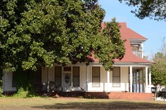 | Dunn House | building | 1976 | 76000391 |
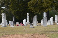 | Hampton Cemetery | site | 2009 | 09000340 |
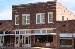 | Hampton Masonic Lodge Building | building | 2008 | 08000433 |
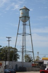 | Hampton Waterworks | structure | 2006 | 06000909 |
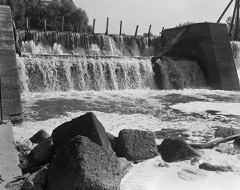 | Ouachita River Lock and Dam No. 8 | structure | 1983 | 83003458 |
| Shumaker Naval Ammunition Depot (NAD) 500-Man Barracks | building | 2018 | 100002448 | |
| Shumaker Naval Ammunition Depot (NAD) Administration Building | building | 2018 | 100002449 | |
| State Highway 274 Bridge | structure | 1995 | 95000610 |
Every wildfire the federal occurrence database records inside this county: 596 of them, burning about 9,853 acres. 58 started naturally and 95 were recorded as arson. Each settlement page carries the fires within five miles of it.
| Reported cause | Fires |
|---|---|
| Missing data/not specified/undetermined | 206 |
| Debris and open burning | 130 |
| Arson/incendiarism | 95 |
| Equipment and vehicle use | 77 |
| Natural | 58 |
| Recreation and ceremony | 11 |
| Misuse of fire by a minor | 10 |
| Smoking | 5 |
| Railroad operations and maintenance | 4 |
The five largest, by the area the report gives. None of them was recorded as arson.
| Date | Cause | Size | Reported by | Name on the report |
|---|---|---|---|---|
| 2 September 2005 | Missing data/not specified/undetermined | 3,070 acres | Arkansas Forestry Commission | GRIMMETT |
| 13 October 2011 | Missing data/not specified/undetermined | 490 acres | Arkansas Forestry Commission | LLOYD CREEK |
| 2 September 2005 | Debris and open burning | 307 acres | Arkansas Forestry Commission | not named |
| 31 March 2003 | Natural | 238 acres | Arkansas Forestry Commission | not named |
| 15 October 2015 | Missing data/not specified/undetermined | 202 acres | Arkansas Forestry Commission | not named |
| 22 August 2005 | Natural | 200 acres | Arkansas Forestry Commission | WOODBERRY |
| 18 August 2015 | Debris and open burning | 186 acres | Arkansas Forestry Commission | not named |
| 4 July 2011 | Natural | 160 acres | Arkansas Forestry Commission | ATHANT BRANCH |
Every settlement page carries the fires within five miles of it - see the settlement index below.
The NOAA Storm Events Database holds 280 reports for this county, causing no deaths, 1 injury and about $10,980,500 in recorded property damage. Each settlement page carries the reports that name it.
| Kind of event | Reports |
|---|---|
| Thunderstorm Wind | 96 |
| Hail | 76 |
| Flood | 51 |
| Flash Flood | 33 |
| Tornado | 20 |
| Heavy Rain | 3 |
| Lightning | 1 |
The most serious of them, by death, then injury, then recorded damage. The accounts are quoted exactly as the forecast office filed them.
| When | Event | Place named | Harm | What the report says |
|---|---|---|---|---|
| April 1979 | Tornado (F3) | not stated | 1 hurt, $2,500,000 | no account filed |
| October 2009 | Tornado (EF2) | East Camden | $1,750,000 | The tornado began in a wooded area of the Highland Industrial Park and then tore through the Arkansas Fire Training Academy. At the academy, the Apparatus Building was heavily damaged, walls were blown out of the Smoke Building, a large part of the roof was torn off the Administration and Classroom Building, and vehicles belonging to the students were tossed around and overturned. About 60 staff members and students were in the Administration and Classroom Building, but they were aware of the tornado warning that was in effect and had taken shelter in small, interior rooms. There were no injuries. Trees, power lines, and power poles were blown down. The tornado then continued into the Ouachita County portion of the Highland Industrial Park. |
| May 2009 | Flood | Delhi | $600,000 | The stage at Camden remained above flood stage from the 4th of May into June. The crest of the river was the highest since flooding in 1990. Numerous cabins along the high banks of the river were impacted by inundation or isolation. County roads also suffered damage. |
| May 2011 | Flood | Thornton | $500,000 | Flooding in Calhoun County continued into June. |
| September 2008 | Flash Flood | Locust Bayou | $500,000 | Flooding occurred on County Road 29. |
| September 2008 | Flash Flood | Hampton | $500,000 | There was flooding in Hampton. An assisted living center had to be evacuated. Arkansas Highway 203 along with other roads were impassable due to flooding. U.S Highway 167 at mile marker 9 was flooded. Three people had to be evacuated from their residences in Hampton. |
| September 2008 | Flash Flood | East Camden | $500,000 | Flooding occurred on County Road 95. |
| May 2007 | Lightning | Woodberry | $500,000 | Lightning struck an electrical substation and set fire to a large transformer. Power was initially knocked out to a large part of Calhoun County, but some of the power was restored quickly. The most prolonged power outages occurred in the areas around Highland Industrial Park and Locust Bayou. |
| October 2009 | Thunderstorm Wind | Hampton | $450,000 | Roofs of several buildings were damaged on the campus of the Hampton schools. Some of the debris was thrown onto a nearby football field. A flagpole was bent and part of the scoreboard damaged at the field. Due to roof damage at the high school gym, water poured down on the basketball court. Numerous large trees and power lines were blown down, and a few of the trees landed on structures. Trees were also blown down along U.S. Highway 278 east of Hampton. Numerous power lines were blown down and some power poles were broken. |
| October 2009 | Tornado (EF1) | East Camden | $300,000 | This tornado exited the Ouachita County portion of East Camden and moved into the Calhoun County portion of the town and the Highland Industrial Park. At Southern Arkansas University Tech, a number of buildings suffered roof damage, and several 18-wheeler trailers were blown over. Many trees were blown down, some of which fell on vehicles parked at the university.. The tornado then exited Calhoun County and once again moved into Ouachita County. |
| December 2009 | Flood | Thornton | $250,000 | Flash flooding, which developed on the morning of the 24th, became widespread areal flooding later on the 24th and continued into Christmas morning. |
| December 2009 | Flash Flood | Thornton | $250,000 | Widespread heavy rain resulted in flash flooding on the 24th. |
| April 2008 | Thunderstorm Wind | Thornton | $250,000 | Trees and power lines were blown down, and there was structural damage to homes. |
| December 1978 | Tornado (F1) | not stated | $250,000 | no account filed |
| October 2009 | Flash Flood | Thornton | $200,000 | Numerous county roads were damaged by flash flooding. |
| September 1996 | Tornado (F1) | Locust Bayou | $200,000 | no account filed |
| September 2009 | Flash Flood | Delhi | $150,000 | U.S. Highway 278 between Locust Bayou and Hampton was closed due to flooding. Water was over several county roads south of Hampton. The sheriff's office evacuated an elderly couple from their home at Locust Bayou. The water was 4 feet deep in the house, causing a freezer to float from one room to another. Two other homes on U.S. Highway 278 west of Hampton had water in them. |
| June 2019 | Thunderstorm Wind | Harrell | $100,000 | Numerous trees were down across the area. A damage survey confirmed 80 to 85 mph straight line winds at Harrell. Numerous trees were downed or snapped, with some trees on houses. Several carports were damaged. A brick wall at a car wash perpendicular to the wind was blown down. |
| December 2015 | Tornado (EF1) | East Camden | $100,000 | Several pine trees were either uprooted or snapped off near the Highland Industrial Park. Part of a flat roof was blown off a couple industrial buildings. Several empty rail cars were blown over to the west. This tornado then exited Calhoun County and continued into Ouachita County southwest of Beardon. |
| March 2012 | Flood | Thornton | $100,000 | Numerous county roads were flooded, as were sections of Arkansas 274 near Tinsman and Arkansas 203 near Hampton. The county judge declared a disaster due to the flooding. |
| April 2011 | Flood | Thornton | $100,000 | Widespread areal flooding occurred. |
| September 2009 | Flood | East Camden | $100,000 | Heavy rainfall in middle September pushed the Ouachita River at Camden above flood stage. Some private roads, county roads, and one state highway were inundated. |
| July 2011 | Thunderstorm Wind | Woodberry | $75,000 | A mobile home plus four barns and outbuildings were damaged. Some trees and power poles were blown down. |
| December 2015 | Tornado (EF1) | Artesian | $50,000 | Several pine trees were snapped and uprooted. A couple sheds were destroyed, with roof damage to a home. One of the pine trees fell on two cars, crushing them. |
| April 2014 | Thunderstorm Wind | Elberta | $50,000 | Trees were blown down. Power was knocked out to the entire county, due to power lines having been blown down. |
| May 2013 | Flash Flood | Delhi | $50,000 | Heavy rain caused flash flooding in Hampton. Water entered some apartments and a number of streets were flooded. CoCoRaHs observers reported 4.72 inches of rain 3.7 miles south of Hampton and 4.57 inches 6.8 miles southeast of Hampton. |
| September 2009 | Flood | Delhi | $50,000 | Heavy rainfall during the middle of September pushed the Ouachita River above the flood elevation at Thatcher Lock and Dam. Timber roads and access to oil rigs were flooded. |
| October 2009 | Flash Flood | Moro Farm | $50,000 | Flooding occurred on several streets in Hampton as well as on U.S. Highways 167 and 278. Flood water entered a couple of apartments, necessitating evacuations during the morning. By evening, nine additional homes were sandbagged, and Arkansas Highways 203 and 172 were blocked by flooding. |
| September 2008 | Flash Flood | Woodberry | $50,000 | Flooding occurred on some of the highways around the Highland Industrial Park. |
| September 2008 | Flash Flood | Tinsman | $50,000 | Flooding occurred on Arkansas Highway 274 between Tinsman and Fordyce. |
| November 1994 | Thunderstorm Wind | Hampton | $50,000 | Thunderstorm winds downed power lines and blew awnings off several buildings. |
| April 2014 | Thunderstorm Wind | Hampton | $25,000 | Many trees and power lines were blown down. |
| April 2014 | Thunderstorm Wind | Summerville | $25,000 | Numerous trees were blown down. |
| January 2012 | Tornado (EF1) | Little Bay | $25,000 | An EF1 tornado tracked through timber lands in Calhoun County. Most of the damage consisted of trees being blown down or having their tops taken off. The tornado exited Calhoun County north-northwest of Thornton and entered Dallas County west-southwest of Beech Grove. |
| April 2008 | Flood | Delhi | $25,000 | Minor to moderate flooding occurred along the lower Ouachita River for most or all of the month of April. Damages were limited to scour on county roads. High water cut off access to timber and oil wells. |
| May 2010 | Thunderstorm Wind | Thornton | $20,000 | Trees and power lines were blown down in Thornton. |
| July 2011 | Thunderstorm Wind | Unco | $15,000 | The over-roof of a mobile home was blown off. Trees were blown down in the area. |
| October 2010 | Thunderstorm Wind | Ebenezer | $15,000 | Several trees were blown down along Arkansas Highway 8. One of the trees fell on a power line. |
| May 2009 | Thunderstorm Wind | Harlow | $15,000 | Numerous large trees were down outside of Thornton along U.S. Highway 79. |
| July 2009 | Thunderstorm Wind | Hampton | $15,000 | Trees and power lines were down in Hampton. |
| July 2009 | Thunderstorm Wind | Ebenezer | $15,000 | Trees and power lines were down at Tri-County Lake. |
| March 2012 | Flood | Hopeville | $10,000 | Heavy rain flooded several county roads in Calhoun County. |
| April 2011 | Thunderstorm Wind | Hampton | $10,000 | Several trees were blown down. |
| August 2010 | Thunderstorm Wind | Hampton | $10,000 | Trees and a utility pole were blown down. |
| June 2009 | Thunderstorm Wind | Harrell | $10,000 | Trees were down across the area. |
| July 2009 | Thunderstorm Wind | Tinsman | $10,000 | Trees were down in Tinsman. |
| October 2009 | Thunderstorm Wind | Thornton | $10,000 | Numerous trees were down. |
| October 2009 | Tornado (EF1) | Locust Bayou | $10,000 | This tornado exited Ouachita County northeast of Frenchport and entered Calhoun County about 6 2/3 miles southwest of Locust Bayou. In Calhoun County, the tornado traveled through wetlands, doing nothing more than knocking down trees. The tornado exited the county about 4 1/3 miles west of Locust Bayou, traveling back into Ouachita County about 2 1/4 miles south-southwest of Lakeside. |
| March 1997 | Flash Flood | Hampton | $10,000 | no account filed |
| July 2011 | Thunderstorm Wind | Unco | $7,000 | Trees and power lines were blown down along Calhoun County Road 26. |
| March 2023 | Thunderstorm Wind | Thornton | $5,000 | Minor roof damage was reported along with trees down along Hwy. 167 south of Thornton. |
| May 2019 | Thunderstorm Wind | Chambersville | $5,000 | A tree was blown down onto a house. |
| April 2011 | Thunderstorm Wind | Woodberry | $5,000 | Some trees were blown down. |
| June 2011 | Flood | Artesian | $5,000 | Areal flooding in southern Calhoun County diminished after the Ouachita River receded. |
| May 2010 | Tornado (EF0) | Artesian | $5,000 | An EF0 tornado blew down tree limbs on timber lands. The tornado exited Calhoun County southeast of Artesian and moved into Bradley County north-northwest of Moro Bay. |
| May 2009 | Flash Flood | Woodberry | $5,000 | Flooding occurred on County Road 95 and Woodberry Road. |
| October 2009 | Thunderstorm Wind | Elberta | $5,000 | Strong thunderstorm winds blew down some large trees. |
| October 2009 | Thunderstorm Wind | Woodberry | $5,000 | Strong thunderstorm winds blew down some large trees. |
| October 2009 | Thunderstorm Wind | Levit | $5,000 | Trees were blown down. |
| October 1993 | Thunderstorm Wind | Hampton | $5,000 | Thunderstorm winds downed some trees. |
The Survey's mineral resources record lists 106 workings inside this county. 8 still produce and 98 are closed or unrecorded. Each settlement page carries the workings within five miles of it.
| Commodity | Workings |
|---|---|
| Sand and Gravel, Construction | 106 |
The least common of them first, because a county's hundredth gravel pit says nothing its first ten did not.
| Where | Site | Commodity | Status | Recorded |
|---|---|---|---|---|
| Calhoun Cnty Pit | Sand and Gravel, Construction | Producer | ||
| Cram No 2 Plant | Sand and Gravel, Construction | Producer | ||
| Hampton Pit & Plant | Sand and Gravel, Construction | Producer | ||
| Harrell Pit & Plant | Sand and Gravel, Construction | Producer | ||
| Holly Springs Pit & Plant | Sand and Gravel, Construction | Producer | ||
| J B Jones Pit | Sand and Gravel, Construction | Past Producer | ||
| Keith Williams | Sand and Gravel, Construction | Unknown | ||
| Loveless Mine | Sand and Gravel, Construction | Producer | ||
| Quachita Aggregate | Sand and Gravel, Construction | Past Producer | ||
| Ritchey Mine | Sand and Gravel, Construction | Producer | ||
| St Francis Material Co Inc | Sand and Gravel, Construction | Unknown | 1890, 1937 | |
| Unknown | Sand and Gravel, Construction | Unknown | ||
| Unknown Gravel Pit | Sand and Gravel, Construction | Unknown | ||
| Unknown Gravel Pit | Sand and Gravel, Construction | Unknown | ||
| Unknown Gravel Pit | Sand and Gravel, Construction | Unknown | ||
| Unknown Gravel Pit | Sand and Gravel, Construction | Unknown | ||
| Unknown Gravel Pit | Sand and Gravel, Construction | Unknown | ||
| Unknown Gravel Pit | Sand and Gravel, Construction | Unknown | ||
| Unknown Gravel Pit | Sand and Gravel, Construction | Unknown | ||
| Unknown Gravel Pit | Sand and Gravel, Construction | Unknown | ||
| Unknown Gravel Pit | Sand and Gravel, Construction | Unknown | ||
| Unknown Gravel Pit | Sand and Gravel, Construction | Unknown | ||
| Unknown Gravel Pit | Sand and Gravel, Construction | Unknown | ||
| Unknown Gravel Pit | Sand and Gravel, Construction | Unknown | ||
| Unknown Gravel Pit | Sand and Gravel, Construction | Unknown | ||
| Unknown Gravel Pit | Sand and Gravel, Construction | Unknown | ||
| Unknown Gravel Pit | Sand and Gravel, Construction | Unknown | ||
| Unknown Gravel Pit | Sand and Gravel, Construction | Producer | ||
| Unknown Gravel Pit | Sand and Gravel, Construction | Unknown | ||
| Unknown Gravel Pit | Sand and Gravel, Construction | Unknown | ||
| Unknown Gravel Pit | Sand and Gravel, Construction | Unknown | ||
| Unknown Gravel Pit | Sand and Gravel, Construction | Unknown | ||
| Unknown Gravel Pit | Sand and Gravel, Construction | Unknown | ||
| Unknown Gravel Pit | Sand and Gravel, Construction | Unknown | ||
| Unknown Gravel Pit | Sand and Gravel, Construction | Unknown | ||
| Unknown Gravel Pit | Sand and Gravel, Construction | Unknown | ||
| Unknown Gravel Pit | Sand and Gravel, Construction | Unknown | ||
| Unknown Gravel Pit | Sand and Gravel, Construction | Unknown | ||
| Unknown Gravel Pit | Sand and Gravel, Construction | Unknown | ||
| Unknown Gravel Pit | Sand and Gravel, Construction | Unknown | ||
| Unknown Gravel Pit | Sand and Gravel, Construction | Unknown | ||
| Unknown Gravel Pit | Sand and Gravel, Construction | Unknown | ||
| Unknown Gravel Pit | Sand and Gravel, Construction | Unknown | ||
| Unknown Gravel Pit | Sand and Gravel, Construction | Unknown | ||
| Unknown Gravel Pit | Sand and Gravel, Construction | Unknown | ||
| Unknown Gravel Pit | Sand and Gravel, Construction | Unknown | ||
| Unknown Gravel Pit | Sand and Gravel, Construction | Unknown | ||
| Unknown Gravel Pit | Sand and Gravel, Construction | Unknown | ||
| Unknown Gravel Pit | Sand and Gravel, Construction | Unknown | ||
| Unknown Gravel Pit | Sand and Gravel, Construction | Unknown | ||
| Unknown Gravel Pit | Sand and Gravel, Construction | Unknown | ||
| Unknown Gravel Pit | Sand and Gravel, Construction | Unknown | ||
| Unknown Gravel Pit | Sand and Gravel, Construction | Unknown | ||
| Unknown Gravel Pit | Sand and Gravel, Construction | Unknown | ||
| Unknown Gravel Pit | Sand and Gravel, Construction | Unknown | ||
| Unknown Gravel Pit | Sand and Gravel, Construction | Unknown | ||
| Unknown Gravel Pit | Sand and Gravel, Construction | Unknown | ||
| Unknown Gravel Pit | Sand and Gravel, Construction | Unknown | ||
| Unknown Gravel Pit | Sand and Gravel, Construction | Unknown | ||
| Unknown Gravel Pit | Sand and Gravel, Construction | Unknown | ||
| Unknown Gravel Pit | Sand and Gravel, Construction | Unknown | ||
| Unknown Gravel Pit | Sand and Gravel, Construction | Unknown | ||
| Unknown Gravel Pit | Sand and Gravel, Construction | Unknown | ||
| Unknown Gravel Pit | Sand and Gravel, Construction | Unknown | ||
| Unknown Gravel Pit | Sand and Gravel, Construction | Unknown | ||
| Unknown Gravel Pit | Sand and Gravel, Construction | Unknown | ||
| Unknown Gravel Pit | Sand and Gravel, Construction | Unknown | ||
| Unknown Gravel Pit | Sand and Gravel, Construction | Unknown | ||
| Unknown Gravel Pit | Sand and Gravel, Construction | Unknown | ||
| Unknown Gravel Pit | Sand and Gravel, Construction | Unknown | ||
| Unknown Gravel Pit | Sand and Gravel, Construction | Unknown | ||
| Unknown Gravel Pit | Sand and Gravel, Construction | Unknown | ||
| Unknown Gravel Pit | Sand and Gravel, Construction | Unknown | ||
| Unknown Gravel Pit | Sand and Gravel, Construction | Unknown | ||
| Unknown Gravel Pit | Sand and Gravel, Construction | Unknown | ||
| Unknown Gravel Pit | Sand and Gravel, Construction | Unknown | ||
| Unknown Gravel Pit | Sand and Gravel, Construction | Unknown | ||
| Unknown Gravel Pit | Sand and Gravel, Construction | Unknown | ||
| Unknown Gravel Pit | Sand and Gravel, Construction | Unknown | ||
| Unknown Gravel Pit | Sand and Gravel, Construction | Unknown | ||
| Unknown Gravel Pit | Sand and Gravel, Construction | Unknown | ||
| Unknown Gravel Pit | Sand and Gravel, Construction | Unknown | ||
| Unknown Gravel Pit | Sand and Gravel, Construction | Unknown | ||
| Unknown Gravel Pit | Sand and Gravel, Construction | Unknown | ||
| Unknown Gravel Pit | Sand and Gravel, Construction | Unknown | ||
| Unknown Gravel Pit | Sand and Gravel, Construction | Unknown | ||
| Unknown Gravel Pit | Sand and Gravel, Construction | Unknown | ||
| Unknown Gravel Pits | Sand and Gravel, Construction | Unknown | ||
| Unknown Gravel Pits | Sand and Gravel, Construction | Unknown | ||
| Unknown Gravel Pits | Sand and Gravel, Construction | Unknown | ||
| Unknown Gravel Pits | Sand and Gravel, Construction | Unknown | ||
| Unknown Gravel Pits | Sand and Gravel, Construction | Unknown | ||
| Unknown Gravel Pits | Sand and Gravel, Construction | Unknown | ||
| Unknown Gravel Pits 2 | Sand and Gravel, Construction | Unknown | ||
| Unknown Gravel Pits 2 | Sand and Gravel, Construction | Unknown | ||
| Unknown Gravel Pits 2 | Sand and Gravel, Construction | Unknown | ||
| Unknown Gravel Pits 2 | Sand and Gravel, Construction | Unknown | ||
| Unknown Gravel Pits 2 | Sand and Gravel, Construction | Unknown | ||
| Unknown Gravel Pits 3 | Sand and Gravel, Construction | Unknown | ||
| Unknown Gravel Pits 4 | Sand and Gravel, Construction | Unknown | ||
| Unknown Gravel Pits 4 | Sand and Gravel, Construction | Unknown | ||
| Unknown Gravel Pits 5 | Sand and Gravel, Construction | Unknown | ||
| Unknown Gravel Pits 7 | Sand and Gravel, Construction | Unknown | ||
| Unknown Sand Pit | Sand and Gravel, Construction | Unknown | ||
| Unknown Sand Pit | Sand and Gravel, Construction | Unknown | ||
| Unknown Sandpit | Sand and Gravel, Construction | Unknown |
Named settlements recorded in the Geographic Names Information System, each with the topographic sheets covering it. Villages, hamlets and abandoned places alike. Each is shown with the nearest named watercourse or landform and the survey quadrangle it falls on.
Township 2 · 71766 · On Little Champagnolle Creek · Chambersville quadrangle
12 sheets, 1953 to 1989
No longer a settlement
Township 2 · 71766 · On Lost Creek · Chambersville quadrangle
12 sheets, 1953 to 1989
No longer a settlement
Township 7 · On Dogwood Creek · East Camden quadrangle
16 sheets, 1903 to 1989
No longer a settlement
Township 3 · On Anna Branch · Tinsman quadrangle
12 sheets, 1953 to 1989
No longer a settlement
Township 3 · 71742 · On Dry Creek · Tinsman quadrangle
12 sheets, 1953 to 1989
No longer a settlement
Township 6 · 71744 · On Blackwater Creek · Snow Hill quadrangle
16 sheets, 1953 to 1989
No longer a settlement
The vanished settlements of Calhoun County: the places named above that are no longer on the map.