 Block
From the record
16 National Register listings published here.
Sources: the National Register database, National Park Service
54 topographic sheets cover 56 settlements here, and 16 properties are on the National Register of Historic Places.
16 National Register listings published here.
Sources: the National Register database, National Park Service
Every property in this county listed on the National Register of Historic Places, with the year it was listed and the federal nomination document.
| Photograph | Property | Type | Listed | Reference |
|---|---|---|---|---|
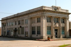 | Arkansas Bank & Trust Company | building | 1986 | 86002859 |
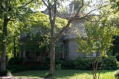 | Empie-Van Dyke House | building | 1977 | 77000257 |
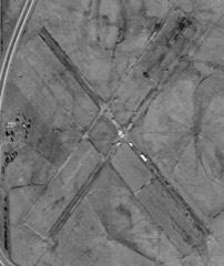 | Erwin Auxiliary Army Airfield | structure | 2008 | 08000954 |
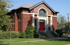 | First Presbyterian Church | building | 1982 | 82000837 |
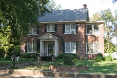 | Gregg House | building | 1982 | 82000838 |
 | Jackson County Courthouse | building | 1976 | 76000421 |
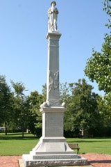 | Jackson Guards Memorial | object | 1996 | 96000465 |
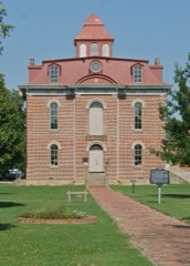 | Jacksonport State Park | district | 1970 | 70000121 |
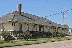 | Missouri-Pacific Depot-Newport | building | 1992 | 92000619 |
| New Home School Building | building | 1992 | 92001357 | |
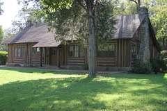 | Newport American Legion Community Hut | building | 1992 | 92001672 |
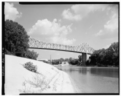 | Newport Bridge | structure | 1990 | 90000503 |
 | Newport Junior & Senior High School | building | 1982 | 82000839 |
 | Tuckerman Water Tower | structure | 2007 | 07000443 |
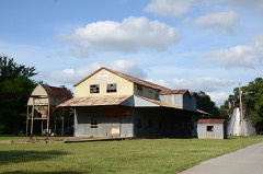 | Weldon Gin Company Historic District | district | 2008 | 08000487 |
Every wildfire the federal occurrence database records inside this county: 126 of them, burning about 5,240 acres. 1 started naturally and 59 were recorded as arson. Each settlement page carries the fires within five miles of it.
| Reported cause | Fires |
|---|---|
| Arson/incendiarism | 59 |
| Debris and open burning | 37 |
| Missing data/not specified/undetermined | 22 |
| Smoking | 4 |
| Equipment and vehicle use | 2 |
| Natural | 1 |
| Railroad operations and maintenance | 1 |
The five largest, by the area the report gives. 6 of them were set deliberately.
| Date | Cause | Size | Reported by | Name on the report |
|---|---|---|---|---|
| 22 December 2005 | Arson/incendiarism | 776 acres | Arkansas Forestry Commission | not named |
| 2 July 2006 | Arson/incendiarism | 441 acres | Arkansas Forestry Commission | not named |
| 1 March 2008 | Debris and open burning | 282 acres | Arkansas Forestry Commission | JACKSON |
| 7 February 2000 | Arson/incendiarism | 275 acres | Arkansas Forestry Commission | not named |
| 25 October 1999 | Arson/incendiarism | 255 acres | Arkansas Forestry Commission | not named |
| 6 August 1999 | Arson/incendiarism | 140 acres | Arkansas Forestry Commission | not named |
| 10 November 2010 | Missing data/not specified/undetermined | 125 acres | Cache River National Wildlife Refuge | BEEDEVILLE FIRE |
| 5 April 2009 | Arson/incendiarism | 90 acres | Arkansas Forestry Commission | not named |
Every settlement page carries the fires within five miles of it - see the settlement index below.
The NOAA Storm Events Database holds 501 reports for this county, causing 6 deaths, 108 injuries and about $78,608,280 in recorded property damage. Each settlement page carries the reports that name it.
| Kind of event | Reports |
|---|---|
| Thunderstorm Wind | 216 |
| Hail | 114 |
| Tornado | 61 |
| Flash Flood | 48 |
| Flood | 43 |
| Heavy Rain | 11 |
| Funnel Cloud | 5 |
| Lightning | 3 |
The most serious of them, by death, then injury, then recorded damage. The accounts are quoted exactly as the forecast office filed them.
| When | Event | Place named | Harm | What the report says |
|---|---|---|---|---|
| March 1997 | Tornado (F2) | Denmark | 2 killed, 30 hurt, $10,000,000 | no account filed |
| March 1997 | Tornado (F2) | Jacksonport | 1 killed, 30 hurt, $25,000,000 | no account filed |
| May 1968 | Tornado (F4) | not stated | 1 killed, 11 hurt, $25,000 | no account filed |
| April 1950 | Tornado (F3) | not stated | 1 killed, 8 hurt, $2,500 | no account filed |
| February 2019 | Flood | Elgin | 1 killed | A 76 year old man passed away after driving into a flooded road along Highway 37 driving from Jackson County towards Independence County. It appeared as though the driver went around four barricades in place for flooding along the highway near Elgin before driving into flood waters. Flood waters were over the highway due to flooding along the Black River at the time of the incident. |
| May 1984 | Tornado (F2) | not stated | 8 hurt, $2,500,000 | no account filed |
| May 1973 | Tornado (F4) | not stated | 7 hurt, $25,000 | no account filed |
| March 1952 | Tornado (F3) | not stated | 6 hurt, $2,500 | no account filed |
| January 1999 | Tornado (F1) | Newport | 3 hurt | no account filed |
| November 1973 | Tornado (F2) | not stated | 1 hurt, $250,000 | no account filed |
| January 1999 | Tornado (F1) | Tuckerman | 1 hurt | no account filed |
| August 1986 | Thunderstorm Wind | not stated | 1 hurt | no account filed |
| November 1983 | Thunderstorm Wind | not stated | 1 hurt | no account filed |
| November 1983 | Thunderstorm Wind | not stated | 1 hurt | no account filed |
| March 1984 | Tornado (F4) | not stated | $25,000,000 | no account filed |
| March 2008 | Flood | Reamey | $5,000,000 | Heavy rain caused the White River at Newport to crest above major flood level and at the same stage as in December, 1982. Approximately 45 homes in Newport were damaged due to the rising water. The Jacksonport State Park was submerged by water from the river. The camping area, pavilion, playground and bathrooms were flooded. In Jackson County, 53 homes and 47 county roads confirmed damage. Arkansas Highways 14 and 69 were flooded. Agricultural damages were also noted with pastures and winter wheat losses. |
| December 1982 | Tornado (F3) | not stated | $2,500,000 | no account filed |
| May 2011 | Flood | Swifton | $1,500,000 | Parts of Arkansas Highways 14, 18, 37, 42, 69, 69S, 224, 226, and 384 were closed due to flooding. Jacksonport and areas to the north of town were evacuated; Jacksonport State Park was closed. Flooding in Jackson County continued into June. |
| April 2010 | Tornado (EF3) | Weldon | $1,000,000 | This was the fifth of five tornadoes spawned by the same supercell thunderstorm. This tornado passed through the south side of Shoffner. A church was destroyed and a power substation was damaged. A hangar at a flying service was destroyed and an aircraft used for agricultural application was damaged. A mobile home was overturned and destroyed. Significant roof damage occurred to homes. A grain elevator was badly damaged. An irrigation pivot was overturned. Outbuildings were destroyed or damaged. Trees were blown down. |
| June 2009 | Thunderstorm Wind | Beedeville | $600,000 | A building belonging to an agricultural flying service was destroyed, as was the crop dusting plane inside it. |
| June 1994 | Thunderstorm Wind | Amagon | $500,000 | Thunderstorm winds damaged some grain bins and farm buildings. Several trees and antennas were also blown down. |
| June 2014 | Flash Flood | Elgin | $275,000 | Beedeville measured 5.20 inches of rain. Arkansas 367 and numerous county roads flooded, as did farm fields. The soybean crop was damaged and rice levees were washed out. |
| June 2014 | Thunderstorm Wind | Swifton | $250,000 | Damaging thunderstorm winds blew through Swifton. At the fire department administrative building (old City Hall), a bay door blew in. Once the wind was inside the building, it blew out much of the rear of the building and took off a large part of the roof. Rain poured in, leaving more than an inch of water on the floor of the offices. Across the street, a large tree fell on a garage. Nearby, a huge tree fell into a house, causing large limbs to jut through the ceilings of several rooms. |
| December 2009 | Flash Flood | Centerville | $250,000 | Widespread heavy rain led to the development of flash flooding early on the morning of the 24th. |
| December 2009 | Flood | Centerville | $250,000 | Flash flooding, which developed early on the morning of the 24th, became widespread areal flooding later in the morning on the 24th and continued through Christmas. Arkansas Highways closed due to high water included: 14 just off U.S. Highway 67 near Newport to Waldenburg, 226 from U.S. Highway 67 to the Jackson/Craighead County line, 224 in the Tuckerman and Swifton areas, 18 Spur to Grubbs, 17 from Weldon to Tupelo, 42 south of Beedeville, and 18. Jackson County Roads flooded included 42, 43, 81, 211, and 315. |
| December 1982 | Tornado (F2) | not stated | $250,000 | no account filed |
| November 1973 | Tornado (F2) | not stated | $250,000 | no account filed |
| May 1955 | Tornado (F2) | not stated | $250,000 | no account filed |
| March 2020 | Tornado (EF1) | Algoa | $200,000 | Law enforcement reported several power lines down and a few roofs missing from homes between Algoa and Amagon. Farm machinery was tossed into a field. |
| June 2009 | Thunderstorm Wind | Newport | $150,000 | A number of trees were blown down. Some of the trees landed on houses. |
| March 2008 | Flash Flood | Milltown | $150,000 | Sand bags were placed on and around the rail line near Jacksonport. The Missouri/North Arkansas Railroad line was shut down all the way to Cotter. Arkansas Highways 69, 226, 37, 14 and 224 were closed due to high water. |
| April 2008 | Flood | Jacksonport | $150,000 | After only a day below flood stage, the White River at the Newport gage rose again to major flood level by the 12th of the month, and remained above the major flood level for more than three days. The river fell below flood stage on the 22nd of the month. The April crest of 33.16 feet was the third highest since the flood control reservoirs were completed in the middle of the twentieth century. Damages were limited to whatever repairs had been made since the March crest. |
| December 2007 | Lightning | Diaz | $150,000 | Lightning struck a house in the eastern part of Diaz. Apparently, the resulting fire smoldered for about two hours before the fire was noticed. Visibility was poor at the time, due to fog and continuous rain. By the time the fire alarm was turned in, flames were shooting well above the roof. The house was destroyed, and an elderly couple who lived there lost their lives. The fatalities were a male, 73, and a female, 70. A camping trailer and an all-terrain vehicle, which were parked near the house, were also damaged. |
| April 2011 | Flood | Swifton | $125,000 | Widespread areal flooding occurred. A portion of Arkansas Highway 14 was closed from the afternoon of the 26th through the end of the month. Part of Arkansas Highway 224 was closed from the morning of the 27th through the end of the month. Parts of Arkansas Highways 37, 69, and 226 were closed from the morning of the 28th through the end of the month. |
| October 2009 | Flash Flood | Centerville | $110,000 | Flash flooding caused damage to numerous county roads. |
| December 2021 | Tornado (EF1) | Diaz | $100,000 | This tornado started just west of the White River Apartments causing roof damage to some of those apartment buildings. Damage was also noted to buildings at the George Kell Park, along with several trees uprooted along this path. This tornado lifted shortly before Hwy. 367. |
| March 2017 | Tornado (EF1) | Diaz | $100,000 | The survey team found numerous trees and power poles downed or snapped and structural damage to a few homes. One home had the back of a garage blown out and part of the roof removed in the back. A storage building was hit broadside and thrown. On US 67/167, road signs were obliterated. South of the tornado, there was random damage to structures, including doors blown in at a fire house. This was caused by straight-line winds. Farther east toward the Newport Airport, there was extensive damage at a prison. A mobile home was rolled, and a couple of barns had mostly roof damage. Straight-line winds were estimated at 80-90 mph. Wind gusts reached 66 mph at the Newport Airport. The survey team would like to thank Don Ivie, Jackson County Emergency Manager, for his valuable assistance during this survey. |
| June 2009 | Thunderstorm Wind | Weldon | $100,000 | An irrigation pivot was overturned. |
| April 2014 | Tornado (EF1) | Denmark | $70,000 | The tornado exited White County 1.1 miles east-southeast of Midway and entered Jackson County 2.3 miles north of Denmark. In Jackson County, two outbuildings were destroyed, there was roof damage to a house, and a barn was blown down. Trees and power lines were also blown down. |
| April 2011 | Thunderstorm Wind | Denmark | $70,000 | Many trees were blown down, one of which fell on a house, and another of which crushed a shed. The roof was blown off a barn, a livestock trailer was rolled against a pick-up truck, a pontoon boat was overturned, and a travel trailer was moved. Another travel trailer being used as a residence was overturned and destroyed. |
| January 2007 | Flash Flood | Grubbs | $70,000 | Cache River near Grubbs and Amagon overflowed its banks. Many area roads were closed due to flooding. |
| December 2021 | Tornado (EF1) | Mc Fadden | $50,000 | This brief tornado started north of the intersection of County Road 169 and Hwy. 37, moving northeast along the west side of Hwy. 37 for about a half mile before lifting south of County Road 141. Some trees were uprooted and a couple of travel trailers were blown over. Several residences on Highway 37 were damaged. |
| March 2017 | Thunderstorm Wind | Newport Muni Arpt | $50,000 | Law enforcement reported several trailers have been flipped over. |
| March 2017 | Thunderstorm Wind | Newport Muni Arpt | $50,000 | Extensive damage was found near the Newport airport at a prison. Some structural damage was noted, including a rolled over mobile home and roof damage at a couple of barns. Wind gusts reached at least 90 mph. |
| August 2012 | Lightning | Vance | $50,000 | Lightning struck an electric substation, knocking out power to more than 3000 customers. |
| September 2009 | Flash Flood | Centerville | $50,000 | Most county roads were under water, but none were closed. |
| April 2008 | Flash Flood | Newport Muni Arpt | $50,000 | Flooding occurred in downtown Newport. |
| June 1994 | Thunderstorm Wind | Swifton | $50,000 | Thunderstorm winds downed some trees and power lines. |
| July 1994 | Thunderstorm Wind | Auvergne | $50,000 | Portions of roofs were blown off several buildings. |
| August 1993 | Thunderstorm Wind | Weldon | $50,000 | Thunderstorm winds blew the roof off a few houses and several trees were also knocked down. |
| October 2014 | Thunderstorm Wind | Newport | $40,000 | A truck carrying chicken parts was blown over, spilling part of its load into the roadside ditch. |
| June 2014 | Tornado (EF1) | Mc Fadden | $40,000 | An EF1 tornado badly damaged an old aircraft hangar, and destroyed a 40 ft. by 50 ft. shop building, scattering debris out across farm fields for more than a quarter mile. Several power poles were blown down. |
| September 2012 | Thunderstorm Wind | Newport | $40,000 | Numerous trees and power lines were blown down. |
| August 2011 | Thunderstorm Wind | Possum Grape | $40,000 | A tree fell on a business and power poles were blown down. |
| April 2018 | Thunderstorm Wind | Swifton | $30,000 | A roof was removed from a home in Swifton. |
| March 2017 | Tornado (EF1) | Grand Glaise | $30,000 | The survey team found extensive tree damage, with numerous trees downed or snapped. In one location, the trees were very large, with one tree crushing a tractor. Several homes had mostly roof damage, with one roof mostly removed. The survey team would like to thank Don Ivie, Jackson County Emergency Manager, for his valuable assistance during this survey. |
| July 2014 | Thunderstorm Wind | Swifton | $25,000 | A roof was blown off a night club. |
| April 2010 | Thunderstorm Wind | Swifton | $25,000 | A hay barn was blown down. |
| June 2009 | Thunderstorm Wind | Tupelo | $25,000 | Trees and many large limbs were blown down. |
| April 2009 | Thunderstorm Wind | Grubbs | $25,000 | Three homes had roof damage and tree limbs and power lines were down on the southeast side of Grubbs. |
The Survey's mineral resources record lists 10 workings inside this county. 6 still produce and 4 are closed or unrecorded. Each settlement page carries the workings within five miles of it.
| Commodity | Workings |
|---|---|
| Sand and Gravel, Construction | 9 |
| Sand and Gravel, Construction, Stone, Crushed/Broken | 1 |
The least common of them first, because a county's hundredth gravel pit says nothing its first ten did not.
| Where | Site | Commodity | Status | Recorded |
|---|---|---|---|---|
| Newport #5 & #7 | Sand and Gravel, Construction, Stone, Crushed/Broken | Past Producer | ||
| County Operators | Sand and Gravel, Construction | Producer | ||
| Midstream Dredge & Plant No 6 | Sand and Gravel, Construction | Producer | ||
| Mobley Construction Co | Sand and Gravel, Construction | Past Producer | ||
| Newport Dredge & Plant | Sand and Gravel, Construction | Producer | ||
| Newport Plt | Sand and Gravel, Construction | Past Producer | ||
| River S&G Co | Sand and Gravel, Construction | Producer | ||
| River Sand & Gravel Dredge | Sand and Gravel, Construction | Producer | ||
| Unk Gravel Pits 2 | Sand and Gravel, Construction | Past Producer | ||
| Viking Pit | Sand and Gravel, Construction | Producer |
Named settlements recorded in the Geographic Names Information System, each with the topographic sheets covering it. Villages, hamlets and abandoned places alike. Each is shown with the nearest named watercourse or landform and the survey quadrangle it falls on.
Barren township · 72020 · On Bullock Branch · Velvet Ridge quadrangle
9 sheets, 1935 to 1986
No longer a settlement
Cow Lake township · 72347 · Beedeville quadrangle
10 sheets, 1940 to 1986
No longer a settlement
Cow Lake township · 72112 · Beedeville quadrangle
10 sheets, 1940 to 1986
No longer a settlement
Bryan township · 72112 · On Deadman Slough · Augusta NE quadrangle
11 sheets, 1935 to 1986
Jefferson township · 72112 · On Black River · Jacksonport quadrangle
13 sheets, 1935 to 1986
Jefferson township · 72112 · Near Howard Mound · Jacksonport quadrangle
13 sheets, 1935 to 1986
Grubbs township · 72112 · Amagon quadrangle
10 sheets, 1935 to 1986
No longer a settlement
The vanished settlements of Jackson County: the places named above that are no longer on the map.