
BlockBefore
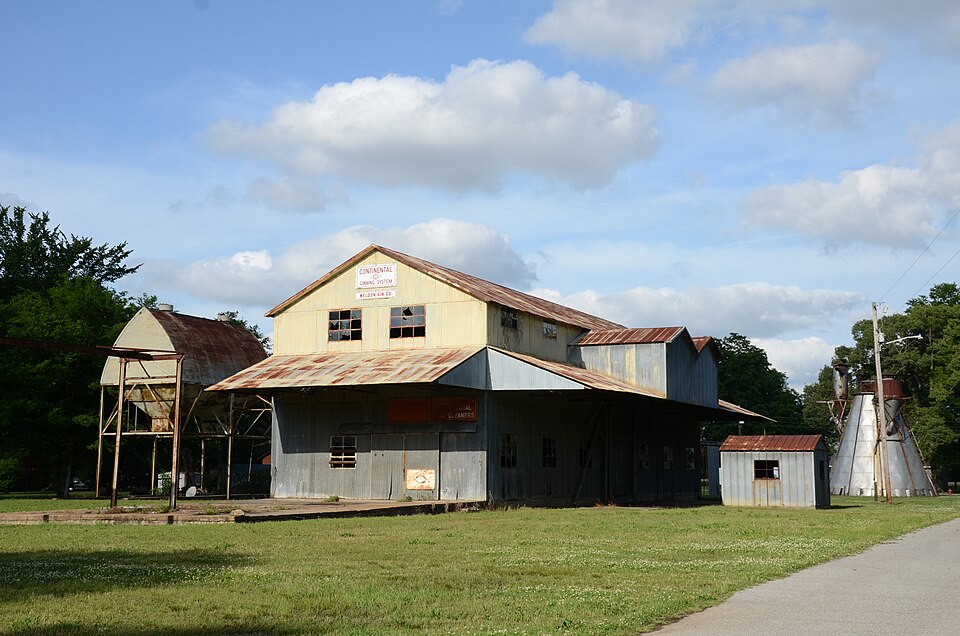
Photograph of Weldon Gin Company Historic District
Photograph by Valis55, CC BY-SA 3.0. Via Wikimedia Commons.

Weldon Gin Company Historic District

Listed on the National Register of Historic Places in 2008.

From the record

“The Weldon Gin Company Historic District encompasses a historic cotton gin complex in Weldon, Arkansas. With a history dating to 1833, the Weldon Gin Company was long a staple of the local economy.”

Wikipedia article Weldon Gin Company Historic District, CC BY-SA 4.0.

One of 16 National Register listings published here for Jackson County · listed in 2008 · category: District.

Sources: the Wikipedia article · the National Register database, National Park Service

The listing

  • What is counted as historic. The nomination lists 3 buildingss, 3 structuress as contributing to the listing.
  • Address. NE corner of jct. of Washington St. & AR 17, Weldon, 72112
  • When was it listed? June 2008
  • Category. district
  • Also known as. Cotton and Rice Farm History and Architecture in the Arkansas Delta MPS
  • Township. Breckenridge township
  • National Register reference number. 08000487 - assigned by the National Park Service when the property was listed.

Fires near this property

11 since 1992

Regional context, not property-specific evidence. The federal wildfire occurrence database lists 11 fires within 5 miles of Weldon Gin Company Historic District between 1992 and 2015, burning about 163 acres in total. None started naturally. 1 was recorded as arson. Distance is straight-line from the map coordinates, so a fire counted here may appear on a neighbouring settlement's page as well.

Reported cause Fires
Debris and open burning9
Arson/incendiarism1
Smoking1

The most recent of them, most recent first, with the day each was reported and the service that recorded it.

DateCause SizeReported by Name on the report
10 September 1999Debris and open burning8.0 acresArkansas Forestry Commissionnot named
25 August 1999Debris and open burning2.0 acresArkansas Forestry Commissionnot named
1 July 1992Debris and open burning6.0 acresCentral Arkansas Refuges ComplexBLACK
7 June 2010Debris and open burning5.0 acresArkansas Forestry Commissionnot named
15 April 1996Arson/incendiarism14 acresCentral Arkansas Refuges ComplexALLEN
2 March 1993Smokingunder an acreCentral Arkansas Refuges ComplexHWY 145
12 March 2005Debris and open burning1.0 acresArkansas Forestry Commissionnot named
1 March 2006Debris and open burning4.0 acresArkansas Forestry Commissionnot named

Every fire recorded in Jackson County

Storms near this property

12 since 1993

Regional context, not property-specific evidence. The National Weather Service names Weldon, the town this property stands in, in 12 storm reports between 1993 and 2024: 8 thunderstorm wind, 3 tornado, 1 flash flood. No death or injury is recorded in these reports. Each account below is quoted exactly as the forecast office filed it, from the NOAA Storm Events Database, and each date opens the federal record of that event.

WhenEvent Place namedHarm What the report says
April 2010Tornado (EF3)Weldon$1,000,000This was the fifth of five tornadoes spawned by the same supercell thunderstorm. This tornado passed through the south side of Shoffner. A church was destroyed and a power substation was damaged. A hangar at a flying service was destroyed and an aircraft used for agricultural application was damaged. A mobile home was overturned and destroyed. Significant roof damage occurred to homes. A grain elevator was badly damaged. An irrigation pivot was overturned. Outbuildings were destroyed or damaged. Trees were blown down.
June 2009Thunderstorm WindWeldon$100,000An irrigation pivot was overturned.
August 1993Thunderstorm WindWeldon$50,000Thunderstorm winds blew the roof off a few houses and several trees were also knocked down.
June 2009Thunderstorm WindWeldon$15,000Trees and large limbs were blown down.
July 2010Flash FloodWeldon$2,000Minor flooding occurred.
April 2024Thunderstorm WindWeldon-Several trees and power lines were blown down in the town of Weldon resulting in a lack of power to the entire town.
June 2009Thunderstorm WindWeldon-Large limbs were blown down.
May 2008Thunderstorm WindWeldon-Large limbs were down.
May 2003Tornado (F1)Weldon-A weak tornado touched down in southern Jackson County just north of Weldon. Seven large wooden structures which hold up power lines were blown down. Nearby, nine power poles were snapped off and some trees were knocked down. A farm shed had its metal roof blown off. The tornado quickly dissipated about 1.5 miles northeast of Weldon.
May 2003Tornado (F1)Weldon-A weak tornado moved from White County into Jackson County about 3.5 miles west of Weldon. The tornado remained on the ground for about 14 miles before dissipating about 1 mile northeast of Amagon. Most of the damage consisted of a number of downed trees, large limbs being twisted off trees and tops being blown out of trees. Some residences sustained roof damage, mainly from falling trees and shingles torn off.
March 2006Thunderstorm WindWeldon-no account filed
December 1996Thunderstorm WindWeldon-no account filed

Every storm recorded in Jackson County

Map coverage status

No historic map-sheet match is published for this property yet. That does not mean no map exists. This record needs a coordinate-quality review before it can be joined to a sheet boundary. Browse the county's mapped places while that work is pending.

Sources for this property

National Archives recordThe nomination case file for reference 08000487 in Record Group 79.
Wikipedia articleCommunity-written account of this property, licensed CC BY-SA.
Jackson CountyAll 16 listed properties in this county.

Provenance

  • Listing record. National Park Service National Register of Historic Places, listed-properties dataset, current to 2026-05-22.
  • Map join. Address geocoded through the United States Census geocoder, then tested against the published boundary of every sheet in the USGS Historical Topographic Map Collection.
  • How this page is made. Listing fields come from federal records; map-sheet coverage is a labelled coordinate-to-boundary calculation, not a source-field claim.
  • Wildfire. Short, Karen C. 2022. Spatial wildfire occurrence data for the United States, 1992-2020 [FPA_FOD_20221014]. 6th Edition. Fort Collins, CO: Forest Service Research Data Archive. https://doi.org/10.2737/RDS-2013-0009.6 Collected with United States Government funding and usable without additional permissions or fees.
  • Storms. NOAA National Centers for Environmental Information, Storm Events Database https://www.ncei.noaa.gov/stormevents/ A work of the United States government, no copyright under 17 U.S.C. 105. Narratives are quoted verbatim from the National Weather Service report and are not edited or summarised.