 Block
From the record
12 National Register listings published here.
Sources: the National Register database, National Park Service
64 topographic sheets cover 51 settlements here, and 12 properties are on the National Register of Historic Places.
12 National Register listings published here.
Sources: the National Register database, National Park Service
Every property in this county listed on the National Register of Historic Places, with the year it was listed and the federal nomination document.
| Photograph | Property | Type | Listed | Reference |
|---|---|---|---|---|
 | Bank of Kingston | building | 1982 | 82002122 |
 | Bunch Store | building | 1999 | 99001350 |
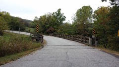 | Cannon Creek Bridge | structure | 2004 | 04001033 |
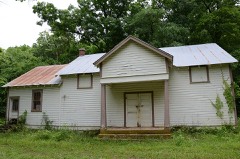 | Enterprise School | building | 1992 | 92001192 |
| Orval E. Faubus House | building | 2019 | 100004443 | |
 | Huntsville Commercial Historic District | district | 2008 | 08000705 |
 | Madison County Courthouse | building | 1993 | 93001253 |
 | Pettigrew School | building | 1995 | 95000272 |
 | St. Paul School Building | building | 2006 | 06000416 |
 | War Eagle Creek Bridge | structure | 2008 | 07001430 |
| Wharton Creek Roadside Park | site | 2024 | 100010310 | |
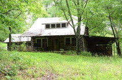 | Williams House and Associated Farmstead | building | 2001 | 01000508 |
Every wildfire the federal occurrence database records inside this county: 268 of them, burning about 9,952 acres. 4 started naturally and 97 were recorded as arson. Each settlement page carries the fires within five miles of it.
| Reported cause | Fires |
|---|---|
| Arson/incendiarism | 97 |
| Missing data/not specified/undetermined | 87 |
| Debris and open burning | 52 |
| Equipment and vehicle use | 18 |
| Smoking | 5 |
| Natural | 4 |
| Misuse of fire by a minor | 2 |
| Recreation and ceremony | 2 |
| Power generation/transmission/distribution | 1 |
The five largest, by the area the report gives. Four of them were set deliberately.
| Date | Cause | Size | Reported by | Name on the report |
|---|---|---|---|---|
| 1 January 2006 | Missing data/not specified/undetermined | 1,000 acres | Oklahoma Division of Forestry | STROUD FIRE |
| 14 April 2003 | Missing data/not specified/undetermined | 843 acres | Arkansas Forestry Commission | not named |
| 22 March 2011 | Arson/incendiarism | 426 acres | Arkansas Forestry Commission | WOLF PEN |
| 27 March 2001 | Missing data/not specified/undetermined | 320 acres | Arkansas Forestry Commission | not named |
| 8 December 2008 | Arson/incendiarism | 288 acres | Arkansas Forestry Commission | not named |
| 10 April 2006 | Arson/incendiarism | 275 acres | Arkansas Forestry Commission | LIACH |
| 15 March 2018 | Missing data/not specified/undetermined | 250 acres | Arkansas Forestry Commission | not named |
| 20 January 2006 | Arson/incendiarism | 211 acres | Arkansas Forestry Commission | not named |
Every settlement page carries the fires within five miles of it - see the settlement index below.
The NOAA Storm Events Database holds 503 reports for this county, causing 9 deaths, 9 injuries and about $5,590,850 in recorded property damage. Each settlement page carries the reports that name it.
| Kind of event | Reports |
|---|---|
| Thunderstorm Wind | 212 |
| Hail | 202 |
| Flash Flood | 60 |
| Tornado | 28 |
| Lightning | 1 |
The most serious of them, by death, then injury, then recorded damage. The accounts are quoted exactly as the forecast office filed them.
| When | Event | Place named | Harm | What the report says |
|---|---|---|---|---|
| April 1996 | Tornado (F3) | St Paul | 2 killed, 6 hurt, $1,000,000 | no account filed |
| April 2004 | Flash Flood | Countywide | 2 killed, $200,000 | Several rounds of thunderstorms during the April 20s caused periodic flash flooding over much of Madison County. For the 72 hour period ending 7 am cdt April 24, Huntsville and St. Paul received 6.57 and 6.35 inches of rain respectively. Numerous roads were flooded and as much as $100,000 damage was done to them. Some homes in the Witter area were also flooded. However; the most major event occured around 645 am cdt on the 24th. A pickup truck containing 4 occupants stalled in high water over a bridge crossing Hock Creek 5 miles southwest of Huntsville. A 3 year old girl and a 2 year old boy were swept away in the flood waters and died. The woman driving the truck and another child escaped.On April 25th, the governor of Arkansas declared Madison county a disaster area. |
| April 2017 | Flash Flood | Forum | 2 killed | War Eagle Creek flooded portions of several roads north and east of Hindsville. A woman drove a vehicle into flood water and was swept downstream. She exited the vehicle and survived, but her two young children drowned. |
| April 2011 | Flash Flood | Witter | 2 killed | Heavy rainfall resulted in portions of Highway 23 becoming flooded south of Witter. A vehicle driven into the flood waters was washed off the road and the two elderly occupants both drown in the flood water. |
| January 1998 | Flash Flood | South Portion | 1 killed, $10,000 | The Madison County sheriff died when his patrol car was swept off of a low-water bridge over the White River on County Road 112 near St. Paul around 7:00 am. The river was swollen by heavy rains during the night. The 24-hour rainfall ending at 7 AM for St. Paul was 3.39 inches. |
| April 1996 | Thunderstorm Wind | Venus | 2 hurt, $70,000 | no account filed |
| May 1960 | Tornado (F2) | not stated | 1 hurt, $25,000 | no account filed |
| August 2013 | Flash Flood | Spoke Plant | $450,000 | Numerous roads were flooded and closed across the southern portion of the county. Significant damage to roads and bridges occurred due to the flooding. |
| April 2016 | Tornado (EF1) | Wesley | $250,000 | This tornado destroyed several outbuildings, damaged homes, snapped or uprooted numerous trees, and blew down power poles. Based on this damage, maximum estimated wind in the tornado was 100 to 110 mph. |
| March 2015 | Tornado (EF1) | Clifty | $250,000 | A tornado developed northwest of Clifty, where it severely damaged three chicken houses and damaged a home. It moved east-northeast damaging an additional chicken house, several homes, and snapped trees along Highway 127. The tornado then damaged a mobile home, another chicken house, and trees as it crossed Highway 23. Based on this damage, maximum estimated wind in the tornado was 95 to 105 mph. |
| January 2013 | Tornado (EF1) | Rockhouse | $250,000 | A tornado destroyed several barns and outbuildings, damaged a couple homes, and snapped or uprooted numerous trees, and blew down power poles. Several cows were killed by flying debris at a farm where several barns were destroyed. Based on this damage, maximum estimated wind in the tornado was 105 to 115 mph. |
| March 1962 | Tornado (F2) | not stated | $250,000 | no account filed |
| October 2014 | Tornado (EF1) | Hindsville | $150,000 | A tornado destroyed a couple outbuildings, damaged the roofs of several homes, uprooted numerous trees, snapped several hardwood trees, and blew down numerous large tree limbs. Based on this damage, maximum estimated wind in the tornado was 95 to 105 mph. |
| May 2025 | Tornado (EF1) | Whitener | $100,000 | This tornado developed just east of CR 7505, along CR 7500 where trees were uprooted and large tree limbs were snapped. The tornado moved northeast, then turned to the east-southeast along CR 7755. After crossing CR 7855, the tornado moved east across the north side of Huntsville, and continued moving just south of Highway 412 until it dissipated after crossing CR 2315. The tornado snapped and uprooted numerous trees, and destroyed outbuildings. Based on this damage, maximum estimated wind in the tornado was 100 to 105 mph. |
| October 2009 | Flash Flood | Wesley | $100,000 | Several county roads and state highways were flooded and closed in and around Huntsville and Hindsville, portions of some were washed out. |
| August 2002 | Lightning | Pettigrew | $100,000 | Lightning started a 40x264 foot poultry house on fire. The fire consumed the hay in the building and also destroyed two pickups, a tractor and a generator. |
| June 2000 | Flash Flood | Countywide | $100,000 | Heavy rains caused numerous roads to wash out countywide. One bridge washed out near Witter. |
| May 2001 | Hail | Witter | $100,000 | no account filed |
| February 1997 | Thunderstorm Wind | St Paul | $100,000 | no account filed |
| April 1999 | Flash Flood | Marble | $80,000 | A bridge on US Hwy 412 was washed out. |
| May 2024 | Tornado (EF1) | Clifty | $75,000 | This is the second segment of a two-segment tornado. The tornado moved northeast into northern Madison County, crossing County Road 8315, where numerous trees were uprooted and snapped. The tornado continued northeast crossing Highway 127 north of Clifty, where it damaged outbuildings, downed power lines, uprooted trees and snapped some large trunks. The tornado crossed Highway 23 south of the Carroll County line, where it further uprooted trees before dissipating just east of the highway. Based on this damage, maximum estimated wind in this segment of the tornado was 100 to 110 mph. |
| November 2018 | Thunderstorm Wind | Whitener | $75,000 | Strong thunderstorm wind produced a swath of damage at least three miles wide from southwest of Hindsville to northeast of Clifty. Within this swath of damage, numerous homes were damaged, a mobile home was destroyed, businesses were damaged, outbuildings were destroyed, and numerous trees and power poles were snapped. |
| June 2013 | Tornado (EF1) | St Paul | $75,000 | This tornado developed on the edge of a ridge line where it blew down numerous trees. It then removed the roof from a mobile home, damaged two barns, and produced minor damage to a home as it moved into the valley along Highway 16. A large tree was blown down onto a truck. Based on this damage, maximum estimated wind in the tornado was 100 to 110 mph. |
| October 1995 | Thunderstorm Wind | St. Paul | $75,000 | no account filed |
| May 2025 | Tornado (EF1) | Hartwell | $60,000 | This tornado developed near Bohannon, west of CR 7645 and moved east-northeast across CR 7510 and CR 7855. It snapped and uprooted numerous trees, and destroyed outbuildings. Based on this damage, maximum estimated wind in the tornado was 95 to 105 mph. |
| November 2020 | Thunderstorm Wind | Hartwell | $50,000 | Strong thunderstorm wind severely damaged poultry houses on County Road 7755, northwest of Huntsville. |
| February 2018 | Flash Flood | Combs | $50,000 | Locally heavy rainfall resulted in flooding that damaged portions of county roads. |
| July 2012 | Thunderstorm Wind | Japton | $50,000 | Strong thunderstorm wind uprooted or snapped 6 large trees and destroyed 2 hay barns near the County Road 5395 and Highway 74 intersection. |
| December 2010 | Thunderstorm Wind | Clifty | $50,000 | Strong thunderstorm winds rolled over and destroyed a mobile home and destroyed a barn on Highway 23. |
| July 2010 | Flash Flood | Japton | $50,000 | Several rural roads were reported washed out due to flooding. |
| April 2008 | Tornado (EF1) | Alabam | $50,000 | An NWS storm survey determined that a tornado damaged a home, destroyed several barns and outbuildings, caused extensive tree damage, and blew down power poles and power lines. This tornado continued into Carroll County Arkansas before it dissipated. |
| April 2008 | Flash Flood | Hindsville | $50,000 | Heavy rains caused flooded roads throughout a large part of the county. The rain also damaged the roads. |
| December 2001 | Flash Flood | Countywide | $50,000 | Heavy thunderstorm rains caused numerous county roads across Madison County to be flooded.A few of the roads and their bridges were washed out. |
| November 1994 | Thunderstorm Wind | Combs | $50,000 | Thunderstorm winds damaged several roofs. |
| June 1994 | Thunderstorm Wind | Huntsville | $50,000 | Thunderstorm winds knocked down trees and power lines. |
| June 1994 | Thunderstorm Wind | Kingston | $50,000 | Thunderstorm winds blew down some trees. |
| November 1994 | Thunderstorm Wind | Pettigrew | $50,000 | Thunderstorm winds downed some large tree limbs and power lines. |
| June 1994 | Thunderstorm Wind | Marble | $50,000 | Thunderstorm winds downed numerous tree limbs. |
| April 1993 | Thunderstorm Wind | Huntsville | $50,000 | Thunderstorm winds knocked down several trees and power lines. |
| May 2009 | Hail | Aurora | $50,000 | no account filed |
| March 2017 | Tornado (EF1) | Health | $40,000 | The is the second segment of a two segment tornado. In Madison County, this tornado damaged chicken houses, damaged a home, and uprooted trees. Based on this damage, maximum estimated wind in this segment of the tornado was 85 to 95 mph. |
| April 1996 | Thunderstorm Wind | Witter | $40,000 | no account filed |
| May 2024 | Tornado (EF1) | Crosses | $30,000 | This is the second segment of a two-segment tornado. The tornado moved into Madison County, then crossed the 5522 Road and Highway 295 before dissipating west of Highway 16. Numerous trees were snapped or uprooted by the tornado, some fell onto homes. A tornadic debris signature was detected by the KSRX WSR-88D with this tornado. Based on this damage, maximum estimated wind in this segment of the tornado was 100 to 110 mph. |
| November 2022 | Tornado (EF0) | Harmony | $30,000 | This tornado developed northeast of Huntsville, damaging a chicken house and uprooting trees. The tornado crossed Highway 412 and dissipated. Based on this damage, maximum estimated wind in the tornado was 70 to 80 mph. |
| April 2026 | Hail | Hindsville | $25,000 | Ping pong ball size hail damaged homes and vehicles. |
| April 2025 | Hail | Kingston | $25,000 | Golf ball size hail damaged homes and vehicles. |
| March 2015 | Tornado (EF0) | Clifty | $25,000 | A second tornado developed west of Highway 23 to the south of the dissipating tornado northeast of Clifty. A home was damaged, a barn was destroyed, and large tree limbs were snapped by this tornado. Based on this damage, maximum estimated wind in the tornado was 75 to 85 mph. |
| July 2007 | Flash Flood | St Paul | $25,000 | Heavy rain caused flooding which washed out a small bridge. |
| July 2018 | Hail | Wesley | $25,000 | no account filed |
| February 2012 | Hail | Kingston | $25,000 | no account filed |
| May 2011 | Hail | Wesley | $25,000 | no account filed |
| April 2011 | Hail | Hindsville | $25,000 | no account filed |
| May 2009 | Hail | Hindsville | $25,000 | no account filed |
| May 2009 | Hail | Aurora | $25,000 | no account filed |
| May 2009 | Hail | Aurora | $25,000 | no account filed |
| June 2008 | Hail | St Paul | $25,000 | no account filed |
| May 1982 | Tornado (F1) | not stated | $25,000 | no account filed |
| April 2025 | Hail | Pettigrew | $20,000 | Ping pong ball size hail damaged homes and vehicles. |
| April 2009 | Tornado (EF0) | Japton | $20,000 | A tornado damaged a mobile home, damaged a barn, and damaged numerous trees. |
| July 1997 | Thunderstorm Wind | Huntsville | $20,000 | A severe thunderstorm produced strong winds which destroyed 1 barn and badly damaged 2 other barns 1 mile south of Huntsville. The winds also caused roof damage to several houses and uprooted trees 1 mile south of Huntsville. The storm also produced strong winds which blew down trees near Wesley. |
The Survey's mineral resources record lists 17 workings inside this county. 1 still produces and 16 are closed or unrecorded. Each settlement page carries the workings within five miles of it.
| Commodity | Workings |
|---|---|
| Sand and Gravel, Construction | 12 |
| Stone, Crushed/Broken | 3 |
| Lead, Zinc | 1 |
| Lead | 1 |
| Zinc | 1 |
The least common of them first, because a county's hundredth gravel pit says nothing its first ten did not.
| Where | Site | Commodity | Status | Recorded |
|---|---|---|---|---|
| Fannie A Young | Lead, Zinc | Prospect | ||
| May A Smith | Lead, Zinc | Past Producer | ||
| Huntsville Pit & Plant | Stone, Crushed/Broken | Past Producer | ||
| R E Neil | Stone, Crushed/Broken | Past Producer | ||
| War Eagle Lime Co | Stone, Crushed/Broken | Past Producer | ||
| C Blevins | Sand and Gravel, Construction | Past Producer | ||
| E Holland | Sand and Gravel, Construction | Past Producer | ||
| Huntsville | Sand and Gravel, Construction | Past Producer | ||
| Madison County Pit | Sand and Gravel, Construction | Producer | ||
| Unk | Sand and Gravel, Construction | Past Producer | ||
| Unk | Sand and Gravel, Construction | Past Producer | ||
| Unk | Sand and Gravel, Construction | Past Producer | ||
| Unk | Sand and Gravel, Construction | Past Producer | ||
| Unk | Sand and Gravel, Construction | Past Producer | ||
| Unk | Sand and Gravel, Construction | Past Producer | ||
| Unk | Sand and Gravel, Construction | Past Producer | ||
| Unk | Sand and Gravel, Construction | Past Producer |
Named settlements recorded in the Geographic Names Information System, each with the topographic sheets covering it. Villages, hamlets and abandoned places alike. Each is shown with the nearest named watercourse or landform and the survey quadrangle it falls on.
North township · 72740 · Near Sugarcamp Hollow · Forum quadrangle
14 sheets, 1900 to 1985
No longer a settlement
South township · 72760 · On East Prong White River · Pettigrew quadrangle
9 sheets, 1956 to 1992
North township · 72776 · Near Horn Hollow · Witter quadrangle
8 sheets, 1956 to 1992
No longer a settlement
North township · 72740 · Near Bohannan Mountain · Hartwell quadrangle
12 sheets, 1900 to 1985
No longer a settlement
South township · 72752 · Near Garrett Mountain · Pettigrew quadrangle
9 sheets, 1956 to 1992
North township · 72756 · Near Kenars Mountain · Sandstone Mountain quadrangle
14 sheets, 1900 to 1985
South township · 72742 · Near Marksburg Hollow · Weathers quadrangle
9 sheets, 1956 to 1992
No longer a settlement
North township · 72740 · Near Big Sandy Mountain · Kingston quadrangle
12 sheets, 1900 to 1985
No longer a settlement
North township · 72740 · On Mitchell Branch · Witter quadrangle
8 sheets, 1956 to 1992
No longer a settlement
South township · 72742 · Near Cowcumber Hollow · Weathers quadrangle
9 sheets, 1956 to 1992
North township · 72740 · Near Swain Mountain · Sandstone Mountain quadrangle
14 sheets, 1900 to 1985
North township · 72740 · Near Negro Mountain · Huntsville quadrangle
13 sheets, 1900 to 1985
North township · 72738 · Near Tater Hill · Spring Valley quadrangle
14 sheets, 1900 to 1985
The vanished settlements of Madison County: the places named above that are no longer on the map.