 Block
From the record
16 National Register listings published here.
Sources: the National Register database, National Park Service
97 topographic sheets cover 79 settlements here, and 16 properties are on the National Register of Historic Places.
16 National Register listings published here.
Sources: the National Register database, National Park Service
Every property in this county listed on the National Register of Historic Places, with the year it was listed and the federal nomination document.
| Photograph | Property | Type | Listed | Reference |
|---|---|---|---|---|
| Scott Bond Family Plot | site | 2002 | 02000603 | |
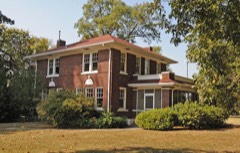 | Campbell House | building | 2006 | 06000841 |
 | First United Methodist Church | building | 1994 | 94000467 |
| Forrest City City Hall | building | 2022 | 100007718 | |
| Forrest City Colored Cemetery | site | 2021 | 100007000 | |
| Forrest City High School | building | 1992 | 92001341 | |
| Forrest City Public Library | building | 2022 | 100007321 | |
| Highway A-1. Forrest City Segment | structure | 2026 | 100012578 | |
| Highway B-1, Little Telico Creek Bridge | structure | 2009 | 09000316 | |
 | Hughes Water Tower | structure | 2006 | 06000905 |
| Mann House | building | 1982 | 82000937 | |
| Smith House | building | 1982 | 82000938 | |
 | St. Francis River Bridge | structure | 1990 | 90000516 |
| William Stone House | building | 1992 | 92001346 | |
| Stuart Springs | site | 1977 | 77001502 |
Every wildfire the federal occurrence database records inside this county: 170 of them, burning about 3,086 acres. 2 started naturally and 60 were recorded as arson. Each settlement page carries the fires within five miles of it.
| Reported cause | Fires |
|---|---|
| Debris and open burning | 67 |
| Arson/incendiarism | 60 |
| Missing data/not specified/undetermined | 21 |
| Equipment and vehicle use | 12 |
| Misuse of fire by a minor | 5 |
| Railroad operations and maintenance | 3 |
| Natural | 2 |
The five largest, by the area the report gives. Three of them were set deliberately.
| Date | Cause | Size | Reported by | Name on the report |
|---|---|---|---|---|
| 8 August 2011 | Equipment and vehicle use | 250 acres | Arkansas Forestry Commission | not named |
| 13 March 2007 | Debris and open burning | 239 acres | Arkansas Forestry Commission | not named |
| 22 March 2007 | Debris and open burning | 149 acres | Arkansas Forestry Commission | not named |
| 1 November 2010 | Debris and open burning | 148 acres | Arkansas Forestry Commission | not named |
| 27 October 2005 | Arson/incendiarism | 135 acres | Arkansas Forestry Commission | not named |
| 30 June 2012 | Debris and open burning | 90 acres | Arkansas Forestry Commission | not named |
| 6 November 2010 | Arson/incendiarism | 80 acres | Arkansas Forestry Commission | not named |
| 4 December 2010 | Arson/incendiarism | 80 acres | Arkansas Forestry Commission | not named |
Every settlement page carries the fires within five miles of it - see the settlement index below.
The NOAA Storm Events Database holds 242 reports for this county, causing 8 deaths, 145 injuries and about $35,867,150 in recorded property damage. Each settlement page carries the reports that name it.
| Kind of event | Reports |
|---|---|
| Thunderstorm Wind | 112 |
| Hail | 81 |
| Tornado | 24 |
| Flash Flood | 19 |
| Flood | 3 |
| Lightning | 2 |
| Heavy Rain | 1 |
The most serious of them, by death, then injury, then recorded damage. The accounts are quoted exactly as the forecast office filed them.
| When | Event | Place named | Harm | What the report says |
|---|---|---|---|---|
| June 1974 | Tornado (F3) | not stated | 4 killed, 112 hurt, $25,000,000 | no account filed |
| April 1982 | Tornado (F2) | not stated | 1 killed, 13 hurt, $250,000 | no account filed |
| December 2013 | Tornado (EF2) | Rawlison | 1 killed, 3 hurt, $500,000 | A tornado touched down six miles west-southwest of Hughes and traveled north-northeast. Three mobile homes were destroyed near Hughes. Roof damage occurred to two homes and a barn was damaged. A number of irrigation pivots were overturned. Near the community of Wildwood a metal shed was destroyed. Power lines were also damaged along the path. The tornado lifted one mile northwest of Tarsus. The peak winds were estimated at 130 mph. |
| April 2011 | Thunderstorm Wind | Hawkins | 1 killed, 1 hurt | A violent thunderstorm with downburst winds estimated at 70 to 80 mph lifted and rolled a double wide home on County Road 267 about 3 miles west of Caldwell. The mobile home traveled 70 feet where it finally landed on its roof. The mobile home was completely destroyed. A couple of vehicles were also heavily damaged. The downburst also removed a large part of the roofing material from the Country Hearth Inn near the interchange of Interstate 40 and Highway 1B in Forrest City. |
| January 2016 | Flood | Newcastle | 1 killed | Heavy rain in late 2015 caused flooding along the St. Francis River through much of January. The St. Francis went above the action stage of 29 feet on the afternoon of January 3, 2016 and then climbed above the flood stage of 32 feet on January 6, 2016. The river remained above flood stage until January 16, 2016. A man was swept away after driving into a flooded road near Newcastle during the late afternoon of January 3, 2016. |
| January 1999 | Tornado (F2) | Wheatley | 9 hurt, $500,000 | The tornado moved into the extreme southwest corner of St. Francis county from Monroe county. It touched down several times and then lifted back into the air. The most severe damage occurred in and near Wheatley. Thirteen homes were completely demolished and six other homes sustained structural damage. Further along its path, the tornado hit a farm about 4.5 miles northeast of Wheatley. The farmhouse lost part of its roof. Two or three machine sheds were demolished, several other outbuildings were damaged, grain storage bins were flatted and blown several hundreds of feet away and irrigation equipment suffered extensive damage. |
| November 2006 | Thunderstorm Wind | Wheatley | 4 hurt, $50,000 | Straight line winds blew seven tractor trailers off of Interstate 40 near Palestine. 4 injuries were reported from crashes. A motel in Wheatley had some roof damage. In addition...a Dollar General store in Forrest City received structural damage from the winds as the store front window was blown in. Several trees and power lines were also knocked down. |
| April 1970 | Tornado (F3) | not stated | 2 hurt, $25,000 | no account filed |
| June 2018 | Thunderstorm Wind | Rosenbaum | 1 hurt, $6,000,000 | Numerous trees down in approximately a two mile swath from near Colt, Arkansas. The hangar at the Delta Regional Airport in Colt was destroyed. In addition, several trees fell on houses along the path and numerous homes had some roof damage. Some power poles were snapped in the damage path. |
| May 2011 | Flood | Newcastle | $752,000 | Heavy rain during late April into early May caused the St. Francis River at Madison and L'Anguille River at Palestine to rise to near record levels. The river remained above flood stage through the end of May. Several homes sustained minor damage from the flooding. Several roads were closed and/or damaged. Several hundred acres of cropland was flooded. |
| June 2014 | Flash Flood | Colt | $500,000 | Very heavy rainfall occurred across much of St. Francis County. Over 7 inches of rain was recorded at Wheatley. Many roads were flooded across the county and homes were evacuated in Madison due to flooding along Crow Creek. Five families were evacuated from homes in the Stonebrook subdicison in Forrest City. |
| July 1992 | Tornado (F1) | not stated | $250,000 | no account filed |
| August 1973 | Tornado (F2) | not stated | $250,000 | no account filed |
| June 2018 | Thunderstorm Wind | Telico | $200,000 | Damage to a Waffle House and two semi-trailers overturned off I-40 and Highway 1 exit. |
| April 2025 | Tornado (EF1) | Shiloh | $125,000 | The tornado started just southwest of Colt, west of SFC 241. Multiple trees were damaged with some minor roof damage to a home along SFC 244. The tornado continued northeast, with a manufactured home destroyed along Highway 306 W and the debris blown away from the structure. Several nearby homes sustained minor roof damage before crossing into Cross County. Peak winds were estimated to be 110 mph. |
| June 2018 | Thunderstorm Wind | Union Hill | $100,000 | Numerous trees and power lines down across town with a widespread power outage. Additional trees down on houses across the city and one trailer north of town. The worst damage stretched along Highway 1. |
| May 2007 | Lightning | Forrest City | $90,000 | Lightning struck a local public housing complex on Rice Street in Forrest City. A fire started and spread to other apartments. No injuries were reported. |
| January 2020 | Thunderstorm Wind | Wheatley | $70,000 | Seven tractor trailers were blown over on Interstate 40 between mile markers 222 and 225 near Wheatley. |
| October 2007 | Thunderstorm Wind | Goodwin | $70,000 | Straight line winds produced damage to a mobile home roof in Goodwin. Two wood frame homes and a metal shop had roof damage. In addition, a grain bin was blown over. 3 miles north of Palestine, several trees were knocked down, blocking County Road 130. Campers and trampolines were tossed about. |
| April 2022 | Lightning | Hughes | $60,000 | Lightning destroyed home in Newcastle community north of Forrest City. The home was a total loss. |
| May 2025 | Thunderstorm Wind | Forrest City Muni Ar | $50,000 | Numerous trees downed on the south side of Forrest City. Several power poles down, a church sustained roof damage, and a metal building sustained significant damage. |
| June 2018 | Thunderstorm Wind | Rosine | $50,000 | House collapsed after roof was torn off. |
| October 2014 | Thunderstorm Wind | Forrest City | $50,000 | Straight line winds blew a roof off a classroom building onto a nearby roof. |
| May 2013 | Tornado (EF1) | Wheatley | $50,000 | A weak tornado crossed from Monroe County into St. Francis County. A few trees and power lines were knocked down. Two tractor trailers were blown off Interstate 40 before the tornado lifted. |
| July 2003 | Thunderstorm Wind | Forrest City | $50,000 | One mobile home was badly damaged. Numerous trees, power poles and power lines were blown down. Nearly 14,000 homes were without power for a couple of days. |
| June 1994 | Thunderstorm Wind | Wheatley | $50,000 | A crop dusting aircraft that was on the ground was damaged. |
| June 1994 | Thunderstorm Wind | Forrest City | $50,000 | Some roofs were damaged. |
| June 1994 | Thunderstorm Wind | Palestine | $50,000 | Thunderstorm winds damaged a church. |
| January 1996 | Tornado (F1) | Hughes | $50,000 | no account filed |
| June 2009 | Thunderstorm Wind | Rosine | $45,000 | Straight line winds produced major damage to a mobile home near Forrest City. In addition, several outbuildings received minor damage as well as a church. |
| February 2008 | Thunderstorm Wind | Horton | $35,000 | Straight line winds blew trees down on three vehicles at a home off of County Road 224, outside of Forrest City. |
| June 2019 | Thunderstorm Wind | Rosenbaum | $30,000 | Large tree down across Highway 306 west and another tree on a house close to Colt. |
| May 2021 | Tornado (EF0) | Wood Spur | $25,000 | A brief tornado damaged a barn and storage building. It removed metal roof panels from a house and uprooted several trees. Peak winds were estimated at 85 mph. |
| May 2009 | Flash Flood | Pinetree | $25,000 | Heavy rain produced flash flooding around St. Francis County. Numerous roads were flooded and closed. County roads 815 and 808 sustained the worst damage. Highway 1 South between Forrest City and Haynes was closed for 2 hours with water up to 5 feet deep. A woman was rescued from her car on Highway 1 South about 2 miles north of Haynes after she drove into a flooded area and the vehicle was pushed off the road and into a ditch. No homes or businesses were damaged. |
| October 2009 | Flash Flood | Forrest City | $25,000 | Parts of State Highway 1 between Forrest City and Wynne were flooded. Six homes and one car dealership were flooded in that area. Several other homes west of Forrest City near County Road 226 had water approaching them. At least two people were evacuated from this area. |
| July 2008 | Thunderstorm Wind | Rawlison | $25,000 | Straight line winds damaged two mobile homes and overturned another near the intersection of Highway 38 East and County Road 753. Trees and power lines were also knocked down in the area. |
| March 2008 | Thunderstorm Wind | Forrest City | $25,000 | The roof and carport of a house located on Red Haven Drive in Forrest City were damaged by straight line winds. Numerous power lines were knocked down across the city as well. |
| February 2000 | Tornado (F0) | Hughes | $25,000 | A mobile home was overturned. Several homes were damaged. |
| February 1971 | Tornado (F2) | not stated | $25,000 | no account filed |
| April 2017 | Thunderstorm Wind | Wheatley | $20,000 | Power lines down. |
| May 2003 | Thunderstorm Wind | Forrest City | $20,000 | The Hughes High School gymnasium had most of its roof blown off. The locker rooms near the football field were also damaged. Several trees and power lines were knocked down. |
| April 2025 | Tornado (EF0) | Walkers Store | $15,000 | A brief tornado formed just north of Interstate 40 near SFC 513, overturning a center irrigation pivot before crossing into Crittenden County. |
| July 2005 | Thunderstorm Wind | Forrest City | $15,000 | A couple of trees and power poles were blown down. |
| July 2002 | Thunderstorm Wind | Forrest City | $15,000 | A fence was damaged. Several trees and power poles were knocked down. One tree fell on a shed. |
| April 1999 | Thunderstorm Wind | Forrest City | $15,000 | A roof was blown off of a house trailer. Several trees were knocked down. |
| April 1997 | Thunderstorm Wind | Forrest City | $11,000 | A car wash and a liquor store suffered roof damage. Several trees and power lines were also knocked down. |
| April 2025 | Hail | Forrest City | $10,000 | Several car windows broken from large hail. |
| August 2020 | Thunderstorm Wind | Pinetree | $10,000 | Downed trees and power lines were reported on Route 306 west of Colt. A tree fell on Pine Tree Baptist Church. |
| June 2017 | Thunderstorm Wind | Shannondale | $10,000 | Trees blown down on Highway 38 in Hughes resulting in power lines landing on a car. |
| July 2008 | Thunderstorm Wind | Forrest City | $10,000 | Straight line winds knocked down trees and power lines across St. Francis County. |
| July 2005 | Thunderstorm Wind | Caldwell | $10,000 | A large tree limb blew through a mobile home. |
| April 2001 | Hail | Colt | $10,000 | Thirty-three cars on a used car lot in Colt were damaged by the hail. |
| May 2001 | Thunderstorm Wind | Forrest City | $10,000 | A roof collapsed on a building at a country club. A few trees were blown down. |
| April 2000 | Thunderstorm Wind | Forrest City | $10,000 | Several trees and power lines were blown down. |
| June 1997 | Thunderstorm Wind | Forrest City | $10,000 | Several buildings suffered damage to their roofs and awnings. Numerous trees and power lines were blown down. |
| June 2011 | Thunderstorm Wind | Wheatley | $5,000 | Straight line winds produced roof damage to a restaurant in Wheatley. |
| February 2008 | Thunderstorm Wind | Palestine | $5,000 | Straight line winds blew a car off a road, roughly 8 miles northwest of Palestine. |
| May 2008 | Hail | Wheatley | $5,000 | Golf ball size hail fell on Interstate 40 near Wheatley. |
| July 2005 | Thunderstorm Wind | Madison | $5,000 | Around 10 trees were blown down. |
| August 2003 | Thunderstorm Wind | Forrest City | $5,000 | Some tree limbs and power lines were knocked down. |
The Survey's mineral resources record lists 12 workings inside this county. 3 still produce and 9 are closed or unrecorded. Each settlement page carries the workings within five miles of it.
| Commodity | Workings |
|---|---|
| Sand and Gravel, Construction | 12 |
The least common of them first, because a county's hundredth gravel pit says nothing its first ten did not.
| Where | Site | Commodity | Status | Recorded |
|---|---|---|---|---|
| Colvins Pit | Sand and Gravel, Construction | Past Producer | ||
| Crisp Pit | Sand and Gravel, Construction | Producer | ||
| Forrest City Pit | Sand and Gravel, Construction | Producer | ||
| Forrest City Pit & Plant | Sand and Gravel, Construction | Producer | ||
| St.Francis Materials Co | Sand and Gravel, Construction | Past Producer | ||
| Unk | Sand and Gravel, Construction | Past Producer | ||
| Unk | Sand and Gravel, Construction | Past Producer | ||
| Unk | Sand and Gravel, Construction | Past Producer | ||
| Unk | Sand and Gravel, Construction | Past Producer | ||
| Unk | Sand and Gravel, Construction | Past Producer | ||
| Unk | Sand and Gravel, Construction | Past Producer | ||
| Woods Gravel Pit | Sand and Gravel, Construction | Past Producer |
Named settlements recorded in the Geographic Names Information System, each with the topographic sheets covering it. Villages, hamlets and abandoned places alike. Each is shown with the nearest named watercourse or landform and the survey quadrangle it falls on.
Griggs township · 72394 · On Tenmile Bayou · Round Pond quadrangle
13 sheets, 1940 to 1986
Telico township · 72326 · On Little Telico Creek · Forrest City quadrangle
12 sheets, 1939 to 1986
Madison township · 72335 · On Little Crow Creek · Madison quadrangle
14 sheets, 1940 to 1986
Griggs township · 72394 · On Allen Bayou · Round Pond quadrangle
13 sheets, 1940 to 1986
Griggs township · 72394 · Mud Lake quadrangle
18 sheets, 1939 to 1990
No longer a settlement
Johnson township · 72335 · On Griggs Creek · Forrest City quadrangle
12 sheets, 1939 to 1986
Griggs township · 72394 · On Little Bivens Bayou · Gieseck quadrangle
13 sheets, 1940 to 1986
Madison township · 72335 · Forrest City quadrangle
12 sheets, 1939 to 1986
No longer a settlement
Johnson township · 72335 · By Burnt Mill Bluff · Madison quadrangle
14 sheets, 1940 to 1986
Griggs township · 72346 · Gieseck quadrangle
13 sheets, 1940 to 1986
No longer a settlement
Franks township · 72335 · On Blackfish Bayou · Dansby quadrangle
20 sheets, 1939 to 1990
No longer a settlement
Griggs township · 72394 · On Tenmile Bayou · Round Pond quadrangle
13 sheets, 1940 to 1986
Prairie township · 72372 · On Cypress Creek · Hawkins quadrangle
12 sheets, 1939 to 1992
Telico township · 72335 · On Little Telico Creek · Forrest City quadrangle
12 sheets, 1939 to 1986
No longer a settlement
Telico township · 72326 · On Little Telico Creek · Forrest City quadrangle
12 sheets, 1939 to 1986
L'Anguille township · 72372 · Hawkins quadrangle
12 sheets, 1939 to 1992
No longer a settlement
Franks township · 72335 · On Wyles Pond Slough · Dansby quadrangle
20 sheets, 1939 to 1990
No longer a settlement
The vanished settlements of St. Francis County: the places named above that are no longer on the map.