 Block
From the record
One of 16 National Register listings published here for St. Francis County · listed in 1977 · category: Site.
Sources: the National Register database, National Park Service
Listed on the National Register of Historic Places in 1977.
One of 16 National Register listings published here for St. Francis County · listed in 1977 · category: Site.
Sources: the National Register database, National Park Service
Regional context, not property-specific evidence. The federal wildfire occurrence database lists 53 fires within 5 miles of Stuart Springs between 1997 and 2020, burning about 474 acres in total. None started naturally. 17 were recorded as arson. Distance is straight-line from the map coordinates, so a fire counted here may appear on a neighbouring settlement's page as well.
| Reported cause | Fires |
|---|---|
| Debris and open burning | 22 |
| Arson/incendiarism | 17 |
| Missing data/not specified/undetermined | 6 |
| Equipment and vehicle use | 5 |
| Misuse of fire by a minor | 3 |
The most recent of them, most recent first, with the day each was reported and the service that recorded it.
| Date | Cause | Size | Reported by | Name on the report |
|---|---|---|---|---|
| 3 September 2000 | Equipment and vehicle use | 1.0 acres | Arkansas Forestry Commission | not named |
| 27 September 1999 | Debris and open burning | 3.0 acres | Arkansas Forestry Commission | not named |
| 13 September 2002 | Missing data/not specified/undetermined | 1.0 acres | Arkansas Forestry Commission | not named |
| 18 August 1999 | Equipment and vehicle use | 2.0 acres | Arkansas Forestry Commission | not named |
| 11 August 2000 | Debris and open burning | 2.0 acres | Arkansas Forestry Commission | not named |
| 7 July 1998 | Arson/incendiarism | 29 acres | Arkansas Forestry Commission | not named |
| 17 May 2001 | Debris and open burning | 1.0 acres | Arkansas Forestry Commission | not named |
| 5 April 2005 | Debris and open burning | 2.0 acres | Arkansas Forestry Commission | not named |
Regional context, not property-specific evidence. The federal mineral resources record lists 11 workings within 5 miles of Stuart Springs: 8 past producers, 3 producers. 3 still produce. What was taken out: Sand and Gravel, Construction. Distance is straight-line from the map coordinates, so a quarry counted here may appear on a neighbouring settlement's page as well.
| Where | Site | Commodity | Status | Recorded |
|---|---|---|---|---|
| Colvins Pit | Sand and Gravel, Construction | Past Producer | ||
| Crisp Pit | Sand and Gravel, Construction | Producer | ||
| Forrest City Pit | Sand and Gravel, Construction | Producer | ||
| Forrest City Pit & Plant | Sand and Gravel, Construction | Producer | ||
| St.Francis Materials Co | Sand and Gravel, Construction | Past Producer | ||
| Unk | Sand and Gravel, Construction | Past Producer | ||
| Unk | Sand and Gravel, Construction | Past Producer | ||
| Unk | Sand and Gravel, Construction | Past Producer | ||
| Unk | Sand and Gravel, Construction | Past Producer | ||
| Unk | Sand and Gravel, Construction | Past Producer |
Regional context, not property-specific evidence. The National Weather Service names Forrest City, the town this property stands in, in 52 storm reports between 1994 and 2025: 25 thunderstorm wind, 19 hail, 6 flash flood, 1 flood. No death or injury is recorded in these reports. Each account below is quoted exactly as the forecast office filed it, from the NOAA Storm Events Database, and each date opens the federal record of that event.
| When | Event | Place named | Harm | What the report says |
|---|---|---|---|---|
| May 2007 | Lightning | Forrest City | $90,000 | Lightning struck a local public housing complex on Rice Street in Forrest City. A fire started and spread to other apartments. No injuries were reported. |
| October 2014 | Thunderstorm Wind | Forrest City | $50,000 | Straight line winds blew a roof off a classroom building onto a nearby roof. |
| July 2003 | Thunderstorm Wind | Forrest City | $50,000 | One mobile home was badly damaged. Numerous trees, power poles and power lines were blown down. Nearly 14,000 homes were without power for a couple of days. |
| June 1994 | Thunderstorm Wind | Forrest City | $50,000 | Some roofs were damaged. |
| October 2009 | Flash Flood | Forrest City | $25,000 | Parts of State Highway 1 between Forrest City and Wynne were flooded. Six homes and one car dealership were flooded in that area. Several other homes west of Forrest City near County Road 226 had water approaching them. At least two people were evacuated from this area. |
| March 2008 | Thunderstorm Wind | Forrest City | $25,000 | The roof and carport of a house located on Red Haven Drive in Forrest City were damaged by straight line winds. Numerous power lines were knocked down across the city as well. |
| May 2003 | Thunderstorm Wind | Forrest City | $20,000 | The Hughes High School gymnasium had most of its roof blown off. The locker rooms near the football field were also damaged. Several trees and power lines were knocked down. |
| July 2005 | Thunderstorm Wind | Forrest City | $15,000 | A couple of trees and power poles were blown down. |
| July 2002 | Thunderstorm Wind | Forrest City | $15,000 | A fence was damaged. Several trees and power poles were knocked down. One tree fell on a shed. |
| April 1999 | Thunderstorm Wind | Forrest City | $15,000 | A roof was blown off of a house trailer. Several trees were knocked down. |
| April 1997 | Thunderstorm Wind | Forrest City | $11,000 | A car wash and a liquor store suffered roof damage. Several trees and power lines were also knocked down. |
| April 2025 | Hail | Forrest City | $10,000 | Several car windows broken from large hail. |
| July 2008 | Thunderstorm Wind | Forrest City | $10,000 | Straight line winds knocked down trees and power lines across St. Francis County. |
| May 2001 | Thunderstorm Wind | Forrest City | $10,000 | A roof collapsed on a building at a country club. A few trees were blown down. |
| April 2000 | Thunderstorm Wind | Forrest City | $10,000 | Several trees and power lines were blown down. |
| June 1997 | Thunderstorm Wind | Forrest City | $10,000 | Several buildings suffered damage to their roofs and awnings. Numerous trees and power lines were blown down. |
| August 2003 | Thunderstorm Wind | Forrest City | $5,000 | Some tree limbs and power lines were knocked down. |
| April 2001 | Thunderstorm Wind | Forrest City | $5,000 | One building was damaged. Some trees were blown down. |
| January 1999 | Thunderstorm Wind | Forrest City | $5,000 | A few large trees were knocked down. |
| June 1998 | Thunderstorm Wind | Forrest City | $5,000 | Some trees were blown down just east of Forrest City. |
| July 1995 | Thunderstorm Wind | Forrest City | $5,000 | Some power lines were blown down. |
| November 1995 | Thunderstorm Wind | Forrest City | $5,000 | Several trees were knocked down. One tree fell onto a house. |
| June 1994 | Thunderstorm Wind | Forrest City | $5,000 | Thunderstorm winds downed some telephone lines. |
| June 1994 | Thunderstorm Wind | Forrest City | $5,000 | Thunderstorm winds blew down a few trees, one of which fell on top of a house. |
| April 2022 | Thunderstorm Wind | Forrest City | $2,000 | Utility pole knocked down along Highway 1 south of Forrest City. |
| November 1996 | Thunderstorm Wind | Forrest City | $2,000 | no account filed |
| November 1996 | Thunderstorm Wind | Forrest City | $2,000 | no account filed |
| March 2004 | Flash Flood | Forrest City | $1,000 | Several roads were flooded. |
| April 2004 | Flash Flood | Forrest City | $1,000 | Several streets were flooded. |
| April 1999 | Flood | Forrest City | $1,000 | Highway 70 near Forrest City was flooded with 4 to 5 inches of water on the road. |
| June 2001 | Hail | Forrest City | $250 | no account filed |
| May 2001 | Hail | Forrest City | $100 | no account filed |
| January 1999 | Hail | Forrest City | $100 | no account filed |
| May 2002 | Hail | Forrest City | $50 | no account filed |
| June 2001 | Hail | Forrest City | $50 | no account filed |
| March 1996 | Hail | Forrest City | $20 | no account filed |
| May 2003 | Hail | Forrest City | $10 | no account filed |
| May 2003 | Hail | Forrest City | $10 | no account filed |
| April 2025 | Hail | Forrest City | - | Baseball sized hail fell in the 100 block of Washington St. |
| March 2016 | Flash Flood | Forrest City | - | Highway 1 was closed due to flash flooding. |
| December 2013 | Flash Flood | Forrest City | - | Heavy rain produced flash flooding in St. Francis County. Highway 261 near Palestine was flooded. Dawson and Washington Roads were flooded in Forrest City. |
| February 2011 | Thunderstorm Wind | Forrest City | - | Straight line winds propelled tree branches through the roof of a home in Forrest City and another home in Madison. Power poles were knocked down in Forrest City as well. |
| May 2008 | Flash Flood | Forrest City | - | Heavy rain produced street flooding along Highway 1, south of Forrest City. |
| June 1994 | Hail | Forrest City | - | Thunderstorm winds blew down a few trees, one of which fell on top of a house. |
| April 2025 | Hail | Forrest City | - | no account filed |
| April 2025 | Hail | Forrest City | - | no account filed |
| May 2011 | Hail | Forrest City | - | no account filed |
| April 2011 | Hail | Forrest City | - | no account filed |
| May 2010 | Hail | Forrest City | - | no account filed |
| May 2010 | Hail | Forrest City | - | no account filed |
| May 2010 | Hail | Forrest City | - | no account filed |
| January 1995 | Hail | Forrest City | - | no account filed |
No historic map-sheet match is published for this property yet. That does not mean no map exists. This record needs a coordinate-quality review before it can be joined to a sheet boundary. Browse the county's mapped places while that work is pending.
Other National Register properties close enough to walk or drive between, ordered by distance from this one. Both positions come from the same geocoding pass that matched these properties to their map sheets.
| Photograph | Property | Distance | Listed |
|---|---|---|---|
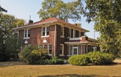 | Campbell House | 0.5 miles | 2006 |
| Forrest City High School | 0.6 miles | 1992 | |
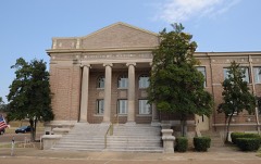 | First United Methodist Church | 0.7 miles | 1994 |
| Forrest City City Hall | 0.7 miles | 2022 | |
| Forrest City Colored Cemetery | 0.8 miles | 2021 | |
| Forrest City Public Library | 0.9 miles | 2022 |
| National Archives record | The nomination case file for reference 77001502 in Record Group 79. |
| St. Francis County | All 16 listed properties in this county. |