
BlockBefore
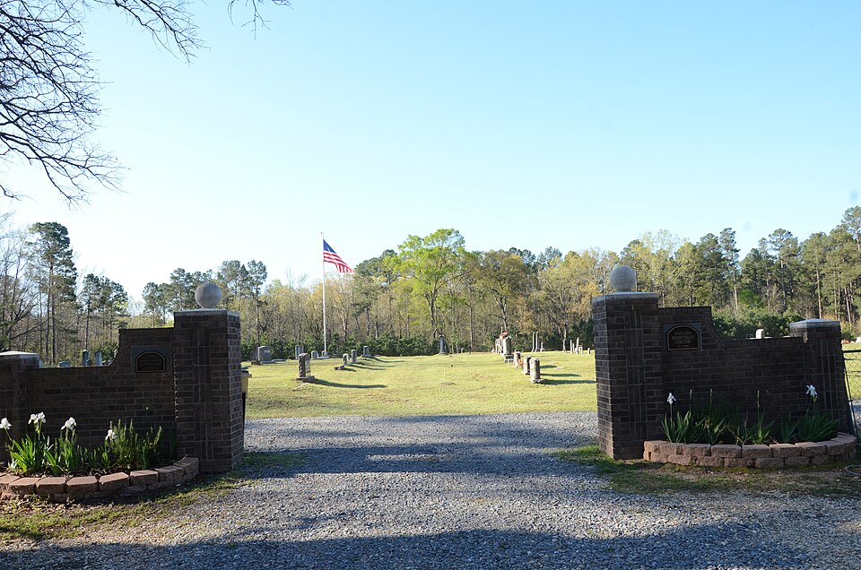
Photograph of Scotland Cemetery
Photograph by Valis55, CC BY-SA 3.0. Via Wikimedia Commons.

Scotland Cemetery

Listed on the National Register of Historic Places in 2005.

From the record

“The Scotland Cemetery is a historic cemetery in Scotland, an unincorporated community in rural Union County, Arkansas. It is located about 3 miles (4.8 km) west of Junction City, off US Route 167 south of the Scotland Presbyterian Church.”

Wikipedia article Scotland Cemetery, CC BY-SA 4.0.

One of 40 National Register listings published here for Union County · listed in 2005 · category: Site.

Sources: the Wikipedia article · the National Register database, National Park Service

The listing

  • What is counted as historic. The nomination lists 1 site as contributing to the listing.
  • Address. US 167, 3 mi. W of Junction City, Junction City, 71749
  • When was it listed? September 2005
  • Category. site
  • Township. Henderson township
  • National Register reference number. 05001081 - assigned by the National Park Service when the property was listed.

Fires near this property

51 since 1999

Regional context, not property-specific evidence. The federal wildfire occurrence database lists 51 fires within 5 miles of Scotland Cemetery between 1999 and 2018, burning about 356 acres in total. 2 started naturally. 7 were recorded as arson. Distance is straight-line from the map coordinates, so a fire counted here may appear on a neighbouring settlement's page as well.

Reported cause Fires
Missing data/not specified/undetermined21
Debris and open burning15
Arson/incendiarism7
Equipment and vehicle use4
Natural2
Power generation/transmission/distribution1
Recreation and ceremony1

The most recent of them, most recent first, with the day each was reported and the service that recorded it.

DateCause SizeReported by Name on the report
26 September 2011Arson/incendiarism1.0 acresArkansas Forestry Commissionnot named
26 September 2011Arson/incendiarism2.0 acresArkansas Forestry Commissionnot named
24 September 1999Missing data/not specified/undetermined2.0 acresArkansas Forestry Commissionnot named
27 August 2007Missing data/not specified/undetermined2.0 acresArkansas Forestry Commissionnot named
25 August 1999Natural1.0 acresArkansas Forestry Commissionnot named
22 August 2012Missing data/not specified/undetermined4.0 acresArkansas Forestry Commissionnot named
2 August 2015Debris and open burning3.0 acresArkansas Forestry Commissionnot named
13 August 2005Debris and open burning1.0 acresArkansas Forestry Commissionnot named

Every fire recorded in Union County

Storms near this property

20 since 1993

Regional context, not property-specific evidence. The National Weather Service names Junction City, the town this property stands in, in 20 storm reports between 1993 and 2019: 12 thunderstorm wind, 4 hail, 4 tornado. The reports record 2 deaths and 18 injuries. Each account below is quoted exactly as the forecast office filed it, from the NOAA Storm Events Database, and each date opens the federal record of that event.

WhenEvent Place namedHarm What the report says
January 2005Tornado (F3)Junction City2 killed, 13 hurt, $3,000,000The tornado that moved through Claiborne Parish Louisiana moved northeast into Union County Arkansas. The tornado first struck the community of Junction City, Arkansas just north of the Arkansas, Louisiana state line. From the area surveyed, the tornado was on the ground continuously from touchdown to end. For the early part of the track, the damage was confined to minor damage to homes with numerous trees downed from Junction City to near Tatum Rd approximately 8 miles south of El Dorado. In Junction City, two people were injured when a tree fell on their home as they were in bed. As the tornado approached Tatum Rd, it appears to have intensified significantly while growing wider in its destruction. It was through the area from Tatum Rd, across Hwy 7 and into the vicinity of Rushwood Rd that the storm did its greatest damage. Numerous homes, both mobile and well constructed frame homes were either destroyed or heavily damaged. A number of vehicles were rolled and tossed through the air, landing several yards from their initial location. It was in the area of Tatum Rd through Rushwood Rd that two fatalities occurred, both of them elderly residents. The majority of the injuries also occurred in this area. After leaving the Rushwood Rd area, the storm began to weaken and decreasing in path width. Except for minor structural damage to buildings in Lawson, trees downed or broken was the main damage for the latter part of the track.
February 2007Tornado (EF3)Junction City5 hurtA strong tornado developed under a supercell thunderstorm which moved northeast across the county. Damage was largely confined to heavily wooded areas with less than 20 structures sustaining damage. Six of these structures received heavy damage near the community of Strong, Arkansas. Numerous snapped and fallen large trees were also observed.|The extent of the damage ranged from shingles off some homes to others completely demolished. Of the 6 homes that were severly damaged...two were mobile homes. The tornado began in extreme southwest Union County near Junction City where a metal roof was blown off a pharmacy on Route 167. The tornado produced sporadic tree damage along Welloo and Welch roads. Moving northeast...the tornado downed additional trees across Caledonia and Iron Mountain roads. The tornado continued in a northeast direction...crossing Hwy 82 and intensified as it crossed Old Strong highway. Here a well build brick home was mostly demolished. The tornado traveled a half mile east and demolished a double wide trailer blowing the debris 150 to 200 yards downstream. Several other homes were affected from this storm before the storm lifted near the community of New London. Five injuries were reported from this tornado with no fatalities. At the most damaging point of the storm after it crossed Hwy 82...the storm was rated an EF3 on the new enhanced Fujita scale. A monetary damage amount was not available for this publication. |The Damage Indicator for the event was (DI): FR 12 while the Degree of Damage for the event was (DOD): 8.
October 2009Thunderstorm WindJunction City$250,000Trees were downed in the community of Junction City, Arkansas blocking four city streets. Damage was also reported in town where trees were downed at the intersection of North Newton and Oakhurst Boulevard. Nearly 20 trees were downed within a quarter mile stretch at Ebenezer Road were several structures also received damage. Two mobile homes were destroyed. Also, a home was damaged on Smith Street in El Dorado, Arkansas. Trees also fell on two vehicles across the county and a canopy was damaged at the Yocum Elementary School.
February 2008Tornado (EF0)Junction City$200,000The tornado snapped off many trees along a seven mile path starting 2 miles west of Junction City, Arkansas to 5 miles north northeast of Junction City, Arkansas. Several porches and awnings were destroyed in the town and there was roof damage throughout the north side of the city. Severe roof damage was reported to the Juncition City First United Methodist Church.
April 1993Thunderstorm WindJunction City$5,000Thunderstorm winds, estimated up to 40 mph, knocked down a large pine tree and tore an aluminum awning off of a shed.
April 2019Thunderstorm WindJunction City-Trees were blown down across the southern sections of Union County.
April 2018Thunderstorm WindJunction City-Several hardwood trees were uprooted in Junction City.
April 2015Thunderstorm WindJunction City-Powerlines were downed north of Junction City, Arkansas.
May 2013HailJunction City-Hail covered the ground in Junction City, Arkansas.
August 2011Thunderstorm WindJunction City-Trees were downed near Junction City.
July 2011Thunderstorm WindJunction City-Trees were downed along Hwy. 167 south of El Dorado.
July 2007Thunderstorm WindJunction City-Trees and power lines downed on Welch Road and State Line Road.
April 2003Tornado (F2)Junction City-A strong tornado developed under a supercell which moved east across the southern portion of the county. Damage was largely confined to heavily wooded areas with only a few structures suffering light to moderate damage. Numerous snapped and fallen large trees were observed.
July 2003Thunderstorm WindJunction City-Numerous large trees down.
July 2002Thunderstorm WindJunction City-Several large trees down in town.
November 1995Thunderstorm WindJunction City-Power lines were reported blown down.
May 2013HailJunction City-no account filed
May 2003HailJunction City-no account filed
February 1997Thunderstorm WindJunction City-no account filed
January 1994HailJunction City-no account filed

Every storm recorded in Union County

Map coverage status

No historic map-sheet match is published for this property yet. That does not mean no map exists. This record needs a coordinate-quality review before it can be joined to a sheet boundary. Browse the county's mapped places while that work is pending.

Sources for this property

National Archives recordThe nomination case file for reference 05001081 in Record Group 79.
Wikipedia articleCommunity-written account of this property, licensed CC BY-SA.
Union CountyAll 40 listed properties in this county.

Provenance

  • Listing record. National Park Service National Register of Historic Places, listed-properties dataset, current to 2026-05-22.
  • Map join. Address geocoded through the United States Census geocoder, then tested against the published boundary of every sheet in the USGS Historical Topographic Map Collection.
  • How this page is made. Listing fields come from federal records; map-sheet coverage is a labelled coordinate-to-boundary calculation, not a source-field claim.
  • Wildfire. Short, Karen C. 2022. Spatial wildfire occurrence data for the United States, 1992-2020 [FPA_FOD_20221014]. 6th Edition. Fort Collins, CO: Forest Service Research Data Archive. https://doi.org/10.2737/RDS-2013-0009.6 Collected with United States Government funding and usable without additional permissions or fees.
  • Storms. NOAA National Centers for Environmental Information, Storm Events Database https://www.ncei.noaa.gov/stormevents/ A work of the United States government, no copyright under 17 U.S.C. 105. Narratives are quoted verbatim from the National Weather Service report and are not edited or summarised.