
BlockBefore
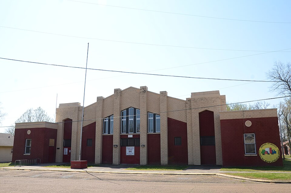
Photograph of Helena National Guard Armory
Photograph by Valis55, CC BY-SA 3.0. Via Wikimedia Commons.

Helena National Guard Armory

Listed on the National Register of Historic Places in 2007.

From the record

“The Helena National Guard Armory is a historic armory building at 511 Miller Street in Helena, Arkansas. It is a single-story brick-and-masonry structure, built in 1936-37 using Works Progress Administration funds to house the Battery G of the 206th Coastal Artillery.”

Wikipedia article Helena National Guard Armory, CC BY-SA 4.0.

One of 60 National Register listings published here for Phillips County · listed in 2007 · category: Building.

Sources: the Wikipedia article · the National Register database, National Park Service

The listing

  • What is counted as historic. The nomination lists 1 building as contributing to the listing.
  • Address. 511 Miller St., Helena--West Helena, 71923
  • When was it listed? January 2007
  • Category. building
  • Also known as. New Deal Recovery Efforts in Arkansas MPS
  • National Register reference number. 06001266 - assigned by the National Park Service when the property was listed.

Storms near this property

18 since 2008

Regional context, not property-specific evidence. The National Weather Service names Helena--West Helena, the town this property stands in, in 18 storm reports between 2008 and 2025: 12 thunderstorm wind, 4 flash flood, 2 hail. No death or injury is recorded in these reports. Each account below is quoted exactly as the forecast office filed it, from the NOAA Storm Events Database, and each date opens the federal record of that event.

WhenEvent Place namedHarm What the report says
May 2009Flash FloodHelena - West Helena$500,000Heavy rain produced flash flooding across portions of Phillips County including Helena-West Helena, Elaine, Marvell, Barton and Lake View. Numerous roads were closed and several homes were inundated with water. The police department in Marvell had three to four feet of water inside.
January 2012Thunderstorm WindHelena - West Helena$100,000Several mobile homes were destroyed on the west side of West Helena. One mobile home was flipped on the southwest side of a neighborhood on the outskirts of town. The bottom frame of the home struck a tree behind the home 15 feet in the air. The mobile home landed on its roof and was completely destroyed. Cars were damaged by flying debris and trees were also blown down. Another neighborhood southwest of town was damaged as well. In this neighborhood, two mobile homes were flipped. One was blown into another mobile home and a wood house. Power lines and irrigation systems were blown down in the fields between the two neighborhoods. In West Helena, only minor damage was noted to the Junior High School roof and the roof and siding of a few motels. A few storage sheds were blown over but had not been secured to the ground.
June 2020Flash FloodHelena - West Helena$50,000Vehicles were stranded in floodwaters. Water rescues were necessary.
March 2022Thunderstorm WindHelena - West Helena$25,000Powerlines and trees down on Waverly Wood Drive, Springdale Road, and Oakland Avenue, along with other various locations in Helena-West Helena. Storage buildings also suffered damage on Highway 49 near Helena Regional Hospital.
June 2025Thunderstorm WindHelena - West Helena$10,000Trees were knocked down, and a tree landed on a home at the 300 block of Waverly Road in Helena, AR.
March 2019Thunderstorm WindHelena - West Helena$10,000Large tree down on building, snapped at the base of the tree.
April 2025Thunderstorm WindHelena - West Helena$5,000Downed trees and powerlines in between Highland St and Arkansas St in Helena-West Helena.
May 2025Thunderstorm WindHelena - West Helena$4,000Trees downed in Helena-West Helena.
June 2008Thunderstorm WindHelena - West Helena$4,000Straight line winds blew several trees and power lines down near Helena-West Helena.
August 2008Thunderstorm WindHelena - West Helena$4,000Straight line winds knocked several trees and large limbs down in Helena-West Helena.
May 2022Thunderstorm WindHelena - West Helena$3,000Trees down blocking Phillips Street in Helena-West Helena.
January 2010Thunderstorm WindHelena - West Helena$250Straight line winds knocked a large billboard for a high school down in Helena-West Helena. Debris was also strewn across the city.
June 2023HailHelena - West Helena-Quarter size hail fell in Helena - West Helena.
June 2020Thunderstorm WindHelena - West Helena-Trees and powerlines were knocked down on Springdale Road.
June 2011Thunderstorm WindHelena - West Helena-Straight line winds knocked a tree down on Military Road in Helena-West Helena. In addition, several trees were knocked down across eastern sections of Helena-West Helena.
April 2011Flash FloodHelena - West Helena-Heavy rain caused flash flooding in Helena-West Helena. A block and a half of Highway 49 was flooded.
April 2011HailHelena - West Helena-Golf ball size hail fell at the Helena Bridge.
July 2010Flash FloodHelena - West Helena-Heavy rain produced flash flooding near Helena-West Helena. As a result, ditches overflowed flooding many streets.

Every storm recorded in Phillips County

Map coverage status

No historic map-sheet match is published for this property yet. That does not mean no map exists. This record needs a coordinate-quality review before it can be joined to a sheet boundary. Browse the county's mapped places while that work is pending.

Sources for this property

National Archives recordThe nomination case file for reference 06001266 in Record Group 79.
Wikipedia articleCommunity-written account of this property, licensed CC BY-SA.
Phillips CountyAll 60 listed properties in this county.

Provenance

  • Listing record. National Park Service National Register of Historic Places, listed-properties dataset, current to 2026-05-22.
  • Map join. Address geocoded through the United States Census geocoder, then tested against the published boundary of every sheet in the USGS Historical Topographic Map Collection.
  • How this page is made. Listing fields come from federal records; map-sheet coverage is a labelled coordinate-to-boundary calculation, not a source-field claim.
  • Storms. NOAA National Centers for Environmental Information, Storm Events Database https://www.ncei.noaa.gov/stormevents/ A work of the United States government, no copyright under 17 U.S.C. 105. Narratives are quoted verbatim from the National Weather Service report and are not edited or summarised.