BlockBefore
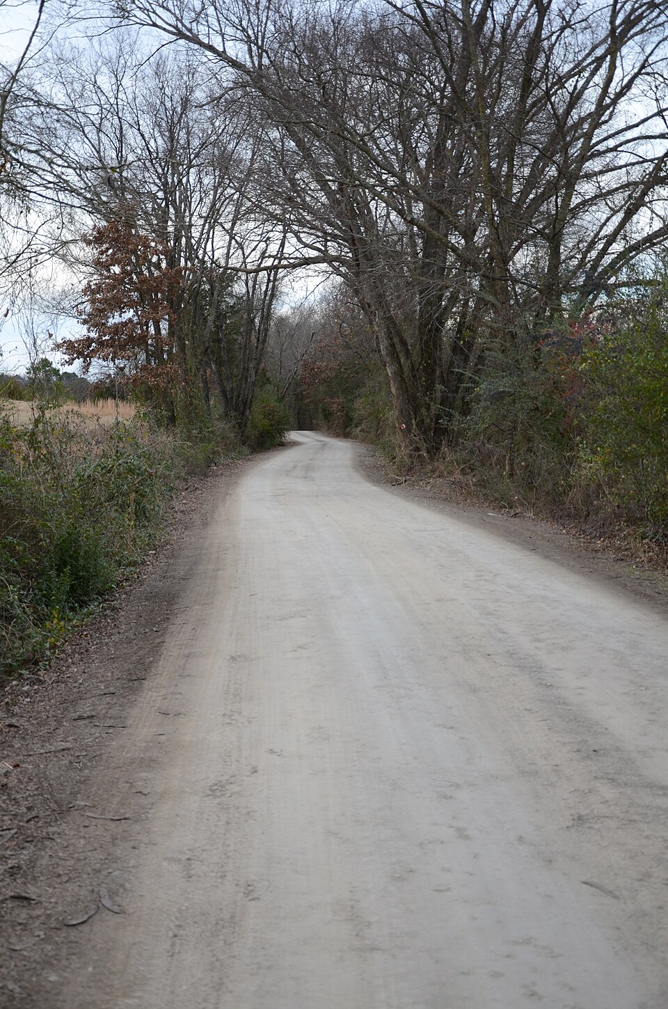
Photograph of Little Rock to Cantonment Gibson Road-Short Mountain Segment
Photograph by Valis55, CC BY-SA 3.0. Via Wikimedia Commons.

Little Rock to Cantonment Gibson Road-Short Mountain Segment

Listed on the National Register of Historic Places in 2008.

From the record

“The Little Rock to Cantonment Gibson Road-Short Mountain Segment is a historic 19th-century road section in Logan County, Arkansas. It is located northwest of Paris, consisting of 3.7 miles (6.0 km) of Short Mountain Road, extending westward from its crossing with Short Mountain Creek.”

Wikipedia article Little Rock to Cantonment Gibson Road-Short Mountain Segment, CC BY-SA 4.0.

One of 44 National Register listings published here for Logan County · listed in 2008 · category: Structure.

Sources: the Wikipedia article · the National Register database, National Park Service

The listing

  • What is counted as historic. The nomination lists 1 structure as contributing to the listing.
  • Listed as. Little Rock to Cantonment Gibson Road--Short Mountain Segment - the National Register files a house under its owner's surname.
  • Address. Short Mt. Rd. between Horseshoe Mt. and Short Mt. Cr., Paris, 72855
  • When was it listed? January 2008
  • Category. structure
  • Township. Short Mountain township
  • National Register reference number. 07001429 - assigned by the National Park Service when the property was listed.

Fires near this property

77 since 1997

Regional context, not property-specific evidence. The federal wildfire occurrence database lists 77 fires within 5 miles of Little Rock to Cantonment Gibson Road-Short Mountain Segment between 1997 and 2020, burning about 575 acres in total. 2 started naturally. 8 were recorded as arson. Distance is straight-line from the map coordinates, so a fire counted here may appear on a neighbouring settlement's page as well.

Reported cause Fires
Debris and open burning39
Missing data/not specified/undetermined19
Arson/incendiarism8
Equipment and vehicle use7
Natural2
Misuse of fire by a minor1
Smoking1

The most recent of them, most recent first, with the day each was reported and the service that recorded it.

DateCause SizeReported by Name on the report
8 September 2005Missing data/not specified/undetermined1.0 acresArkansas Forestry Commissionnot named
6 September 2005Debris and open burning2.0 acresArkansas Forestry Commissionnot named
20 September 2010Debris and open burning2.0 acresArkansas Forestry Commissionnot named
18 September 2000Debris and open burning1.0 acresArkansas Forestry Commissionnot named
11 September 1998Arson/incendiarism70 acresArkansas Forestry Commissionnot named
10 September 2004Arson/incendiarism2.0 acresArkansas Forestry Commissionnot named
10 September 2001Debris and open burning3.0 acresArkansas Forestry Commissionnot named
10 September 1999Equipment and vehicle use1.0 acresArkansas Forestry Commissionnot named

Every fire recorded in Logan County

Mines and quarries near this property

4 within 5 miles

Regional context, not property-specific evidence. The federal mineral resources record lists 4 workings within 5 miles of Little Rock to Cantonment Gibson Road-Short Mountain Segment: 4 past producers. None of them still produces. What was taken out: Stone, Sand and Gravel, Construction, Stone, Crushed/Broken, Flagstone. Distance is straight-line from the map coordinates, so a quarry counted here may appear on a neighbouring settlement's page as well.

Where SiteCommodity StatusRecorded
Garland Cotton Sand & Gravel CoSand and Gravel, ConstructionPast Producer
Logan County Building Stone CoStone, Crushed/Broken, FlagstonePast Producer
UnkStonePast Producer

Every working recorded in Logan County

Storms near this property

45 since 1994

Regional context, not property-specific evidence. The National Weather Service names Paris, the town this property stands in, in 45 storm reports between 1994 and 2025: 29 thunderstorm wind, 13 hail, 2 flood, 1 flash flood. No death or injury is recorded in these reports. Each account below is quoted exactly as the forecast office filed it, from the NOAA Storm Events Database, and each date opens the federal record of that event.

WhenEvent Place namedHarm What the report says
June 2008Thunderstorm WindParis$2,700,000Six houses suffered major damage, 20 had moderate damage, and 27 had minor damage. Four businesses had major damage, including a car dealership, two shop buildings, and a lumber company. At the car dealership, 37 cars were damaged, primarily due to flying debris and the collapse of three concrete block walls of an adjacent building. Three other businesses suffered moderate damage, and six had minor damage. Many trees were blown down, some of which fell on houses. Arkansas' second-oldest cherry tree was toppled. Many power lines were blown down and about 40 utility poles had to be replaced.
May 2011FloodParis$250,000no account filed
April 2011FloodParis$100,000Widespread areal flooding occurred.
June 2009Thunderstorm WindParis$75,000Trees and power lines were knocked down. Part of the roof was blown off a house.
April 2014Thunderstorm WindParis$40,000Several trees were blown down. One of the trees collapsed a wooden carport that was attached to a house, crushing a car beneath the carport.
September 2013Thunderstorm WindParis$20,000A house had much of its metal roof torn off. Power lines and numerous large tree limbs were blown down.
August 2014Thunderstorm WindParis$15,000Trees and power lines were blown down in the city of Paris, and just east of town.
October 2014Thunderstorm WindParis$5,000Trees were blown down.
July 1994HailParis$5,000Hail up to nickel size caused some damage at a hog farm.
May 2025Thunderstorm WindParis-Winds estimated to be 65 mph with multiple trees down in the area.
May 2025Thunderstorm WindParis-A tree was blown down partially on top of a home near Paris.
May 2022HailParis-Nickel to quarter size hail was reported in Paris by the EM.
July 2022Thunderstorm WindParis-Trees and power lines were reported down across the western portion of Paris.
December 2021Thunderstorm WindParis-A storm spotter estimated 60 mph winds, power outages and power lines down in the city.
January 2020Thunderstorm WindParis-A spotter reported downed power lines north of Hwy 22.
April 2020Thunderstorm WindParis-The Emergency Manager reported a wind gust of 60 mph.
March 2019Thunderstorm WindParis-A wind gust of 60 mph was estimated at Paris.
August 2019Thunderstorm WindParis-Several trees were blown down across Highway 309.
May 2019Thunderstorm WindParis-Numerous trees were downed from Paris to north of Subiaco toward Morrison Bluff.
May 2019Thunderstorm WindParis-Numerous trees were down in the town of Paris.
May 2019Thunderstorm WindParis-A large tree was uprooted.
May 2019Thunderstorm WindParis-Several trees were down as a result of wind gusts to 60 mph.
July 2016Thunderstorm WindParis-Trees were damaged and some shingles were blown off of roofs.
May 2009Thunderstorm WindParis-Large limbs were down in Paris.
June 2005Flash FloodParis-Several thunderstorms, moving over the same area in a short period of time, produced localized flash flooding in Paris. Several streets were flooded briefly and impassible before the water receded.
March 2004Thunderstorm WindParis-Several homes in the area sustained minor roof damage.
October 2001Thunderstorm WindParis-Thunderstorm winds downed some trees and power lines.
February 1998Thunderstorm WindParis-Thunderstorm winds downed some large trees. Several buildings and homes also sustained roof and window damage.
July 1997Thunderstorm WindParis-Thunderstorm winds knocked down some trees and large tree limbs.
June 1995Thunderstorm WindParis-Thunderstorm winds blew down some trees.
May 2021HailParis-no account filed
August 2019HailParis-no account filed
June 2018HailParis-no account filed
June 2008Thunderstorm WindParis-no account filed
June 2005Thunderstorm WindParis-no account filed
September 2005Thunderstorm WindParis-no account filed
April 2004HailParis-no account filed
May 2002HailParis-no account filed
June 1999HailParis-no account filed
May 1999HailParis-no account filed
November 1998Thunderstorm WindParis-no account filed
May 1995HailParis-no account filed
July 1994HailParis-no account filed
April 1994HailParis-no account filed

Every storm recorded in Logan County

Map coverage status

No historic map-sheet match is published for this property yet. That does not mean no map exists. This record needs a coordinate-quality review before it can be joined to a sheet boundary. Browse the county's mapped places while that work is pending.

Listed places nearby

6 within 8 miles

Other National Register properties close enough to walk or drive between, ordered by distance from this one. Both positions come from the same geocoding pass that matched these properties to their map sheets.

Photograph PropertyDistance Listed
Short Mountain Creek Bridge3.6 miles2004
Saint Anthony's Catholic Church4.2 miles1986
Tolbert E. Gill House4.5 miles1993
Evelyn Gill Walker House4.5 miles1993
Smith Hospital4.5 miles1994
Logan County Jail, Old4.5 miles1993

Sources for this property

National Archives recordThe nomination case file for reference 07001429 in Record Group 79.
Wikipedia articleCommunity-written account of this property, licensed CC BY-SA.
Logan CountyAll 44 listed properties in this county.

Provenance

  • Listing record. National Park Service National Register of Historic Places, listed-properties dataset, current to 2026-05-22.
  • Map join. Address geocoded through the United States Census geocoder, then tested against the published boundary of every sheet in the USGS Historical Topographic Map Collection.
  • How this page is made. Listing fields come from federal records; map-sheet coverage is a labelled coordinate-to-boundary calculation, not a source-field claim.
  • Wildfire. Short, Karen C. 2022. Spatial wildfire occurrence data for the United States, 1992-2020 [FPA_FOD_20221014]. 6th Edition. Fort Collins, CO: Forest Service Research Data Archive. https://doi.org/10.2737/RDS-2013-0009.6 Collected with United States Government funding and usable without additional permissions or fees.
  • Mines and quarries. USGS Mineral Resources Data System (MRDS) https://mrdata.usgs.gov/mrds/ A work of the United States government, no copyright under 17 U.S.C. 105.
  • Storms. NOAA National Centers for Environmental Information, Storm Events Database https://www.ncei.noaa.gov/stormevents/ A work of the United States government, no copyright under 17 U.S.C. 105. Narratives are quoted verbatim from the National Weather Service report and are not edited or summarised.