 Block
From the record
One of 22 National Register listings published here for Franklin County · listed in 2010 · category: Structure.
Sources: the National Register database, National Park Service
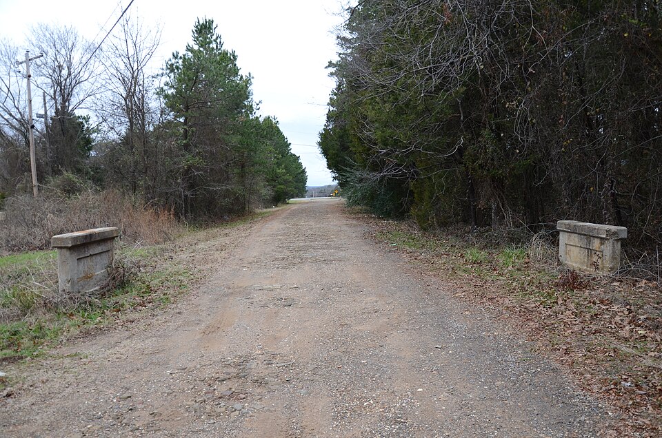
Listed on the National Register of Historic Places in 2010.
One of 22 National Register listings published here for Franklin County · listed in 2010 · category: Structure.
Sources: the National Register database, National Park Service
Regional context, not property-specific evidence. The federal wildfire occurrence database lists 53 fires within 5 miles of Johnson County Line-Ozark-Crawford County Line Road, Altus Segment between 2000 and 2019, burning about 374 acres in total. 5 started naturally. 7 were recorded as arson. Distance is straight-line from the map coordinates, so a fire counted here may appear on a neighbouring settlement's page as well.
| Reported cause | Fires |
|---|---|
| Missing data/not specified/undetermined | 21 |
| Debris and open burning | 14 |
| Arson/incendiarism | 7 |
| Natural | 5 |
| Misuse of fire by a minor | 4 |
| Smoking | 1 |
| Equipment and vehicle use | 1 |
The most recent of them, most recent first, with the day each was reported and the service that recorded it.
| Date | Cause | Size | Reported by | Name on the report |
|---|---|---|---|---|
| 6 September 2001 | Debris and open burning | 2.0 acres | Arkansas Forestry Commission | not named |
| 30 September 2005 | Natural | 15 acres | Arkansas Forestry Commission | not named |
| 3 September 2000 | Arson/incendiarism | 3.0 acres | Arkansas Forestry Commission | not named |
| 18 September 2011 | Missing data/not specified/undetermined | under an acre | Arkansas Forestry Commission | not named |
| 16 September 2000 | Missing data/not specified/undetermined | 9.0 acres | Arkansas Forestry Commission | not named |
| 12 September 2012 | Debris and open burning | 95 acres | Arkansas Forestry Commission | not named |
| 12 September 2005 | Missing data/not specified/undetermined | 1.0 acres | Arkansas Forestry Commission | not named |
| 7 August 2011 | Misuse of fire by a minor | 3.0 acres | Arkansas Forestry Commission | not named |
Regional context, not property-specific evidence. The federal mineral resources record lists 13 workings within 5 miles of Johnson County Line-Ozark-Crawford County Line Road, Altus Segment: 12 past producers, 1 producer. 1 still produces. What was taken out: Sand and Gravel, Construction, Stone, Flagstone. Distance is straight-line from the map coordinates, so a quarry counted here may appear on a neighbouring settlement's page as well.
| Where | Site | Commodity | Status | Recorded |
|---|---|---|---|---|
| Chrisman Rock Quarry | Flagstone | Past Producer | ||
| Unk | Stone | Past Producer | ||
| Gutrie Island | Sand and Gravel, Construction | Producer | ||
| Unk | Sand and Gravel, Construction | Past Producer | ||
| Unk | Sand and Gravel, Construction | Past Producer | ||
| Unk | Sand and Gravel, Construction | Past Producer | ||
| Unk | Sand and Gravel, Construction | Past Producer | ||
| Unk | Sand and Gravel, Construction | Past Producer | ||
| Unk | Sand and Gravel, Construction | Past Producer | ||
| Unk | Sand and Gravel, Construction | Past Producer |
Regional context, not property-specific evidence. The National Weather Service names Altus, the town this property stands in, in 53 storm reports between 1994 and 2024: 31 thunderstorm wind, 17 hail, 2 tornado, 1 funnel cloud. The reports record 1 injury. Each account below is quoted exactly as the forecast office filed it, from the NOAA Storm Events Database, and each date opens the federal record of that event.
| When | Event | Place named | Harm | What the report says |
|---|---|---|---|---|
| August 2006 | Lightning | Altus | 1 hurt | A 59 year old man was struck by lightning in the yard of his home. |
| November 2001 | Tornado (F1) | Altus | $2,000,000 | An F1 tornado touched down 1 mile west of Altus and crossed the Johnson County border 6 miles northeast of Altus. The tornado first began doing damage just southwest of Highway 64. The strongest intensity began just south of Interstate 40, just east of Wiederkerh Village and continued across Interstate 40 into Philpott Valley where most of the property damage occurred. The tornado resulted in F1 damage to several houses. Several mobile homes, numerous barns, outbuildings, and other weaker structures were destroyed, including two long turkey houses. |
| July 2022 | Thunderstorm Wind | Altus | $50,000 | Strong thunderstorm wind damaged several outbuildings, damaged the roof of a home, damaged the roof of a school, and blew down trees. |
| April 2021 | Hail | Altus | $25,000 | Golf ball size hail damaged vehicles and homes in Denning. |
| January 2000 | Thunderstorm Wind | Altus | $20,000 | Thunderstorm winds rolled a mobile home over and blew down several trees. |
| April 2017 | Hail | Altus | $15,000 | no account filed |
| June 2014 | Thunderstorm Wind | Altus | $10,000 | Strong thunderstorm wind blew down a large tree onto a car. The car's occupant was trapped inside and needed to be rescued by first responders but was uninjured. |
| November 2001 | Tornado (F0) | Altus | $10,000 | A F0 tornado touched down 2 miles northeast of Altus and crossed into Johnson County 5 miles northeast of Altus. The tornado did tree damage, caused minor damage to a few homes and also blew down power lines. |
| November 2001 | Thunderstorm Wind | Altus | $10,000 | Thunderstorm winds estimated at 60 miles an hour by a trained spotter blew a truck over on Interstate 40. |
| June 2024 | Thunderstorm Wind | Altus | $5,000 | Strong thunderstorm wind damaged an outbuilding. |
| October 2018 | Thunderstorm Wind | Altus | $5,000 | Strong thunderstorm wind damaged a home and blew down a few trees. |
| October 2014 | Thunderstorm Wind | Altus | $5,000 | Strong thunderstorm wind blew down power lines and a tree onto a house. |
| May 2013 | Thunderstorm Wind | Altus | $5,000 | A few trees and power lines were blown down by strong thunderstorm winds. |
| August 2013 | Thunderstorm Wind | Altus | $5,000 | Strong thunderstorm wind blew down a few trees and snapped power lines on Highway 186 north of Altus. |
| August 2013 | Thunderstorm Wind | Altus | $5,000 | Strong thunderstorm wind blew down power lines in Denning. |
| May 2011 | Thunderstorm Wind | Altus | $5,000 | Strong thunderstorm wind blew down trees and power lines in the Denning area. |
| August 2011 | Thunderstorm Wind | Altus | $5,000 | Strong thunderstorm wind blew down large tree limbs and damaged the roof of a new mobile home. |
| October 2007 | Thunderstorm Wind | Altus | $5,000 | Thunderstorm winds estimated at 60 miles an hour blew down power lines causing power outages. |
| March 2006 | Thunderstorm Wind | Altus | $5,000 | Thunderstorm winds estimated at 70 miles an hour blew down trees and signs, and also damaged a building. |
| June 1999 | Thunderstorm Wind | Altus | $2,500 | Numerous power lines and trees were blown down in Altus. |
| June 2023 | Thunderstorm Wind | Altus | $2,000 | Strong thunderstorm wind blew down power lines. |
| April 2015 | Thunderstorm Wind | Altus | $2,000 | Strong thunderstorm wind blew down power lines south of Highway 64 on Logan Street, and on Highway 179. |
| November 1998 | Thunderstorm Wind | Altus | $1,000 | Trees were blown onto a power line between Ozark and Coal Hill, causing a power outage to a large part of western Johnson County. |
| June 1998 | Thunderstorm Wind | Altus | $500 | Several trees (3 ft. diameter) were blown down in Altus. One tree was blown onto a street, blocking the roadway. |
| January 2000 | Thunderstorm Wind | Altus | $300 | Thunderstorm winds blew down trees. |
| August 2024 | Thunderstorm Wind | Altus | - | Strong thunderstorm wind blew down numerous trees. |
| May 2019 | Thunderstorm Wind | Altus | - | Strong thunderstorm wind snapped and uprooted numerous trees north of town. Saint Mary's Lane was covered in downed trees from just north of town up to the church. |
| March 2015 | Thunderstorm Wind | Altus | - | Strong thunderstorm wind blew down trees on Highway 64 between Altus and Ozark. |
| July 2014 | Flash Flood | Altus | - | Locally heavy rainfall of around 5 inches in several hours resulted in the flooding of several county roads near and around Altus. |
| June 2014 | Thunderstorm Wind | Altus | - | Strong thunderstorm wind blew down a large tree. |
| October 2014 | Thunderstorm Wind | Altus | - | Strong thunderstorm wind blew down several trees across Highway 64. |
| June 2011 | Thunderstorm Wind | Altus | - | Trees were blown down by strong thunderstorm winds. |
| April 2008 | Thunderstorm Wind | Altus | - | Thunderstorm winds estimated at 70 miles an hour blew down numerous trees. |
| April 2008 | Thunderstorm Wind | Altus | - | Thunderstorm winds estimated at 60 miles an hour blew down numerous large tree limbs. |
| July 2006 | Thunderstorm Wind | Altus | - | Strong thunderstorm wind blew down trees. |
| November 2001 | Thunderstorm Wind | Altus | - | Thunderstorm winds estimated at 70 miles an hour blew a few trees down. |
| March 1999 | Hail | Altus | - | Location: Wiederkehr Winery Restaurant...no damage |
| April 2021 | Hail | Altus | - | no account filed |
| April 2009 | Hail | Altus | - | no account filed |
| April 2008 | Hail | Altus | - | no account filed |
| March 2008 | Hail | Altus | - | no account filed |
| February 2008 | Hail | Altus | - | no account filed |
| April 2005 | Hail | Altus | - | no account filed |
| April 2005 | Hail | Altus | - | no account filed |
| April 2005 | Hail | Altus | - | no account filed |
| April 2005 | Hail | Altus | - | no account filed |
| November 2001 | Hail | Altus | - | no account filed |
| November 2001 | Hail | Altus | - | no account filed |
| March 1999 | Funnel Cloud | Altus | - | no account filed |
| April 1999 | Thunderstorm Wind | Altus | - | no account filed |
| January 1999 | Hail | Altus | - | no account filed |
| May 1998 | Hail | Altus | - | no account filed |
| June 1994 | Hail | Altus | - | no account filed |
No historic map-sheet match is published for this property yet. That does not mean no map exists. This record needs a coordinate-quality review before it can be joined to a sheet boundary. Browse the county's mapped places while that work is pending.
Other National Register properties close enough to walk or drive between, ordered by distance from this one. Both positions come from the same geocoding pass that matched these properties to their map sheets.
| Photograph | Property | Distance | Listed |
|---|---|---|---|
 | Our Lady of Perpetual Help Church | 2.1 miles | 1976 |
 | Missouri-Pacific Depot-Altus | 2.3 miles | 1992 |
 | German-American Bank | 2.3 miles | 1990 |
 | Altus Well Shed-Gazebo | 2.3 miles | 1996 |
 | Merle Whitman Tourist Cabin | 2.4 miles | 2006 |
 | Missouri-Pacific Depot-Ozark | 2.5 miles | 1992 |
| National Archives record | The nomination case file for reference 10000033 in Record Group 79. |
| Franklin County | All 22 listed properties in this county. |