BlockBefore
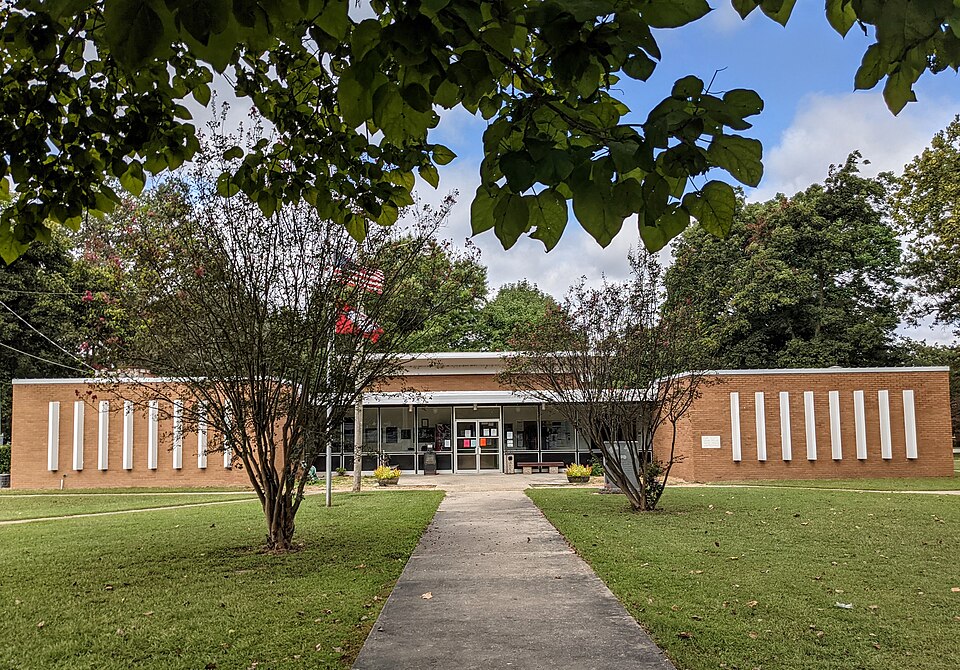
Photograph of Clay County Courthouse, Western District
Photograph by Colinhester, CC BY-SA 4.0. Via Wikimedia Commons.

Clay County Courthouse, Western District

Built in 1966 (New Formalism). Listed on the National Register of Historic Places in 2018.

From the record

“The Clay County Courthouse, Western District is located at Courthouse Square in the center of Corning, one of two county seats of Clay County, Arkansas. It is a single-story masonry structure, built out of concrete with brick facing.”

Wikipedia article Clay County Courthouse, Western District, CC BY-SA 4.0.

One of 19 National Register listings published here for Clay County · listed in 2018 · category: Building · built in 1966, New Formalism.

Sources: the Wikipedia article · the National Register database, National Park Service · the Wikipedia article
The listing

  • What is counted as historic. The nomination lists 1 building as contributing to the listing.
  • Address. 800 W 2nd St., Corning, 72422
  • When was it listed? September 2018
  • Category. building
  • Township. Gleghorn-South Kilgore township
  • When was it built? 1966
  • Architectural style. New Formalism
  • National Register reference number. 100002946 - assigned by the National Park Service when the property was listed.

Mines and quarries near this property

2 within 5 miles

Regional context, not property-specific evidence. The federal mineral resources record lists 2 workings within 5 miles of Clay County Courthouse, Western District: 2 past producers. None of them still produces. What was taken out: Sand and Gravel, Construction. Distance is straight-line from the map coordinates, so a quarry counted here may appear on a neighbouring settlement's page as well.

Where SiteCommodity StatusRecorded
C Thomas PitSand and Gravel, ConstructionPast Producer
R Mulholen PitSand and Gravel, ConstructionPast Producer

Every working recorded in Clay County

Storms near this property

60 of 66 shown

Regional context, not property-specific evidence. The National Weather Service names Corning, the town this property stands in, in 66 storm reports between 1993 and 2026: 28 thunderstorm wind, 28 hail, 8 flash flood, 1 flood. No death or injury is recorded in these reports. Each account below is quoted exactly as the forecast office filed it, from the NOAA Storm Events Database, and each date opens the federal record of that event.

WhenEvent Place namedHarm What the report says
November 1993Thunderstorm WindCorning$500,000Thunderstorm winds blew down numerous trees. A number of buildings were damaged and several were destroyed.
June 2001HailCorning$400,000Numerous homes and automobiles were damaged by hail.
December 2015Flash FloodCorning$50,000Heavy rain resulting in flash flooding in the Corning area. Neighborhoods were flooded and cars stalled.
August 2019Thunderstorm WindCorning$30,000Trees and power-lines down in the community of Corning.
September 2006Thunderstorm WindCorning$30,000Straight line winds blew down several trees in Corning, some of which fell on homes. In addition, roofs were blown from homes and buildings.
February 1999Thunderstorm WindCorning$25,000At least one home and several businesses lost part of their roofs. Several sheds were damaged. Several trees and power lines were blown down.
February 2023Thunderstorm WindCorning$20,000Several power poles were knocked down on both sides of Highway 67 just west of Corning. A portable storage building was also blown down.
May 2021Thunderstorm WindCorning$15,000Straight-line winds tore the siding off a home in Corning and knocked numerous trees down.
July 2003Thunderstorm WindCorning$15,000A few buildings had roof damage. Several trees were blown down.
January 1999Thunderstorm WindCorning$15,000A log cabin and barn were destroyed. A satellite receiver was also demolished. One home sustained damage to shingles on the roof. Several power poles and trees were also knocked down.
June 1998Thunderstorm WindCorning$15,000A building lost its roof. Several trees and power lines were knocked down.
May 2019Thunderstorm WindCorning$10,000Wind damage to High School. Mainly roof problems.
September 2006Flash FloodCorning$10,000Flash flooding caused many county roads to go underneath water near Corning. Flood waters were also entering houses.
July 2004Thunderstorm WindCorning$10,000Several trees and power lines were blown down.
May 2022Thunderstorm WindCorning$5,000Trees and powerlines down in Corning.
May 2020Thunderstorm WindCorning$5,000Utility pole snapped along County Road 140.
April 1999Thunderstorm WindCorning$5,000An old barn was blown down. Several trees and a flag pole were also blown down.
September 2006HailCorning$5,000no account filed
July 1995HailCorning$5,000no account filed
April 2006HailCorning$2,500no account filed
May 2019Thunderstorm WindCorning$2,000Large limbs down and minor shingle damage.
April 2008Thunderstorm WindCorning$2,000Straight line winds blew trees down on Second Street in Corning.
April 2007HailCorning$2,000Quarter to golfball size hail fell in the Corning area.
March 1996Thunderstorm WindCorning$2,000no account filed
August 2007Thunderstorm WindCorning$1,500Straight line winds knocked down a few power lines 1 mile east of Corning.
March 2022Thunderstorm WindCorning$1,000Telephone pole down near S&L Irrigation.
September 2001Flash FloodCorning$1,000Several highways had water covering them after over 6 inches of rain fell in Clay county in a few hours. The flooding produced widespread damage to the rice crop in the area.
January 2000FloodCorning$1,000A few streets were flooded in the town of Corning.
May 1995Thunderstorm WindCorning$1,000Several trees were knocked down.
June 2001HailCorning$750no account filed
August 2000HailCorning$750no account filed
October 1996Thunderstorm WindCorning$500no account filed
April 2000HailCorning$350Hail ranged in size from quarter to half dollar.
July 2003HailCorning$10no account filed
April 2000HailCorning$10no account filed
June 1999HailCorning$10no account filed
March 2026Thunderstorm WindCorning-A private weather station reported a 67 mph gust near the Corning airport.
March 2025HailCorning-Half dollar sized hail.
March 2025HailCorning-Golf ball to egg sized hail.
April 2025Flash FloodCorning-Portions of AR HWY 62 were closed due to high water.
May 2024Thunderstorm WindCorning-A tree was downed and blocking a road in Corning.
February 2022Thunderstorm WindCorning-Several trees were knocked down on roads and a house.
May 2020Thunderstorm WindCorning-A tree was knocked down on power lines on SW 3rd Street in Corning.
September 2012HailCorning-Multiple reports of quarter size hail in Corning.
September 2012Tornado (EF0)Corning-A tornado briefly touched down in a farm field near the intersection of County Road 147 and Highway 67, northeast of Corning.
February 2011Flash FloodCorning-Heavy rain produced flash flooding in Corning. Flooding closed 3rd Street, Laurel Street and Crafton Street. Some sandbagging was necessary to keep water out of homes.
May 2009Flash FloodCorning-Heavy rain produced flash flooding in and around Corning. A couple of city streets were flooded as a result.
July 2009Flash FloodCorning-Heavy rain produced flash flooding in the low lying areas around Corning.
April 2007Flash FloodCorning-Heavy rain caused streets to become flooded in Corning.
July 2006Thunderstorm WindCorning-A trained spotter measured a thunderstorm wind gust of 60 mph.
April 2026HailCorning-no account filed
May 2025HailCorning-no account filed
May 2024HailCorning-no account filed
April 2023HailCorning-no account filed
July 2023HailCorning-no account filed
June 2023HailCorning-no account filed
April 2015HailCorning-no account filed
June 2011HailCorning-no account filed

Every storm recorded in Clay County

Map coverage status

No historic map-sheet match is published for this property yet. That does not mean no map exists. This record needs a coordinate-quality review before it can be joined to a sheet boundary. Browse the county's mapped places while that work is pending.

Listed places nearby

3 within 8 miles

Other National Register properties close enough to walk or drive between, ordered by distance from this one. Both positions come from the same geocoding pass that matched these properties to their map sheets.

Photograph PropertyDistance Listed
Sheeks Houseunder 500 feet1975
Oliver House0.5 miles1978
Sink-Crumb Post No. 72 American Legion Hut5.8 miles2008

Sources for this property

National Archives recordThe nomination case file for reference 100002946 in Record Group 79.
Wikipedia articleCommunity-written account of this property, licensed CC BY-SA.
Clay CountyAll 19 listed properties in this county.

Provenance

  • Listing record. National Park Service National Register of Historic Places, listed-properties dataset, current to 2026-05-22.
  • Map join. Address geocoded through the United States Census geocoder, then tested against the published boundary of every sheet in the USGS Historical Topographic Map Collection.
  • How this page is made. Listing fields come from federal records; map-sheet coverage is a labelled coordinate-to-boundary calculation, not a source-field claim.
  • Mines and quarries. USGS Mineral Resources Data System (MRDS) https://mrdata.usgs.gov/mrds/ A work of the United States government, no copyright under 17 U.S.C. 105.
  • Storms. NOAA National Centers for Environmental Information, Storm Events Database https://www.ncei.noaa.gov/stormevents/ A work of the United States government, no copyright under 17 U.S.C. 105. Narratives are quoted verbatim from the National Weather Service report and are not edited or summarised.