 Block
From the record
One of 27 National Register listings published here for Hot Spring County · listed in 2023 · category: Building.
Sources: the National Register database, National Park Service
Listed on the National Register of Historic Places in 2023.
One of 27 National Register listings published here for Hot Spring County · listed in 2023 · category: Building.
Sources: the National Register database, National Park Service
Regional context, not property-specific evidence. The federal wildfire occurrence database lists 161 fires within 5 miles of Garrett's Grocery Store between 1997 and 2019, burning about 1,064 acres in total. 10 started naturally. 40 were recorded as arson. Distance is straight-line from the map coordinates, so a fire counted here may appear on a neighbouring settlement's page as well.
| Reported cause | Fires |
|---|---|
| Debris and open burning | 50 |
| Arson/incendiarism | 40 |
| Missing data/not specified/undetermined | 31 |
| Equipment and vehicle use | 21 |
| Natural | 10 |
| Smoking | 6 |
| Misuse of fire by a minor | 3 |
The most recent of them, most recent first, with the day each was reported and the service that recorded it.
| Date | Cause | Size | Reported by | Name on the report |
|---|---|---|---|---|
| 9 September 2013 | Missing data/not specified/undetermined | 1.0 acres | Arkansas Forestry Commission | not named |
| 8 September 2013 | Missing data/not specified/undetermined | 2.0 acres | Arkansas Forestry Commission | not named |
| 8 September 2013 | Missing data/not specified/undetermined | 3.0 acres | Arkansas Forestry Commission | not named |
| 8 September 2013 | Missing data/not specified/undetermined | 1.0 acres | Arkansas Forestry Commission | not named |
| 8 September 2013 | Missing data/not specified/undetermined | 2.0 acres | Arkansas Forestry Commission | not named |
| 8 September 2004 | Debris and open burning | 1.0 acres | Arkansas Forestry Commission | not named |
| 7 September 2012 | Arson/incendiarism | 60 acres | Arkansas Forestry Commission | not named |
| 7 September 2009 | Natural | 3.0 acres | Arkansas Forestry Commission | not named |
Regional context, not property-specific evidence. The federal mineral resources record lists 16 workings within 5 miles of Garrett's Grocery Store: 12 unknowns, 4 producers. 4 still produce. What was taken out: Sand and Gravel, Construction, Stone, Crushed/Broken. Distance is straight-line from the map coordinates, so a quarry counted here may appear on a neighbouring settlement's page as well.
| Where | Site | Commodity | Status | Recorded |
|---|---|---|---|---|
| Caddo Quarry | Stone, Crushed/Broken | Producer | ||
| Murray Quarry & Mill | Stone, Crushed/Broken | Producer | ||
| Cook Brothers Pit & Plant | Sand and Gravel, Construction | Producer | ||
| Deroche Creek Quarry | Sand and Gravel, Construction | Producer | ||
| Unk | Sand and Gravel, Construction | Unknown | ||
| Unk | Sand and Gravel, Construction | Unknown | ||
| Unk | Sand and Gravel, Construction | Unknown | ||
| Unk | Sand and Gravel, Construction | Unknown | ||
| Unk | Sand and Gravel, Construction | Unknown | ||
| Unk | Sand and Gravel, Construction | Unknown |
Regional context, not property-specific evidence. The National Weather Service names Friendship, the town this property stands in, in 17 storm reports between 1994 and 2024: 7 thunderstorm wind, 6 hail, 3 tornado, 1 heavy rain. The reports record 11 injuries. Each account below is quoted exactly as the forecast office filed it, from the NOAA Storm Events Database, and each date opens the federal record of that event.
| When | Event | Place named | Harm | What the report says |
|---|---|---|---|---|
| March 1997 | Tornado (F4) | Friendship | 11 hurt, $2,000,000 | no account filed |
| April 2011 | Thunderstorm Wind | Friendship | $40,000 | Some houses were damaged in the Friendship area. |
| July 2009 | Thunderstorm Wind | Friendship | $2,000 | A large tree was down over Interstate 30 near mile marker 83. |
| April 2024 | Hail | Friendship | - | Penny-sized hail fell in the community of Friendship. |
| August 2024 | Hail | Friendship | - | Nickel sized hail fell in the community of Friendship. |
| September 2013 | Heavy Rain | Friendship | - | During the morning of the 21st, trees fell in two different places on Arkansas 84 east of Bismarck, blocking the highway. Then, early in the evening, a tree fell on the westbound lanes of Interstate 30 about 3 miles northeast of Friendship. The tree blocked the highway. One car ran into the fallen tree, but no one was injured. Then, a two-car accident occurred, but once again, there were no injuries. Rainfall measured 3.10 inches at Malvern. |
| June 2004 | Thunderstorm Wind | Friendship | - | Several trees were knocked down around Friendship. |
| December 1999 | Tornado (F1) | Friendship | - | A weak tornado was spawned in Hot Spring County. The tornado developed around 2 miles southeast of Friendship and caused mostly tree damage. Hundreds of trees were either snapped or twisted. The tornado crossed U.S. Highway 67 at the Ouachita River bridge and destroyed a barn and damaged the back porch of a house in the area. The tornado dissipated about 2 miles northwest of Donaldson. |
| April 1998 | Thunderstorm Wind | Friendship | - | Several trees were knocked down. |
| July 1995 | Thunderstorm Wind | Friendship | - | Thunderstorm winds blew down some large tree limbs. |
| March 2016 | Hail | Friendship | - | no account filed |
| June 2009 | Hail | Friendship | - | no account filed |
| April 2002 | Hail | Friendship | - | no account filed |
| May 2000 | Thunderstorm Wind | Friendship | - | no account filed |
| March 1999 | Tornado (F2) | Friendship | - | no account filed |
| June 1998 | Thunderstorm Wind | Friendship | - | no account filed |
| May 1994 | Hail | Friendship | - | no account filed |
No historic map-sheet match is published for this property yet. That does not mean no map exists. This record needs a coordinate-quality review before it can be joined to a sheet boundary. Browse the county's mapped places while that work is pending.
Other National Register properties close enough to walk or drive between, ordered by distance from this one. Both positions come from the same geocoding pass that matched these properties to their map sheets.
| Photograph | Property | Distance | Listed |
|---|---|---|---|
| Morrison Plantation Smokehouse | 4.5 miles | 1977 | |
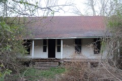 | Blakely House | 7.8 miles | 1976 |
| National Archives record | The nomination case file for reference 100008561 in Record Group 79. |
| Hot Spring County | All 27 listed properties in this county. |