 Block
From the record
One of 15 National Register listings published here for Cleveland County · listed in 1976 · category: Building.
Sources: the National Register database, National Park Service · the Wikipedia article
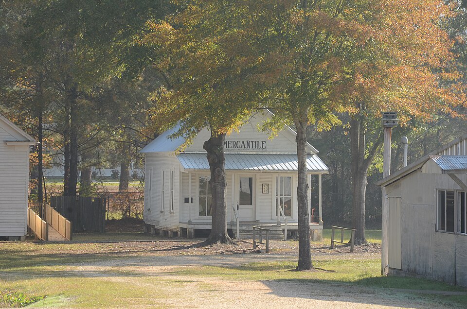
Listed on the National Register of Historic Places in 1976.
One of 15 National Register listings published here for Cleveland County · listed in 1976 · category: Building.
Sources: the National Register database, National Park Service · the Wikipedia article
Regional context, not property-specific evidence. The federal wildfire occurrence database lists 56 fires within 5 miles of Cleveland County Clerk's Building between 2001 and 2020, burning about 234 acres in total. 1 started naturally. 1 was recorded as arson. Distance is straight-line from the map coordinates, so a fire counted here may appear on a neighbouring settlement's page as well.
| Reported cause | Fires |
|---|---|
| Missing data/not specified/undetermined | 29 |
| Debris and open burning | 18 |
| Railroad operations and maintenance | 2 |
| Equipment and vehicle use | 2 |
| Natural | 1 |
| Misuse of fire by a minor | 1 |
| Recreation and ceremony | 1 |
| Arson/incendiarism | 1 |
| Smoking | 1 |
The most recent of them, most recent first, with the day each was reported and the service that recorded it.
| Date | Cause | Size | Reported by | Name on the report |
|---|---|---|---|---|
| 8 September 2013 | Missing data/not specified/undetermined | 1.0 acres | Arkansas Forestry Commission | not named |
| 30 September 2019 | Missing data/not specified/undetermined | 13 acres | Arkansas Forestry Commission | not named |
| 22 September 2015 | Debris and open burning | 3.0 acres | Arkansas Forestry Commission | not named |
| 21 September 2015 | Debris and open burning | 10 acres | Arkansas Forestry Commission | not named |
| 21 September 2007 | Railroad operations and maintenance | 1.0 acres | Arkansas Forestry Commission | not named |
| 2 September 2013 | Missing data/not specified/undetermined | 15 acres | Arkansas Forestry Commission | not named |
| 12 September 2006 | Debris and open burning | 10 acres | Arkansas Forestry Commission | not named |
| 8 August 2011 | Natural | 4.0 acres | Arkansas Forestry Commission | not named |
Regional context, not property-specific evidence. The federal mineral resources record lists 32 workings within 5 miles of Cleveland County Clerk's Building: 29 past producers, 2 producers, 1 unknown. 2 still produce. What was taken out: Sand and Gravel, Construction, Iron. Distance is straight-line from the map coordinates, so a quarry counted here may appear on a neighbouring settlement's page as well.
| Where | Site | Commodity | Status | Recorded |
|---|---|---|---|---|
| Rison | Iron | Unknown | ||
| Cleveland County Pit | Sand and Gravel, Construction | Producer | ||
| Cleveland County Pit | Sand and Gravel, Construction | Producer | ||
| Frank & Grady Wilson Pit | Sand and Gravel, Construction | Past Producer | ||
| Unk | Sand and Gravel, Construction | Past Producer | ||
| Unk | Sand and Gravel, Construction | Past Producer | ||
| Unk | Sand and Gravel, Construction | Past Producer | ||
| Unk | Sand and Gravel, Construction | Past Producer | ||
| Unk | Sand and Gravel, Construction | Past Producer | ||
| Unk | Sand and Gravel, Construction | Past Producer |
Regional context, not property-specific evidence. The National Weather Service names Rison, the town this property stands in, in 72 storm reports between 1994 and 2025: 41 thunderstorm wind, 26 hail, 4 flash flood, 1 lightning. No death or injury is recorded in these reports. Each account below is quoted exactly as the forecast office filed it, from the NOAA Storm Events Database, and each date opens the federal record of that event.
| When | Event | Place named | Harm | What the report says |
|---|---|---|---|---|
| July 2016 | Thunderstorm Wind | Rison | $200,000 | Numerous chicken houses were damaged in the Rison area. |
| October 2009 | Thunderstorm Wind | Rison | $150,000 | Trees and power lines were down. Several houses in the area sustained roof damage, and several chicken houses had their roofs torn off. |
| July 2016 | Thunderstorm Wind | Rison | $100,000 | Over 100 reports of trees and power lines down near Rison and across Cleveland County. |
| April 2022 | Thunderstorm Wind | Rison | $50,000 | Several trees fell on a mobile home, resulting in one fatality. |
| March 2007 | Thunderstorm Wind | Rison | $50,000 | On U.S. 79, much of the tin roof was torn off the waste transfer station. On Niven Road, about three dozen large trees were blown down. Four mobile homes were damaged by the falling trees. One trailer, which was vacant, had a tree slice all the way through it. Two of the trailers were occupied, but there were no injuries. Power lines were knocked down by the falling trees. On Adams Road, a porch roof was blown off and a pine tree about 20 inches in diameter fell, taking down a power line. |
| November 1994 | Thunderstorm Wind | Rison | $50,000 | Thunderstorm winds downed some trees. A tree also fell onto a house causing roof damage. |
| April 2011 | Thunderstorm Wind | Rison | $25,000 | Trees and power lines were blown down onto roads around Rison. |
| May 2009 | Thunderstorm Wind | Rison | $25,000 | Trees blocked roadways and knocked down power lines in the area. An oak tree fell across Arkansas Highway 35 South at Rison blocking both lanes of traffic. A large pine tree fell in a resident's yard on Arkansas Highway 133 north of Rison, breaking an underground water line. |
| June 2012 | Thunderstorm Wind | Rison | $20,000 | Many power lines were reported down in Rison. This caused many people to lose power throughout the town. |
| April 2011 | Thunderstorm Wind | Rison | $20,000 | Trees and power lines were blown down. |
| July 2007 | Flash Flood | Rison | $20,000 | Flooding was reported on several city streets. County roads and Arkansas Highway 35 South were flooded. Major damage was reported to Brushy Creek Road, Jack White Road and Tom Taylor Road. |
| July 2010 | Lightning | Rison | $15,000 | Lightning struck a transformer in Rison, knocking out power to the downtown area and much of the city. |
| July 2009 | Thunderstorm Wind | Rison | $15,000 | Trees and power lines were down in Rison. |
| March 1997 | Thunderstorm Wind | Rison | $7,000 | no account filed |
| April 2011 | Thunderstorm Wind | Rison | $5,000 | Trees were blown down. |
| March 1997 | Thunderstorm Wind | Rison | $3,000 | no account filed |
| April 2025 | Thunderstorm Wind | Rison | - | Multiple trees were blow over and roof damage occurred in the community of Rison. |
| April 2025 | Thunderstorm Wind | Rison | - | Multiple trees were blown down in Rison along with roof damage to several buildings within the town. |
| March 2023 | Thunderstorm Wind | Rison | - | A metal outbuilding was destroyed. |
| March 2023 | Thunderstorm Wind | Rison | - | Numerous large trees were blown down southwest of Rison. |
| March 2023 | Hail | Rison | - | A carport was also reported blown over. The report was received through social media. |
| March 2023 | Thunderstorm Wind | Rison | - | The NWS storm damage survey revealed 85 mph thunderstorm winds produced damage in a swath across the city of Rison Wednesday evening. The time is radar estimated. |
| April 2020 | Thunderstorm Wind | Rison | - | Widespread damage occurred across the county with numerous trees and power lines down. Some roads in the county were blocked due to the extent of the downed trees. |
| May 2019 | Thunderstorm Wind | Rison | - | A tree was blown down. |
| August 2018 | Thunderstorm Wind | Rison | - | Trees and power lines were blown down at multiple locations across the county. |
| June 2006 | Thunderstorm Wind | Rison | - | A large tree was blown down onto a power line. |
| May 2004 | Thunderstorm Wind | Rison | - | Thunderstorm winds downed numerous trees within a 10 mile radius of Rison. |
| April 2003 | Thunderstorm Wind | Rison | - | Several trees were knocked down. |
| June 2003 | Flash Flood | Rison | - | Street flooding was reported in Rison. |
| June 2003 | Flash Flood | Rison | - | Heavy rains resulted in flash flooding near Rison. Several streets were impassible for a few hours due to high water. |
| July 2002 | Thunderstorm Wind | Rison | - | A large tree was blown down. |
| July 2002 | Thunderstorm Wind | Rison | - | Several large trees were knocked down. |
| May 2001 | Thunderstorm Wind | Rison | - | Thunderstorm winds blew down some trees. |
| June 2001 | Thunderstorm Wind | Rison | - | Thunderstorm winds damaged the roofs of several buildings in Rison. |
| May 2001 | Thunderstorm Wind | Rison | - | Trees and power lines were knocked down. |
| November 1995 | Thunderstorm Wind | Rison | - | Trees and power lines were downed. |
| February 2024 | Hail | Rison | - | no account filed |
| April 2015 | Hail | Rison | - | no account filed |
| March 2014 | Hail | Rison | - | no account filed |
| February 2013 | Hail | Rison | - | no account filed |
| April 2013 | Hail | Rison | - | no account filed |
| March 2011 | Hail | Rison | - | no account filed |
| May 2011 | Hail | Rison | - | no account filed |
| February 2009 | Hail | Rison | - | no account filed |
| April 2006 | Hail | Rison | - | no account filed |
| May 2006 | Thunderstorm Wind | Rison | - | no account filed |
| June 2004 | Hail | Rison | - | no account filed |
| June 2004 | Hail | Rison | - | no account filed |
| June 2004 | Hail | Rison | - | no account filed |
| May 2003 | Hail | Rison | - | no account filed |
| July 2002 | Hail | Rison | - | no account filed |
| July 2002 | Hail | Rison | - | no account filed |
| May 2001 | Hail | Rison | - | no account filed |
| May 2001 | Hail | Rison | - | no account filed |
| February 2000 | Thunderstorm Wind | Rison | - | no account filed |
| May 2000 | Thunderstorm Wind | Rison | - | no account filed |
| May 2000 | Thunderstorm Wind | Rison | - | no account filed |
| July 2000 | Thunderstorm Wind | Rison | - | no account filed |
| February 1999 | Hail | Rison | - | no account filed |
| May 1999 | Hail | Rison | - | no account filed |
No historic map-sheet match is published for this property yet. That does not mean no map exists. This record needs a coordinate-quality review before it can be joined to a sheet boundary. Browse the county's mapped places while that work is pending.
Other National Register properties close enough to walk or drive between, ordered by distance from this one. Both positions come from the same geocoding pass that matched these properties to their map sheets.
| Photograph | Property | Distance | Listed |
|---|---|---|---|
 | Mount Olivet Methodist Church | under 500 feet | 1975 |
| Rison Overpass | 0.3 miles | 2021 | |
 | Rison Cities Service Station | 0.4 miles | 2001 |
 | Rison Texaco Service Station | 0.4 miles | 2002 |
| Phoenix Hotel | 0.5 miles | 2002 | |
 | Cleveland County Courthouse | 0.6 miles | 1977 |
| National Archives record | The nomination case file for reference 76000394 in Record Group 79. |
| Wikipedia article | Community-written account of this property, licensed CC BY-SA. |
| Cleveland County | All 15 listed properties in this county. |