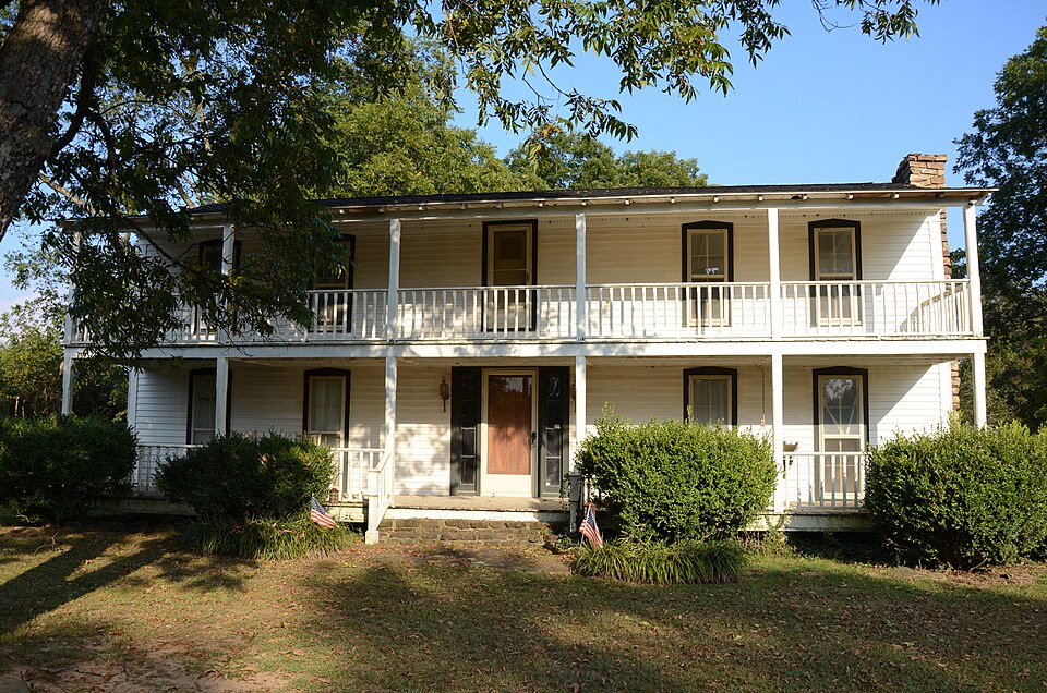
Listed on the National Register of Historic Places in 1978.
From the record
“The Morris House is a historic house in rural White County, Arkansas. It is located northwest of Bradford, near the junction of Morris Drive and Jerry Smith Road.”
Wikipedia article Morris House (Bradford, Arkansas), CC BY-SA 4.0.
One of 203 National Register listings published here for White County · listed in 1978 · category: Building.
National Register reference number. 78000641 - assigned by the National Park Service when the property was listed.
Fires near this property
94 since 1997
Regional context, not property-specific
evidence. The
federal wildfire occurrence database
lists 94 fires within 5 miles of Morris House
between 1997 and 2019, burning about 1,807 acres in total. 2 started naturally. 32 were recorded as arson.
Distance is straight-line from the map coordinates, so a fire counted
here may appear on a neighbouring settlement's page as well.
Reported cause
Fires
Debris and open burning
37
Arson/incendiarism
32
Missing data/not specified/undetermined
16
Equipment and vehicle use
7
Natural
2
The most recent of
them, most recent first, with the day each was reported and the service
that recorded it.
Regional context, not property-specific
evidence. The federal mineral resources record lists
3 workings within 5 miles of Morris House: 3 past producers.
None of them still produces. What was taken out: Sand and Gravel, Construction, Stone. Distance is straight-line from the
map coordinates, so a quarry counted here may appear on a neighbouring
settlement's page as well.
Regional context, not property-specific
evidence. The National Weather Service names
Bradford, the town this property stands in, in 45 storm reports between 1998 and 2023: 16 hail, 14 thunderstorm wind, 9 flood, 3 flash flood.
No death or injury is recorded in these reports. Each account below is quoted exactly as the forecast office
filed it, from the NOAA Storm Events Database, and each date
opens the federal record of that event.
While minor river flooding was ongoing at the beginning of the month, the White River at the Augusta gage rose to highest levels since completion of the large flood control reservoirs in the mid twentieth century. Along the White River, about a dozen homes and recreational cabins flooded near Green Tom Lake and along the riverbank at U.S. Highway 64. Numerous county roads in the floodplain were inundated and some winter wheat was lost. The flooding in this reach of the White River continued into April.
Major flooding levels were repeated in April at the Augusta gage on the White River. Some homes and cabins were again flooded along U.S. Highway 64. The river crested slightly lower at Augusta in April than the crest in March, so damages were limited to whatever repairs were made between crests. This was the third highest crest since the flood control reservoirs were completed in the mid-twentieth century.
The roof was blown off a tractor shed, part of the roof was taken off a shop building, and the roof of a house was damaged. A number of large trees and power lines were blown down.
Heavy rainfall in March and April caused a prolonged high water event along the lower White River. Along the White County side of the floodplain within the Augusta reach of the river, high water delayed planting of cropland in the floodplain. The river did not recede below flood stage in this reach of the river until July, with the primary impact being the delayed planting of corn and rice, causing many farmers to switch to soybeans, and preventing the planting of many hundreds of acres that were either inundated or isolated by the high river stages. Some of this cropland, which lies below the flood stage, remained flooded into the summer months.
Reservoir releases from the upstream Corps of Engineers' lakes prolonged the high water event and kept the stage at Augusta above flood stage into the middle of the month. While the stage remained slightly above flood stage, farmers planted down to the water's edge. A brief period of higher stages during the week after the 4th of July holiday put water over several hundred acres of newly sprouted soybeans and killed the tender plants. Additional damages were noted.
Flood control releases from Bull Shoals and Norfork Dams in the upper White River basin caused minor flooding along the lower White River in the Augusta reach of the river. The river remained above flood stage throughout the month of June. Primary impact was to the row crop agricultural community with portions of the Taylor Bay bottoms flooded or isolated by high water. Dollar damages were reported in May totals.
Heavy rainfall from Tropical Depression Gustav created minor flooding along the White River. Approximately 2000 acres of soybeans were flooded and destroyed in the Augusta vicinity on the White County side of the river.
A strong tornado was spawned near Bradford and moved to the northeast. The tornado downed a number of trees which fell on residences in and near town. Some of the trees were quite old, and were likely at least 100 years old. The tornado tracked to about 1 mile north-northwest of town before heading into Jackson County.
A weak tornado touched down over northeast White County about 1 mile east of Bradford. The tornado downed a number of trees and power poles. Several homes sustained roof damage, mainly from falling trees. The tornado continued to track northeastward in Jackson County.
No historic map-sheet match is published
for this property yet. That does not mean no map exists. This record needs
a coordinate-quality review before it can be joined to a sheet boundary.
Browse the county's mapped places while that work is
pending.
Listed places nearby
6 within 8 miles
Other National Register properties close
enough to walk or drive between, ordered by distance from this one. Both
positions come from the same geocoding pass that matched these properties
to their map sheets.
Listing record. National Park Service National Register of Historic Places, listed-properties dataset, current to 2026-05-22.
Map join. Address geocoded through the United States Census geocoder, then tested against the published boundary of every sheet in the USGS Historical Topographic Map Collection.
How this page is made. Listing fields come from federal records; map-sheet coverage is a labelled coordinate-to-boundary calculation, not a source-field claim.
Wildfire. Short, Karen C. 2022. Spatial wildfire occurrence data for the United States, 1992-2020 [FPA_FOD_20221014]. 6th Edition. Fort Collins, CO: Forest Service Research Data Archive. https://doi.org/10.2737/RDS-2013-0009.6 Collected with United States Government funding and usable without additional permissions or fees.
Mines and quarries. USGS Mineral Resources Data System (MRDS) https://mrdata.usgs.gov/mrds/ A work of the United States government, no copyright under 17 U.S.C. 105.
Storms. NOAA National Centers for Environmental Information, Storm Events Database https://www.ncei.noaa.gov/stormevents/ A work of the United States government, no copyright under 17 U.S.C. 105. Narratives are quoted verbatim from the National Weather Service report and are not edited or summarised.
 Block