 Block
From the record
One of 40 National Register listings published here for Union County · listed in 1983 · category: Building.
Sources: the National Register database, National Park Service · the Wikipedia article
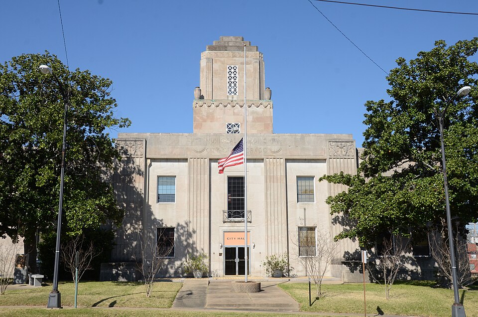
Listed on the National Register of Historic Places in 1983.
One of 40 National Register listings published here for Union County · listed in 1983 · category: Building.
Sources: the National Register database, National Park Service · the Wikipedia article
Regional context, not property-specific evidence. The federal wildfire occurrence database lists 127 fires within 5 miles of Municipal Building between 1997 and 2020, burning about 434 acres in total. 9 started naturally. 12 were recorded as arson. Distance is straight-line from the map coordinates, so a fire counted here may appear on a neighbouring settlement's page as well.
| Reported cause | Fires |
|---|---|
| Missing data/not specified/undetermined | 40 |
| Debris and open burning | 37 |
| Arson/incendiarism | 12 |
| Equipment and vehicle use | 10 |
| Railroad operations and maintenance | 10 |
| Natural | 9 |
| Misuse of fire by a minor | 5 |
| Smoking | 3 |
| Recreation and ceremony | 1 |
The most recent of them, most recent first, with the day each was reported and the service that recorded it.
| Date | Cause | Size | Reported by | Name on the report |
|---|---|---|---|---|
| 8 September 2006 | Arson/incendiarism | 1.0 acres | Arkansas Forestry Commission | not named |
| 8 September 2005 | Arson/incendiarism | 1.0 acres | Arkansas Forestry Commission | not named |
| 6 September 2019 | Missing data/not specified/undetermined | 1.0 acres | Arkansas Forestry Commission | not named |
| 6 September 2015 | Debris and open burning | 1.0 acres | Arkansas Forestry Commission | not named |
| 6 September 2010 | Debris and open burning | 3.0 acres | Arkansas Forestry Commission | not named |
| 4 September 2000 | Debris and open burning | 1.0 acres | Arkansas Forestry Commission | not named |
| 29 September 2010 | Missing data/not specified/undetermined | 4.0 acres | Arkansas Forestry Commission | not named |
| 29 September 1997 | Debris and open burning | 1.0 acres | Arkansas Forestry Commission | not named |
Regional context, not property-specific evidence. The federal mineral resources record lists 11 workings within 5 miles of Municipal Building: 10 past producers, 1 producer. 1 still produces. What was taken out: Bromine, Sand and Gravel, Construction, Sulfur, Clay. Distance is straight-line from the map coordinates, so a quarry counted here may appear on a neighbouring settlement's page as well.
| Where | Site | Commodity | Status | Recorded |
|---|---|---|---|---|
| El Dorado Brick Works Pit and Plant | Brick Clay | Past Producer | ||
| El Dorado Monument Works | Stone, Crushed/Broken | Past Producer | ||
| El Dorado Sulphur Plant | Sulfur | Producer | ||
| Unk | Clay | Past Producer | ||
| Bounds Pit | Sand and Gravel, Construction | Past Producer | ||
| Jet Asphalt & Rock Co | Sand and Gravel, Construction | Past Producer | ||
| Ouchita Aggregate Co,Inc | Sand and Gravel, Construction | Past Producer | ||
| Arkansas Chemicals,Inc | Bromine | Past Producer | ||
| Great Lakes Chemical Marysville | Bromine | Past Producer | ||
| Unk | Bromine | Past Producer |
Regional context, not property-specific evidence. The National Weather Service names El Dorado, the town this property stands in, in 156 storm reports between 1993 and 2026: 75 thunderstorm wind, 50 hail, 26 flash flood, 3 lightning. The reports record 4 injuries. Each account below is quoted exactly as the forecast office filed it, from the NOAA Storm Events Database, and each date opens the federal record of that event.
| When | Event | Place named | Harm | What the report says |
|---|---|---|---|---|
| February 1998 | Thunderstorm Wind | El Dorado | 1 hurt, $1,000,000 | Trees were toppled throughout the area with damage to many homes and businesses and powerlines. The Noalmark Broadcasting tower was blown down and a tree fell across a home totally demolishing it. Residents were evacuated after a nitric acid tank was blown down near the El Dorado Chemical Plant. The spill residue was contained and neutralized on-site. There was one injury reported when a man was trapped inside his car after a tree fell on it. |
| May 2011 | Thunderstorm Wind | El Dorado | 1 hurt, $40,000 | A large tree was downed in town that fell on a home. There was a report of one minor injury. |
| April 1997 | Thunderstorm Wind | El Dorado | 1 hurt | High winds downed trees west of town including one that fell across an automobile. A person was trapped inside the car and sustained minor injuries. |
| April 1997 | Thunderstorm Wind | El Dorado | 1 hurt | A woman was injured when trees fell across her mobile home in the Newell Community. She was trapped for several hours until rescued but suffered only minor injuries. |
| April 2016 | Lightning | El Dorado | $250,000 | Lightning struck the Murmill Baptist Church on Beacon Hill Road in Southeast El Dorado. This resulted in a fire which completely burned the church down to the ground. |
| August 2008 | Flash Flood | El Dorado | $250,000 | Police Department reported that several roads across the city had nearly one foot of water on them. Water was beginning to enter some parked cars in some areas. Between 1100 am and noon, the local police department was busy blocking badly flooded streets and helping people who had become stranded inside stalled cars. Water reached the windows of some stalled vehicles and covered the hoods of others. Flooding was particularly bad on 19th Street just east of College Avenue and at the Mellor Park Mall. Other streets that reported flooding were Timerlane, Grove, West Block, Junction City Road, Hillsboro, North West Avenue and Mount Holly Road. Water was high enough to go into a business located on North West Street. |
| June 2001 | Flash Flood | El Dorado | $175,000 | Unofficial reports of 10 inches of rain were received which was responsible for washing out a number of roads, bridges and culverts throughout the area from El Dorado to Smackover. Murphy road was washed out completely and Hayes City Loop suffered extensive culvert damage while Silver Hill Loop was "cut in two." Silver Hill Loop arches northward from Arkansas 160 west of Smackover and was described as a scene that resembled the aftermath of a small bombing attack. The road simply vanished into a jagged crater than sank well past the original road bed, some six feet beneath the existing cap, into a pool of muddy water. |
| August 2010 | Thunderstorm Wind | El Dorado | $100,000 | Thunderstorm winds downed several trees...some of which struck homes in the El Dorado area. There were no reports of injuries. Damage was reported to the El Dorado High School building on Timberlane and Parnell Road. The winds blew down a wall to one of the buildings along with large trees that fell on the school property. Half the roof was also taken off a home in the Mount Moriah community. |
| June 2009 | Flash Flood | El Dorado | $100,000 | Excessive heavy rainfall resulted in several flooded cars inside the city. |
| April 2015 | Thunderstorm Wind | El Dorado | $75,000 | Trees were downed on two different homes in El Dorado causing minor to moderate damage. |
| March 2007 | Thunderstorm Wind | El Dorado | $75,000 | A supercell thunderstorm produced downed trees and powerlines along Hwy 167 south of town. Two stores were also damaged along Iron Mountain Road in the Faircrest Community. The roof was blown off one store. |
| May 2023 | Lightning | El Dorado | $50,000 | Lightning struck an oil tank at the Delek Refinery in El Dorado, setting it on fire. |
| May 2013 | Thunderstorm Wind | El Dorado | $50,000 | Numerous trees were downed along with power poles. Some structural damage was also reported. |
| May 2015 | Lightning | El Dorado | $40,000 | A lightning strike resulted in a house fire in El Dorado, Arkansas. |
| May 2013 | Thunderstorm Wind | El Dorado | $35,000 | A large tree fell onto a home causing severe structural damage. No injuries were reported. |
| December 2012 | Thunderstorm Wind | El Dorado | $30,000 | Trees were downed around El Dorado including one tree on a home just north of town. There were no reports of injuries. |
| September 2013 | Thunderstorm Wind | El Dorado | $25,000 | Numerous trees and powerlines were downed along Campbell Road and Hinson Road in the Parkers Chapel Community. One tree fell through a mobile home causing significant damage. There were no reports of injuries. |
| January 2013 | Thunderstorm Wind | El Dorado | $25,000 | Numerous trees were downed including one that fell on a house near Parkers Chapel, Arkansas. |
| June 2004 | Thunderstorm Wind | El Dorado | $25,000 | Tree down on a trailer in Lisbon. No injuries reported. |
| August 2005 | Thunderstorm Wind | El Dorado | $20,000 | Two roofs were taken off buildings with damage to a third in the south part of town. |
| April 2000 | Thunderstorm Wind | El Dorado | $10,000 | Numerous trees toppled including one on a mobile home. |
| July 2014 | Thunderstorm Wind | El Dorado | $5,000 | A large Autozone sign was bent to the ground by strong thunderstorm winds. |
| September 1995 | Thunderstorm Wind | El Dorado | $2,000 | Thunderstorm winds blew a tree onto an outbuilding. |
| September 1995 | Thunderstorm Wind | El Dorado | $2,000 | Thunderstorm winds blew a tree onto an out-building. |
| July 2009 | Thunderstorm Wind | El Dorado | $1,000 | A tree was downed on Hopewell Road. A motorists rain into the tree but was not injured.|A few other trees were downed and minor property damage was reported including an awning blown off a shop in downtown El Dorado. |
| March 2026 | Hail | El Dorado | - | Quarter size hail reported on the northeast side of El Dorado, via Mping. |
| May 2025 | Hail | El Dorado | - | Quarter size hail fell at the KTVE/KARD studios in El Dorado. |
| March 2025 | Thunderstorm Wind | El Dorado | - | A large tree was uprooted onto a house at the intersection of Sixth Street and Calion Road. |
| April 2025 | Hail | El Dorado | - | Quarter size hail fell in El Dorado. |
| April 2025 | Thunderstorm Wind | El Dorado | - | Several trees were blown down in El Dorado. |
| April 2025 | Flash Flood | El Dorado | - | High water covered several roads in El Dorado. |
| September 2025 | Flash Flood | El Dorado | - | High water covered East Main Street and Newton Road in El Dorado. |
| September 2025 | Flash Flood | El Dorado | - | West 19th Street and Tanglewood Drive was covered in high water. |
| March 2024 | Flash Flood | El Dorado | - | Numerous roads were flooded and closed throughout much of Union County with widespread rainfall amounts in excess of 5 inches. |
| April 2024 | Flood | El Dorado | - | Hillsboro Street at the train trestle near Cook Street was flooded along with Champagnolle Road at 19th Street. |
| May 2024 | Hail | El Dorado | - | Half dollar size hail reported via mPING. |
| January 2023 | Thunderstorm Wind | El Dorado | - | A tree was blown down onto a home on Agnes Road. |
| January 2023 | Flash Flood | El Dorado | - | High water covered the intersection of 19th Street and Tanglewood Drive. |
| January 2023 | Flash Flood | El Dorado | - | Several roads were flooded and closed in El Dorado. |
| May 2023 | Flash Flood | El Dorado | - | The intersection of 19th Street and Tanglewood Drive in El Dorado was flooded. |
| June 2023 | Thunderstorm Wind | El Dorado | - | A 59 mph wind gust was recorded at the South Arkansas Regional Airport on the west side of El Dorado. |
| July 2023 | Flash Flood | El Dorado | - | The intersection of Lorene Street and Junction City Road was flooded in ankle deep water. |
| July 2023 | Thunderstorm Wind | El Dorado | - | Trees were blown down at College Avenue and 8th Street. A nearby church sign was also damaged. A tree was also downed onto a home in the 1000 block of Crestwood Drive. |
| July 2023 | Thunderstorm Wind | El Dorado | - | Several homes suffered roof damage and multiple trees were downed in and near El Dorado. |
| July 2023 | Thunderstorm Wind | El Dorado | - | Multiple trees and power lines were blown down across Union County. |
| June 2022 | Thunderstorm Wind | El Dorado | - | Trees were downed blocking the westbound lanes of Highway 82 just east of Highway 167. |
| July 2022 | Flash Flood | El Dorado | - | High water with depths of 3-4 feet covered West 19th Street and Tanglewood Drive in El Dorado. Multiple high water rescues were needed to rescue stranded motorists and residents from their homes. |
| April 2021 | Hail | El Dorado | - | Quarter size hail fell in El Dorado. |
| May 2021 | Thunderstorm Wind | El Dorado | - | Shingles were blown off of a building just south of El Dorado. Report from mPING. |
| March 2021 | Hail | El Dorado | - | Dime to nickel size hail fell in El Dorado. |
| April 2020 | Thunderstorm Wind | El Dorado | - | Large trees and large signed were downed in El Dorado. A small metal building was destroyed at Fire Station #3 on Griffith Street in El Dorado. |
| April 2020 | Hail | El Dorado | - | A picture was posted to social media of penny size hail that fell in Main Street in El Dorado. |
| April 2019 | Hail | El Dorado | - | A picture of dime to penny size hail that fell on the east side of El Dorado was posted to Facebook. |
| June 2019 | Thunderstorm Wind | El Dorado | - | Several trees were blown down blocking roads throughout Union County. |
| January 2017 | Hail | El Dorado | - | Dime to quarter size hail fell in El Dorado. |
| April 2016 | Hail | El Dorado | - | The Union County Coroner reported half dollar size hail in El Dorado. |
| April 2016 | Hail | El Dorado | - | The El Dorado Police Department reported nickel size hail in the city. |
| March 2016 | Flash Flood | El Dorado | - | Junction City Highway near South Jackson Street was flooded and closed. |
| March 2016 | Hail | El Dorado | - | Penny size hail was reported in El Dorado. |
| March 2016 | Flash Flood | El Dorado | - | Multiple roads flooded and closed in El Dorado, Arkansas. |
No historic map-sheet match is published for this property yet. That does not mean no map exists. This record needs a coordinate-quality review before it can be joined to a sheet boundary. Browse the county's mapped places while that work is pending.
Other National Register properties close enough to walk or drive between, ordered by distance from this one. Both positions come from the same geocoding pass that matched these properties to their map sheets.
| Photograph | Property | Distance | Listed |
|---|---|---|---|
 | Union County Courthouse | under 500 feet | 1983 |
 | Masonic Temple | under 500 feet | 2001 |
 | El Dorado Confederate Monument | under 500 feet | 1996 |
 | Bank of Commerce | under 500 feet | 1982 |
 | Exchange Bank | under 500 feet | 1986 |
 | J.H. McWilliams House | 0.1 miles | 2002 |
| National Archives record | The nomination case file for reference 83001167 in Record Group 79. |
| Wikipedia article | Community-written account of this property, licensed CC BY-SA. |
| Union County | All 40 listed properties in this county. |